
Integrated Approaches to Monitoring GIAHS Territories:
Requirements, Telematics, Sensorization and
Intelligent Management Solutions
Joel Soares
1a
, Carlos Teixeira
1b
and Ramiro Gonçalves
1,2,3 c
1
AquaValor-Centro de Valorização e Transferência de Tecnologia da Água-Associação, Rua Doutor Júlio Martins nº1,
5400-342 Chaves, Portugal
2
Institute for Systems and Computer Engineering, Technology and Science, 4200-465 Porto, Portugal
3
School of Science and Technology, Universidade de Trás-os-Montes e Alto Douro, 5000-801 Vila Real, Portugal
Keywords: GIAHS, Environmental Monitoring, IoT, Technological Architecture, Sensors.
Abstract: Globally Important Agricultural Heritage Systems (GIAHS) are models of sustainability, as they ensure a
balance between human activity and ecosystem conservation. The Barroso region in Portugal is part of this
network, as it follows traditional natural resource management and resilience practices by local communities.
Given the threats posed by environmental degradation, it is urgent to adopt technological solutions for
monitoring these conditions. Thus, throughout this article, the main threats to the integrity of these territories
will be analyzed, and various methodologies and solutions for environmental monitoring will be presented.
Based on the knowledge acquired, we will present an architecture for a digital solution that includes sensors,
the Internet of Things (IoT), processing units, and platforms for real-time data visualization and alarm
management.
1 INTRODUCTION
The United Nations Food and Agriculture
Organization (FAO) created the Globally Important
Agricultural Heritage Systems (GIAHS) initiative to
identify and protect agricultural systems of
exceptional global value (Koohafkan & Altieri,
2011).
Since the concept originated in 2002, GIAHS
aims to ensure sustainability of dynamic systems
where people and natural environment evolve
together over generations (Arnés García et al., 2020).
In addition to their production function, GIAHS
locations preserve landscapes and agro-biodiversity,
significantly contributing to the development of rural
territories, with a positive balance between field
production and conservation of natural resources
(Agnoletti & Santoro, 2022). They also preserve
intangible cultural values, reinforcing identity and
social cohesion through intergenerational
a
https://orcid.org/0009-0000-6336-7158
b
https://orcid.org/0009-0003-2982-5217
c
https://orcid.org/0000-0001-8698-866X
transmission of knowledge and customs (Nan et al.,
2021). Recently, GIAHS regions have gained global
attention for their resilience and sustainability,
withstanding climate and socio-economic changes
without abandoning ancestral traditions and identities
(Arnés García et al., 2020). Protecting these regions
strengthens regional economic development by
promoting sustainable tourism and consequently
increasing work options for the individuals living in
the area (Jiao et al., 2022). Despite their importance,
GIAHS territories face increasingly complex threats
to their integrity (Figure 1). Climate change, a
mounting threat, increases extreme weather events,
droughts, floods, heatwaves, directly reducing
productivity and degrading ecosystems (Yadav & Jin,
2024). On the contrary, environmental decay, loss of
biodiversity, habitat degradation, and pollution also
threaten GIAHS sites, owing to the over usage of
pesticides and fertilizers causing soil and water
pollution, degrading their quality.
Soares, J., Teixeira, C. and Gonçalves, R.
Integrated Approaches to Monitoring GIAHS Territories: Requirements, Telematics, Sensorization and Intelligent Management Solutions.
DOI: 10.5220/0013894400003982
Paper published under CC license (CC BY-NC-ND 4.0)
In Proceedings of the 22nd International Conference on Informatics in Control, Automation and Robotics (ICINCO 2025) - Volume 2, pages 597-608
ISBN: 978-989-758-770-2; ISSN: 2184-2809
Proceedings Copyright © 2025 by SCITEPRESS – Science and Technology Publications, Lda.
597

At the same time, industrial agriculture and
globalization press GIAHS sites promoting
monoculture and reducing agrobiodiversity,
resilience and sustainability (Agnoletti & Santoro,
2022). Such problems are responsible for eroding the
adaptive capacity, as well as ecological sustainability
of the GIAHS sites.
Despite the need for monitoring, there is no
harmonized framework, and each country defines its
own protocols (Jiao et al., 2022). For this reason,
there can be failures or gaps in the early detection of
variations, which can make decisions for protecting
these sites difficult, making integration with smart
technology and digital monitoring solutions also
relevant (Martins et al., 2022). To fend off this
plague, advanced sensor-based systems with real-
time analysis must be applied for designing more
efficient and adaptive monitoring frameworks
(Morchid et al., 2024). One of the strategies for
minimizing this problem is by using smart, self-
sustaining architectures to enable real-time
monitoring, with the possibility to provide for
automatic alerts for immediate action to be taken in
the occurrence of emerging issues that impact quality
standards.
For such issues to be tackled, an overall
technological and information system design must be
put in place with the capacity for answering the
regions specific requirements. This system must
include advanced environment sensing technology,
smart data handling and processing, as well as
sufficiently backed-up power systems (Mansoor et
al., 2025).
Such requirements are in accordance with the
dynamic conservation concept advocated by FAO,
insofar as in leading the advancement of these regions
not only through preservation, but through the
proactive adaptive extension of GIAHS itself
(Koohafkan & Altieri, 2011).
2 MONITORING
REQUIREMENTS OF GIAHS
TERRITORIES:
2.1 Characteristics GIAHS Territory
GIAHS sites are defined by their agricultural,
cultural, and social diversity, contributing to
environmental sustainability and socioeconomic
resilience (Agnoletti & Santoro, 2022).
Beyond their biodiversity, GIAHS regions
preserve traditional wisdom passed through
generations. This ancestral knowledge includes
cultivation and soil conservation practices that
promote sustainability and rational use of natural
resources (Koohafkan & Altieri, 2011). These
territories feature distinctive landscapes shaped by
long-standing community environment interaction.
These landscapes, in addition to their aesthetic
value, are functional, as they support agricultural
production and contribute to the biodiversity in the
area. Adoption of diversified farming methods makes
it possible for GIAHS to provide communities with
food security, while boosting the local economy with
products of commercial and cultural value (Agnoletti
& Santoro, 2022). Such distinctive features of the
GIAHS enhance socio-economic sustainability, an
added value reinforced through the marketing of
products with a positive impact in addition to
enhancing local tourism with further benefit towards
the continuity of traditional aspects, as well as the
distribution of wealth in the community. For this to
be achieved, it is worth emphasizing the adaptability
these territories harbor, especially regarding climate
change, in addition to environment variability, with
an ability for the local communities to adapt their
farming methods constantly (Lin et al., 2025;
Mekouar, 2023).
These characteristics align with the FAO vision of
vibrant conservation, merging adaptation and
innovation, so GIAHS sites can address present and
future challenges while preserving their heritage
(Koohafkan & Altieri, 2011).
2.2 Indicators for Environmental
Monitoring
The monitoring of a GIAHS location requires specific
strategies, in tune with its peculiarities, as highlighted
above. It requires receiving proper data regarding
soil, air, and water quality (Martins et al., 2022; Jiao
et al., 2022), as can be seen in Figure 1.
Water quality, essential for agriculture and
community well-being, must be monitored for
contaminants caused by agrochemical misuse, which
can pollute water, affect health, and harm biodiversity
(Zia et al., 2013). Conversely, physicochemical
parameters like pH, conductivity, turbidity and
dissolved oxygen also need to be monitored, as these
are crucial quality indicators for everyday usage of
the water. Nonetheless, water availability is also
crucial for territorial sustainability and agriculture
activity (Krklješ et al., 2024). Air quality is a highly
important parameter in GIAHS jurisdictions and an
important barometer for human health. Since there is
an increased level of industrialization and pollution,
TISAS 2025 - Special Session on Trustworthy and Intelligent Smart Agriculture Systems: AI, Blockchain, and IoT Convergence
598
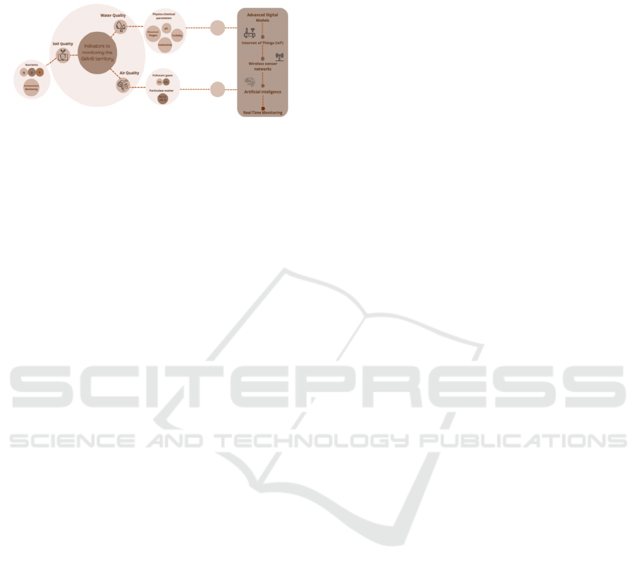
there is an increased demand for regulating the rate of
gases together with suspended particles, which cause
respiratory issues (Borghi et al., 2023).
Figure 1: Integrated environmental indicators and digital
technologies for real-time monitoring in GIAHS territories.
Soil quality is a key factor for the functionality
and longevity of GIAHS sites. For this reason,
systematic monitoring should detect pollutants like
heavy metals and pesticide residues, which are toxic
to ecosystems and human health. A complementary
approach involves monitoring basic nutrients such as
nitrogen, phosphorus, potassium and even organic
matter, key indicators of soil fertility and the
preservation of local balances in the ecosystem
(Rashid et al., 2023).
However, to ensure real-time monitoring, it is also
essential to implement intelligent digital models, such
as wireless sensor networks, the Internet of Things
(IoT), and artificial intelligence (Miller et al., 2025).
This approach allows for the continuous collection of
data on soil nutrients and pollutants, water quality and
availability, pollutant gases concentrations (Musa et
al., 2024), and the presence of suspended particles.
This provides a clear overview of the ecological
condition of the monitored area (Mansoor et al.,
2025).
Incorporating these models within GIAHS sites is
original, since it becomes possible to streamline
environmental control procedures, providing added
value to local products, assisting in fortifying the
resilience of communities faced with external
demands, for example, industrialization and over-use
of toxic agents in agriculture (Martins et al., 2022).
By connecting ancient wisdom with new
technologies, adhering to the percept
i
on of dynamic
conservation advocated by FAO, a solid and versatile
model can be devised with a perspective that ensures
cultural and ecological integrity preservation of the
GIAHS, assuring a long-term sustainability.
2.3 Key Challenges to Effective
Real-Time Monitoring
Digital ecosystems offer great potential for GIAHS
monitoring but face significant challenges
(Miller et al., 2025).
One of the main challenges is associated with the
enormous technical and architectural complexity of
these systems, since they are integrated systems based
on the IoT, which require a multi-layered with each
layer having a specific function (Maurya et al., 2024).
On the other hand, one of the major challenges of
these systems is closely linked to the management of
large volumes of data (Big Data). The large amounts
of data from the sensors, images from satellites and
meteorological data require acquisition, storage,
processing and analysis processes that are often not
available in this type of territory, due to a lack of
technical capacity, specialized human resources and
limited technological infrastructures. Due to these
challenges, real-time monitoring of this data can often
be compromised, thus interfering with the reliability
and usefulness of the results (Miller et al., 2025).
Regarding the limitations of digital ecosystems,
we highlight the difficulty for merging heterogeneous
data from multiple devices and platforms, since
efficient integration between geographic information
systems, wireless sensor networks and data
management platforms requires the adoption of
standardized protocols (Pan et al., 2023). Another
limitation to consider focuses on the economic
sustainability of these digital systems, often identified
as one of the most critical being also undervalued in
the planning and implementation phases. Maintaining
digital infrastructures, including sensors,
communication networks, data storage and
processing platforms, entails significant operating
costs that can compromise long-term viability,
especially in GIAHS territories located in rural or
remote areas, where technical and financial resources
tend to be more limited (Miller et al., 2025; M. Nawaz
& M. Babar, 2025).
On the other hand, the limited availability of
electrical infrastructure leads to a high dependence on
renewable energy sources, such as solar panels, to
power this type of digital monitoring solution.
However, these methodologies present significant
vulnerabilities, which may reduce system reliability
in adverse conditions (Abdelhamid et al., 2025).
Finally, one of the factors that could be a limitation
for monitoring these territories is the acceptance and
adaptation of local communities. Adopting new
digital technologies requires training and technical
skills, which poses a major challenge considering that
the population is mostly elderly in these communities.
Therefore, measures must, be taken to minimize the
changes caused in local areas, and the population
must be included as a central element of digital
Integrated Approaches to Monitoring GIAHS Territories: Requirements, Telematics, Sensorization and Intelligent Management Solutions
599

ecosystems creating a link between technological
innovation and local knowledge (Zhang et al., 2024).
Although IoT-based digital ecosystems offer a
promising model for real-time monitoring, it is
important to recognize that they have limitations, so
it is crucial to implement solutions that are adapted
and customized to the location of interest.
3 TELEMATICS,
SENSORIZATION AND
INTELLIGENT MANAGEMENT
SOLUTIONS
Effective management of GIAHS territories requires
a precise, sustainable and technologically integrated
approach. Nowadays, there are telematics solutions
on the market offering a range of technological tools
to improve the efficiency and effectiveness of
monitoring and managing these territories, including
high-resolution satellite images, unmanned aerial
vehicles (UAVs) and environmental sensors
deployed on site.
However, the effectiveness of these technologies
increases significantly when integrated into advanced
information management platforms, with data
processing and analysis capabilities, as well as
alarmist capabilities, thus facilitating the early
identification of anomalies or trends (Shar et al.,
2024).
3.1 Satellite Images
Environmental monitoring based on high-resolution
satellite images has developed into a useful
instrument in many scientific and operational
applications in natural resource management,
precision agriculture and natural disaster monitoring
(Sishodia et al., 2020). Such a technique depends on
the frequent scanning of the Earth's surface through
the assistance of satellites equipped with special
sensors. The environment is subsequently
recognized, measured and quantified with a high
degree of spatial and temporal precision (Shar et al.,
2024; Sishodia et al., 2020).
For such a permanent and accurate observation,
satellites such as Sentinel-2, Landsat-8 and
WorlsView-3 are used with spatial resolutions
ranging up to 0.5 meters and with adequate temporal
repetition for the detection of climate change (Drusch
et al., 2012). Such use is particularly beneficial in
areas such as precision agriculture, surveillance of
natural hazards and natural resource management
(Segarra et al., 2020).
The data recording is based on sensors on the
satellites, depending on the type of radiation the
sensors are capable of recording. With regards to
optical sensors, they can capture radiation being
reflected in the near-infrared and the visible range,
performing well in situations where the atmosphere is
still and the conditions clear (Wulder et al., 2016).
Thermal sensors, in contrast, pick up emitted
radiation and can estimate the temperatures at the
surface, while the Synthetic Aperture Radar (SAR)
sensors have the advantage of being independent of
the presence or absence of the light conditions, or fog,
ideal under unfavorable weather (Amitrano et al.,
2021). Accordingly, by the employment of this type
of technology, the evolution in the agricultural
landscapes of GIAHS locations over a period of a few
decades can be examined, and thus accurate
discernment of changes in behavioral attributes in the
land can be identified in a bid to reveal complex and
seasonal dynamics.
However, before an analysis can be conducted on
the images that have been captured, they are required
to go through a pre-processing stage. In this stage,
data will go through the process of radiometric and
atmospheric correction through software such as
Sen2Cor to remove the effect caused by atmospheres
in order to retrieve more accurate surface reflectance
(Main-Knorn et al., 2017). Concurrent with these
atmospheric corrections is the function played by the
radiometric calibration in the quality aspect of the
results. It is typically conducted through the support
of polynomial models whose results have coefficients
of determination greater than 0.88 and root mean
square errors (RMSE) lesser compared to 0.01 (Raut
et al., 2019). With the radiation values properly
corrected, we can now focus on the spatial correction
of the images for them to possess geographical acuity.
Orthorectification ensures accurate spatial correction
with such errors lesser compared to 1 pixel in size. In
addition, technologies such as pan-sharpening fusion
are applied in the improvement of spatial resolution,
particularly in panchromatic and multispectral
sensors as used in WorldView-3 (Park et al., 2020).
Remotely sensed imagery is therefore a valuable
tool in the surveillance of the territory as it has
multiple applications. When in the agricultural area,
they allow for one to monitor the status of the
vegetation, making it possible for the pest to be
identified early, assisting in the assessment of the
water stress and in the making of the decision
regarding fertilization and harvesting (Chattopadhyay
et al., 2024).
TISAS 2025 - Special Session on Trustworthy and Intelligent Smart Agriculture Systems: AI, Blockchain, and IoT Convergence
600

From the environment standpoint, the method has
proven effective in the analysis of illegal
deforestation, assistance in the management of
protected areas and analysis of the impacts of large
infrastructure. Relating to the GIAHS areas, the
utilization of time series of Sentinel-2 and Landsat
imagery has proved extremely effective in the
identification of phenological cycles and the analysis
of the impacts of agricultural and environment
policies.
Among the various associated advantages, global
coverage stands out. However, there are significant
limitations, such as decreased accuracy on cloudy
days and the need for technical resources to process
and interpret the acquired data. With the continuing
development in the methods of artificial intelligence,
it has been made possible to overcome some
shortcomings through the utilization of convulsive
neural networks assisting in the aspect of precision as
well as the aspect of making analysis processes more
automatic (Victor et al., 2024).
3.2 Unmanned Aerial Vehicles (UAVs)
Environmental monitoring by UAVs, also known as
drones, has been a useful tool for the extraction of
high spatial coverage data in a manner that facilitates
observation, description and analysis of ecological
and biophysical characteristics in spatial and
temporal scales difficult to access through the
utilization of other methods (Singh et al., 2024).
UAVs have centimetric imagery offering the
potential for extracting data in ultra-high spatial
resolutions and customized cadences in such a
manner that dynamics in natural habitats can readily
be understood (Singh et al., 2024).
UAVs are multi-purpose platforms equipped with
the latest RGB cameras, multispectral sensors,
hyperspectral sensors and thermal sensors making it
possible to collect images in very high resolutions in
the range from 2 up to 5 cm/pixel depending on the
installed flight altitude and the quality level of the
installed sensor (Cao et al., 2021).
Sensors such as the RedEdge-P whose flight
altitudes range to almost 60 meters offer centimetric
resolution imagery marrying RGB and multispectral
bands such as red and near-infrared. With such
arrangements, it is possible to estimate accurately the
spectral indices such as NDVI (Normalized
Difference Vegetation Index) and NDRE
(Normalized Difference Red Edge) useful for
detecting water stress and vegetation health, with a
specificity equal or superior to ground sensors
(Bhagat et al., 2020; De Castro et al., 2021).
Alongside the above elements, the integration of
thermal cameras in UAVs has been extremely
effective in identifying temperature changes in
vegetation and soil, with the ability to recognize
thermal anomalies with a precision ranging from up
to ±0.1 °C, particularly effective in the early
identification of wildfires or in the delineation of soil
temperature and humidity (Guan et al., 2022). The
non-invasive capability provided by this form of
remote sensing is matched by GNSS (Global
Navigation Satellite System) navigation tools and
also RealTime Kinematic (RTK) differential
correction tools, which provide position precision
levels below 2 cm, making them instrumental in
applications where there is a need for high spatial
precision (Niu et al., 2024). UAVs autonomy and
range depend on the model, with models such as the
DJI Matrice 300 RTK providing flight durations
exceeding 50 minutes and real-time data
communication where the distances go up to 15 km
(Czyża et al., 2023).
Furthermore, various studies emphasize the
potentiality for the use of UAVs in numerous areas of
the environment domain, most notably the efficacy of
this approach in the description of vegetation in
mediterranean crop regions, making it possible for
there to be multi-temporal analysis of land utilization
where there is the possibility of detecting variations
existing in crop dynamics and variations by season
(Yeom et al. 2019). Conversely, UAV utilization in
agricultural environments has been gaining
popularity, most notably given the efficacy with
which this method can monitor agronomic parameters
in real-time. Such systems are increasingly applied in
the early identification of nutritional deficiencies, for
diagnosing water stress and in the identification of
diseases where there can be the implementation of
faster and more accurate measures contributing
towards sustainable precision agriculture (Sharma et
al., 2025).
The advancing development of UAV systems
with increasing autonomy, decreased size and
integration with sensors and machine learning
approaches for automatic analysis of the gathered
data enables new applications towards near-real-time
observation of the environment at lowest operating
costs and maximum flexibility (Tabassum, 2020). In
such a manner, UAVs are receiving a vigorous large-
scale response towards current environmental
concerns with the optimum compromise between
spatial resolution, accessibility and repetition
frequency in the observation (Manjunath & Kumar,
2025).
Integrated Approaches to Monitoring GIAHS Territories: Requirements, Telematics, Sensorization and Intelligent Management Solutions
601

3.3 Sensors Implemented in Situ
Sensors have proven to be effective in monitoring and
managing rural areas, especially natural resources.
Field deployed sensors monitor physical, chemical,
and biological parameters with high temporal and
spatial precision. Using of this type of approach is
worthwhile particularly in remotely located areas
with poor infrastructure where the traditional
methods of monitoring are unsuitable or expensive
(Abdinoor et al., 2025). Accordingly, in the
remainder of this section we will consider some
current solutions for the measurement of air, water
and soil quality.
Meteorological monitoring uses industrial-grade
sensors designed to withstand extreme temperatures,
high humidity or heavy rainfall (Concas et al., 2021).
A representative example of this type of device is the
CWT-BY Outdoor Atmosphere Sensor
(ComWinTop), which brings together, the ability to
collect information such as ambient temperature,
relative humidity, atmospheric pressure, noise levels,
light intensity, particulate matter (PM2.5 and PM10)
and carbon dioxide (CO2) concentration, all in a
single module. This sensor module uses RS485
communication (Modbus RTU), is duly protected by
an IP65 shield and has an accuracy of ±0.3 °C for
temperature and ±2% for humidity accuracy. It is
widely used in agricultural and forestry monitoring
(Concas et al., 2021). Similarly, SenseCap sensors
(Seeed Studio) offer precision, IP66 resistance,
LoRaWAN, and up to 10 years of autonomy, ideal for
remote or low-connectivity locations (González et al.,
2020).
On the other hand, gas concentration monitoring
in rural areas is increasingly important for assessing
air quality. Carbon dioxide (CO₂), ammonia (NH₃),
methane (CH₄), nitrogen dioxide (NO₂), ozone (O₃)
and carbon monoxide (CO) are gases commonly
linked to declining air quality and public concern. In
the search for means of eliminating this pest,
Libelium constitutes a formidable and multi-faced
response in this regard in the sense that it has modular
sensors for the above-mentioned gases and other
gases on the basis of various principles of perception,
namely electrochemical sensors, non-dispersive
infrared (NDIR) and catalytic sensors according to
the nature of the compound to be monitored (Hayat et
al., 2019). The CO₂ NDIR sensor measures up to 5000
ppm and is widely used in greenhouses and compost
facilities for CO₂ accumulation control (Pandey &
Kim, 2007). Electrochemical NH₃ sensors detect
below 5 ppm, ideal for livestock environments where
exposure may harm animal and human health
(Moshayedi et al., 2023).
By integrating these sensors into wireless
communication networks, it is possible to efficiently
monitor large areas, with high autonomy and low
energy impact, promoting the implementation of
sustainable strategies for environmental management
(Concas et al., 2021). Other complementary examples
include the MIPEX-02, a multi-gas sensor that is
suitable for rural and industrial environments, where
its architecture allows to combine the detection of
CO₂ and CH₄ using dual-beam NDIR technology,
guaranteeing reliable measurements, even in adverse
conditions such as excessive dust or high humidity
levels. On the other hand, sensors in the Aeroqual
Series 500 range, which are compatible with various
electrochemical and photoionization detection (PID)
modules, enable mobile data collection in the field
and are suitable for monitoring gas emissions and
assessing air quality in forest areas (Mead et al., 2013;
Whitehill et al., 2022).
Water monitoring is essential for assessing
quality and availability, especially in areas prone to
scarcity or contamination. To assess water
availability, level sensors based on hydrostatic
pressure are used, such as the Liquid Level Sensor
For Water Level (Seed Studio) or the OTT Orpheus
Mini probe, that measure the height of the water
column with high precision (Whitehill et al., 2022).
In addition, these sensors have IP68 protection, ideal
for outdoor water monitoring using pressure
transducers that convert column height into digital
data (Whitehill et al., 2022).
When sites are difficult to access or susceptible to
contamination, ultrasonic or radar sensors can be
implemented, such as the VEGAPULS C 11, that
performs measurements without direct contact (Wu et
al., 2023). About water quality assessment, multi-
parametric sensors such as the YSI EX02 or Proteus
P35 can be implemented, which are made up of
replaceable modules that make it possible to
simultaneously measure pH, electrical conductivity,
dissolved oxygen, turbidity and temperature, among
others, with high precision and resistance to
biofouling (Snazelle, 2015). In addition to these
solutions, Seeed Studio integrates specific and
independent modules for monitoring parameters such
as electrical conductivity, pH, turbidity and water
temperature, developed with the purpose of being
integrated into real-time monitoring systems, making
it possible to remotely and continuously collect
essential data for the characterization and
management of aquatic ecosystems.
TISAS 2025 - Special Session on Trustworthy and Intelligent Smart Agriculture Systems: AI, Blockchain, and IoT Convergence
602

Concerning soil quality, dielectric sensors for
nutrients, such as the Soil NPK Sensor (Renke), are
capable to collect data on the temperature, pH and
electrical conductivity of soils, while also being able
to estimate the concentration of nutrients such as
potassium, phosphorus and nitrogen, all with
response times of less than 1 second. In addition to
these potentialities, it also has an IP68 protection
rating, a decisive factor for its application in open
field agricultural monitoring systems (Afridi et al.,
2022). Another representative sensor is the Teralytic,
capable of measuring pH, humidity, temperature, and
NPK nutrients using LoRa for wireless data
transmission, ideal for sustainable agriculture (Santos
& Armstrong, 2024).
The wide range of sensors available today enables
the development of robust systems that balance
accuracy, sensitivity, durability, wireless integration,
and long-term stability, thus operating reliably in
harsh conditions with minimal human intervention.
Therefore, to meet these needs, it is important to
use local processing units capable of interpreting the
electrical signals generated by the sensors and, thus,
performing basic pre-processing and communication
operations, highlighting microcontrollers as essential
units for these systems. Arduino, a device based on
the ATmega328P microprocessor, is one of the most
widely used, running at 16 MHz with 32 Kb of flash
memory. These features make it ideal for low-
complexity applications (Tukur Balarabe et al.,
2019). The ESP32 is characterized by combining a
240 MHz dual-core CPU with Wi-Fi and Bluetooth
connectivity and a low-power deep-sleep mode (<150
µA), which makes this system suitable for
autonomous systems with low energy requirements
(M. Broell et al., 2023).
The Raspberry Pi series, on the other hand,
represents a more robust and versatile solution,
including models ranging from the Model B (ARM
single-core at 700 MHz, 256 MB RAM) to the
Raspberry Pi 4 and 5, equipped with ARM Cortex-
A72 quad-core processors up to 2.4 GHz, 8 GB RAM
and multiple communication interfaces (USB 3.0,
HDMI, gigabit Ethernet, Wi-Fi, Bluetooth), operating
with a Linux system (Hosny et al., 2023).
In addition, the STM32, ARM Cortex-M
microcontrollers, developed by STMicroelectronics,
stand out for their high energy efficiency, good
communication capacity (up to 72 MHz), multiple
communication channels (USART, SPI, I²C, CAN)
and robustness, being widely used in applications that
require stability and low consumption over long
periods of operation (D. Li et al., 2020).
With the adoption of these devices, it becomes
possible to implement edge computing solutions,
significantly reducing latency periods and the
bandwidth required for data transmission, while
increasing the resilience of these solutions in areas
with limited connectivity (Dallaf, 2025).
But for everything to work, there must be
protocols for the sensors and the control panels to talk
to one another. I²C (Inter-Integrated Circuit) protocol
is often used in compact systems due to its simplicity
and low energy consumption, linking up to 127
devices by means of just two wires, the SDA (Serial
Data Line) and the SCL (Serial Clock Line) lines.
This protocol offers a range of speeds from 100 kbps
(standard mode) up to 3.4 Mbps (high speed mode),
but with limited range of up until about 1 meter. On
the other hand, the SPI (Serial Peripheral Interface), a
substitute protocol with higher data transfer speed (up
until 10 Mbps) and lower latency can also be used in
short-range systems like the previous one.
For applications requiring longer distances, RS-
232 supports point-to-point communication of up to
15 meters at 20Kbps, however, it is sensitive to noise
and does not support multiple devices on the same bus
(Rajkumar, 2025). Alternatively, there is the RS-485
protocol which uses differential signaling, allowing
speeds of up to 10 Mbps and coverage of over 1300
meters with the possibility of connecting up to 32
devices on the same bus (Scientific, n.d. ). Its use in
extensive agricultural networks has proven its
robustness in the distributed collection of
environmental data (water level, temperature, pH)
over several hectares (Mo et al., 2022).
To overcome the limitations regarding the
infrastructure in rural areas or in distant areas, long-
range and low-power communications arise as
leaders. Among these are considered LoRa, ZigBee,
Wi-Fi, GSM/GPRS, NB-IoT, 4G and 5G. The LoRa
(Long Range) stands out by the maximum range up
to 15 km, by the transmission rates from 0.3 and 27
Kbps and by the low level of consumption in the order
of 10 to 30 mW, ideal for remote and self-sustaining
nodes (Duisebekova et al., 2019). On the other hand,
ZigBee has a more limited range in the order of 10 to
100 meters and is suited in mesh architecture, being
advantageous in environments with existing physical
barriers (Fitriawan et al., 2017).
Wi-Fi provides bandwidths of more than 100
Mbps but requires greater energy consumption. On
the other hand, technologies such as GSM/GPRS
guarantee extended coverage, but the associated
disadvantage is the lower data transmission rate, up to
approximately 115 Kpbs (Hammami, 2019).
Regarding NB-IoT, this protocol operates at rates of
Integrated Approaches to Monitoring GIAHS Territories: Requirements, Telematics, Sensorization and Intelligent Management Solutions
603

between 20 and 250 Kbps, with high signal
penetration and energy efficiency (Waseem et al.,
2025).
As for 4G and the emerging 5G, they guarantee
high-speed transmissions of up to 10 Gbps, with low
latency periods of less than 1 ms in the case of 5G,
which is a determining characteristic for integrating
this type of technology into applications that require
real-time transmissions (Agiwal et al., 2016; Polak et
al., 2024).
Finally, one approach that has been shown to be
effective and amenable for integration in applications
based on IoT monitoring has been the MQTT
(Message Queue Telemetry Transport) protocol.
With TCP/IP operation and publish/subscribe
architecture usage, the MQTT protocol is a very
effective solution in applications with limited
bandwidth, varying latency or intermittent
connectivity. As MQTT is compatible with Wi-Fi, 4G
and 5G technologies, along with the availability of
configurable Quality of Service (QoS) and
bidirectional communications, results that the MQTT
protocol is particularly effective in synchronizing
sensors placed in the field with Cloud platforms with
low energy requirements (Shilpa et al., 2022).
3.4 Visualization, Analysis and
Alarming Tools
Visualization, analysis, and alert tools convert raw
data into structured, user-friendly information,
supporting efficient environmental management
(Guerbaoui et al., 2025; Olatomiwa et al., 2023).
These functions are generally integrated into digital
platforms capable of real-time data acquisition,
storage, and analysis with high scalability
(Geldenhuys et al., 2021). In the field of visualization,
platforms like Grafana and ThingsBoard offer
interactive interfaces for intuitive data representation.
Grafana supports dynamic dashboards with multiple
data sources (e.g., InfluxDB, SQL), enabling time
graphs, thematic maps, 3D modeling, and pattern
detection (Singh, 2023). ThingsBoard, on the other
hand, stands out for its object-oriented architecture
and native integration of georeferenced maps,
offering dashboards with alarm rules based on
acquired parameter values (Chen, 2023). For
analytics, Node-RED and InfluxDB stand out. Node-
RED (IBM) is a low-code tool based on visual flows
that facilitates the construction of data pipelines
through configurable nodes. It integrates IoT sensors,
preprocesses data (filtering, aggregation,
transformation) and sends it to time series databases
(Onwuegbuzie et al., 2024). InfluxDB is a database
specialized in the efficient management of time
series, which supports the integration of large
volumes of continuous data, allowing for complex
historical queries, which leads to the identification of
trends, seasonal anomalies as well as the
substantiation of mitigation strategies.
The alarming component complements these
platforms by allowing the definition of alteration
conditions based on static or dynamic limits, duly
coordinated with sending channels such as e-mail,
SMS, webhooks or internal notifications, reducing
the response time to critical events (Filip et al., 2022).
Integration with Node-RED or InfluxDB enables
anomaly detection and predictive logic, improving
failure anticipation and environmental response.
In addition, the Infracontrol Online platform (Icp
- Infraestruturas Control Portugal, Sitowise Group) is
an open cloud SaaS solution focused on the
centralized management of urban infrastructures,
such as street lighting, waste management and road
signs, as well as the integration of real-time measured
values of environmental parameters. It offers auto-
generated alerts and georeferenced tickets for
maintenance teams, plus real-time visualization and
historical data access. It has an open, scalable
architecture, permitting connectivity with IoT sensors
and interoperability with SCADA/PLC systems, to
foster an overall, integrated management of cities'
operations.
Implementation of digital architectures driven by
software like ThingsBoard, Note-Red, InfluxDB and
Grafana has turned out crucial in constructing
environmental monitoring systems, allowing for the
collection, processing and visual representation of
data in real time. Platforms such as Infracontrol offer
robust mechanisms for operational visualization and
alert management, so this platform can be used to
supervise urban and environmental infrastructures,
aiding decision-making and territorial coordination.
4 FUTURE PRESPECTIVES:
PROPOSED TECHNOLOGICAL
ARCHITECTURE AS A
SOLUTION TO GIAHS
MONITORING
One of the modern world's great anxieties, in the face
of phenomena such as climate change, adoption of
industrial agronomy and devastation of the
environment, is the real-time surveillance of GIAHS
regions - as has been stated in this review.
Sophisticated technological systems should be
TISAS 2025 - Special Session on Trustworthy and Intelligent Smart Agriculture Systems: AI, Blockchain, and IoT Convergence
604
implemented to enable these systems to be surveyed
in real time in a permanent, precise and articulated
way (Jiao et al., 2022). However, the adoption of
these intelligent instruments has numerous
constraints, which highlights the need for the design
of a superior digital architecture able to interconnect
two fundamental characteristics: autonomy and
adaptation towards the territory. With this objective
in mind, in this section we propose the adoption of an
intelligent technological architecture, designed to
offer a sound digital surveillance instrument. This
proposal integrates environmental sensing, data
processing, information management and user
interaction components.
This system has been digitized for the collection
and processing in real time of the data to facilitate the
making of the required and strategic decisions as key
factors in the proper management of the natural
resources in GIAHS sites.
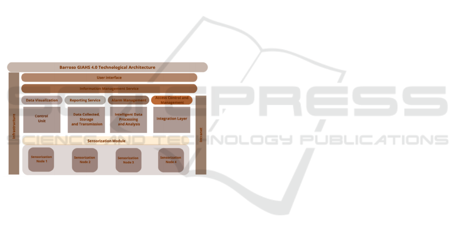
A technological architecture was conceived to
remotely monitor a GIAHS site, in the Barroso area,
in intelligent and integrated manner according to a
modular and expandable model represented in Fig. 2.
Figure 2: Technological Architecture Overview.
The system was designed to ensure proper
collection of environmental data through intelligent
processing devices which facilitate the distribution of
the data in real-time to the various users and
management entities.
At the center of the entire system is the
Sensorization Module whose function is the
extraction of desired environmental parameters on the
soil, water, atmosphere and climatic conditions to
accurately estimate the ecological condition of the
area.
The main element in this architecture is the
Control Unit where the flow of data from the sensors
is directed and the entire operation of the sensor
module is carried out. The control unit acts as the
module manager for the data received from the
sensors in such a way the received data is routed
through the Data Collection, Storage and
Transmission module where the data is formatted and
sufficiently set up for local storage and subsequent
transmission in secured mode back in the other
system modules.
Received data is processed and correctly added
into the Information Management Service with the
capability for real-time visualization, generation of
comprehensive graphic reports, and alarm
management. Access Control and Management
Module allows for the definition and management of
the degrees of access with the purpose of preserving
confidentiality and security of the data.
Finally, the User Interface is the central area in
which the system and the different users
communicate at, where there is visualization in real-
time at a detailed level of the data, establishment of
the alerts and reading the reports.
Briefly, the architecture represents a functional
response towards the GIAHS regions observation
difficulties. Beyond simplifying the local
management, it is even transferable for other regions
and show how the technology can offer concrete
assistance in the conservation and the development of
unique agricultural systems all over the world.
5 CONCLUSIONS
There is a requirement for customized digital
architectures for effective monitoring and
conservation of GIAHS sites. The use of real-time
monitoring of environments with advanced
technologies such as sensors, UAVs, and satellite
images has the potential to enhance adaptive
management as well as site resilience. Against this
background, a technological structure for the
development of an intelligent monitoring system for
Barroso region, in Portugal, has been proposed being
capable to integrate sensor networks, edge
computing, data analysis and visualization tools, and
user-focused alert handling systems.
Its biggest advantage is that it is repeatable and
transferable so that it could potentially be applied to
other areas of GIAHS with different realities and
operational demands.
ACKNOWLEDGEMENTS
The authors are grateful to the Fundação “La Caixa”
and FCT for the financial support through Project
“Barroso GIAHS 4.0 - Ecossistema Digital de
Monitorização e Gestão Ambiental do Barroso”,
Integrated Approaches to Monitoring GIAHS Territories: Requirements, Telematics, Sensorization and Intelligent Management Solutions
605

Projeto Piloto Inovador - Programa PROMOVE “O
futuro do Interior”, call 2022. J. Soares and C.
Teixeira acknowledges national public funding
through “Investimento RE-C05-i02 – Missão
Interface N.° 01/C05-i02/2022”, a project supported
under the PRR (www.recuperarportugal.gov.pt), and
financed by the European Union/Next Generation
EU.
REFERENCES
Abdelhamid, M. A., Abdelkader, T. K., Sayed, H. A. A.,
Zhang, Z., Zhao, X., & Atia, M.F. (2025). Design and
evaluation of a solar powered smart irrigation systemfor
sustainable Urban Agriculture. Scientific Reports,
15(1), 11761.
Abdinoor, J. A., Hashim, Z. K., Horváth, B., Zsebő, S.,
Stencinger, D., Hegedüs, G.,Bede, L., Ijaz, A., &
Kulmány, I. M. (2025). Performance of Low-Cost Air
Temperature Sensors and Applied Calibration
Techniques—A Systematic Review. Atmosphere,
16(7), 842.
Afridi, W. A., Akhter, F., Vitoria, I., & Mukhopadhyay, S.
C. (2022). A technology review and field testing of a
soil water quality monitoring system. International
Conference on Sensing Technology, Agiwal, M., Roy,
A., & Saxena, N. (2016). Next Generation 5G Wireless
Networks: A Comprehensive Survey. IEEE
Communications Surveys & Tutorials, 18, 1-1.
Agnoletti, M., & Santoro, A. (2022). Agricultural heritage
systems and agrobiodiversity. Biodiversity and
Conservation, 31.
Amitrano, D., Di Martino, G., Guida, R., Iervolino, P.,
Iodice, A., Papa, M. N., Riccio, D., & Ruello, G.
(2021). Earth Environmental Monitoring Using Multi-
Temporal Synthetic Aperture Radar: A Critical Review
of Selected Applications. Remote Sensing, 13(4), 604.
Arnés García, M., Yagüe, J. L., de Nicolás, V. L., & Díaz-
Puente, J. M. (2020). Characterization of Globally
Important Agricultural Heritage Systems (GIAHS) in
Europe. Sustainability, 12(4), 1611.
A., Igathinathane, C., Bandillo, N., & Flores, P. (2025).
Optimizing integration techniques for UAS and satellite
image data in precision agriculture—a review. Frontiers
in Remote Sensing, 6, 1622884.
Bhagat, V., Kadam, A., & Kumar, S. (2020). Analysis of
Remote Sensing based Vegetation Indices (VIs) for
Unmanned Aerial System (UAS): A Review. Remote
Sensing of Land, 3, 58-73.
Borghi, F., Spinazzé, A., De Nardis, N., Straccini, S.,
Rovelli, S., Fanti, G., Oxoli, D., Cattaneo, A., Cavallo,
D., & Brovelli, M. (2023). Studies on Air Pollution and
Air Quality in Rural and Agricultural Environments: A
Systematic Review. Environments, 10, 208.
Cao, X., Liu, Y., Yu, R., Han, D., & Su, B. (2021). A
Comparison of UAV RGB and Multispectral Imaging
in Phenotyping for Stay Green of Wheat Population.
Remote Sensing, 13(24), 5173.
Chattopadhyay, D., Balachandra, Y., P, A., Dutta, A., Sahu,
T., Panotra, N., G, M., & Charitha, K. (2024). Precision
Agriculture Technologies for Early Detection of Crop
Pests and Diseases. UTTAR PRADESH JOURNAL
OF ZOOLOGY, 15, 328-342.
Chen, K. (2023). An Adaptable IoT Rule Engine
Framework for Dataflow Monitoring and Control
Strategies.
Concas, F., Mineraud, J., Lagerspetz, E., Varjonen, S., Liu,
X., Puolamäki, K., Nurmi, P., & Tarkoma, S. (2021).
Low-cost outdoor air quality monitoring and sensor
calibration: A survey and critical analysis. ACM
Transactions on Sensor Networks (TOSN), 17(2), 1-44.
Czyża, S., Szuniewicz, K., Kowalczyk, K., Dumalski, A.,
Ogrodniczak, M., & Zieleniewicz, Ł. (2023).
Assessment of Accuracy in Unmanned Aerial
Vehicle (UAV) Pose Estimation with the REAL-Time
Kinematic (RTK) Method on the Example of DJI
Matrice 300 RTK. Sensors, 23, 2092.
Dallaf, A. (2025). Edge Computing in IoT Networks:
Enhancing Efficiency, Reducing Latency, and
Improving Scalability. International Journal of Advanced
Network, Monitoring and Controls, 10, 2025.
De Castro, A., Shi, Y., Maja, J. M., & Peña-Barragán, J. M.
(2021). UAVs for Vegetation Monitoring: Overview
and Recent Scientific Contributions. Remote Sensing,
13, 2139.
Drusch, M., Del Bello, U., Carlier, S., Colin, O., Fernandez,
V., Gascon, F., Hoersch, B., Isola, C., Laberinti, P.,
Martimort, P., Meygret, A., Spoto, F., Sy, O.,
Marchese, F., & Bargellini, P. (2012). Sentinel-2:
ESA's Optical High-Resolution Mission for GMES
Operational Services. Remote Sensing of Environment,
120, 25-36.
Duisebekova, K. S., Sarsenova, Z. N., Pyagay, V. T.,
Tuyakova, Z. N., Duzbayev, N. T., Aitmagambetov, A.
Z., & Amanzholova, S. T. (2019). Environmental
monitoring system for analysis of climatic and
ecological changes using LoRa technology.
Proceedings of the 5th International Conf. on
Engineering and MIS,
Filip, I.-D., Iliescu, C.-M., & Pop, F. (2022). Assertive,
Selective, Scalable IoT-Based Warning System.
Sensors, 22(3), 1015.
Fitriawan, H., Susanto, M., Arifin, A. S., Mausa, D., &
Trisanto, A. (2017). ZigBee based wireless sensor
networks and performance analysis in various
environments. 2017 15th international conference on
quality in research (QiR): International symposium on
electrical and computer engineering, Food, &
Agriculture Organization of the United, N. (2009).
Globally Important Agricultural Heritage Systems. FAO.
Geldenhuys, M. K., Will, J., Pfister, B. J., Haug, M.,
Scharmann, A., & Thamsen, L. (2021). Dependable iot
data stream processing for monitoring and control of
urban infrastructures. 2021 IEEE International
Conference on Cloud Engineering (IC2E),(pp.244-
250).IEEE.
TISAS 2025 - Special Session on Trustworthy and Intelligent Smart Agriculture Systems: AI, Blockchain, and IoT Convergence
606

González, E., Casanova-Chafer, J., Romero, A., Vilanova,
X., Mitrovics, J., & Llobet, E. (2020). LoRa Sensor
Network Development for Air Quality Monitoring or
Detecting Gas Leakage Events. Sensors, 20(21), 6225.
Guan, S., Zhu, Z., & Wang, G. (2022). A Review on UAV-
Based Remote Sensing Technologies for Construction
and Civil Applications. Drones, 6(5), 117.
Guerbaoui, M., el Faiz, S., Ed-Dahhak, A., Lachhab, A.,
Benhala, B., Bakziz, Z., Ichou, I., & Selmani, A.
(2025). From Data to Decisions: A Smart IoT and
Cloud Approach to Environmental Monitoring. E3S
Web of Conferences,
Hammami, A. (2019). Smart environment data monitoring.
2019 International Conference on Computer and
Information Sciences (ICCIS).
Hayat, H., Griuiths, T., Brennan, D., Lewis, R. P., Barclay,
M., Weirman, C., Philip, B., & Searle, J. R. (2019). The
State-of-the-Art of Sensors and Environmental
Monitoring Technologies in Buildings. Sensors,
19(17), 3648.
Hosny, K. M., Magdi, A., Salah, A., El-Komy, O., &
Lashin, N. A. (2023). Internet of things applications
using Raspberry-Pi: a survey. International Journal of
Electrical & Computer Engineering (2088-8708), 13(1).
Jiao, W., Yang, X., & Min, Q. (2022). A review of the
progress in globally important agricultural heritage
systems (GIAHS) monitoring. Sustainability, 14(16),
9958.
Koohafkan, P., Altieri, M., & Initiative, G. (2011). A
methodological framework for the dynamic conservation
of agricultural heritage systems. Geneva (Switzerland):
Land and Water Division, The Food and Agriculture
Organization (FAO) of the United Nations, 1-61.
Krklješ, D. B., Kitić, G. V., Petes, C. M., Birgermajer, S.
S., Stanojev, J. D., Bajac, B. M., Panić, M. N., Radonić,
V. M., Brčeski, I. D., & Janković, N. N. (2024).
Multiparameter water quality monitoring system for
continuous monitoring of fresh waters. IEEE Sensors
Journal, 24(7), 11246-11260.
Li, D., Wu, T., Li, X., He, Q., & Cui, Z. (2020). A Wireless
Multisensor Node for Long- Term Environmental
Parameters Monitoring. Journal of Electrical and
Computer Engineering, 2020(1), 8872711.
Li, J., Pei, Y., Zhao, S., Xiao, R., Sang, X., & Zhang, C.
(2020). A Review of Remote Sensing for
Environmental Monitoring in China. Remote Sensing,
12(7), 1130.
Lin, M., Wang, M., Lu, Y., Zhou, G., Shen, W., Yin, J., &
You, J. (2025). Synergizing Conservation and Tourism
Utilization in Agricultural Heritage Sites: A
Comparative Analysis of Economic Resilience in
Wujiang and Longsheng, China. Land, 14(4), 796.
M. Broell, L., Hanshans, C., & Kimmerle, D. (2023). IoT
on an ESP32: Optimization Methods Regarding Battery
Life and Write Speed to an SD-Card. In S.Goundar
(Ed.), Edge Computing - Technology, Management and
Integration. IntechOpen.
Ma, N., Yang, L., Min, Q., Keyu, B., & Wenhua, L. (2021).
The Significance of Traditional Culture for Agricultural
Biodiversity—Experiences from GIAHS. Journal of
Resources and Ecology, 12.
Main-Knorn, M., Pflug, B., Louis, J., Debaecker, V.,
Müller-Wilm, U., & Gascon, F. (2017). Sen2Cor for
Sentinel-2.
Manjunath, & Kumar, A. (2025). The Future of
Autonomous Drones in Environmental Monitoring and
Disaster Management. International Journal of
Scientific Research and Engineering Trends.
Mansoor, S., Iqbal, S., Popescu, S., Kim, S., Chung, Y., &
Baek, J.-H. (2025). Integration of smart sensors and
IOT in precision agriculture: trends, challenges and
future prospectives. Frontiers in Plant Science.
Martins, J., Gonçalves, C., Silva, J., Gonçalves, R., &
Branco, F. (2022). Digital Ecosystem Model for
GIAHS: The Barroso Agro-Sylvo-Pastoral System.
Sustainability, 14(16), 10349.
Maurya, S., Pal, O., & Sarvakar, K. (2024). Layered
Architecture of IoT. In (pp. 164-194).
Mead, M. I., Popoola, O. A. M., Stewart, G. B., Landshou,
P., Calleja, M., Hayes, M., Baldovi, J. J., McLeod, M.
W., Hodgson, T. F., Dicks, J., Lewis, A., Cohen, J.,
Baron, R., Sauell, J. R., & Jones, R. L. (2013). The use
of electrochemical sensors for monitoring urban air
quality in low-cost, high-density networks.
Atmospheric Environment, 70, 186-203.
Mekouar, M. A. (2023). Food and Agriculture Organization
of the United Nations (FAO). Yearbook of International
Environmental Law, 34(1), yvae031.
Miller, T., Mikiciuk, G., Durlik, I., Mikiciuk, M.,
Łobodzińska, A., & Śnieg, M. (2025a). The IoT and AI
in Agriculture: The Time Is Now—A Systematic
Review of Smart Sensing Technologies. Sensors,
25(12), 3583.
Mo, C., Xie, Z., & Wang, J. (2022). [Retracted] Large-Area
Saline-Alkali-Tolerant Rice Growth Environment
Monitoring System Based on LoRa+UAV. Advances in
Materials Science and Engineering, 2022(1), 9003753.
Morchid, A., El Alami, R., Raezah, A. A., & Sabbar, Y.
(2024). Applications of internet of things (IoT) and
sensors technology to increase food security and
agricultural Sustainability: Benefits and challenges.
Ain Shams Engineering Journal, 15(3), 102509.
Moshayedi, A. J., Khan, A., Hu, J., Nawaz, A., & Zhu, J.
(2023). E-Nose-Driven Advancements in Ammonia
Gas Detection: A Comprehensive Review from
Traditional to Cutting-Edge Systems in Indoor to
Outdoor Agriculture. Sustainability, 15.
Musa, P., Sugeru, H., & Wibowo, E. P. (2024). Wireless
Sensor Networks for Precision Agriculture: A Review
of NPK Sensor Implementations. Sensors, 24(1), 51.
Nan, M., Lun, Y., Qingwen, M., Keyu, B., & Wenhua, L.
(2021). The significance of traditional culture for
agricultural biodiversity—Experiences from GIAHS.
Journal of Resources and Ecology, 12(4), 453-461.
Nawaz, M., & Babar, M. I. K. (2025). IoT and AI for smart
agriculture in resource-constrained environments:
challenges, opportunities and solutions. Discover
Internet of Things, 5(1), 24.
Integrated Approaches to Monitoring GIAHS Territories: Requirements, Telematics, Sensorization and Intelligent Management Solutions
607

Niu, Z., Xia, H., Tao, P., & Ke, T. (2024). Accuracy
Assessment of UAV Photogrammetry System with
RTK Measurements for Direct Georeferencing (Vol. X-
1-2024).
Olatomiwa, L., Ambafi, J. G., Dauda, U. S., Longe, O. M.,
Jack, K. E., Ayoade, I. A., Abubakar, I. N., & Sanusi,
A. K. (2023). A Review of Internet of Things-Based
Visualisation Platforms for Tracking Household
Carbon Footprints. Sustainability, 15(20), 15016.
Onwuegbuzie, I., Olowojebutu, A., & Kayode, A. (2024).
Node-RED and IoT Analytics: A Real-Time Data
Processing and Visualization Platform. 1, 1-12.
Pan, Y., Sun, J., Yu, H., Bai, G., Ge, Y., Luck, J., & Awada,
T. (2023). Transforming agriculture with intelligent
data management and insights. 2023 IEEE International
Conference on Big Data (BigData).
Pandey, S. K., & Kim, K.-H. (2007). The Relative
Performance of NDIR-based Sensors in the Near Real-
time Analysis of CO2 in Air. Sensors, 7(9), 1683-1696.
Park, H., Kim, N., Park, S., & Choi, J. (2020). Sharpening
of Worldview-3 Satellite Images by Generating
Optimal High-Spatial-Resolution Images. Applied
Sciences, 10(20), 7313.
Polak, L., Kufa, J., Sotner, R., & Fryza, T. (2024).
Measurement and Analysis of 4G/5G Mobile Signal
Coverage in a Heavy Industry Environment. Sensors,
24(8), 2538.
Rajkumar, P. (2025). Humidity and Temperature
Monitoring System using Raspberry Pi via RS232
Networking. Array, 100464.
Rashid, A., Schutte, B. J., Ulery, A., Deyholos, M. K.,
Sanogo, S., Lehnhou, E. A., & Beck, L. (2023). Heavy
Metal Contamination in Agricultural Soil:
Environmental Pollutants Auecting Crop Health.
Agronomy, 13(6), 1521.
Raut, B., Kaewmanee, M., Angal, A., Xiong, X., & Helder,
D. (2019). Empirical Absolute Calibration Model for
Multiple Pseudo-Invariant Calibration Sites. Remote
Sensing, 11(9), 1105.
Santos, G., & Armstrong, S. D. (2024). Evaluation of
Commercial Soil Probe (Teralytic NPK) Performance
in Field Conditions. ASA, CSSA, SSSA International
Annual Meeting,
Scientific, C. (n.d. ). RS-232 and RS-485: Maximum cable
lengths. Campbell Scientific. Retrieved July 23 from
http://s.campbellsci.com/documents/us/technicalpaper
s/rs232-rs485-max-dist.pdf
Segarra, J., Buchaillot, M. L., Araus, J. L., & Kefauver, S.
C. (2020). Remote Sensing for Precision Agriculture:
Sentinel-2 Improved Features and Applications.
Agronomy, 10(5), 641.
Shar, K., Boboy Singh, H., Kumar, P., Anand, S., & Mishra,
R. (2024). Remote Sensing Applications in Agriculture:
Monitoring and Decision Support. In (pp. 1-12).
Sharma, H., Sidhu, H., & Bhowmik, A. (2025). Remote
Sensing Using Unmanned Aerial Vehicles for Water
Stress Detection: A Review Focusing on Specialty
Crops. Drones, 9(4), 241.
Singh, A. (2023). A Data Visualization Tool- Grafana.
Singh, K. K., Surasinghe, T. D., & Frazier, A. E. (2024).
Systematic review and best practices for drone remote
sensing of invasive plants. Methods in Ecology and
Evolution, 15(6), 998-1015.
Sishodia, R. P., Ray, R. L., & Singh, S. K. (2020).
Applications of Remote Sensing in Precision
Agriculture: A Review. Remote Sensing, 12(19), 3136.
Snazelle, T. T. (2015). Evaluation of Xylem EXO water-
quality sondes and sensors (2331-1258).
Tabassum, L. (2020). Environmental Monitoring Using AI-
Powered Drones.
Tukur Balarabe, A., Sani, A., & Hassan, Z. (2019). An
Arduino UNO Based Environment Monitoring System.
14(2), 4-09.
Shilpa, V., & Vidya, A. (2022). MQTT based secure
transport layer communication for mutual
authentication in IoT network. Global Transitions
Proceedings, 3(1), 60-66.
Victor, B., Nibali, A., & He, Z. (2024). A systematic review
of the use of Deep Learning in Satellite Imagery for
Agriculture. IEEE Journal of Selected Topics in
Applied Earth Observations and Remote Sensing.
Waseem, M., López, A., Carro, P., Losada, M., Richards,
D., & Aziz, A. (2025). Understanding the Potentials of
Narrowband Internet of Things (NB-IoT) Cellular
Technology: Salient Features, Architecture, Smart
Applications and Quality of Service (QoS) Challenges.
IEEE Open Journal of the Communications Society.
Whitehill, A. R., Long, R. W., Urbanski, S., Colón, M.,
Habel, B., & Landis, M. S. (2022). Evaluation of
Cairpol and Aeroqual Air Sensors in Biomass Burning
Plumes. Atmosphere (Basel), 13(6), 1-22.
Wu, Z., Huang, Y., Huang, K., Yan, K., & Chen, H. (2023).
A Review of Non-Contact Water Level Measurement
Based on Computer Vision and Radar Technology.
Water, 15(18), 3233
Wulder, M. A., White, J. C., Loveland, T. R., Woodcock,
C. E., Belward, A. S., Cohen, W. B., Fosnight, E. A.,
Shaw, J., Masek, J. G., & Roy, D. P. (2016). The global
Landsat archive: Status, consolidation, and direction.
Remote Sensing of Environment, 185, 271-283.
Yadav, K., & Jin, J. (2024). Exploring Sustainability
through existing and potential GIAHS (Globally
Important Agricultural Heritage Systems).
Yeom, J., Jung, J., Chang, A., Ashapure, A., Maeda, M.,
Maeda, A., & Landivar, J. (2019b). Comparison of
Vegetation Indices Derived from UAV Data for
Diuerentiation of Tillage Euects in Agriculture. Remote
Sensing, 11(13), 1548.
Zhang, X., Yang, Q., Al Mamun, A., Masukujjaman, M., &
Masud, M. M. (2024). Acceptance of new agricultural
technology among small rural farmers. Humanities and
Social Sciences Communications, 11(1), 1641.
Zia, H., Harris, N. R., Merrett, G. V., Rivers, M., & Coles,
N. (2013). The impact of agricultural activities on water
quality: A case for collaborative catchment- scale
management using integrated wireless sensor networks.
Computers and Electronics in Agriculture, 96, 126-138.
TISAS 2025 - Special Session on Trustworthy and Intelligent Smart Agriculture Systems: AI, Blockchain, and IoT Convergence
608
