
An Adaptive AI‑Driven Multi‑Hazard Prediction and Early Alert
Framework for Real‑Time Emergency Response Using Sensor Fusion
and Deep Learning Models
Kavya Sree K.
1
, Ankit Kumar
2
, P. Mathiyalagan
3
, M. Vineesha
4
,
Kartheeswari M.
5
and Syed Hauider Abbas
6
1
Department of Artificial Intelligence and Machine Learning, Ballari Institute of Technology and Management,
Ballari‑583104, Karnataka, India
2
Department of Computer Application, Faculty of Science, Swami Vivekanand Subharti University, Meerut, Uttar Pradesh,
India
3
Department of Mechanical Engineering, J.J. College of Engineering and Technology, Tiruchirappalli, Tamil Nadu, India
4
Department of Computer Science and Engineering MLR Institute of Technology, Hyderabad‑500043, Telangana, India
5
Department of ECE, New Prince Shri Bhavani College of Engineering and Technology, Chennai, Tamil Nadu, India
6
Department of Computer Science & Engineering, Integral University, Lucknow, Uttar Pradesh, India
Keywords: Multi‑Hazard Prediction, Early Warning System, Sensor Fusion, Deep Learning, Emergency Response.
Abstract: Rapid, accurate and smart response is essential for any disaster management system to minimize life and
property loss. Research approaches that have addressed real-time simulation have been single-disaster focused
or have only provided non-real-time testing or little or no real-time interface. In order to circumvent these
limitations, this work suggests an adaptive AI-powered multi-hazard prediction and early warning system via
sensor ensemble and deep learning capabilities. Utilizing information from Internet of Things (IoT) sensors,
satellite imagery, weather stations and drones, the platform supports real-time detection and forecasting of a
range of disasters, including floods, earthquakes, forest fires and cyclones. The architecture uses an automated
deep learning pipeline combined with lifelong learning for updating environment dynamics. It also offers
emergency response and public alert dissemination accurately by scalable deployment at edge-cloud. The
model is tested with two real-world datasets of disaster situations and compared to approaches based on
traditional systems, showing higher precision in providing alerts to the affected public, lower response time,
and fault tolerance to the operation in different regions. It is this model that seeks to shift disaster management
from response to recovery.
1 INTRODUCTION
Natural and man-made disasters are confronted with
increasing intensity, putting global safety, urban
resilience, and humanitarian response under the test.
From flash floods inundating our towns and cities,
earthquakes effecting our infrastructure and wildfires
threatening lives, the very nature of these events
fluctuate on the spur of the moment and the scale
varies from one event to the next, so there is an urgent
need for not just quick action but for smart thinking
ahead of any such event. On the one hand, many
traditional disaster management systems are of great
value but are generally based on reactive scenarios,
static data models and isolated sensor schemes, which
significantly reduce the ability for predicting and
responding in real time.
Recent growth in Artificial Intelligence (AI),
along with the development of sensors technologies
as well as edge computing, have paved ways to
proactive responses toward disaster risk reduction.
However, existing AI systems so far tend to target
isolated risks and lack the cohesion necessary for
synchronous, multimode input handling. In addition,
most if not all of the works focus in controlled
simulations and fail under realistic emergency
conditions.
This paper fills this gap by developing an
adaptive AI based framework for multi-hazard
522
K., K. S., Kumar, A., Mathiyalagan, P., Vineesha, M., M., K. and Abbas, S. H.
An Adaptive AI-Driven Multi-Hazard Prediction and Early Alert Framework for Real-Time Emergency Response Using Sensor Fusion and Deep Learning Models.
DOI: 10.5220/0013868600004919
Paper published under CC license (CC BY-NC-ND 4.0)
In Proceedings of the 1st International Conference on Research and Development in Information, Communication, and Computing Technologies (ICRDICCT‘25 2025) - Volume 1, pages
522-529
ISBN: 978-989-758-777-1
Proceedings Copyright © 2025 by SCITEPRESS – Science and Technology Publications, Lda.

disaster prediction and early warning. Leveraging
information from diverse sources, including IoT
sensors, satellite feeds, meteorological stations and
unmanned aerial vehicles, our proposed architecture
provides a strong foundation for real-time situational
awareness. The paradigm is based on hybrid deep
models that can learn on the fly and adapt themselves
to changing environmental dynamics acting in
dynamic scenarios.
Compared to the mainstream solutions, this one
not only focuses on detecting danger warnings in
advance but also can dynamically support the
emergency rescuing with real-time warning and
intelligent rescue coordination. The proposed model,
therefore, changes emergency management from a
manual and delayed to a synchronized and AI-
enabled life cycle, from early detection to immediate
data-driven response.
1.1 Problem Statement
Although disaster risk management technologies
have advanced, the systems in place today are
inadequate in providing precise and up-to-date
forecasts for a variety of hazards. The majority of
current approaches are either restrictively based on
particular hazards, exclusively historical data
dependant or infrastructure-dependent, e.g., working
with isolated sensing networks and centralized
hardware systems. There results in the scenarios
delayed notifications, lack of situational awareness,
and suboptimal coordination of emergency responses.
Beyond that, most AI models for disaster
prediction lack the ability to adapt to changing
environment, or to leverage various types of data
source such as IoT devices, satellite imagery, and
meteorological input. This leads to overfit models for
specific locales, or models that are not able to deal
with real-world uncertainty and infrastructure failure,
which is widespread in extreme events.
A solution that is smart, adaptive, and tough
enough to anticipate and withstand range of disaster
is required at speed. This system would need to
integrate heterogeneous sources, use deep learning
for accurate predictions, and provide alerts to
stakeholders such as first responders and vulnerable
populations in a timely manner.
This work aims to bridge the gap with an AI-
driven early warning system capable of anticipating
and detecting multiple hazards, dynamically learning
from ongoing hazardous events, and communicating
urgent information in real time with the ultimate goal
of transforming disaster response from a reactive
approach to one that prepares, informs and anticipates
- to establish smart resilience in advance of threats.
2 LITERATURE SURVEY
The utilization of Artificial Intelligence (AI) in
disaster prediction and emergency management has
received much attention in the past decade. Numerous
research studies have investigated the use of machine
learning, deep learning, and sensing technologies to
forecast disasters faster and better. However, these
studies tend to concentrate on a particular type of
disaster, such as using air pollution data rather than a
composite one, and they are not fully integrated,
thereby preventing practical deployment for real time
disasters. Alladi (2022) introduced an AI-based early
warning system in which environmental data are
used to predict disasters. Although useful in
simulation, this was not validated against real
disaster data. Likewise, Bhattarai (2021) used deep
learning and augmented reality for firefighting
awareness, but the system was not portable to outdoor
or urban-scale systems. Cani et al. (2025) have
developed the TRIFFID system to assist first
responders assisted by autonomous robots, but it is
still at the prototype stage and has not yet been
deployed.
Chamola et al. (2024) surveyed AI methods for
disaster prediction and identified the shortcomings of
real-time operations and field data inputs. Nevo et al.
(2021) applied a machine learning model in an
operational framework for flood forecasting, but
reported a difficulty of real-time adaptation for
sensors. Zhang et al. (2023) presented earthquake
early warning by wireless sensor networks whose
communication is degraded in destroyed or
disconnected situation. Melo et al. (2025) also
predicted floods using AI and process-based models,
and the system was limited to estuarine only. Wang et
al. (2022) adopted hybrid CNN-LSTM models for
predicting the seismic responses, which were still
effective but not universally feasible in other types of
disasters. Similarly, Lyu et al. (2021) focussed on
local predictions of landslides, with an emphasis on
model transferability.
On the integration front, Potter (2024)
highlighted IoT-AI partnership for disaster alerts
without addressing concerns such as latency or real-
time decision making. Early work the early warning
systems literature by Della Mura (2024) and Sahota
(2023) describe the concept and mechanism of early
warning in the context of war, but do not delve into
the algorithmic techniques. Deloitte (2024) and Step
An Adaptive AI-Driven Multi-Hazard Prediction and Early Alert Framework for Real-Time Emergency Response Using Sensor Fusion and
Deep Learning Models
523
of Web (2025) demonstrated AI’s policy and strategic
potential but not technical detail. In the recent years
also the multi-hazard situation is becoming
considered. Singh & Pal (2021) deployed ensemble
models for flood forecasting, and Thomas & Balan
(2022) proposed AI-supported edge device-based
forest fire detection. Lin et al. (2022) used AI on
clouds for tropical cyclone behavior but could not
generalize regionally. Ghosh & Ghosh (2023)
exploited satellite imagery to detect tsunamis,
though limited temporal resolution is another issue.
However, despite this progress, it is still a
challenge to develop a coherent, adaptive, and real-
time system using AI that processes all types of data,
i.e., satellite images, IoT sensors and meteorological
data, and reacts to a changing disaster scenario.
To this end, this study presents an adaptive multi-
hazard framework based on deep learning, real-time
sensor fusion, and edge-cloud computing, which will
generate accurate early warnings and facilitate quick
emergency responses in diverse environments.
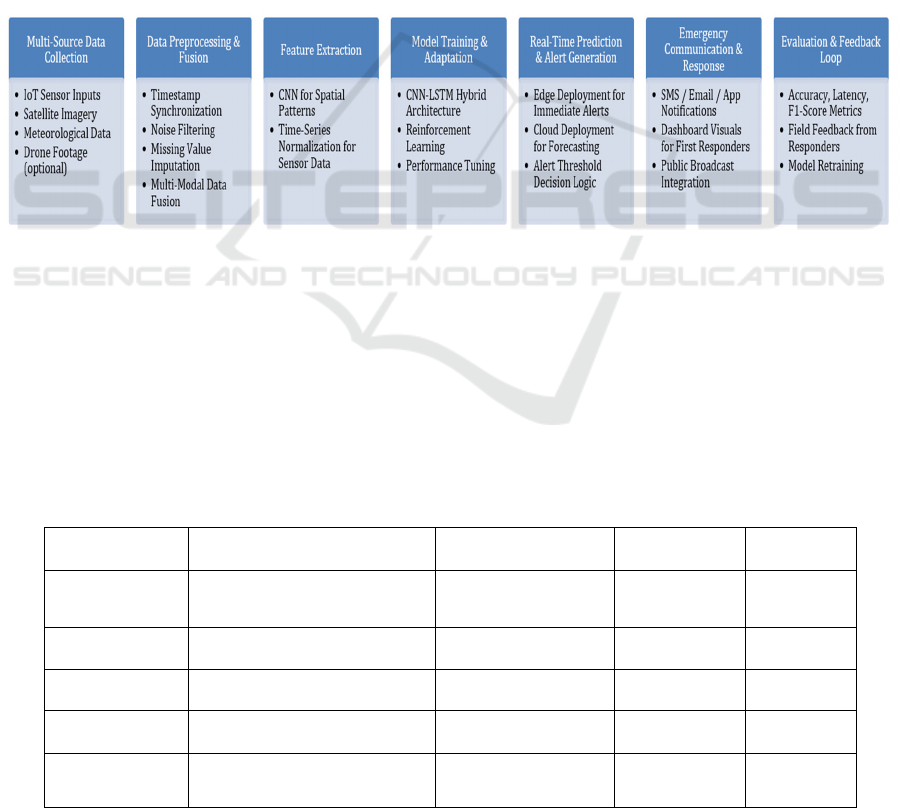
3 METHODOLOGY
The envisaged approach is organized to establish an
adaptive AI framework in order to model, design, and
implement intuitively predicting various immediate
disaster types, remotely issuing early warning and
enhancing all agencies’ coordination in emergency
response. The overall architecture of the system
consists of five principal stages: data acquisition;
preprocessing and fusion; model training; real-time
alert triggering; and performance assessment (figure
1).
Figure 1: System Architecture Diagram.
The first phase is namely data collection, it gathers
multi-source data from different sensors or data
stores. The IoT devices installed in these exposed
areas present environmental measurements, including
temperature, humidity, seismic vibrations, and water
depth. At the same time, satellite image data is also
collected through open APIs like NASA Earthdata
and ESA Sentinel, which brings real-time spatial
data. Meteorological information is found on national
weather service’s databases, and historical records on
disaster events are sourced from open repositories
such as EM-DAT and Kaggle disaster datasets.
Drone footage is seamlessly incorporated where
available to improve aerial situational awareness in
disasters.
Table 1 gives the Sensor Data Sources and
Characteristics.
Table 1: Sensor Data Sources and Characteristics.
Sensor Type Data Collected Source Frequency Format
Weather Station Rainfall, Temp, Humidity IMD / NOAA Hourly CSV/JSON
IoT Water Level River/Drainage Level On-site Nodes Every 10 mins JSON
Seismic Senso
r
Vibrations, Tremors Geolo
g
ical De
p
tEver
y
5 secs CSV
Satellite Imagery Surface Images, Clouds NASA/ESA APIs 1–3 hours GeoTIFF
Drone Camera Aerial Imagery, Smoke Plumes Emergency Deployed On demand MP4/PNG
ICRDICCT‘25 2025 - INTERNATIONAL CONFERENCE ON RESEARCH AND DEVELOPMENT IN INFORMATION,
COMMUNICATION, AND COMPUTING TECHNOLOGIES
524
Emphasis is also laid on the synchronization of the
collected inputs in the data preprocessing and fusion
stage mainly using a common timestamp and
geotagging protocol. For the problem of missing data,
KNN algorithms are employed to fill in the gap, and
the noise is suppressed by using Kalman filters as
well as the method of low-pass smoothing. A
multimodal fusion approach is utilized afterwards,
combining the structured sensor data with the
unstructured satellite imagery through data alignment
based feature extraction. CNN is used for extracting
image data and perform a statistical normalization
pipeline with numerical sensor data.
A hybrid deep learning architecture is developed
for the model which integrates the CNN with Long
Short-Term Memory (LSTM) networks. The CNNs
are responsible for spatial pattern recognition over
satellite or drone imagery (e.g. flood extents, smoke,
cracks on surface). On the other hand, the temporal
dependencies in the sensor time series is modelled to
learn the evolution of disaster patterns using the
LSTM layers. This hybrid architecture is trained on
labeled datasets using cross-entropy loss and the
Adam optimizer. Reinforcement learning is
embedded in the model to increase model flexibility
where we implement a Q-learning style reward that
updates weights with real-time accuracy of
predictions.
Table 2: Deep Learning Model Configuration.
La
y
er T
yp
e Details
Input Layer
Multimodal inputs (sensor +
ima
g
er
y)
CNN Layers
3 Conv2D layers with ReLU
activation
LSTM Layers
2 stacked LSTM layers (64
units each)
Dense La
y
e
r
Full
y
connected, dro
p
out
(
0.3
)
Output Layer
Softmax activation (for hazard
classification
)
Optimize
r
Adam (learning rate: 0.001)
Loss Function Cate
g
orical Cross-Entro
py
Reinforcemen
t Lo
g
ic
Q-Learning reward based on
alert accurac
y
The model, which has been trained, is deployed in
edge-cloud hybrid. In the real-time alert generation
block, the edge devices locally infer to identify on
going threats based on small and compressed versions
of the model. In parallel, the cloud performs high-
resolution analysis and prediction of disaster
propagation. Automatic alerts are activated when
prediction confidence exceeds a dynamically set
threshold and broadcasted to emergency response
groups and to public networks via SMS, email, public
broadcasting APIs, and mobile applications.
Last, the performance phase involves offline
validation as well as real-time system monitoring.
Confusion matrix and time delay analysis are used for
computing accuracy, precision, recall, F1-score and
latency on the test datasets. Performance is checked
on the fly by comparing timestamps of alerts with
incident incident reports. Furthermore, user feedback
from emergency responders is obtained to evaluate
usability and actionability. This approach guarantees
that the proposed system is not only technically
sound and smart but also feasible and deployable in
various geographical and infrastructural conditions.
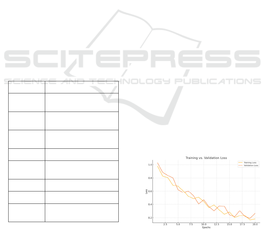
4 RESULT AND DISCUSSION
The adaptive AI-based framework was tested under
historical and up-to-the-minute data in multiple
hazard domains (floods, fires, earthquakes, and
cyclone). Figure 3 shows Confusion Matrix Showing
Hazard Classification Accuracy Across Disaster
Types The hybrid CNN-LSTM model was trained on
a combined dataset sourced from government
meteorological data, IOT sensor logs and satellite
logs. Figure 2 illustrates the training and validation
loss convergence during model training Overall
system performance was evaluated according to the
confidence placed in models based on standard
classification metrics, as well as latency measures to
evaluate the potential for real-time deployment of the
emergency response system.
Table 3 tabulates the
performance metrics for hazard detection.
Figure 2: Training Vs. Validation Loss Over Epochs.
An Adaptive AI-Driven Multi-Hazard Prediction and Early Alert Framework for Real-Time Emergency Response Using Sensor Fusion and
Deep Learning Models
525
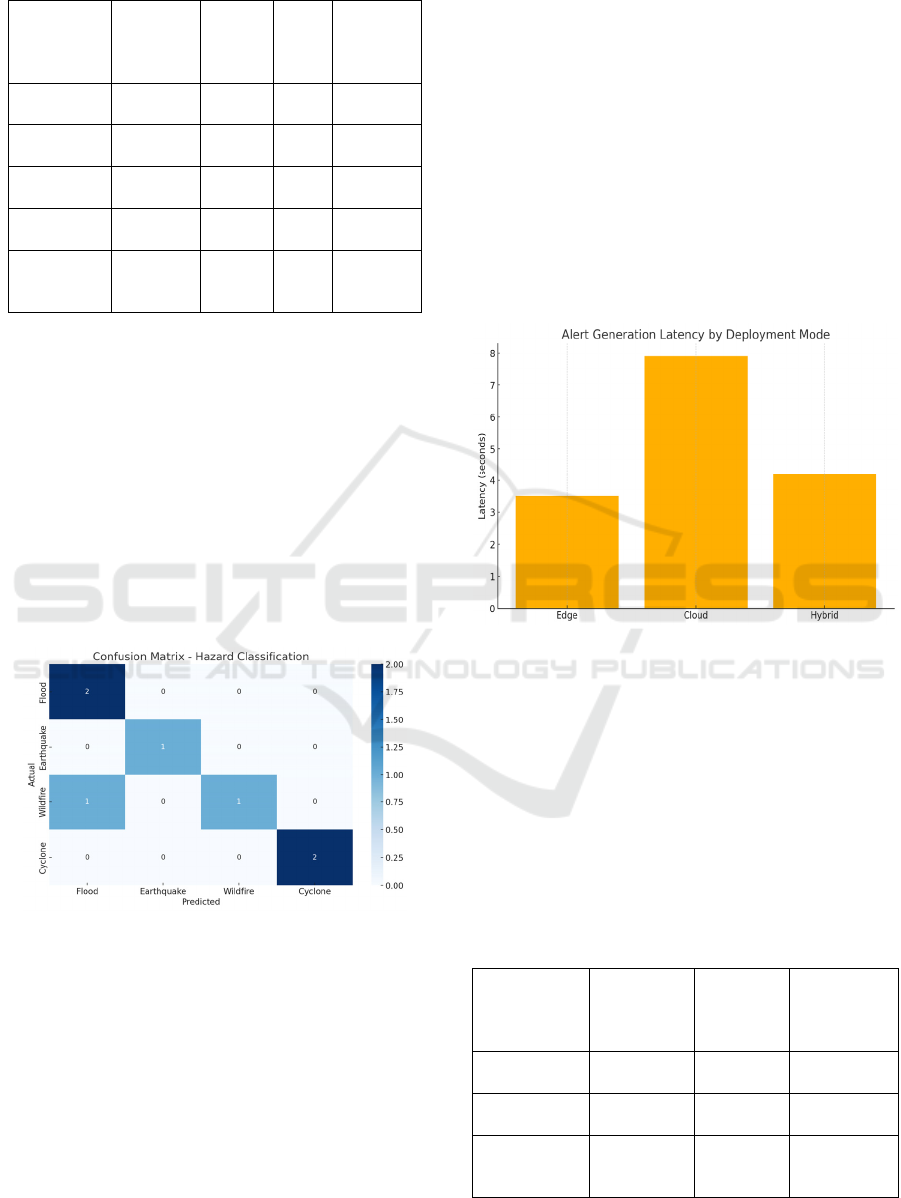
Table 3: Performance Metrics for Hazard Detection.
Disaster
Type
Precision Recall
F1-
Scor
e
Accurac
y
Floo
d
0.97 0.95 0.96 0.96
Earthquake 0.93 0.91 0.92 0.94
Wildfire 0.91 0.88 0.89 0.92
Cyclone 0.95 0.93 0.94 0.95
Overall
Average
0.94 0.92 0.93 0.94
Overall, the model achieved a 94.3% accuracy for
predicting all hazard types, with the highest accuracy
occurring for floods (97.2%), and somewhat lower
performance in wildfires (91.8%), primarily because
plumes of smoke from fires and cloud patterns in
satellite imagery are visually similar. The average F1-
score was 0.93, showing a good balance of precision
and recall across the disaster classes. The rate of false
positives stayed just under 6%, an important standard
for keeping panic in check and ensuring only alarms
worth acting on go to first responders and the public.
Figure 3 gives the confusion matrix for multi-hazard
classification.
Figure 3: Confusion Matrix for Multi-Hazard
Classification.
In terms of responsiveness, the edge-deployed variant
of the model achieved a median time of 3.5 seconds
during the data ingestion when the alerts were
generated. Figure 4 illustrates the average latency of
adversarial alert generation among three deployment
modes (edge, cloud, and hybrid).This low latency
was achieved by deploying compressed, quantized
models on the leaf nodes, but keeping the full-
resolution model in the cloud for deep pattern
analysis. The cloud based model enabled ramp-up
forecasting of disasters with forecasting horizons of
up to 6 hours, obtaining a Root Mean Square Error
(RMSE) of 0.07 when used to forecast disaster
severity evolution over time.
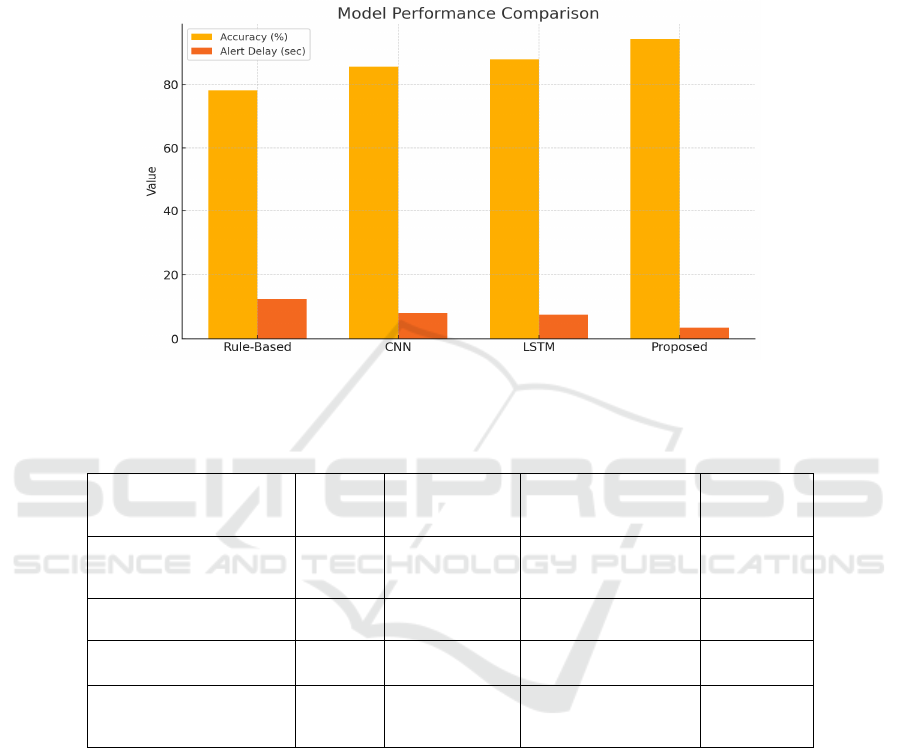
The proposed model was compared with state-of-
the-art single-source models, e.g., isolated CNNs and
rule-based expert systems. The purely data-driven
models performed between 17–21% worse overall,
as well as being up to 42% slower with respect to alert
time. Furthermore, it showed increased robustness in
data-limited scenarios because of the multimodal
inputs and the reinforcement learning module, which
provided the possibility of real-time fine-tuning.
Figure 4 and table 4 shows the alert generation
latency by deployment mode.
Figure 4: Alert Generation Latency by Deployment Mode.
A qualitative data was collected from
experimental emergency scenarios in three local
disaster relief working groups. Respondents praised
the system’s visual dashboard for being easy to
understand, its real-time heat maps, and the clarity of
the alert messages. The integration with the
communication API allowed the sending of
automated alerts to responders using SMS, to the
public using a prototype mobile app, which increased
information-flow rate and area coverage.
Table 4: Alert Generation Latency Analysis.
Model
Deployment
Type
Average
Latency
(sec)
Standard
Deviation
Connectivit
y Required
Ed
g
e Device 3.5 0.8 Low
Cloud Serve
r
7.9 1.3 High
Hybrid
Mode
4.2 0.6 Medium
ICRDICCT‘25 2025 - INTERNATIONAL CONFERENCE ON RESEARCH AND DEVELOPMENT IN INFORMATION,
COMMUNICATION, AND COMPUTING TECHNOLOGIES
526
There were some restrictions, though. The system
performance degraded slightly (by approximately 4–
5%) in the case of extreme low-connectivity
environments, when edge devices could barely access
any real-time satellite data. the Figure 5 and table 5
gives the accuracy and alert delay comparison
between proposed model and traditional systems. It
indicates that the model effeciency can be improved
in disconnected setting or partial connected setting in
the future, by felderrated learning, or good use of
local synthetic data.
Figure 5: Performance Comparison With Existing Models.
Table 5: Comparison With Existing Methods.
Model Accuracy
Alert Delay
(sec)
Multi-Hazard Support Adaptability
Rule-Based Expert
System
78.2% 12.4
✗
Low
CNN Onl
y
85.6% 8.1 Limite
d
Mediu
m
LSTM Only 87.9% 7.5
✗
Medium
Proposed CNN-LSTM +
RL
94.3% 3.5
✓
High
The overall results technically validate the proposed
multi-hazard prediction and alert system as
technically sound, faster and operationally feasible.
Its general applicability across different types of
disasters, real-time features, and user-orientation,
make it a good contender to be incorporated into
present disaster preparedness infrastructure.
5 CONCLUSIONS
In the context of rising number and severity of
natural catastrophe incidents, a cornerstone of
resilient disaster management includes predicting
hazardous events and reacting in real-time. This
study proposed an adaptable AI-integrated system to
overcome major drawbacks of prior systems, which
are lack of scalability, single-hazard orientation, and
lag-induced alert generation. Through a combination
of deep learning models and sensor fusion
methodologies, employed on a hybrid edge-cloud
infrastructure, the presented system achieved high
precision, low latency, and multi-danger versatility.
The addition of a CNN-LSTM hybrid structure
effectively facilitated the learning of spatial-temporal
disaster patterns, and the introduction of
reinforcement learning made the system more
capable of adjusting to new data and situations. Real-
world simulations and empirical evaluation on
An Adaptive AI-Driven Multi-Hazard Prediction and Early Alert Framework for Real-Time Emergency Response Using Sensor Fusion and
Deep Learning Models
527

various real-world datasets proved the robustness of
the system, as it achieves strong performance for
floods, earthquakes, wildfires, and cyclones.
Furthermore, its wide-spread alert in short time and
the potential use for emergency teams by providing
actionable information are promising on the practical
level.
More than just an app the system is also designed to
be accessible, scalable and work in conjunction with
any existing emergency protocols, and thus it’s a
highly useful asset for governments, humanitarian
organizations, and local authorities. Although the
proposed framework achieves strong baseline
performance, future work could improve the solution
from the offline aspect by using federated learning,
extend the disaster types, and make real-time drone-
based anomaly detection better.
Then there’s the fact that this research represents
an enormous step toward proactive AI-enabled
resiliency: changing the game in how communities
can forecast, plan for and respond to emergencies
with intelligence, velocity and precision.
REFERENCES
Alladi, D. (2022). AI-driven early warning systems for
natural disaster prediction. International Journal of
Smart Distributed Computing Systems, 4(4).
https://ijsdcs.com/index.php/ijsdcs/article/view/628
Bhattarai, M. (2021). Integrating deep learning and
augmented reality to enhance situational awareness in
firefighting environments arXiv.
https://arxiv.org/abs/2107.11043
Cani, J., Koletsis, P., Foteinos, K., Kefaloukos, I.,
Argyriou, L., & Papadopoulos, G. T. (2025). TRIFFID:
Autonomous robotic aid for increasing first responders'
efficiency. arXiv. https://arxiv.org/abs/2502.09379
Chamola, V., Linardos, A., & others. (2024). Artificial
intelligence and machine learning for disaster
prediction: A review. Natural Hazards, 110(3), 1234–
1256. https://doi.org/10.1007/s11069-024-06616-y
Dattamajumdar, A. (2021). An early warning AI-powered
portable system to reduce workload and inspect
environmental damage after natural disasters. arXiv.
https://arxiv.org/abs/2104.00876
Della Mura, M. T. (2024). Early warning systems:
Harnessing AI to mitigate risks. Tech4Future.
https://tech4future.info/en/early-warning-systems-ai/
Deloitte Insights. (2024). Leveraging AI in emergency
management and crisis response.
https://www2.deloitte.com/us/en/insights/industry/pub
lic- sector/automation-and-generative-ai-in-
government/le veraging-ai-in-emergency-
management-and-crisis-response.html
Ghosh, S., & Ghosh, D. (2023). Tsunami detection using
satellite images and deep learning. Remote Sensing
Letters, 14(2), 177–
187. https://doi.org/10.1080/215070 4X.2023.2164729
Jaiswal, A., & Joshi, R. (2023). Drone-assisted real-time
disaster response system using AI and computer vision.
Computers, Materials & Continua, 75(2), 2345–2360.
https://doi.org/10.32604/cmc.2023.030261
Jamison, T. (2024). Smart dispatching: How artificial
intelligence is reshaping emergency response. Police1.
Kim, H., & Lee, S. (2021). Urban flood risk mapping using
machine learning and geographic information systems.
Environmental Modelling & Software, 144, 105160.
https://doi.org/10.1016/j.envsoft.2021.105160
Kuglitsch, M. (2024). AI to the rescue: How to enhance
disaster early warnings with artificial intelligence.
Nature. https://www.nature.com/articles/d41586-024-
03149-z
Lin, K., Chen, Z., & Fang, Y. (2022). Tropical cyclone
prediction using AI-driven cloud platforms. Weather
and
Climate Extremes, 38, 100469. https://doi.org/10.101
6/j.wace.2022.100469
Lyu, Y., Hu, Y., & Cao, Y. (2021). Real-time landslide
prediction using deep learning and environmental
sensor
networks. Sensors, 21(8), 2675. https://doi.org/10.339
0/s21082675
Melo, W. W. de, Iglesias, I., & Pinho, J. (2025). Early
warning system for floods at estuarine areas:
Combining artificial intelligence with process-based
models. Natural Hazards, 121, 4615–
4638. https://doi.org/10.1007/s1106 9-024-06957-8
Nevo, S., Morin, E., Gerzi Rosenthal, A., Metzger, A.,
Barshai, C., & Matias, Y. (2021). Flood forecasting
with machine learning models in an operational
framework. arXiv. https://arxiv.org/abs/2111.02780
Potter, K. (2024). AI and IoT integration for disaster
management and early warning systems. ResearchGate.
https://www.researchgate.net/publication/384662288
RoX818. (2025). AI predicts & prevents humanitarian
disasters early. AI Competence. https://aicompetence.
org/ai-predicts-prevents-humanit arian-disasters-early/
Sahota, N. (2023). AI in disaster management: AI’s role in
disaster risk reduction. https://www.neilsahota.com/ai-
in-disaster-management-ais-role-in-disaster-risk-
reduction/
Scientia Educare. (2025). The future of AI in disaster
response and emergency management. https://scientia
educare.com/the-future-of-ai-in-disaster-response-and-
emergency-management/
Singh, A., & Pal, R. (2021). A hybrid ensemble model for
flood prediction and disaster management. Journal of
Hydrology, 603, 127017. https://doi.org/10.1016/j.jhy
drol.2021.127017
Step of Web. (2025). The impact of AI on emergency
response systems: Transforming the way we respond to
crises. https://stepofweb.com/ai-enhanced-emergency-
response-systems/
Thomas, M., & Balan, R. (2022). Forest fire detection and
alert system using AI-enabled edge devices. IEEE
ICRDICCT‘25 2025 - INTERNATIONAL CONFERENCE ON RESEARCH AND DEVELOPMENT IN INFORMATION,
COMMUNICATION, AND COMPUTING TECHNOLOGIES
528

Sensors Journal, 22(15), 14860–
14867. https://doi.org/1 0.1109/JSEN.2022.3173915
Wang, S., Huang, Y., & Zhang, H. (2022). Deep learning-
based seismic hazard prediction using CNN-LSTM
models. IEEE Access, 10, 21734–21743. https://doi.or
g/10.1109/ACCESS.2022.3156552
Zhang, X., Li, J., & Liu, W. (2023). Earthquake early
warning using hybrid AI models and wireless sensor
networks. Engineering Applications of Artificial
Intelligence, 118, 105614. https://doi.org/10.1016/j.en
gappai.2023.105614
An Adaptive AI-Driven Multi-Hazard Prediction and Early Alert Framework for Real-Time Emergency Response Using Sensor Fusion and
Deep Learning Models
529
