
Place Recognition with Omnidirectional Imaging and Confidence-Based
Late Fusion
Marcos Alfaro
1 a
, Juan Jos
´
e Cabrera
1 b
, Enrique Heredia
1 c
, Oscar Reinoso
1,2 d
,
Arturo Gil
1 e
and Luis Paya
1,2 f
1
Research Institute for Engineering (I3E), Miguel Hern
´
andez University, Elche, Spain
2
Valencian Graduate School and Research Network of Artificial Intelligence, Valencia, Spain
Keywords:
Mobile Robotics, Place Recognition, Omnidirectional Cameras, Deep Learning, Late Fusion.
Abstract:
Place recognition is crucial for the safe navigation of mobile robots. Vision sensors are an effective solution to
address this task due to their versatility and low cost, but the images are sensitive to changes in environmental
conditions. Multi-modal approaches can overcome this limitation, but the integration of different sensors often
leads to larger computing and hardware costs. Consequently, this paper proposes enhancing omnidirectional
views with additional features derived from them. First, feature maps are extracted from the original omnidi-
rectional images. Second, each feature map is processed by an independent deep network and embedded into a
descriptor. Finally, embeddings are merged by means of a late approach that weights each feature according to
the confidence in the prediction of the networks. The experiments conducted in indoor and outdoor scenarios
revealed that the proposed method consistently improves the performance across different environments and
lighting conditions, presenting itself as a precise, cost-effective solution for place recognition. The code is
available at the project website: https://github.com/MarcosAlfaro/VPR LF VisualFeatures.
1 INTRODUCTION
Robust and reliable localization is a cornerstone of
autonomous systems, enabling mobile robots and au-
tonomous vehicles to navigate complex environments
safely and efficiently (Liu et al., 2024). In this con-
text, Visual Place Recognition (VPR) consists in iden-
tifying the current location of a robot by matching the
view captured by an onboard camera against a pre-
existing map of visual landmarks. The recent success
of deep learning, particularly with architectures like
Convolutional Neural Networks (CNNs) and Vision
Transformers (ViTs), has led to significant advance-
ments in learning discriminative image descriptors for
this task (Arandjelovic et al., 2016; Dosovitskiy et al.,
2020). While these methods demonstrate high accu-
racy, they often exhibit a tendency to overfit, leading
to a narrow window of optimal performance.
a
https://orcid.org/0009-0008-8213-557X
b
https://orcid.org/0000-0002-7141-7802
c
https://orcid.org/0009-0001-7717-1428
d
https://orcid.org/0000-0002-1065-8944
e
https://orcid.org/0000-0001-7811-8955
f
https://orcid.org/0000-0002-3045-4316
Among vision sensors, omnidirectional cameras
are particularly advantageous for VPR. Their large
field of view (up to 360
◦
) provides comprehensive in-
formation about the robot’s surroundings, offering a
degree of inherent invariance to the robot’s orienta-
tion (Cabrera et al., 2021).
However, the use of omnidirectional images en-
tails significant challenges. First, these images suf-
fer from severe geometric distortions, which can de-
grade the performance of deep learning models typ-
ically trained with regular pin-hole (perspective) im-
ages. Second, like all vision-based methods, omnidi-
rectional VPR is highly susceptible to environmental
appearance changes caused by variations in lighting,
weather, and seasons, as well as perceptual aliasing,
where distinct locations appear visually similar.
A common strategy to overcome the limitations
of a single sensor modality is to fuse its data with in-
formation from other sensors, such as LiDAR. This
multi-modal approach leverages the strengths of each
sensor, for example, by combining the rich appear-
ance information from a camera with the geometric
precision of LiDAR to build more robust environmen-
tal representations (Yu et al., 2022). However, the in-
tegration of multiple sensor types increases the hard-
Alfaro, M., Cabrera, J. J., Heredia, E., Reinoso, O., Gil, A. and Paya, L.
Place Recognition with Omnidirectional Imaging and Confidence-Based Late Fusion.
DOI: 10.5220/0013743100003982
Paper published under CC license (CC BY-NC-ND 4.0)
In Proceedings of the 22nd International Conference on Informatics in Control, Automation and Robotics (ICINCO 2025) - Volume 1, pages 117-125
ISBN: 978-989-758-770-2; ISSN: 2184-2809
Proceedings Copyright © 2025 by SCITEPRESS – Science and Technology Publications, Lda.
117

ware and computational cost and system complexity,
which can be prohibitive for many robotic platforms.
This paper introduces an alternative paradigm: in-
stead of adding new sensor modalities, we propose to
use only one type of sensor (omnidirectional camera)
and enhance this visual information with additional
features. These features, which are less sensitive to
photometric variations than standard RGB channels,
are treated as independent information streams. They
are then integrated with the original image data us-
ing a novel, adaptive late fusion strategy. This fu-
sion mechanism operates as a weighted sum, where
the contribution of each feature stream is dynami-
cally determined by its confidence score during the
retrieval process. This allows the system to intelli-
gently rely on the most discriminative representation
for any given query.
Consequently, the proposed method adds the ro-
bustness of hand-crafted features to the high accuracy
and efficiency of CNNs for VPR, aiming for a both
accurate and robust solution for this task. Therefore,
the primary contributions of this work are twofold:
• We leverage some features derived from each
original image to increase the robustness against
challenging illumination and appearance varia-
tions that are common in real-world environ-
ments.
• We introduce a novel fusion technique that dy-
namically weights each feature stream based on
its retrieval confidence. This allows the model to
adaptively prioritize the most reliable information
source, significantly improving VPR accuracy un-
der challenging conditions.
The remainder of this manuscript is structured as
follows. Section 2 reviews the state of the art. In
Section 3, the proposed method is detailed. Section
4 describes the experiments. Finally, conclusions and
future work are discussed in Section 5.
2 RELATED WORK
2.1 Visual Place Recognition
The role of VPR is crucial for the safe localization and
navigation of mobile robots, and extensive research
has been performed in the design of new models and
techniques to address this task (Schubert et al., 2023).
Early approaches relied on hand-crafted features to
create global image descriptors but, with the rise
of artificial intelligence, deep networks are widely
employed currently as image encoders (Arandjelovic
et al., 2016; Oquab et al., 2023).
CNN-based models, such as CosPlace (Berton
et al., 2022) and EigenPlaces (Berton et al., 2023),
offer remarkable efficiency and accuracy. More re-
cently, ViTs have emerged as a powerful alterna-
tive, demonstrating exceptional performance due to
their ability to capture global context. However, their
complexity and data requirements often necessitate
sophisticated training strategies, such as the use of
adapters. Notable ViT-based models include Any-
Loc (Keetha et al., 2023), SALAD (Izquierdo and
Civera, 2024) and SelaVPR (Lu et al., 2024). Concur-
rently, innovations in feature aggregation have further
pushed the performance boundaries of both CNNs
and ViTs (Ali-Bey et al., 2023).
2.2 Data Fusion
In some occasions, mobile robots are equipped with
multiple exteroceptive sensors, whose data are fused
to reduce uncertainty and increase accuracy at VPR.
For instance, vision sensors are frequently combined
with LiDAR (Komorowski et al., 2021) and depth
(Finman et al., 2015), among others.
Concerning the stage in which feature fusion is
performed, these strategies are broadly divided into
early fusion, in which sensory information is fused
before being processed by a deep network (Heredia-
Aguado et al., 2025), middle fusion, in which sen-
sory data interact throughout the different layers of
the model (Liu et al., 2022), and late fusion, where the
different modalities are processed independently and
their respective descriptors are subsequently fused
(Komorowski et al., 2021).
Late fusion is commonly addressed with classical
methods, such as concatenation or addition, as they
achieve fairly competitive results in VPR. Also, there
are end-to-end methods which fuse embeddings from
different modalities through MLPs, but they usually
show lower performance than previous methods (Ko-
morowski et al., 2021). Besides, weighted sum is a
suitable option, but the fusion weights are often non-
dynamic and set empirically.
In this paper, a framework to enhance the visual
data with intrinsic features derived from the original
omnidirectional images is proposed. The visual data
and these intrinsic features are merged by means of a
late fusion approach that consists in a weighted sum,
where the fusion weights are dynamic and calculated
considering the confidence in the prediction of the
trained models. The aim of this method is to improve
the performance and robustness in VPR against chal-
lenging conditions while preserving a lightweight and
cost-effective solution.
ICINCO 2025 - 22nd International Conference on Informatics in Control, Automation and Robotics
118
3 METHODOLOGY
3.1 Omnidirectional Vision
Omnidirectional cameras are characterized by their
wide field of view, which enables the generation of
comprehensive image descriptors that are inherently
more robust to viewpoint variations. In this paper,
two distinct types of omnidirectional vision systems
are utilized to address VPR:
• Catadioptric system: This system comprises a
standard camera paired with a hyperbolic mirror.
It operates by capturing light rays that reflect off
the mirror’s surface towards the mirror’s focus,
where the camera’s optical center is positioned.
For our experiments, the resulting images were
unwarped into a panoramic format.
• 360
◦
camera: This type of sensor captures a full
spherical image, providing a 360
◦
field of view on
all axes. A key advantage of modern 360
◦
cam-
eras is their capacity for high-resolution imaging.
The spherical images captured by this camera are
processed using an equirectangular projection to
generate panoramic views.
3.2 Visual Features
While raw visual data are valuable for robotic scene
understanding, their reliability can be compromised
by challenges such as appearance variations (e.g.,
due to lighting or seasonal shifts) and visual alias-
ing. To mitigate these issues, we enhance the visual
information by extracting a set of fundamental fea-
tures from the omnidirectional images. These fea-
tures, described below, provide alternative represen-
tations of the scene. Figures 1 and 2 display exam-
ples of the feature maps generated from sample im-
ages Im(R,G,B).
• Intensity: Represents the brightness of each pixel
and is calculated as the average value of blue (B),
green (G) and red (R) color channels:
I =
R + G + B
3
. (1)
• Hue: Represents the pure color component of
each pixel. It is defined by the equation:
H = cos
−1
"
(R − G) + (R − B)
2
p
(R − G)
2
+ (R − B)(G − B)
#
.
(2)
• Gradient: Represents the intensity change in the
local neighborhood of a pixel. The gradient is
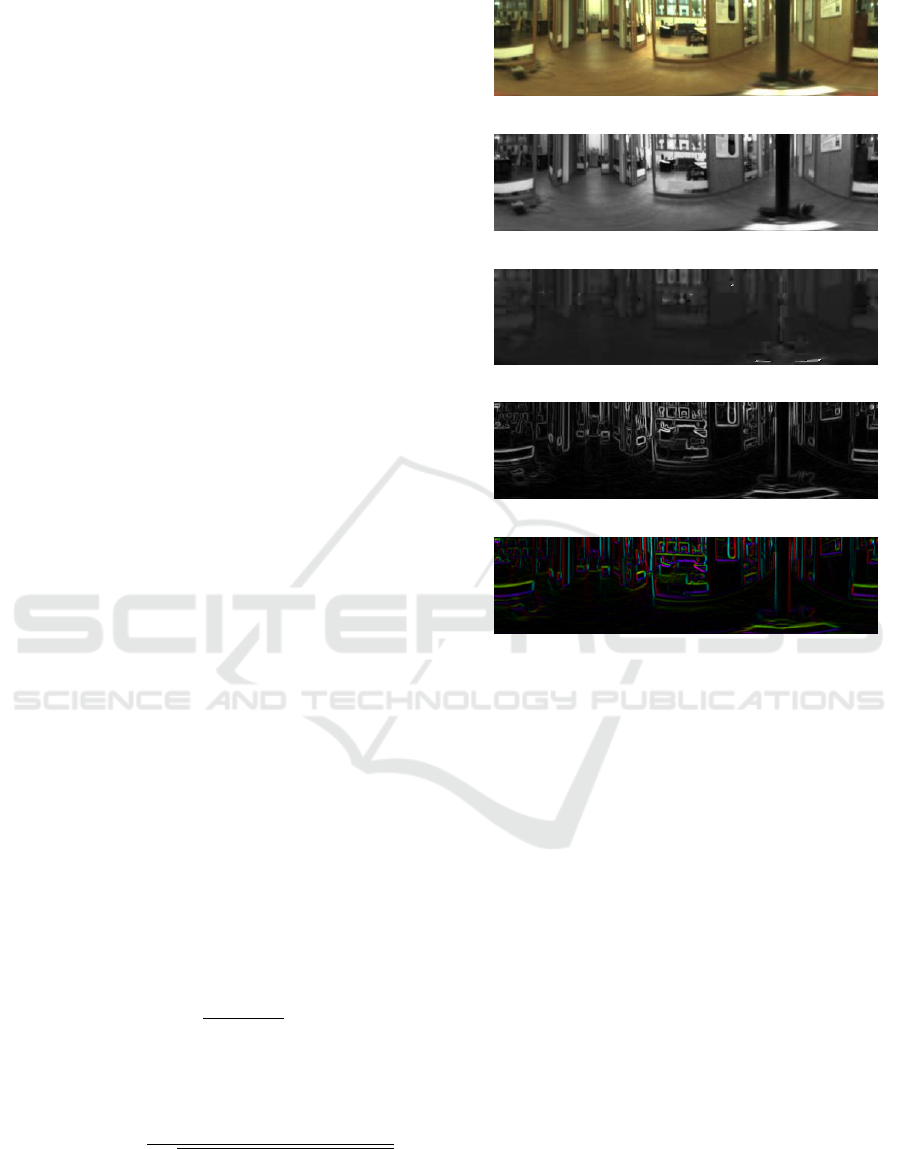
(a) Original
(b) Intensity
(c) Hue
(d) Gradient (Magnitude)
(e) Gradient (Orientation)
Figure 1: (a) Example of a panoramic image from the
COLD database (Pronobis and Caputo, 2009) and feature
maps obtained from the image: (b) intensity, (c) hue, (d)
gradient magnitude and (e) gradient orientation.
computed using Sobel operators, which are rep-
resented by the following convolution kernels for
the vertical and horizontal axes, respectively:
g
x
=
−1 −2 −1
0 0
∗
0
1 2 1
; g
y
=
−1 0 1
−2 0
∗
2
−1 0 1
.
(3)
From the Sobel responses ∆
x
= g
x
(Im) and ∆
y
=
g
y
(Im), two distinct features are derived:
– Magnitude: The gradient magnitude is calcu-
lated as the sum of the absolute intensity varia-
tions along both axes:
Mag =
|
∆x
|
+
|
∆y
|
. (4)
– Orientation: The gradient orientation is defined
as the direction of the maximum intensity vari-
ation and is given by:
θ = arctan 2 (∆y, ∆x) . (5)
Place Recognition with Omnidirectional Imaging and Confidence-Based Late Fusion
119
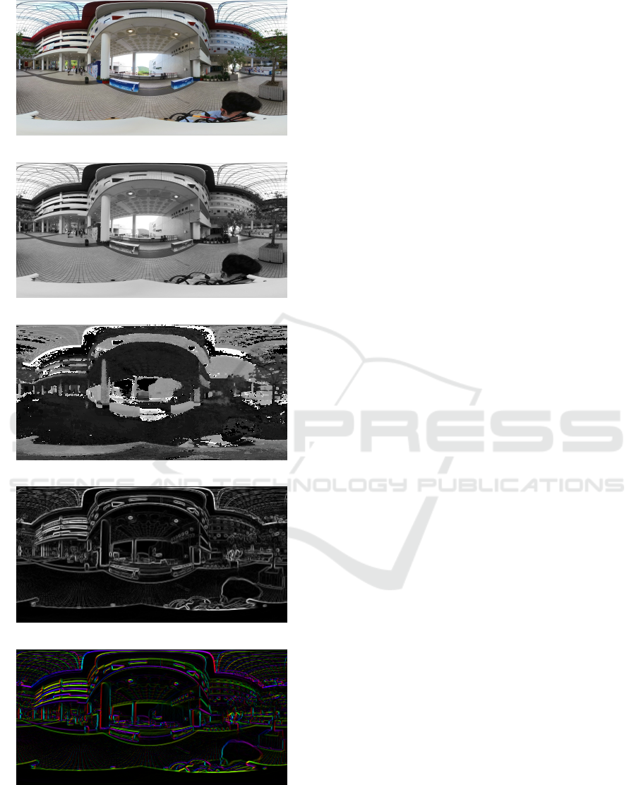
(a) Original
(b) Intensity
(c) Hue
(d) Gradient (Magnitude)
(e) Gradient (Orientation)
Figure 2: (a) Example of a panoramic image from the
360Loc database (Huang et al., 2024) and feature maps ob-
tained from the image: (b) intensity, (c) hue, (d) gradient
magnitude and (e) gradient orientation.
3.3 Data Fusion Approach
To create a more robust descriptor, information from
the raw images and the extracted features is combined
using a late fusion strategy. In this approach, each
input stream (e.g., RGB, Hue, etc.) is processed by
an independent neural network model to generate a
feature-specific descriptor. These individual descrip-
tors are then merged into a single, unified descriptor
through a dynamic weighted sum, as shown in the fol-
lowing equation:
⃗
d
q
= ω
RGB
∗
⃗
d
RGB
+ ω
I
∗
⃗
d
I
+ (6)
+ ω
Hue
∗
⃗
d
Hue
+ ω
Mag
∗
⃗
d
Mag
+ ω
θ
∗
⃗
d
θ
,
where
⃗
d
i
represents the descriptor for each feature
type and ω
i
is its corresponding weight. These
weights are calculated as detailed in Section 3.5.
3.4 Model Selection and Adaptation
To generate global descriptors from the omnidirec-
tional images and their feature maps, we employed
CosPlace (Berton et al., 2022), a state-of-the-art CNN
pre-trained on 41.2 millions of images for the VPR
task. From the available architectures, a comparative
evaluation is conducted in Section 4.3.1 to select the
optimal backbone for each database.
We adopted a transfer learning strategy, adapt-
ing the pre-trained model to process our specific in-
put types. For the single-channel feature maps, the
model’s input layer, originally designed for 3-channel
RGB images, was modified to accept a single-channel
input. The initial weights for this modified layer were
set by averaging the pre-trained weights of the orig-
inal R, G, and B input channels. The entire network
was then fine-tuned for each specific feature stream.
3.5 Training and Evaluation
During the training stage, an independent CosPlace
model was fine-tuned for each of the five input
streams: raw RGB images and the four derived visual
feature maps. A triplet architecture was employed,
which involves training the network with triplets of
images: an anchor (I
a
), a positive (I
p
) and a negative
(I
n
) sample, chosen in such a way that the distance
between the capture points of the anchor and the pos-
itive images must be lower than a threshold distance
r
p
, and the anchor and negative images must be cap-
tured further apart than a threshold distance r
n
, being
r
p
<= r
n
. The objective is to train the network to
produce similar descriptors for images captured from
ICINCO 2025 - 22nd International Conference on Informatics in Control, Automation and Robotics
120
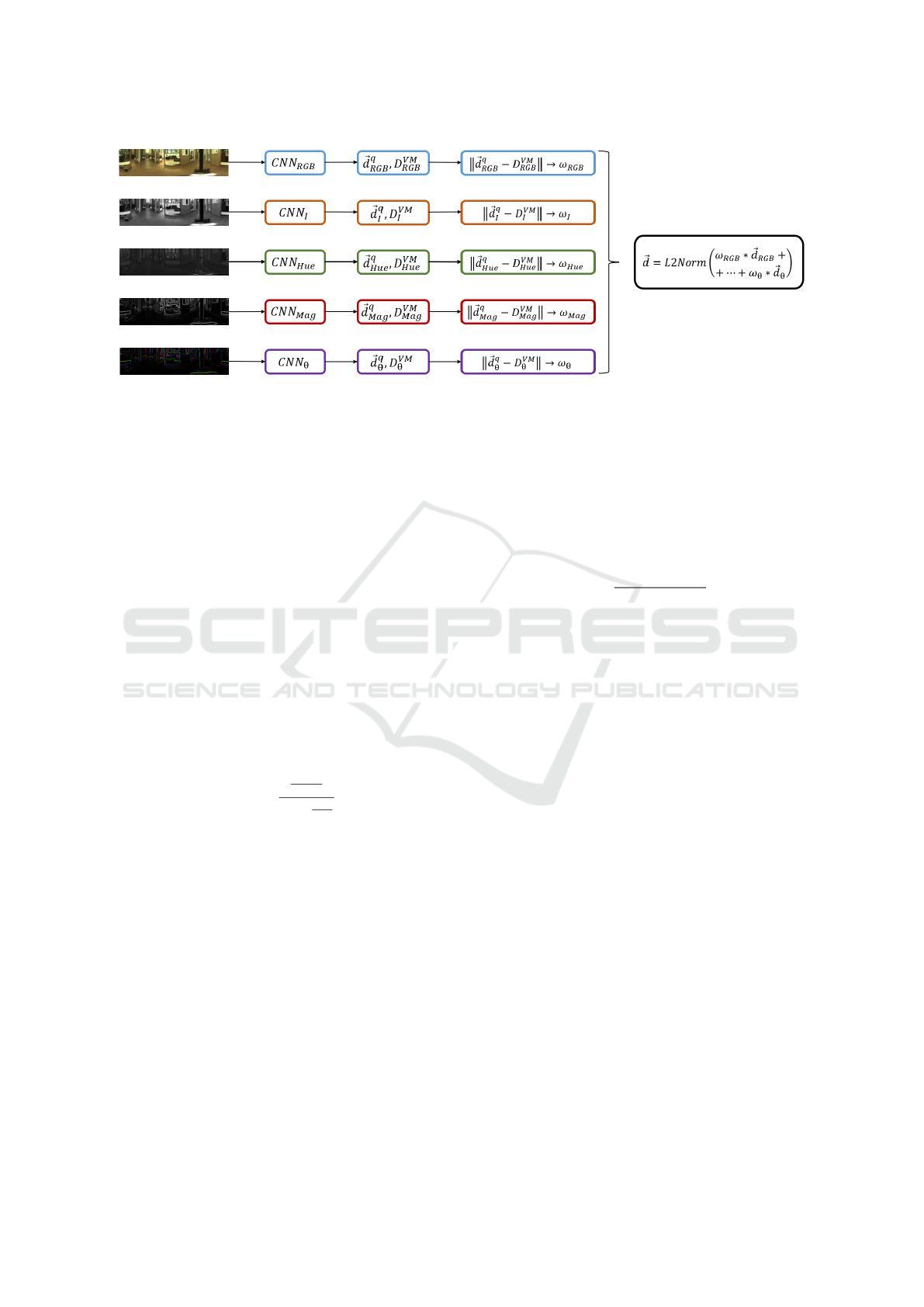
Figure 3: General outline of the proposed late fusion method.
close positions and dissimilar descriptors for images
of different places.
For evaluation, a global descriptor
⃗
d
q
is generated
for each image I
query
using the late fusion method out-
lined in Figure 3. The process is as follows:
1. For each feature stream k, the query image is
passed through its corresponding network (net
k
)
to produce a descriptor,
⃗
d
k
.
2. This descriptor
⃗
d
k
is compared against all the de-
scriptors in the database for that feature, D
V M
k
=
h
⃗
d
k
1
,...,
⃗
d
k
n
i
, using the Euclidean distance.
3. A confidence score, which serves as the fusion
weight ω
k
, is calculated. This weight rewards fea-
ture streams that produce a highly confident match
(i.e., the best-matching descriptor is significantly
closer than other descriptors in the database). The
weight is given by:
ω
k
=
1
dist
min
∑
n
i=1
1
dist
i
, (7)
where dist
min
is the smallest distance found in
Step 2, dist
i
is the distance between the query
descriptor and the i-th descriptor from the visual
model and n is the number of images from the vi-
sual model.
4. After repeating this process for all five feature
streams, the final fused query descriptor,
⃗
d
q
, is
calculated as the weighted sum of the individual
query descriptors using Equation 6.
Once the descriptor
⃗
d
q
is generated, it is compared
with the visual map D
V M
=
h
⃗
d
1
,...,
⃗
d
n
i
, where each
entry is a pre-computed descriptor also created as the
weighted average of the five feature descriptors for
that location. The minimum Euclidean distance in-
dicates the retrieved position in the map I
r
= (x
r
,y
r
).
The retrieval error, e
j
r
, for a given query j, is the geo-
metric distance between the ground-truth position of
the query image and the retrieved position.
To quantify the performance of our method, the
Recall@1 (R@1) metric is used. This measures the
percentage of query images that are correctly local-
ized within a specified threshold distance, d:
R@1(%) =
∑
M
j=1
I(e
j
r
≤ d)
M
× 100, (8)
where M is the number of images in the test set and
I(·) is the indicator function, which is 1 if the condi-
tion is true and 0 otherwise.
4 EXPERIMENTS
4.1 Datasets
To evaluate the proposed method under challenging
conditions, the experiments were conducted on two
distinct datasets: COLD and 360Loc, representing an
indoor environment and a mixed indoor-outdoor sce-
nario, respectively.
4.1.1 COLD
The COLD database (Pronobis and Caputo, 2009)
consists of panoramic images captured with a cata-
dioptric camera system across several indoor environ-
ments: Freiburg Part A (FR-A) and B (FR-B), and
Saarbr
¨
ucken Part A (SA-A) and B (SA-B). To eval-
uate the robustness to appearance changes, images
were captured under three different lighting condi-
tions: cloudy, night, and sunny. Table 1 details the
number of images used for the training and test sets.
Place Recognition with Omnidirectional Imaging and Confidence-Based Late Fusion
121
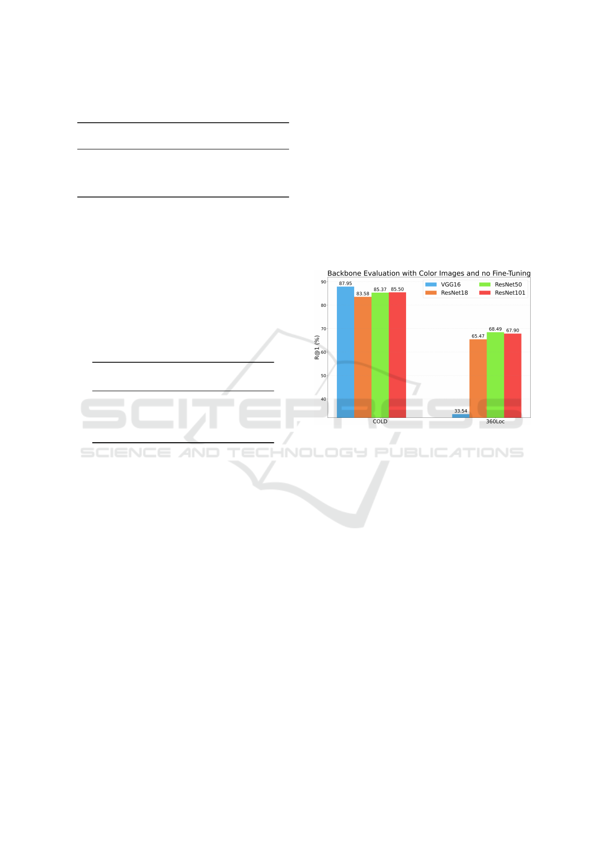
Table 1: Image sets employed for training and evaluation
from the COLD database.
∗
Training set.
Environment
Train/
Database
Test
Cloudy
Test
Night
Test
Sunny
FR-A 556
∗
2595 2707 2114
FR-B 560 2008 - 1797
SA-A 586 2774 2267 -
SA-B 321 836 870 872
4.1.2 360Loc
The 360Loc dataset (Huang et al., 2024) contains
high-resolution, equirectangular images captured in
four distinct semi-open locations: atrium, concourse,
hall, and piatrium. The images were collected under
day and night conditions, making the dataset suitable
for evaluating performance under severe lighting vari-
ations. Table 2 shows the number of images in the
training and test sets.
Table 2: Image sets employed for training and evaluation
from the 360Loc database.
∗
Training set.
Environment
Train /
Database
Test
Day
Test
Night
atrium 581
∗
875 1219
concourse 491 593 514
hall 540 1123 1061
piatrium 632 1008 697
4.2 Implementation Settings
To conduct the experiments, the Lazy Triplet Loss
(Uy and Lee, 2018) was employed, with a margin
m = 0.5 and a batch size N = 4, as it provided great
localization accuracy in similar works (Komorowski
et al., 2021). The selected optimizer algorithm was
the SGD (Stochastic Gradient Descent) with a learn-
ing rate lr = 0.001. All the experiments were per-
formed on an NVIDIA GeForce RTX 4080 SUPER
GPU with 16GB of memory.
Concerning the triplet sample selection during the
training process (see Section 3.5), r
p
and r
n
were both
set to 0.4m for the COLD database. For the 360Loc
database, r
p
and r
n
were set to 2m and 5m, respec-
tively. These values were chosen to perform a train-
ing with challenging and varied samples, considering
the number of training images and the dimensions of
the environments. Regarding the threshold distance d
to calculate R@1, d was set to 0.5m for the COLD
database, 5m for the concourse environment from the
360Loc dataset, and 10m for the rest of the environ-
ments of 360Loc, according to the criteria followed in
(Pronobis and Caputo, 2009) and (Huang et al., 2024).
4.3 Ablation Study
4.3.1 Backbone Selection
First, a preliminary experiment was conducted to se-
lect the optimal CNN backbone to embed the im-
ages and visual features into descriptors. All available
CosPlace models, i.e. VGG16, ResNet-18, ResNet-
50 and ResNet-101 were tested without training, with
a descriptor size of 512. Figure 4 displays the R@1
results obtained with each backbone on both the
COLD and 360Loc environments.
Figure 4: Backbone evaluation on both datasets.
As shown in Figure 4, since VGG16 and
ResNet50 produce the best results the best results for
indoor and outdoor experiments, respectively, they
have been employed in the subsequent experiments.
4.3.2 Feature Evaluation Before Fusion
Next, each visual feature is evaluated independently.
For this purpose, a separate model was fine-tuned and
tested for each of the five feature streams on both the
COLD and 360Loc datasets. The overall Recall@1
(R@1) for each feature is presented in Figure 5.
As shown in Figure 5, the model trained on the
original RGB images (baseline) achieved the high-
est performance. This result is expected, as the Cos-
Place model was pre-trained on standard color im-
ages. Nonetheless, the models trained on the intensity
and gradient magnitude features demonstrated com-
petitive performance across both datasets, validating
their potential as robust modalities for place recogni-
tion.
Besides, Figure 6 shows the average confidence in
the predictions of these models in the COLD Freiburg
environment. These results are separated into correct
and incorrect retrievals.
ICINCO 2025 - 22nd International Conference on Informatics in Control, Automation and Robotics
122
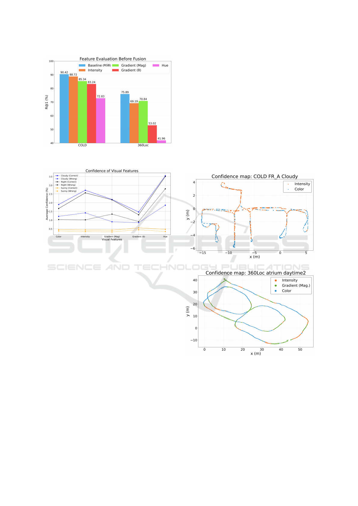
Figure 5: R@1 obtained by models trained with each visual
feature in both datasets.
Figure 6: Average confidence of models trained with each
visual feature in the COLD Freiburg A environment.
From Figure 6, it can be observed that, for every
feature, the model exhibits higher confidence when
it makes a correct retrieval. This supports the use of
the confidence to build descriptors that combine dif-
ferent visual features. It can also be noticed that the
model trained with hue shows the highest confidence
compared to the rest of features, even in wrong pre-
dictions. For this reason, besides its fairly low R@1,
hue is not a suitable feature for the proposed method.
4.3.3 Feature Evaluation after Fusion
Next, we evaluated the proposed late fusion approach
by combining the baseline RGB model with the other
visual feature streams. Several combinations were
tested to identify the most effective fusion strategy
across different scenarios and lighting conditions. Ta-
bles 3 and 4 present the detailed R@1 scores on the
COLD and 360Loc datasets, respectively.
On the indoor COLD dataset (Table 3), the best
global performance was achieved by employing the
baseline RGB model along with the intensity feature.
On the mixed-environment 360Loc dataset (Table
4), combining RGB with both intensity and gradient
magnitude (I + Mag) produced the largest improve-
ment, achieving a global R@1 of 80.29%, a +4.40%
increase in performance compared to the baseline.
Notably, the combination of intensity and gradient
magnitude also demonstrated highly competitive per-
formance under the most challenging lighting condi-
tions, such as sunny for the indoor dataset and night
for the outdoor dataset, where traditional color-based
methods often struggle.
To better understand how different features con-
tribute to localization, Figure 7 displays the feature
that dominated the fusion process for different query
images. On these maps, each point marks the location
of a query image. The color indicates which feature
yielded the highest confidence (ω
k
) for that query. A
dot · signifies a successful localization (retrieval error
≤ d), while a cross (×) denotes a failure.
(a)
(b)
Figure 7: Confidence maps for (a) COLD (FR-A cloudy)
and (b) 360Loc (atrium daytime).
4.3.4 Comparison of Late Fusion Methods
Finally, we benchmarked our proposed confidence-
based late fusion method against other conventional
fusion techniques. For this comparison, we used
the best-performing feature combination identified for
Place Recognition with Omnidirectional Imaging and Confidence-Based Late Fusion
123
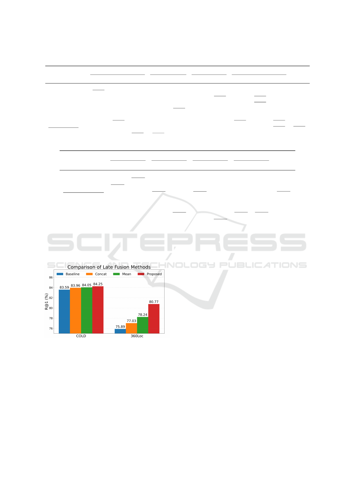
Table 3: R@1 after late fusion in the COLD database at every environment and lighting condition.
Features
FR-A FR-B SA-A SA-B
Global
Cloudy Night Sunny Cloudy Sunny Cloudy Night Cloudy Night Sunny
Baseline (RGB) 92.91 95.01 83.35 85.86 85.92 76.74 64.31 88.35 78.51 83.94 83.59
+Intensity (I) 93.10 95.27 83.82 85.31 89.59 76.74 63.21 91.99 78.74 84.75 84.25
+Gradient (Mag) 91.48 95.20 84.72 84.56 91.04 75.29 60.65 89.47 78.74 83.72 83.49
+Gradient (θ) 91.64 94.98 82.12 84.41 93.21 74.93 50.64 83.73 80.00 81.88 81.75
+Hue 91.52 94.42 74.55 86.10 73.34 74.67 35.33 88.88 72.53 81.08 77.24
+I + Mag 92.72 95.38 84.39 84.36 92.21 75.51 61.18 90.19 78.62 84.98 83.95
+All \wo Hue 92.18 95.71 87.51 85.61 94.10 75.77 59.15 88.52 78.05 84.98 84.16
+All 92.22 95.16 85.48 85.91 92.82 75.42 51.08 90.07 76.44 85.67 83.06
Table 4: R@1 after late fusion in the 360Loc database at every environment and lighting condition.
Features
atrium concourse hall piatrium
Global
Day Night Day Night Day Night Day Night
Baseline (RGB) 94.62 73.58 88.46 73.35 91.00 54.51 85.99 45.62 75.89
+Intensity (I) 93.85 68.18 89.02 72.76 91.52 59.12 84.81 42.75 75.25
+Gradient (Mag) 93.05 67.91 90.37 79.96 92.67 63.35 84.47 47.92 77.46
+Gradient (θ) 89.71 65.29 87.85 73.15 90.47 49.70 78.00 28.26 70.30
+Hue 86.87 65.55 80.22 35.99 90.38 39.49 77.20 36.58 64.03
+I + Mag 92.50 67.16 90.88 79.38 91.97 69.75 85.24 47.20 80.29
+All \wo Hue 91.30 70.23 90.21 78.60 92.45 67.32 83.17 42.75 77.00
+All 91.30 74.73 88.85 77.43 93.21 66.32 80.47 42.18 76.81
each dataset (RGB +I for COLD, and RGB+I +Mag
for 360Loc).
Figure 8: Comparison of late fusion methods in both
datasets.
The results, presented in Figure 8, demonstrate
that the proposed method consistently outperforms
other techniques. The improvement is particularly
pronounced in the challenging outdoor scenarios of
360Loc, highlighting the effectiveness of dynamically
weighting feature streams based on model confidence.
5 CONCLUSIONS
In this manuscript, omnidirectional images are en-
riched with intrinsic visual features, such as the
intensity and gradient magnitude, to tackle place
recognition. These features are integrated through a
confidence-based late fusion framework.
Our experimental results show that this approach
consistently enhances VPR performance across di-
verse environments and lighting conditions. The
performance gain is particularly significant in out-
door scenarios, which are prone to severe appear-
ance changes. For indoor environments, fusing RGB
with intensity information has yielded the best results,
while a combination of intensity and gradient mag-
nitude proves most effective for the mixed indoor-
outdoor dataset. Crucially, our proposed dynamic fu-
sion method demonstrates superior performance com-
pared to conventional late fusion techniques.
Future works will focus on integrating additional
data modalities such as estimated depth or semantic
information, to further enrich the scene representa-
tion. Furthermore, we will study the use of attention
mechanisms to conduct this data fusion.
ICINCO 2025 - 22nd International Conference on Informatics in Control, Automation and Robotics
124

ACKNOWLEDGEMENTS
The Ministry of Science, Innovation and Universities
(Spain) has funded this work through FPU23/00587
(M. Alfaro) and FPU21/04969 (J.J. Cabrera). This
work is part of the projects PID2023-149575OB-
I00, funded by MICIU/AEI/10.13039/501100011033
and by FEDER UE, and CIPROM/2024/8, funded by
Generalitat Valenciana.
REFERENCES
Ali-Bey, A., Chaib-Draa, B., and Giguere, P. (2023).
MixVPR: Feature mixing for visual place recognition.
In Proceedings of the IEEE/CVF winter conference on
applications of computer vision, pages 2998–3007.
Arandjelovic, R., Gronat, P., Torii, A., Pajdla, T., and
Sivic, J. (2016). NetVLAD: CNN architecture for
weakly supervised place recognition. In Proceedings
of the IEEE conference on computer vision and pat-
tern recognition, pages 5297–5307.
Berton, G., Masone, C., and Caputo, B. (2022). Rethinking
visual geo-localization for large-scale applications. In
Proceedings of the IEEE/CVF Conference on Com-
puter Vision and Pattern Recognition, pages 4878–
4888.
Berton, G., Trivigno, G., Caputo, B., and Masone, C.
(2023). Eigenplaces: Training viewpoint robust mod-
els for visual place recognition. In Proceedings of the
IEEE/CVF International Conference on Computer Vi-
sion, pages 11080–11090.
Cabrera, J. J., Cebollada, S., Pay
´
a, L., Flores, M., and
Reinoso, O. (2021). A robust CNN training approach
to address hierarchical localization with omnidirec-
tional images. In ICINCO, pages 301–310.
Dosovitskiy, A., Beyer, L., Kolesnikov, A., Weissenborn,
D., Zhai, X., Unterthiner, T., Dehghani, M., Minderer,
M., Heigold, G., Gelly, S., et al. (2020). An image is
worth 16x16 words: Transformers for image recogni-
tion at scale. arXiv preprint arXiv:2010.11929.
Finman, R., Paull, L., and Leonard, J. J. (2015). Toward
object-based place recognition in dense rgb-d maps. In
ICRA Workshop Visual Place Recognition in Chang-
ing Environments, Seattle, WA, volume 76, page 480.
Heredia-Aguado, E., Cabrera, J. J., Jim
´
enez, L. M., Va-
liente, D., and Gil, A. (2025). Static early fusion tech-
niques for visible and thermal images to enhance con-
volutional neural network detection: A performance
analysis. Remote Sensing, 17(6).
Huang, H., Liu, C., Zhu, Y., Cheng, H., Braud, T., and Ye-
ung, S.-K. (2024). 360Loc: A dataset and benchmark
for omnidirectional visual localization with cross-
device queries. In Proceedings of the IEEE/CVF Con-
ference on Computer Vision and Pattern Recognition
(CVPR), pages 22314–22324.
Izquierdo, S. and Civera, J. (2024). Optimal transport ag-
gregation for visual place recognition. In Proceedings
of the IEEE/CVF Conference on Computer Vision and
Pattern Recognition, pages 17658–17668.
Keetha, N., Mishra, A., Karhade, J., Jatavallabhula, K. M.,
Scherer, S., Krishna, M., and Garg, S. (2023).
AnyLoc: Towards universal visual place recognition.
IEEE Robotics and Automation Letters, 9(2):1286–
1293.
Komorowski, J., Wysocza
´
nska, M., and Trzcinski, T.
(2021). MinkLoc++: LiDAR and monocular image
fusion for place recognition. In 2021 International
Joint Conference on Neural Networks (IJCNN), pages
1–8. IEEE.
Liu, W., Fei, J., and Zhu, Z. (2022). MFF-PR: Point cloud
and image multi-modal feature fusion for place recog-
nition. In 2022 IEEE International Symposium on
Mixed and Augmented Reality (ISMAR), pages 647–
655. IEEE.
Liu, Y., Wang, S., Xie, Y., Xiong, T., and Wu, M. (2024). A
review of sensing technologies for indoor autonomous
mobile robots. Sensors, 24(4):1222.
Lu, F., Zhang, L., Lan, X., Dong, S., Wang, Y., and Yuan,
C. (2024). Towards seamless adaptation of pre-trained
models for visual place recognition. arXiv preprint
arXiv:2402.14505.
Oquab, M., Darcet, T., Moutakanni, T., Vo, H., Szafraniec,
M., Khalidov, V., Fernandez, P., Haziza, D., Massa, F.,
El-Nouby, A., et al. (2023). DINOv2: Learning robust
visual features without supervision. arXiv preprint
arXiv:2304.07193.
Pronobis, A. and Caputo, B. (2009). COLD: The CoSy
localization database. The International Journal of
Robotics Research, 28(5):588–594.
Schubert, S., Neubert, P., Garg, S., Milford, M., and Fis-
cher, T. (2023). Visual place recognition: A tutorial
[tutorial]. IEEE Robotics & Automation Magazine,
31(3):139–153.
Uy, M. A. and Lee, G. H. (2018). PointNetVLAD: Deep
point cloud based retrieval for large-scale place recog-
nition. In Proceedings of the IEEE conference on
computer vision and pattern recognition, pages 4470–
4479.
Yu, X., Zhou, B., Chang, Z., Qian, K., and Fang, F. (2022).
MMDF: Multi-modal deep feature based place recog-
nition of mobile robots with applications on cross-
scene navigation. IEEE Robotics and Automation Let-
ters, 7(3):6742–6749.
Place Recognition with Omnidirectional Imaging and Confidence-Based Late Fusion
125
