
Evaluation Approaches for an Aggregated Meteorological Model
for Artillery Operations
Jan Ivan
a
, Viktor Vitoul
b
, Ladislav Potužák
c
, Jan Drábek
d
and Tomáš Havlík
e
Fire Support Department, University of Defence, Kounicova 65, Brno, Czech Republic
Keywords: Artillery, Fire Control, Knowledge Based System, Meteorology, Military, Synopsys, Tactile Sensor.
Abstract: This article presents a research initiative focused on developing innovative methods of meteorological
preparation for artillery units. The ongoing conflict in Ukraine has underscored the pivotal role of artillery for
both sides, with its effectiveness hinging on fire accuracy—requiring compensation for multiple variables
affecting projectile trajectory. Among these variables, meteorological conditions are paramount and have
traditionally been assessed via upper-atmosphere sounding. However, current methods are susceptible to
enemy interference, necessitating the autonomous acquisition of meteorological data by artillery units, even
under degraded operational conditions. This research project proposes the development of an integrated
predictive model that leverages historical meteorological data. Using this model, artillery units would be able
to independently generate meteorological insights, eliminating the need for complex atmospheric sounding
systems or reliance on external data sources. The article also outlines a proposed method for evaluating the
model’s effectiveness, based on the General Preparation procedure used in artillery fire control.
1 INTRODUCTION
Although some military theorists forecasted a gradual
decline in the tactical relevance of artillery,
contemporary conflict dynamics suggest otherwise.
The ongoing war in Ukraine clearly illustrates that
artillery remains a critical element of force projection,
ensuring sustained and effective fire support for
maneuver units. This reality invites a nuanced
assessment of artillery’s operational effectiveness,
which is increasingly tied to the integration of
supporting technologies and data streams that govern
precision targeting and fire planning.
In contrast to other combat support branches such
as air defence, engineering, or logistics artillery
represents one of the oldest and most continuously
evolving military capabilities. Its doctrinal functions
and technical applications have undergone multiple
transformations in response to changes in warfare,
a
https://orcid.org/0000-0002-6194-8482
b
https://orcid.org/0009-0000-3624-7986
c
https://orcid.org/0000-0002-0213-717X
d
https://orcid.org/0009-0005-4188-4193
e
https://orcid.org/0000-0002-6990-4302
battlefield requirements, and advancements in
weapon systems.
Fundamentally, artillery is designed to deliver fire
support defined as the provision of fire effects that
exceed the direct engagement capabilities of
supported units, particularly at extended ranges.
Within this framework, precision and reach emerge as
the essential factors underpinning artillery utility.
Consequently, most historical improvements in
artillery technology have centered around enhancing
these two attributes (Rolenec et al., 2021).
The present article builds upon prior research
presented at ICINCO 2023 (Ivan et al., 2023),
offering a significantly enriched contribution. This
paper proposes a new approach based on the
statistical processing of 20 years of historical
atmospheric sounding data from selected
meteorological stations, aimed at generating
predictive meteorological messages. The proposed
method is directly linked to artillery fire control and
includes a model evaluation using General
208
Ivan, J., Vitoul, V., Potužák, L. and Drábek, J.
Evaluation Approaches for an Aggregated Meteorological Model for Artillery Operations.
DOI: 10.5220/0013705000003982
Paper published under CC license (CC BY-NC-ND 4.0)
In Proceedings of the 22nd International Conference on Informatics in Control, Automation and Robotics (ICINCO 2025) - Volume 1, pages 208-218
ISBN: 978-989-758-770-2; ISSN: 2184-2809
Proceedings Copyright © 2025 by SCITEPRESS – Science and Technology Publications, Lda.

Preparation methodology. It deepens the theoretical
foundation, introduces a rigorous evaluation
methodology grounded in the General Preparation
procedure, and elaborates on spatial and temporal
model structuring relevant to complex operational
environments where data acquisition is compromised.
To fully understand how contemporary artillery
leverages meteorological information to improve fire
accuracy, it is necessary to examine the principles of
artillery fire control and the systematic integration of
atmospheric data within this process.
2 ARTILLERY FIRE CONTROL
Artillery represents a technically advanced and multi-
domain branch of the armed forces, characterized by
its demand for a wide spectrum of input data to
operate effectively. The artillery system can generally
be divided into four fundamental components:
weapon–ammunition subsystems, sensor units, fire
direction capabilities, and auxiliary or support
technologies.
At the forefront of the system are the effectors,
which are the terminal platforms responsible for
delivering kinetic effects. These include tube artillery
(howitzers and cannons), mortars, and multiple
launch rocket systems (MLRS). For these weapon
systems to function with the required precision, they
must be supplied with reliable firing data. This data
set comprises spatial orientation and position of the
firing unit, ballistic characteristics of the selected
ammunition, and environmental factors - primarily
meteorological conditions - that influence projectile
behavior during flight.
The computation and provision of this firing data
falls under the responsibility of fire direction centers.
These command nodes integrate data streams from
supporting assets and sensor systems to calculate
firing solutions. Sensors, which are critical for
observing impacts and facilitating corrections, may
include electro-optical devices, laser rangefinders,
radar systems, or UAV-mounted platforms. Their
purpose is to relay observed point-of-impact
information back to fire control units, enabling real-
time corrections.
Fire control itself forms the operational core of
artillery employment. It encompasses a coordinated
sequence of tasks: planning, fire mission allocation,
preparation, and direction of fires in alignment with
mission intent. The primary objective is to maximize
destructive or suppressive effects on designated
targets.
Artillery fire control is structured into two distinct
but interdependent domains:
Tactical fire control operates at the mission
planning level. It involves choosing the optimal firing
unit based on current battlefield conditions, logistical
status, ammunition availability, and the overall
tactical picture (Świętochowski, 2019). This layer
aligns artillery effects with maneuver elements and
broader operational goals.
Technical fire control deals with precise
adjustment of firing parameters. These include
calculations for azimuth, elevation, and propellant
settings based on weapon configuration, ballistic
tables, and environmental corrections (Blaha et al.,
2016). The process may be executed manually by
trained personnel or through automated means using
digital fire direction systems and ballistic software.
Depending on the level of technological integration,
technical fire control is categorized as either manual
(human-calculated) or automated (computer-
assisted).
3 METEOROLOGICAL
TECHNIQUES
Meteorological support constitutes an essential pillar
of effective artillery fire control and target
engagement procedures. The ballistic path of an
artillery projectile is inherently sensitive to a variety
of atmospheric parameters, which must be accurately
accounted for when generating firing solutions.
Without proper environmental compensation, the
likelihood of first-round target effects is significantly
reduced.
Although specific methodologies for integrating
meteorological data into fire control vary from
country to country, there is a common operational
consensus regarding the core atmospheric variables
that influence projectile trajectory. These typically
include:
air temperature;
air density;
air pressure;
air humidity;
wind speed and direction.
By incorporating real-time or highly relevant
meteorological inputs into the fire direction process,
artillery units gain the ability to engage targets
without the need for prior adjustment salvos. This
capability enhances operational tempo, supports rapid
fire missions, and contributes to achieving tactical
surprise, thereby increasing the lethality and
effectiveness of indirect fire (Němec et al., 2022).
Meteorological considerations also play a key
role in the operational mobility of artillery assets. The
Evaluation Approaches for an Aggregated Meteorological Model for Artillery Operations
209

selection and planning of movement corridors linking
concealment zones, firing positions, and logistical
resupply points must reflect not only tactical and
terrain-based factors but also prevailing and
forecasted weather conditions. Ensuring mobility,
safety, and minimal exposure during transit is
particularly critical in dynamic combat scenarios
where the tempo of operations requires fast and often
pre-programmed route selection for reconnaissance
vehicles, fire support platforms, and logistic convoys
(Nohel et al., 2019; 2022).
3.1 Ascertaining of Meteorological
Conditions
Meteorological conditions can be detected in
different ways. Currently, the most widely used
method is the upper air sounding of the atmosphere,
which is carried out by specialized artillery units.
In the conditions of the artillery of the Czech
Army, the upper air sounding of the atmosphere is
carried out using the newly developed PODTEO
vehicle. This vehicle consists of a modified wheeled
M65E19WM 4×4 LMV Chassis Cab complete
with a CL 35ARM PODTEO trailer (Fig. 1).
Figure 1: PODTEO vehicle.
PODTEO vehicle is equipped with:
meteorological computer Marwin MW32;
radiotheodolite RT20;
CG31 antenna set;
surface station MAWS201M Tacmet.
The operation of this vehicle is based on the
ability to perform the upper air sounding and surface
observations and measurements. Upper air sounding
is realized by releasing meteorological balloons filled
with hydrogen, on which Vaisala RS92- SGP, RS41-
SGP or RS92-D radiosondes are attached (Fig. 2).
These radiosondes transmit meteorological data
to the RT20 radiotheodolite (Fig. 3). Upper air
sounding can be characterized as the main
component, because its goal is to find out the
meteorological conditions at individual heights, in
which artillery shells fly, and thus it is possible to
accurately determine the influence of meteorological
conditions on the flight of the shell.
Figures 2 and 3: Radiosonde and radiotheodolite RT-20.
3.2 Meteorological Messages
Meteorological messages represent the fundamental
output derived from upper-atmosphere soundings,
providing artillery and other combat elements with
vital environmental parameters. These reports
encapsulate a variety of atmospheric metrics, such as
surface-level pressure, virtual temperature, ground-
level wind vectors, and aggregated indicators like
average air density and temperature gradients, wind
profiles across selected altitudinal bands, and other
parameters relevant to ballistic computations.
The structure of these messages follows a strict
alphanumeric coding scheme. Data are encoded into
specific two and multi-digit numeric groups, where
each digit within a group conveys a predefined
physical quantity or state. The group positions are
fixed within the message format, allowing the
decoding software or operator to reliably extract and
interpret environmental data from the positional
context of each number. The sequential arrangement
of these groups in the message further denotes the
type and relevance of each dataset.
In practical artillery application, several variants
of meteorological messages are in routine use, such
as Meteo 11, METCM, METGM, METB3, and
METBK, depending on national doctrine and
equipment. These formats are either directly
processed by automated fire control systems or
manually interpreted to derive necessary corrections
for computing firing parameters.
Having access to these encoded meteorological
datasets is essential to achieving first-round target
effects without requiring bracketing or correction
salvos. The operational ability to autonomously
produce and disseminate these reports is therefore
critical to preserving the initiative, enhancing the
element of surprise, and ensuring accurate and lethal
artillery engagement (Blaha et al., 2018).
ICINCO 2025 - 22nd International Conference on Informatics in Control, Automation and Robotics
210

3.3 Identified Downsides
Upper air sounding represents a well-established
technique for acquiring current atmospheric profiles
in proximity to deployed artillery assets. Its principal
advantage lies in the ability to collect real-time
meteorological parameters at the location of interest.
However, despite its operational utility, this method
exhibits several critical limitations that restrict its
broader application on the modern battlefield.
One of the key disadvantages is the limited spatial
validity of the collected data. Meteorological
information obtained via radiosonde release is highly
localized, making it less applicable for dispersed or
maneuvering fire units. Moreover, the method’s
reliance on active signal transmission exposes the
meteorological system to detection, geolocation, and
subsequent kinetic targeting by adversaries. This
vulnerability has been repeatedly observed in the
context of the Ukraine conflict, where hostile forces
prioritize the neutralization of meteorological
capabilities to degrade artillery accuracy (Hrnčiar &
Kompan, 2023). These vulnerabilities have been
confirmed in operational scenarios where adversaries
employed electronic warfare and long-range fires to
suppress meteorological units, thereby degrading the
accuracy of artillery fire. This highlights the urgent
need for methods resilient to enemy interference,
including passive and autonomous solutions.
A further drawback stems from the logistical and
personnel dependencies associated with upper air
sounding. Radiosonde operations require specialized
hardware and trained operators. Any disruption—
whether through equipment failure, attrition, or
operational constraints—can render the
meteorological support function inoperable. The
absence of atmospheric correction data reduces the
effectiveness of artillery fire missions, increasing
ammunition expenditure and logistical strain—
factors that carry growing strategic weight in
prolonged high-intensity conflicts (Šlouf et al., 2023).
In response to these limitations, alternative data
sources have been explored, including the use of
gridded meteorological fields generated by the World
Area Forecast Center (WAFC). These datasets offer
broader spatial coverage and eliminate the need for
on-site radiosonde launches. However, the
geographic distance between WAFC sampling grids
and actual artillery positions can result in data
inaccuracies. Furthermore, in active conflict zones,
reliability of data transmission becomes problematic
due to adversarial electronic warfare capabilities.
A notable operational challenge lies in the
distribution of meteorological messages. In
contemporary conflicts such as that in Ukraine,
advanced electronic attack systems have
demonstrated the capacity to jam or intercept
electromagnetic signals. This affects both the uplink
from airborne sensors and the downstream
dissemination of WAFC products. Consequently,
reliance on transmission-based meteorological
support may prove untenable under degraded
conditions (Blaha & Brabcová, 2010).
Given these constraints, it becomes imperative to
explore passive, autonomous meteorological
solutions that are independent of real-time sensing
and communication. Such systems must be resilient
to electronic disruption and capable of supporting
artillery fire control even under conditions of partial
or total sensor denial.
4 EMERGENCY
METEOROLOGICAL DATA
PREPARATION PROJECT
Based on the analysis of the current situation and
findings from the war in Ukraine, two key facts
regarding the meteorological preparation of artillery
were identified. Specifically, it is the fact that
meteorological preparation continues to be an
absolutely necessary part providing key data for
artillery, without which it is not and will not be
possible to fire accurately in the future. The second
fact is that the current methods of obtaining
meteorological data have a number of shortcomings,
which can very easily cause the non-delivery of this
vital data for any reason.
Based on the evaluation of the current situation,
the research team defined a new project, called
Emergency METEO, whose goal is to ensure the
availability of meteorological data for the needs of
artillery fire control in case of degradation of the
capabilities of artillery meteorological units or other
sources from which artillery units obtain
meteorological data.
4.1 Overall Project Concept
Project is based on the previous research areas which
dealt with artillery survey and meteorological units
(Ivan et al., 2023; Ivan et al., 2022) The core objective
of the project revolves around achieving autonomous
generation of meteorological data and subsequent
creation of meteorological messages, eliminating the
dependency on traditional sounding methods.
Evaluation Approaches for an Aggregated Meteorological Model for Artillery Operations
211
Initially, the research team recognized the
potential for autonomously determining
meteorological data through their work with fire
control systems.
Some of these software tools enable the
generation of comprehensive reports for specific
climate zones and seasons, even in the absence of
actual meteorological messages. While deriving
firing data from such generated messages may
generally yield better results than relying solely on
basic tabular values, the margin of error can still be
significant, often necessitating subsequent fire
adjustments. Consequently, the practical feasibility of
this method is minimal, as it does not guarantee
accurate fire effectiveness.
In response, the research team proposed a more
detailed approach to generating meteorological data
based on spatial and temporal conditions. This
enhanced method aims to utilize a richer dataset to
produce meteorological messages with greater
precision, facilitating firing without the need for
subsequent adjustments.
The team identified historical data as the primary
information source to develop a predictive
(statistical) model for generating future
meteorological data (meteorological messages). The
initial phase of the research focuses on defining the
spatial and temporal scales required for the intended
predictive model. This step lays the groundwork for
subsequent model development and refinement.
4.2 Spatial Scale
In the introductory part, the intention is to create a
predictive model that would cover the entire territory
of the Czech Republic. In order to achieve this spatial
coverage, it will be necessary to obtain historical
meteorological data from the largest possible
portfolio of measuring stations, which would
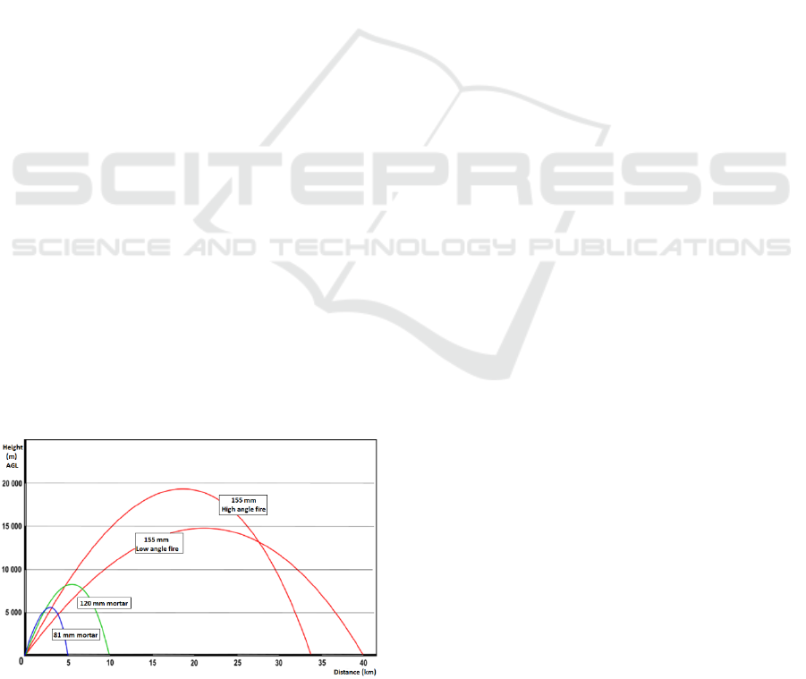
Figure 4: Maximum heights of artillery ammunition flight
path.
adequately cover the entire territory of the Czech
Republic. In this area, the first problematic aspect
arises regarding the requirements of artillery for
meteorological data and the resulting requirements
for character of sounding from a given measuring
station. One problematic part is the maximum height
from which meteorological data is collected.
The research project is primarily aim for the firing
of 155 mm effectors, which allow firing at distances
of up to 40 kilometers. As the distance increases, so
does the height that the shell reaches during flight,
and thus the height for which meteorological data
must be known. In the case of 155 mm effectors, it is
necessary to work with height parameters also related
to shooting at a high angle, when individual
projectiles reach greater heights than when shooting
at a low angle (Balon and Komenda, 2006).
According to the basic data on the height scale of
155 mm shells, it is therefore necessary that only
those stations that carried out upper air sounding of
the atmosphere up to a height of 20,000 meters AGL
are selected for the collection of historical data. (Fig.
4) The reason why this fact is problematic is that this
type of sounding is carried out by only a limited
number of meteorological stations on the territory of
the Czech Republic. With a smaller number of
meteorological stations, the coverage and therefore
the accuracy of the predictive model decreases. The
further away the place of application of the
aggregated meteorological data would be from the
meteorological station, the greater the error rate of the
predictive model will be.
It is this area that is a possible point of conflict on
which the research team plans to work so that it is
possible to find ways to also use data from
meteorological stations that carry out sounding, for
example by ground measurements or at lower
altitudes, which would increase the spatial coverage.
4.3 Temporal Scale
Another addressed area is the temporal scale for
which it will be possible to determine data from the
predictive model. As already mentioned, the artillery
needs to work with the most accurate data possible.
The intention of the research team is thus to prepare a
framework prediction of the meteorological situation
for individual days of the year, with the fact that this
general framework will be refined for sub-parts of the
given calendar day.
The output will be a predictive model within
which artillery specialists will be able to generate a
meteorological message for their position and a
specific part of the day of the year. Dividing the day
into individual time stages will be a separate area of
solution, because during the day we will find time
periods with higher weather stability and time periods
ICINCO 2025 - 22nd International Conference on Informatics in Control, Automation and Robotics
212

where changes occur (for example, sunrise and
sunset, noon, etc.).
4.4 Project Workflow
It is already clear that the creation of such a model
will take a large amount of time and work, as it will
primarily involve working with a large amount of
historical data, which must be analyzed, sorted and
aggregated into a predictive model that can be further
used in specific applications. The research team has
currently defined the successive steps of work on the
new project, which they would like to implement in
the short, medium and long-term horizon.
4.5 Phase 1 (Short Term Horizon)
The primary objective of the first phase is to assess
the feasibility and accuracy of the proposed
emergency determination of meteorological
messages. This involves verifying whether the
generated meteorological data accurately reflect the
conditions, particularly in terms of their
representation within meteorological messages.
During this initial phase, the predictive model will
focus solely on data from one measurement station,
specifically Prague, spanning a retrospective period
of 20 years. Prague was chosen due to its adherence
to initial requirements, including comprehensive
measurements up to maximum altitudes (30-35 km)
and data storage capabilities dating back to 1974.
However, for model creation, only data from the last
20 years will be utilized. At the Prague station,
atmospheric soundings occur thrice daily (at 0, 6, and
12 hours UTC), with additional soundings available
upon request.
The primary aim of this phase is to ascertain the
feasibility of creating an applicable predictive model
for artillery purposes, with a practical experiment
planned to validate the model's accuracy against real
upper air sounding data. Successful results will pave
the way for phase 2, while any shortcomings will
prompt critical analysis and refinement.
4.6 Phase 2 (MID Term Horizon)
If the predictive model proves effective, the research
will advance to the second phase, aimed at expanding
its applicability to the entire Czech Republic. This
phase poses significant challenges as the initial
model, developed in phase 1 for a single
meteorological station, must now be extended to
cover the entire country.
One major challenge involves analyzing and
processing meteorological data from multiple stations
across varied terrain. Aggregating the model to areas
beyond the source station requires careful
consideration of terrain variability, selection of
interpolation methods for height data, choice of
numerical models, and comparison of data from
multiple stations relative to firing positions.
The objective of this phase is to produce a
predictive meteorological model applicable across
the Czech Republic.
4.7 Phase 3 (Long Term Horizon)
The overarching goal of the research implementation
is to advance the utilization of meteorological data by
developing an enhanced version of a predictive
statistical model. This progressive model aims not
only to generate meteorological messages for specific
times within a day but also to forecast outlooks for the
upcoming hours, days, and even weeks.
The ultimate objective is to discern the trajectory
of meteorological patterns over time, enabling the
refinement of the predictive model to provide
increasingly accurate forecasts for various time
frames, ranging from hours to weeks ahead.
5 APPROACH TO MODEL
EVALUATION
Apart from the creation of the meteorological model,
it was necessary to define the method of its
evaluation. Considering that this is a meteorological
model initially defined for use with artillery units, the
methodology of its evaluation was defined following
its direct use in determining the firing data. For the
evaluation of the model, the evaluation method was
determined in the first phase in the sense of the
method of determining the firing data - specifically,
the General preparation of the firing data was chosen.
This method of determining the firing data was
chosen because it is a method in which the firing data
are determined for actual meteorological, ballistic and
geophysical influences. General preparation thus
applies all measurable effects of both the weapon and
the surrounding environment to the firing.
5.1 Phase 1 (Short Term Horizon)
General preparation is one of the main ways of firing
data preparation in the artillery of the Czech Army.
This method of firing data preparation is used, with
partial differences, by most of the artillery of various
armies around the world. The main purpose of the
general preparation is to determine all possible
measurable influences with effect on the artillery
Evaluation Approaches for an Aggregated Meteorological Model for Artillery Operations
213

shell and thereby changing its trajectory. Within
artillery, there are always defined tabular firing
conditions. If the real conditions are different, the
trajectory of the shell deviates. As part of the general
preparation, the main purpose is to find out the
changes in the real conditions compared to the tabular
values, and for these changes to clearly define the
variation in the trajectory of the shell in direction and
distance. The general preparation of firing data
generally works with three groups of effects causing
the variation of the trajectory of the shell for which it
determines the corresponding distance (ΔD) and
deflection (ΔS) corrections for meteorological,
ballistic and geophysical effects according to
equations (1) and (2).
∆D = ∆DM + ∆DB + ∆DG (1)
∆S = ∆SM + ∆SB + ∆SG (2)
Where:
∆𝐷 is total range correction for actual
conditions
∆𝑆 is total deflection correction for actual
conditions
∆𝐷𝑀/∆𝑆𝑀 is range (direction) correction for
changes in meteorological conditions
∆𝐷𝐵/∆𝑆𝐵 is range (direction) correction for
changes in ballistic conditions
∆𝐷𝐺/∆𝑆𝐺 is range (direction) correction for
changes in geophysical conditions
Meteorological Conditions.
Meteorological conditions include effects that affect
the distance and deflection of the firing after the shell
leaves the barrel. The influence of meteorological
conditions was sufficiently described in the previous
parts of this article. Changes in meteorological
conditions are obtained from the meteorological
message METEO 11. Using data from this
meteorological message distance corrections will be
calculated for the following influences (Equation 3):
change in ground air pressure at the altitude of
the firing position;
change in air temperature at standard
meteorological altitudes;
direction of ballistic wind;
ballistic wind speed.
∆DM = ∆D∆H + ∆D∆T + ∆D∆W (3)
Where:
∆𝐷𝑀 is range correction for changes in
meteorological conditions
∆𝐷∆𝐻 is range correction for change of
barometric pressure
∆𝐷∆𝑇 is range correction for change of air
temperature
∆𝐷∆𝑊 is range correction for range wind
As part of the calculation, the individual components
of the influences defined by equations (4) to (8) are
followed.
∆D∆H = ∆HB × 0,1 × ∆XH (4)
Where:
∆𝐷∆𝐻 is range correction for change of
barometric pressure
∆𝐻𝐵 is actual change of surface barometric
pressure
∆X𝐻 is unit range correction for barometric
pressure change of 10 Torr
The individual measured variables must be
expressed as a difference from the tabular values as
part of the calculation of total corrections in distance
and deflection. The exact difference values from the
tabular values are determined by the following
equations.
∆HMDP = H – 750 (5)
Where:
∆
𝐻𝑀𝐷𝑃 is change in surface barometric
pressure
H is actual barometric pressure in
altitude of meteorological unit
750 is tabular barometric pressure value
(750 Torr)
∆D∆T = ∆τ × 0,1 × ∆XT (6)
Where:
∆𝐷∆𝑇 is range correction for change of air
temperature
∆τ is actual change of air temperature in
selected altitude
∆X𝑇 is unit range correction for air
temperature change of 10 °C
∆T = T − 15,9 (7)
Where:
∆T is change in air pressure
T is actual air temperature in altitude of
meteorological unit
15,9 is tabular air temperature (15,9 °C)
∆Dwx = wx × 0,1 × ∆Xwx (8)
Where:
∆𝐷𝑤𝑥 is range correction for range wind
𝑤𝑥 is actual value of range wind
∆X𝑤𝑥 is tabular correction for range wind of
10 m.s-1
Using data from this METEO 11 meteorological
message, deflection corrections calculated for the
transverse component of the ballistic wind will be
determined (Equation 9)
ICINCO 2025 - 22nd International Conference on Informatics in Control, Automation and Robotics
214

∆SM = ∆SW (9)
Where:
∆𝑆𝑀 is total deflection correction for
changes in meteorological condition
∆𝑆𝑊 is deflection correction for cross wind
∆Sw = wz × 0,1 × ∆Zwz (10)
Where:
∆𝑆𝑤 is deflection correction for cross wind
𝑤𝑧 is actual crosswind value
∆Z𝑤𝑧 is tabular correction for cross wind of
10 m.s-1
Ballistic wind is a specific term that describes how
much wind, defined by direction and speed, affects
the flight of the shell. Depending on the direction in
which the ballistic wind affects the flight of the shell,
we decompose the range and cross wind vector. For
the distribution into individual vectors, it is first
necessary to determine the angle of wind according to
equation (5).
Aw = αS − αw (11)
Where:
𝐴𝑤 is angle of wind
α𝑆 is direction of fire
α𝑤 is direction of wind
Individual vectors are then determined according
to equations (6) and (7).
wx = w × cos Aw
(12)
wz = w × sin Aw
(13)
Where:
w𝑥 is actual value of range wind
w𝑧 is actual value of cross wind
w is actual value of wind speed
𝐴𝑤 is angle of wind
Ballistic conditions.
Ballistic firing conditions are determined during a
process known as ballistic preparation. Ballistic
conditions include those influences that affect the
distance and deflection of the firing and are active
mainly until the moment when the shell leaves the
barrel and partially also on the flight path of the shell.
Ballistic effects depend on the type and construction
of the effector and the type of used ammunition. For
the purposes of evaluating the meteorological model,
the firing data will be prepared for the standard
effector of the Army of the Czech Republic, namely
the 152mm SPG M-77 DANA.
The purpose of the ballistic preparation is to
determine the changes in the ballistic characteristics
of the effector and ammunition against the tabular
values. Based on the identified changes from the
tabular values, distance and direction corrections for
ballistic firing conditions are then prepared
(Equations 14 and 15).
∆DB = ∆Dv0 + ∆DCT + ∆
DCh + ∆DCol (14)
Where:
∆𝐷𝐵 is total range correction for changes in
ballistic conditions
∆𝐷𝑣0 is range correction for change in
muzzle velocity
∆𝐷𝐶𝑇 is range correction for change in
charge temperature
∆𝐷𝐶ℎ is range correction for change in used
charge type
∆𝐷𝐶𝑜𝑙 is range correction for change in
unpainted shell body
For the evaluation of the proposed meteorological
model, all ballistic effects listed above will be
evaluated as tabular. This solution was chosen in
order to distance and deflection corrections caused by
changing meteorological conditions stand out clearly.
Simply said, the values inserted into equation (14)
will be zero.
In the case of direction correction, the only
influence considered is spin drift, which is the lateral
(directional) deviation of the shell caused by the
rotation of the shell (Equation 15). This phenomenon
is caused by rotational stabilization, which helps to
direct and thus improve the accuracy of the shell's
flight. The rotational movement is given to the shell
by the bore of the barrel. Spin drift is thus a
phenomenon that manifests itself in all guns with a
grooved barrel bore. It is obvious that this
phenomenon is negligible for small caliber weapons.
However, with increasing firing distance, the lateral
deviation of the shell increases, and if the firing was
not compensated for spin drift, the target would not
be hit. This is especially evident with artillery
weapons, which can fire at a distance of several
dozens of kilometers.
∆SB = Z (15)
Where:
∆𝑆𝐵 is total deflection correction for
change in ballistic conditions
𝑍 is tabular deflection correction for spin
drift
Spin drift values are clearly defined in the firing
tables for each distance, and it is thus possible to
quantify them precisely. Unlike ballistic influences
affecting the distance, the spin drift will not be zero,
but will correspond to precisely selected distances.
Evaluation Approaches for an Aggregated Meteorological Model for Artillery Operations
215
Geophysical Conditions.
Geophysical conditions can have a large effect on the
direction of artillery fire. In particular, the direction
and speed of the Earth's rotation have significant
consequences for the artillery fires.
A crucial variable is the Coriolis Effect: Due to
the Earth's rotation, a shell moving on the Earth's
surface has an apparent deflection due to the Coriolis
Effect. This effect is caused by a combination of the
Earth's rotation and the forward motion of the shell.
In the Northern Hemisphere, the influence of the
Coriolis effect is such that shells seem to deflect to
the right, while in the Southern Hemisphere the
deflection is to the left. This variation is most
noticeable with long-range shells or shells fired on
long distances.
Another necessary variable is the speed of the
Earth's rotation. The speed of the Earth's rotation also
affects artillery fire, especially when it comes to
variations caused by the Corio-press effect. At
locations with a higher rotational speed of the Earth,
such as the equator, the deviations caused by the
Coriolis effect are more significant than at locations
with a lower rotational speed, such as the poles.
Consider these geophysical phenomena is
necessary for accurate calculation of firing data and
effective target engagement, especially in long
distances fires or in different geographical areas. The
rules of firing and fire control in the Czech Army
assess the geophysical effects during artillery fire at
distances of less than 25 km as negligible. Due to the
fact that for the evaluation of the model, the effector
will be 152mm SPG M-77 DANA, whose maximum
range is around 20 kilometers, geophysical influences
will be considered as zero for the evaluation of the
meteorological model.
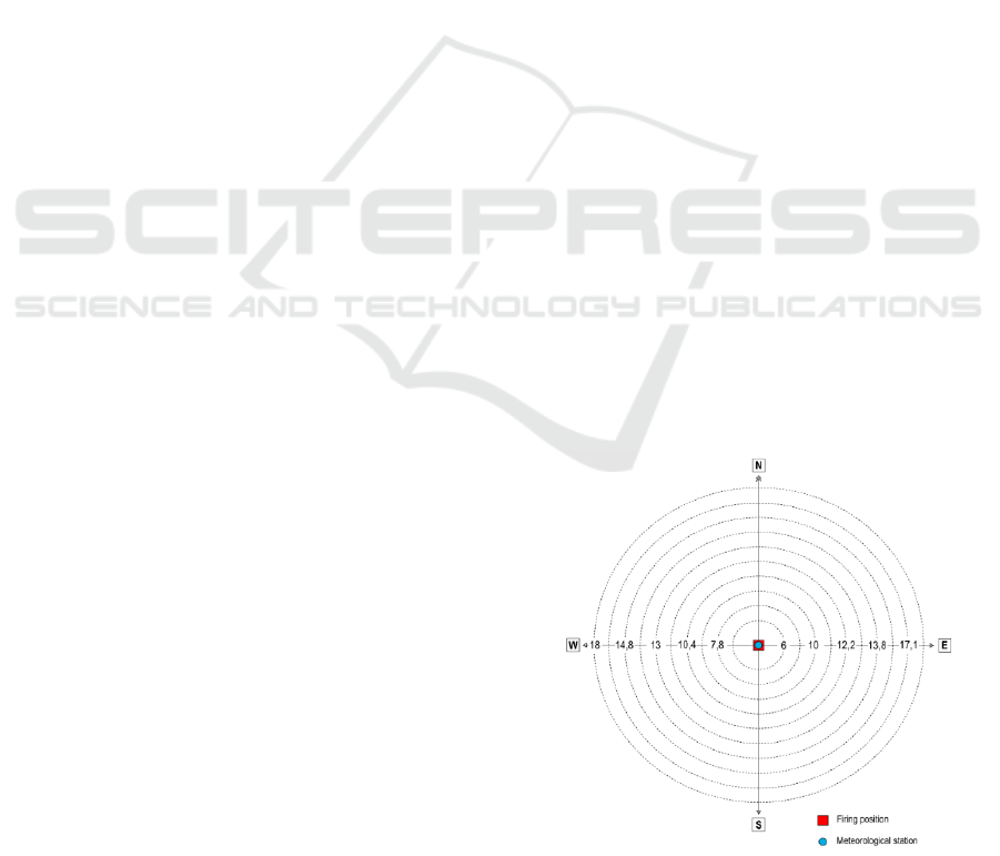
5.2 Initial Conditions for Model
Evaluation
The general preparation of firing data for artillery fire
has clearly established conditions of its execution.
These conditions relate to the spatial validity of
distance and direction corrections, requirements for
the distance of the meteorological station from the
firing position, etc.
From the point of view of the verification of the
meteorological model, these conditions had to be
modified in such a way that its applicability could be
qualitatively evaluated. From the point of view of
spatial validity, it was first of all necessary to define
for which firing directions and distances the
meteorological model will be evaluated, while the
basic principle applied by the authors in the
evaluation proposal was complexity. For this reason,
4 main directions of distance were defined, which are
identical with the cardinal directions, i.e. North,
South, East and West. In the first instance, the
author's collective assessed a more detailed
distribution of the firing directions as inexpedient.
However, the situation is different in the case of the
distance of the firing. In this case, the authors' effort
was to comprehensively divide the maximum firing
distance of the 152mm SPG M-77 so that all
individual layers of the meteorological report were
covered, and the model thus comprehensively
covered both the firing distance and equally divided
meteorological sounding altitudes. For this reason,
the firing data were calculated for the distance of 6,
7.8; 10; 10.4; 12.2; 13; 13.8; 14.8; 17.1 and 18
kilometers. One of the main aspects of the evaluation
is that, unlike the standard use of a meteorological
station, the process will be set up so that the
meteorological station is placed in exactly the same
position as the firing unit, which is the location for
which the firing data will be calculated (Fig. 5).
The evaluation process itself will then be based
exclusively on the basis of comparative analysis,
when the total range and deflection correction
calculated by the general preparation method using
the meteorological message compiled using the
meteorological model and the real meteorological
message obtained from real measurements will be
evaluated against each other. Overall, the
meteorological model will be evaluated by a
comparative analysis of the General Preparation
calculated for all indicated directions and all
distances. In total, there will be 44 results of general
preparation calculated according to the
meteorological model and 44 results of general
preparation calculated according to the real
meteorological report.
Figure 5: Positional chart for comparative calculation of
general preparation.
ICINCO 2025 - 22nd International Conference on Informatics in Control, Automation and Robotics
216

However, such an evaluation would lack a time
variable. For this reason, the same
calculation/comparison process will be performed for
four different times. Specifically, it will be real
meteorological reports obtained in each quarter of the
year.
The own evaluation of the comparative data will
also be a separate variable. Due to the circularity of
the network (Fig. 5) and the change in time data, the
author's team is considering the application of the
Rose diagram method.
6 CONCLUSION
The Emergency METEO project originates from
recent observations in the conflict in Ukraine, where
the impact of modern technologies on warfare, both
positive and negative, has become evident. In terms
of artillery, modern technologies significantly
enhance its capabilities and effectiveness. Accuracy
and long range are fundamental factors determining
the outcome of artillery fire, leading to a shift away
from mass deployment towards precision targeting.
In this evolving landscape, providing
meteorological data for fire control support becomes
crucial. However, modern conflict environments pose
challenges such as capability degradation due to
enemy activity or harsh battlefield conditions. The
Emergency METEO project aims to safeguard the
supply of meteorological data in such scenarios,
recognizing its critical importance.
The project's goal is to develop a predictive
meteorological model based on historical data. This
model would enable the generation of meteorological
messages without relying on upper air sounding or
external sources. Currently in its initial phase, the
research team is exploring various approaches to data
evaluation. The project's hypothesis is that data from
a predictive weather model will be accurate and
applicable to artillery fire. The ongoing development
phase aims to validate this hypothesis and identify
any potential issues.
One of the key elements of model development is
its evaluation. This evaluation must be complex and
precise enough, to discover all possible inaccuracies.
Because of this, it is essential to conduct the
evaluation in a way that corresponds to calculation of
firing data since the model is created mainly for
artillery. Evaluation done in a proposed way will
ensure that all minor flows would be discovered and
ensures whether it is possible to continue in
development process and research itself.
The model’s usefulness will be explicitly
evaluated by comparing corrections derived from the
predictive data to those based on real atmospheric
soundings across 44 scenarios and 4 seasonal periods,
offering a statistically grounded measure of
operational applicability.
Success in this research would represent a
significant advancement towards artillery autonomy.
NATO artillery units would gain expanded
capabilities, allowing them to fulfill their primary
tasks more effectively.
Although current results are preliminary, future
phases of the project will focus on structured
evaluation of model output using archived METB3
data and firing-table-derived indicators of ballistic
accuracy.
REFERENCES
Balon, R., Komenda, J.: Analysis of the 155 mm ERFB/BB
Projectile Trajectory. Advances in Military Technology
1(1), 91–114 (2022).
Basic aerological measurement, c 2010-2011. Czech
Hydrometeorological Institute [online]. Praha.
Hrnčiar, M., Kompan J.: Factors Shaping the Employment
of Military Force from the Perspective of the War in
Ukraine. Czech Military Revue 32(1), 069-082 (2023).
Ivan, J., Šustr, M., Sládek, D., Varech, J., Gregor, J..
Emergency Meteorological Data Preparation for
Artillery Operations. In: Proceedings of the 20th
International Conference on Informatics in Control,
Automation and Robotics (ICINCO). Řím, Itálie:
ScitePress, 2023, roč. 1, č. Volume 1, s. 250-257. ISSN
2184-2809. ISBN 978-989-758-670-5.
doi:10.5220/0012205500003543
Ivan, J., Šustr, M., Pekař, O., Potužák, L.. Prospects for the
Use of Unmanned Ground Vehicles in Artillery Survey.
In: Proceedings Of The 19th International Conference
On Informatics In Control, Automation And Robotics
(ICINCO). Lisabon, Portugalsko: SCITEPRESS, 2022,
roč. 2022, s. 467-475. ISSN 2184-2809. ISBN 978-989-
758-585-2. doi:10.5220/0011300100003271
Němec, P., Blaha, M., Pecina, M., Neubauer, J., Stodola, P.:
Optimization of the Weighted Multi-Facility Location
Problem Using MS Excel. ALGORITHMS 14(7), 191
(2021).
Nohel, J., Flasar, Z.: Maneuver Control System CZ. In:
Mazal J., Fagiolini A., Vasik P. (eds.) MODELLING
AND SIMULATION FOR AUTONOMOUS
SYSTEMS, MESAS 2019, pp. 379-388. Springer,
Heidelberg (2020).
Nohel, J., Stodola, P., Flasar, Z., Křišťálová, D.,
Zahradníček, P., Rak, L. Swarm Maneuver of Combat
UGVs on the Future Digital Battlefield. In:
MODELLING AND SIMULATION FOR
AUTONOMOUS SYSTEMS, MESAS 2022, pp. 209-
230. Springer, Heidelberg (2023).
Rolenec, O., Šilinger, K., Sedláček, M.: Algorithm
Development of the Decision-Making Process of an
Engineer Specialization Officer. In: Mazal J., Fagiolini
A., Vasik P., Turi M., Bruzzone A., Pickl S., Neumann
Evaluation Approaches for an Aggregated Meteorological Model for Artillery Operations
217

V., Stodola P. (eds.) MODELLING AND
SIMULATION FOR AUTONOMOUS SYSTEMS,
MESAS 2021, pp. 290-307. Springer, Heidelberg
(2021).
Rolenec, O., Zelený, J., Sedláček, M., Palasiewicz, T.: The
Effect of Engineer Devices for Mobility Support used
in the NATO on Command and Control. In: Kolar P.
(eds.) 8th International Conference on Military
Technologies, ICMT 2021, pp. Institute of Electrical
and Electronics Engineers Inc., Brno (2021).
Świętochowski, N.: 2019. Rules of Artillery Employment
in Combat Operations. Scientific Journal of the Military
University of Land Forces 192(2), 280-293 (2019).
Šlouf, V., Blaha, M., Müllner, V., Brizgalová, L., Pekař, O.:
An Alternative Model for Determining the Rational
Amount of Funds Allocated to Defence of the Czech
Republic in Conditions of Expected Risk. Obrana a
strategie 1/2023, 149-172 (2023).
ICINCO 2025 - 22nd International Conference on Informatics in Control, Automation and Robotics
218
