
Data Analysis of the Land Fire in California
Wenhan Zheng
a
Faculty of Science, University of Bristol, Bristol, U.K.
Keywords: Wildfire Prediction, Landfire Risk Assessment, Machine Deep Learning, Predictive Modeling, Climate Data
Analysis.
Abstract: On a typical afternoon in Los Angeles, California, on January 7, 2025, an unexpected natural disaster - the
"land fire" - broke out. This epidemic is slightly different from the past. The fire was not brought under timely
control, but continued to spread and decay, losing control. This article will attempt to focus on several types
of data collected so far. Firstly, it analyzes the linear relationship between firefighting costs and time, then
summarizes the different causes and percentages of fires in California and analyzes data on volcanic coverage
areas and total numbers before 2023. These data involve the analysis and prediction of wildfires that have
occurred in California over the past five years, including factors such as high-frequency periods, scale, and
causes, as well as attempts to use mathematical models to minimize and predict the possible consumption of
human and financial resources. Finally, some suggestions and prospects for fires were provided.
1 INTRODUCTION
To date, in the case of the previously mentioned
California mountain fires, strong winds continue to
accelerate the spread of the blazes, which have
affected more than 26,000 acres and forced the
evacuation of approximately 150,000 people
(Southern, Harding, Hurley, et al, 2025). So to better
prepare people to protect themselves in the face of
disaster, accurate fire prediction and the costs
involved have long-term implications for human
development. This research aims to optimise the
performance of the models by making more effective
predictions to provide more hilarious early warning
scenarios, allocate resources more efficiently and
reduce the likelihood of natural disasters threatening
people's lives (Hino & Field, 2023).
According to the annual statistics of natural
disasters in the United States, it is not difficult to find
that California, as a high incidence of hill fires, has
actually shown some problems in recent years, for
example, by the growing impact of greenhouse gas
emissions, the global warming has also made some
changes in the temperature of California, and with the
increase in human activities it is inevitable, because
people need to make a reasonable allocation of
a
https://orcid.org/0009-0004-7902-2954
limited resources. Rational deployment, so we should
prevent or reduce the damage caused by disasters
more efficiently (Abatzoglou & Williams, 2016).
According to research findings, it is not difficult to
see that as global temperatures rise, resulting in a
slowdown in the accumulation of water vapour in the
clouds, the most direct impact of reduced
precipitation is that the water content of the
vegetation will be reduced, which is more for the
occurrence of fires to create conditions conducive to
the occurrence of fires. Therefore, this has led to the
outbreak of mountain fires in high frequency.
Since the 1970s, the number of such disasters has
increased significantly, more than half of the increase
being due to man-made climate change. The area
covered by hill fires has also nearly doubled during
this period, and over the years, the occurrence of hill
fires has led to a very large economic expenditure,
resource loss, and even casualties.
The U.S. California Mountain fire is not the first
time. Still, in recent years, as the fire is more and more
difficult to control, the California mountain fire that
occurred in early 2025 brought unprecedented havoc
to the local people. Therefore, when more and more
people began to pay attention to this phenomenon, it
is not difficult to find that early many scholars have
noticed such a problem, hoping to have through the
292
Zheng, W.
Data Analysis of the Land Fire in California.
DOI: 10.5220/0013688200004670
Paper published under CC license (CC BY-NC-ND 4.0)
In Proceedings of the 2nd International Conference on Data Science and Engineering (ICDSE 2025), pages 292-298
ISBN: 978-989-758-765-8
Proceedings Copyright © 2025 by SCITEPRESS – Science and Technology Publications, Lda.

study of mountain fires occurring in time or spatial
patterns. Among the many findings, Westerling et al.
(2006) used historical data to analyse seasonal
patterns, turning a vague abstract perception into a
more intuitive and rational mathematical model, he
argued that the first half of the year, in fact, that is,
spring and summer, California's mountainous and
forested areas are usually high-frequency occurrence
of mountain fires, summing up the occurrence of the
California Mountain Fire The reason for the
occurrence of the California mountain fires may not
be because of the season, but there must be some kind
of strong correlation between the two.
In subsequent analyses, some scholars have
suggested that a mixture of more frequent daily
human activities and insufficient management and
protection of forest resources have indirectly
contributed to the problem.
This paper focuses on the collected data on
wildfires that have occurred in California over the
past five years, including analysis of factors such as
high-frequency periods, scale, and causes of wildfires,
as well as attempts to use mathematical models to
minimize and predict the potential consumption of
human and financial resources.
2 RELATED WORKS
In recent years, with the continuous development of
data science and the unremitting efforts of scholars,
people have tried to believe that mathematical models
can help people solve many life problems. Predictive
modelling is the best solution to meet various natural
geological disasters and other emergencies. In the
paper of Abatzoglou & Kolden (2013), they took and
analyzed various collected data and constructed a
more perfect statistical model for the prediction of
mountain fires, because in the whole process, they
took into account as much as possible all kinds of
variables that may affect the results, topographic
factors, wind factors, climate conditions are all taken
into account, which makes the prediction based on
real data as a support to the model. This makes the
prediction models supported by real data more
accurate and more convincing.
Later on, with the continuous updating and
iteration of observation technology, remote sensing
technology can be more powerful through satellites
outside the sky, better use of spatial distribution, real-
time follow-up of various data, as well as UHF
transmission of real-time monitoring data through
satellites have become the best aid to assist in the
judgement process, but some human factors will
greatly affect the analysis process and results, which
is an insurmountable problem for the time being. This
is an insurmountable problem. But the emergence of
remote sensing technology, to a large extent, in
addition to human influence, completes the task of
data collection. And some scholars have borrowed
such remote sensing data combined with data models
to analyze the high-risk areas of the California
wildfires, and ultimately succeeded in predicting the
outbreak of several areas.
The deep learning model of the machine has made
the accuracy of the model in the prediction process
much better than before. Many researchers use
algorithms such as SVM (SVM: Support Vector
Machine), RF (Random Forest), etc. to perform
simulations and give the final results of the algorithm.
This process is also due to the rise of machine self-
learning technology, which helps research teams to
continuously improve and optimize, which is very
helpful to analyze and find out the potential factors
affecting the prediction results, which are different
from the normal logic of human thinking, and may be
overlooked.
The use of mathematical models is not really out
of reach for humans, on the contrary as early as in the
paper by Green, Kaiser & Shenton (2020) the
evolution of the regions around the mountain fires has
been predicted through the analysis of various
graphical data and modeled by deep convolutional
neural networks with very successful results in the
Sierra Nevada of the Western Sierras, so it is all the
more important to try to find commonalities of
successful cases in this process, which is very
meaningful for the development of new Machine
Deep Learning models. This process of finding
commonalities in successful cases is very relevant for
the development of new Machine Deep Learning
models.
Overall, as of the end of 2019, the researchers
have counted around 300 publications on the most
commonly used machine learning methods across a
wide range of problem domains, including Max Ent,
Artificial Neural Networks, Decision Trees, Genetic
Algorithms, and so on. This means that there are
differences in the ability of each model to learn and
produce results under different conditions and
environments, which leaves the human race to think
about progress and hopefully continue to develop or
derive a completely new algorithm (Jain et al., 2020).
More advanced deep learning methods such as
CNNs (Convolutional Neural Networks) and LSTMs
(Long Short-Term Memory Networks) are being
developed to optimize both temporal and spatial data,
Hosseini et al. (2020). In this process, through the real
Data Analysis of the Land Fire in California
293

occurrence of mountain fires after data collection, and
the prediction of comparison, it is not difficult to find
that the LSTM model for the California mountain fire
time series prediction, in the long time dependence of
the performance is pretty good. In recent years, with
the continuous development of data science and the
unremitting efforts of scholars, people have tried to
believe that mathematical models can help people
solve many life problems. Predictive modelling is the
best solution to meet various natural geological
disasters and other emergencies. In the paper of
Abatzoglou & Kolden (2013), they took and analyzed
various collected data and constructed a more perfect
statistical model for the prediction of mountain fires,
because in the whole process, they took into account
as much as possible all kinds of variables that may
affect the results, topographic factors, wind factors,
climate conditions are all taken into account, which
makes the prediction based on real data as a support
to the model. This makes the prediction models
supported by real data more accurate and more
convincing.
Later on, with the continuous updating and
iteration of observation technology, remote sensing
technology can be more powerful through satellites
outside the sky, better use of spatial distribution, real-
time follow-up of various data, as well as UHF
transmission of real-time monitoring data through
satellites have become the best aid to assist in the
judgement process, but some human factors will
greatly affect the analysis process and results, which
is an insurmountable problem for the time being. This
is an insurmountable problem. But the emergence of
remote sensing technology, to a large extent, in
addition to human influence, completes the task of
data collection. And some scholars have borrowed
such remote sensing data combined with data models
to analyze the high-risk areas of the California
wildfires, and ultimately succeeded in predicting the
outbreak of several areas.
The deep learning model of the machine has made
the accuracy of the model in the prediction process
much better than before. Many researchers use
algorithms such as SVM (SVM: Support Vector
Machine), RF (Random Forest), etc. to perform
simulations and give the final results of the algorithm.
This process is also due to the rise of machine self-
learning technology, which helps research teams to
continuously improve and optimize, which is very
helpful to analyze and find out the potential factors
affecting the prediction results, which are different
from the normal logic of human thinking, and may be
overlooked.
The use of mathematical models is not really out
of reach for humans, on the contrary as early as in the
paper by Green, Kaiser & Shenton (2020) the
evolution of the regions around the mountain fires has
been predicted through the analysis of various
graphical data and modeled by deep convolutional
neural networks with very successful results in the
Sierra Nevada of the Western Sierras, so it is all the
more important to try to find commonalities of
successful cases in this process, which is very
meaningful for the development of new Machine
Deep Learning models. This process of finding
commonalities in successful cases is very relevant for
the development of new Machine Deep Learning
models.
Overall, as of the end of 2019, the researchers
have counted around 300 publications on the most
commonly used machine learning methods across a
wide range of problem domains, including Max Ent,
Artificial Neural Networks, Decision Trees, Genetic
Algorithms, and so on. This means that there are
differences in the ability of each model to learn and
produce results under different conditions and
environments, which leaves the human race to think
about progress and hopefully continue to develop or
derive a completely new algorithm (Jain et al., 2020).
More advanced deep learning methods such as
CNNs (Convolutional Neural Networks) and LSTMs
(Long Short-Term Memory Networks) are being
developed to optimize both temporal and spatial data,
Hosseini et al. (2020). In this process, through the real
occurrence of mountain fires after data collection, and
the prediction of comparison, it is not difficult to find
that the LSTM model for the California mountain fire
time series prediction, in the long time dependence of
the performance is pretty good.
3 RESEARCH METHODOLOGY
3.1 Data Overview and Collection
The dataset used in this analysis contains information
such as the time of the hill fire, the exact location, the
cause of the fire, the duration, the estimated spread
area, the number of casualties, the expected damage
to property, casualty statistics, etc. Before analyzing
the acquired data, the analysis focused on the fires
that occurred in Los Angeles, California, USA,
because of the random nature of the fires.
1. The time of the occurrence
2. Duration of the disaster
3. The scene of the incident
4. Types of incentives
ICDSE 2025 - The International Conference on Data Science and Engineering
294
5. Casualty statistics
3.2 Statistic Analysis
In comparison with the 5-Year Average, the 2025
statistics show a much higher number of fires (164 vs.
76) and acres burned (40,695 vs. 30) compared to the
5-year average. This further confirms the severity of
the current fire season in comparison to previous
years.
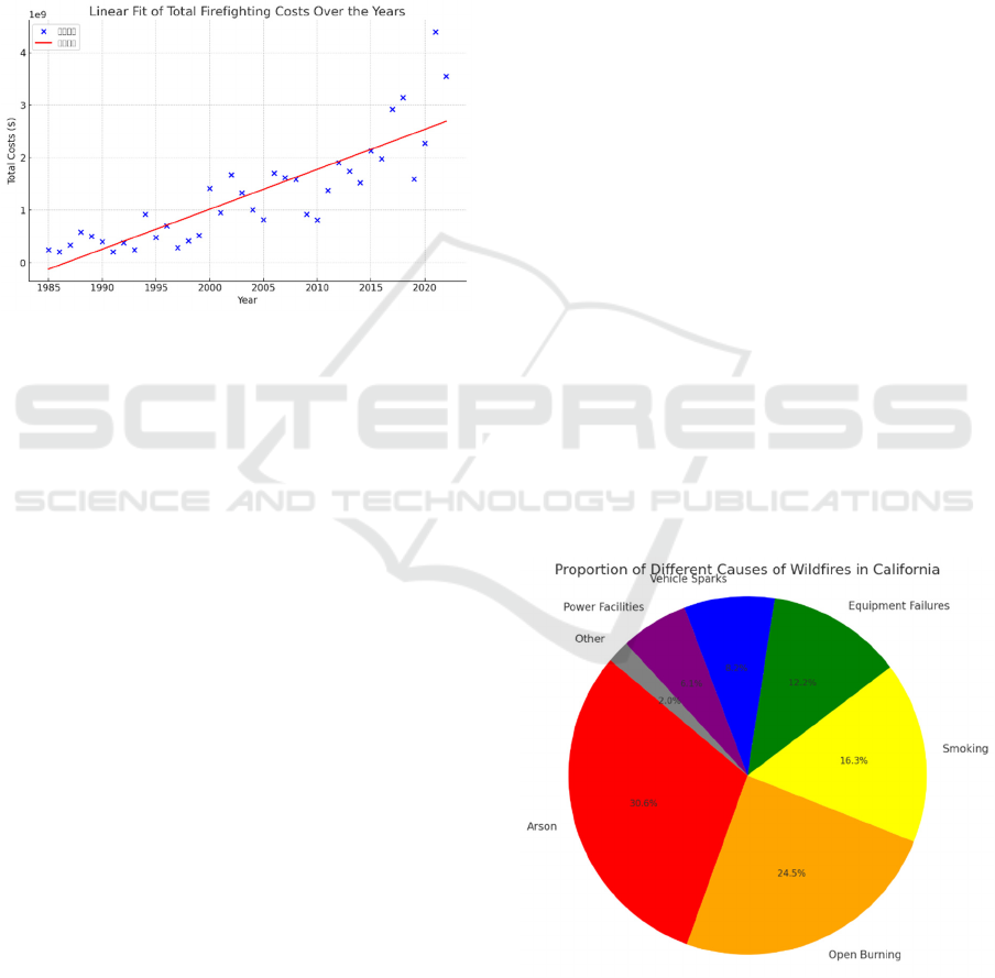
Figure 1: Linear fit of costs (Picture credit: Original)
4 RESULTS OF THE
EXPERIMENT
4.1 Analysis of the data
With historical statistics to back up the analysis, it is
easy to see that the level of human activity is different
from a century ago, excessive behavioural activity
has already had a non-negligible impact on the results
of the model, and the anthropogenic variables, as
reported in (Mann et al.,2016), are shown to at least
make the significance of climatic factors misjudged
i.e. climatic conditions are misjudged to be the trigger
of the events such as those that lead to the mountain
fires probability would increase by 24% close to a
quarter. And that would lead the study in a direction
skewed away from the facts. So this emphasizes the
model and tests the ability of the model to combine
multiple factor variables and also puts a higher
demand on the accuracy of the correlation of the
variables.
Figure 1 shows a positive correlation, meaning
that as the years progress, the total firefighting costs
also exhibit an upward trend. The trend is represented
by the red linear fit line. Contrasting the data with
years, the number of wildfires in 2023 is below the
five-year and 10-year averages, and down from
previous years. The Correlation (R-value) shown in
the graph represents a linear fit, and visually, it shows
a linear relationship, indicating that the data points
generally follow an increasing trend. There are also
outliers that could not be ignored. During the
preprocessing part of the data before fitting the linear
relationship, it was calculated that the outliers occur
more frequently in the early 1980s and 2000s. They
are completely off the predicted straight line and
outside the IQR (Interquartile Range). The straight
line fitted by the data calculation, analysis, and most
of the cases are between the real data high and low
sides, the deviation is not big, which shows that the
linear model is still good for the prediction of the
expenditure model fitting effect.
4.2 Prediction and Conclusion
In the U.S. statistics show that most of the triggers of
life, in fact, are man-made, and common causes of
fires include high temperatures, low humidity in
forested vegetation, and thunderstorms in which sky
lightning strikes flammable materials or man-made,
but surprisingly the area burned and covered by
mountain fires caused by man-made causes is more
than twice the area burned by natural causes (Balch et
al.,2017).
The predictive results of the entire model appear
to be quite good and should continue to be successful
in predicting fire protection expenditures in the
coming years, but if more complex models or
variables can be considered, the predictions and
models will be more reliable.
Figure 2: Proportion of the causes (Picture credit:
Original)
Figure 2 gives a very clear picture of the different
types of causes of the California fires, and the
Data Analysis of the Land Fire in California
295
percentages. Of these, 71.9% are attributed to Arson,
Smoking, and Open Burning, which together make up
the most significant contributors, with the remainder
being mostly caused by aging machinery and
equipment, or damaged energy equipment.
The above statement does not mean that there is
no link between climate change and the frequency of
hill fires. On the contrary, in Turco et al (2023), it is
argued that for nearly a quarter of a century, between
1996 and 2020, the number of hill fires in the
California region of the United States was five times
higher than the number of fires that had occurred
between 1971 and 1995, and that these changes were
most directly attributable to the climate change that
was evident in the investigations and modelling
analyses.
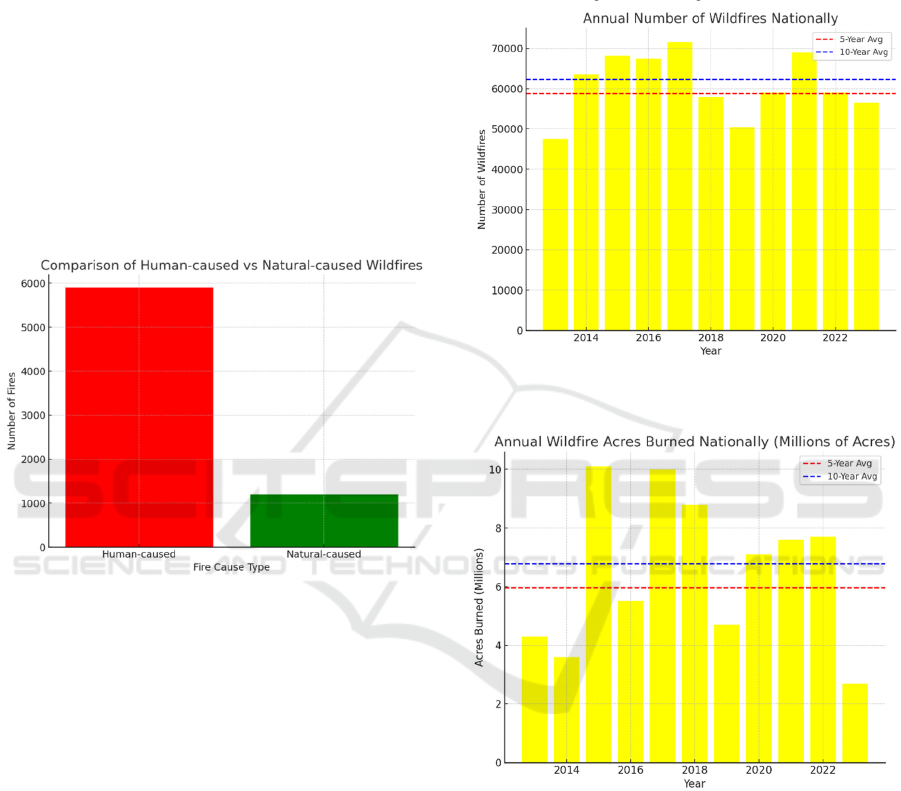
Figure 3: Comparison of two kinds of wildwires
(Picture credit: Original)
Figure 3 shows the number of California fires
caused by both human-caused and natural factors
over the years, with the former portion being
significantly higher than the latter portion. Human-
caused factors (especially Arson, Open Burning, and
Smoking) are the primary drivers Human-caused
factors (especially Arson, Open Burning, and
Smoking) are the primary drivers behind wildfires in
California, accounting for over 75% of total fires.
In short, based on the data provided by CAL FIRE
each year, it is easy to see that fire protection
expenditures have been on the rise, and accordingly,
some policies or adjustments may be needed to help
better manage the situation, such as severe penalties
for arsonists, harsher fines, or more maintenance and
improvement of forests. For those outliers, although
they may not be used by the model, if they occur
consecutively, they indicate that the model is
inappropriate or that something very bad is going to
happen, which can serve as a good warning.
However, because the mountain fires occurring in
early 2025 are different from previous cases, they will
be ignored as outliers during data processing so as not
to affect the results of the analyses, and the paper will
concentrate on analyzing the complete data before
2023. As the figure 4 and figure 5 below shows.
Figure 4: Total number of the fires (Picture credit:
Original)
Figure 5: Area covered by hill fires
(Millions of Acres) (Picture credit: Original)
The horizontal dashed lines represent averages
over the past five and ten years, providing a clear
visual reference for 2023 comparison with historical
data.
5 SUGGESTIONS
5.1 Enhanced Fire Prevention and
Awareness Campaigns
Enhanced Fire Prevention and Awareness Campaigns
ICDSE 2025 - The International Conference on Data Science and Engineering
296

Strengthening the publicity and education on fire
prevention awareness from childhood, and reasonable
community-focused education are very targeted
preventive activities, which can effectively reduce the
number of hill fires caused by the human factor,
because the human factor is very often unconsciously
caused by human beings seemingly small behavior.
This is an approach that requires long-term persistent
supervision, but the effect will not be immediate.
5.2 Stronger Regulations and
Enforcement
Human-caused fires must be dealt with seriously, and
regulations must be strengthened, while utilities must
reinforce infrastructure such as fences, power grids
and walls to minimize the possibility of human
influence. Secondly, clearer regulations and penalties
should be added for the use of pyrotechnics and
automotive equipment.
5.3 Improve Firefighting and
Emergency Response
While maintaining current firefighting expenditures,
the use of various drone technologies, similar to the
class of drones, replaces humans in a variety of high-
risk rescue activities, data-monitoring activities,
emergency response, and other tasks. All of these
need more funding as support. Because robots can
detect fires earlier and more timely, at an earlier time
to contain the spread of fire.
Secondly, for accident prone areas, the use of
cameras should be more widespread and the
implementation of remote sensing technology is
imperative. Similarly, in the face of a lack of
materials, the optimal allocation of resources is also
necessary, as long as this can be avoided, the dilemma
of emergency rescue supplies. Emergency evacuation
drills, while enhancing people's self-protection, can
also make the face of disaster, human beings are
harmed can be reduced to a minimum.
6 CONCLUSIONS
Based on the statistical results, graphs, etc., it is clear
that the frequency of hill fires in California has been
escalating in recent decades. In particular, the area
covered by each fire has been expanding, and the
summer burned area in northern and central
California has increased about five-fold from 1996-
2021 compared to 1971-1995. Secondly, for a
seasonal problem such as hill fires, the extreme
seasonal anomalies that are generated illustrate how
the severity of hill fires has repeatedly challenged the
limits of human control over nature. These anomalies
need to be explained, and the dramatic changes in
climatic conditions leading to higher temperatures
and drying out of the ground as a direct result of the
fires are lengthening the duration of the high fire
season.
And while trying to find ways to control the fire,
humans should also face their problems, according to
the results of the data mediation shows that about
85% of the mountain fires are for ignition caused in,
human causes including accidents as well as
negligence but are not an excuse for humans to ignore
the problem.
For the existing mountain fire prediction models,
continuous optimisation and technological updates
are also important. First of all, AI algorithms should
be integrated into the process of predictive algorithms
to improve the ability to sense the state of affairs, so
that he can be the first time through the network to
obtain a variety of data at the same time, using their
arithmetic power to analyse satellite imagery,
mapping, providing rescue options route, and so on.
Similarly, it is important to continue to develop
hybrid modelling, as the models I have used in this
thesis are the most basic data analysis models, which
can vary greatly in accuracy when faced with
multivariate, dynamic data problems. In conclusion,
improving the entire algorithmic model is also a
multifaceted endeavour that needs to be taken in
tandem to better protect humans from themselves.
REFERENCES
Abatzoglou, J. T., & Kolden, C. A. 2013. Climate change
in western US deserts: Potential for increased wildfire.
International Journal of Wildland Fire, 22(5), 635-645.
Abatzoglou, J. T., & Williams, A. P. 2016. Impact of
anthropogenic climate change on wildfire across
western US forests. Proceedings of the National
Academy of Sciences, 113(42), 11770-11775.
Balch, J. K., Bradley, B. A., Abatzoglou, J. T., Nagy, R. C.,
Fusco, E. J., & Mahood, A. L. 2017. Human-started
wildfires expand the fire niche across the United States.
Proceedings of the National Academy of Sciences,
114(11), 2946–2951.
Faramarzi, H., Hosseini, S. M., Pourghasemi, H. R., &
Farnaghi, M. 2021. Forest fire spatial modelling using
ordered weighted averaging multi-criteria
evaluation. Journal of Forest Science, 67(2), 87-100.
Green, M. E., Kaiser, K., & Shenton, N. 2020. Modeling
wildfire perimeter evolution using deep neural
networks. arXiv. https://arxiv.org/abs/2009.03977
Data Analysis of the Land Fire in California
297

Hino, M., & Field, C. B. 2023. Fire frequency and
vulnerability in California. PLOS Climate, 2(2),
e0000087.
Jain, P., Coogan, S. C. P., Subramanian, S. G., Crowley, M.,
Taylor, S., & Flannigan, M. D. 2020. A review of
machine learning applications in wildfire science and
management. Environmental Reviews, 28(4), 478–505.
Mann, M. L., Batllori, E., Moritz, M. A., Waller, E. K.,
Berck, P., Flint, A. L., Flint, L. E., & Dolfi, E. 2016.
Incorporating anthropogenic influences into fire
probability models: Effects of human activity and
climate change on fire activity in California. PLOS
ONE, 11(4), e0153589.
Southern, K., Harding, D., Hurley, B., & Blanco, A. 2025.
California fire forces evacuation of Pacific Palisades in
Los Angeles. The Times.
Turco, M., Abatzoglou, J. T., Herrera, S., Zhuang, Y., Jerez,
S., Lucas, D. D., AghaKouchak, A., & Cvijanović, I.
2023. Anthropogenic climate change impacts
exacerbate summer forest fires in California.
Proceedings of the National Academy of Sciences,
120(25), e2213815120.
ICDSE 2025 - The International Conference on Data Science and Engineering
298
