
ORB-Based Map Fusion with Position Transformation
for Enhanced Pairwise Connection
Lucas Alexandre Zick
1,2
, Dieisson Martinelli
1,2
, Andre Schneider de Oliveira
1
and Vivian Cremer Kalempa
2
1
Graduate Program in Electrical and Computer Engineering, Universidade Tecnol
´
ogica Federal do Paran
´
a (UTFPR),
Curitiba, Brazil
2
Department of Information Systems, Universidade do Estado de Santa Catarina (UDESC), S
˜
ao Bento do Sul, Brazil
Keywords:
Map Fusion, Robot Localization, ORB Algorithm, Pairwise Map Alignment.
Abstract:
This paper discusses developing and evaluating a map fusion algorithm based on ORB (Oriented FAST and Ro-
tated BRIEF) feature matching, designed to improve the integration of robotic occupancy grids. The algorithm
effectively merges maps generated by multiple robots, accommodating map size and orientation variations. A
key aspect of its functionality is the ability to accurately position robots within the fused map, even when
the overlap between maps is minimal. Comprehensive testing demonstrated the algorithm’s effectiveness in
identifying correlations between different map pairs and aligning them accurately, as well as its capability to
assess the success of the merging process, distinguishing between successful merges and those with inaccu-
racies. The findings indicate that this approach significantly enhances the capabilities of multi-robot systems,
improving navigation and operational efficiency in complex environments.
1 INTRODUCTION
The presence of multi-robot systems in robotics has
significantly expanded the range of possible solutions,
primarily improving task execution speed (Gautam
and Mohan, 2012). Due to the growing ease of imple-
menting these technologies, multi-robot systems have
become increasingly common in academic research
and industrial settings (Arai et al., 2002; Va
ˇ
s
ˇ
c
´
ak and
Herich, 2023). This collaborative approach allows
tasks to be performed more quickly and efficiently
and facilitates the resolution of complex problems
that would be challenging for robots operating inde-
pendently.
In addition to efficiency, using multiple robots
also provides additional advantages, such as the abil-
ity to perform simultaneous tasks at different points
within an environment (Gautam and Mohan, 2012).
This is particularly useful in scenarios such as ex-
ploring unknown environments, monitoring vast areas
(such as space exploration), and conducting search
and rescue operations (Chakraa et al., 2023). With ad-
vancements in communication and sensing technolo-
gies, robots can share information in real time, en-
abling better coordination and a more accurate under-
standing of the environment in which they operate.
However, this growing reliance on multi-robot
systems brings specific challenges to the forefront,
particularly in map fusion and the integration of sen-
sory information (Stathoulopoulos et al., 2023). The
ability of different robots to merge their mapping data,
especially in situations where the maps may be dis-
connected or incomplete, is crucial for ensuring func-
tional autonomous navigation and operational effec-
tiveness (Mukhopadhyay et al., 2023). Therefore,
research into robust and scalable map fusion tech-
niques becomes essential for the success of multi-
robot systems in real-world applications (Ahmed Jalil
and Kasim Ibraheem, 2023).
Among the most promising solutions to address
these challenges is the ORB (Oriented FAST and
Rotated BRIEF) algorithm, which is widely used in
robotics and computer vision applications (Ahmed
et al., 2024). ORB is characterized by its fast and effi-
cient detection of keypoints and its robustness in rec-
ognizing visual patterns, even in situations with vari-
ations in orientation or scale (Karami et al., 2017).
Its application in map fusion allows for the identi-
fication of correspondences between different maps
generated by robots of varying models in dynamic
environments, facilitating the combination of visual
data and the construction of a unified map. Addition-
Zick, L. A., Martinelli, D., de Oliveira, A. S. and Kalempa, V. C.
ORB-Based Map Fusion with Position Transformation for Enhanced Pairwise Connection.
DOI: 10.5220/0013670500003982
Paper published under CC license (CC BY-NC-ND 4.0)
In Proceedings of the 22nd International Conference on Informatics in Control, Automation and Robotics (ICINCO 2025) - Volume 2, pages 185-193
ISBN: 978-989-758-770-2; ISSN: 2184-2809
Proceedings Copyright © 2025 by SCITEPRESS – Science and Technology Publications, Lda.
185

ally, ORB provides an efficient solution for handling
large-scale maps, demonstrating good scalability re-
garding processing time and memory usage (Sabry
et al., 2024).
In this context, this work aims to develop an ap-
proach for map fusion based on ORB, focusing not
only on the combination of the maps themselves but
also on the precise transformation of the positions of
multiple robots within the final map. By effectively
integrating the mapping data from two robots, it be-
comes possible to construct a unified map of the en-
vironment and accurately transform the robots’ po-
sitions within the resulting map, ensuring more effi-
cient, safe, and coordinated navigation. Additionally,
the ORB algorithm utilized in this approach can as-
sess the likelihood of overlap between the provided
maps. This capability allows the system to identify
scenarios where the maps are disconnected or have
minimal overlap, avoiding unnecessary processing for
non-connected maps and optimizing data fusion only
when relevant. Thus, the proposed solution is robust
enough to handle maps of varying sizes and scenar-
ios where the robots lack complete environmental in-
formation, providing a more efficient and adaptable
solution for multi-robot systems.
The contributions of this work include the devel-
opment of a scalable map fusion technique based on
the ORB algorithm, designed to handle partial overlap
or disconnection between maps, and implementing a
mechanism to correctly transform and align the posi-
tions of robots within the final map. The experimen-
tal validation of the approach was conducted exclu-
sively in simulated scenarios, using randomly gener-
ated maps, which allowed for controlled testing of the
technique’s robustness and effectiveness. Although
the results demonstrate the potential of ORB-based
map fusion in virtual multi-robot systems, continu-
ous real-time application in physical robots has not
yet been explored. This represents the next step to
expand the research, validating the approach in real-
world and challenging environments, where the vari-
ations of the physical world can further demonstrate
the technique’s feasibility in practical situations.
The main contribution of this work is an integrated
framework for map fusion that addresses the practi-
cal challenge of aligning maps with partial or discon-
nected overlaps while ensuring the correct transfor-
mation of robot positions into the unified reference
frame. While foundational techniques like ORB are
well-established, our work focuses on their applica-
tion within a system that can reliably determine when
to merge maps and how to accurately place each robot
within the resulting shared environment. This ap-
proach is validated through a quantitative error met-
ric that enhances the system’s reliability by discarding
low-quality fusions. The experimental validation was
conducted exclusively in simulated scenarios, which
allowed for controlled testing of the technique’s ro-
bustness. Although these results are promising, real-
time application on physical robots has not yet been
explored and represents the next step to validate the
approach in challenging real-world environments.
The structure of the paper is as follows: Section
Proposed Strategy provides a detailed presentation of
the algorithm’s development. Section Experiments
and Validation introduces the experiments and valida-
tions conducted, along with the obtained results. Fi-
nally, Section Conclusion offers concluding remarks
and discusses potential future work.
2 RELATED WORK
In the field of map fusion for multi-robot systems,
various approaches have been proposed to enhance
the integration of mapping data from multiple robots.
One notable work is by Dieisson Martinelli, who de-
veloped a method that requires standard references
within the mapped environments (Martinelli et al.,
2023). While Martinelli’s approach effectively facili-
tates the merging of maps when such references are
available, it presents limitations in scenarios where
robots operate in disconnected or unreferenced envi-
ronments. In contrast, the proposed ORB-based al-
gorithm does not necessitate standard references be-
tween the maps, allowing for greater flexibility and
applicability across diverse environments.
Moreover, one of the key advantages of our ap-
proach is its ability to identify non-overlapping maps
rather than forcing a potentially inaccurate overlap.
This capability enhances the algorithm’s robustness
in dealing with disconnected environments and pre-
vents the introduction of erroneous data into the final
fused map.
However, it is important to acknowledge that
while our method demonstrates advantages regard-
ing reference independence and accurate identifica-
tion of map relationships, it has yet to be validated
in real-world scenarios. The reliance on simulated
environments raises questions about the algorithm’s
robustness and effectiveness in dynamic and unpre-
dictable settings typically encountered in practical ap-
plications.
ICINCO 2025 - 22nd International Conference on Informatics in Control, Automation and Robotics
186
3 ORB-BASED MAP FUSION
This section discusses the proposed methodology to
address the challenges of map fusion and robot posi-
tion transformation using the ORB algorithm. The
proposed approach focuses on accurately detecting
overlapping areas between maps and efficiently merg-
ing them while ensuring the correct transformation of
the robots’ positions in the final unified map. The fol-
lowing subsections outline the key components of our
method, including map overlap detection, the fusion
process, and position transformation.
3.1 Overview of the ORB Algorithm
The ORB (Oriented FAST and Rotated BRIEF) al-
gorithm is a robust feature detection and description
method widely used in computer vision. Developed
to overcome the limitations of traditional feature de-
tectors like SIFT and SURF, ORB is both computa-
tionally efficient and invariant to rotations and scales,
making it ideal for real-time applications (Karami
et al., 2017; Yan et al., 2023).
The first step in the ORB algorithm is key point
detection using the FAST (Features from Accelerated
Segment Test) method. FAST identifies corners in an
image, which are potential key points. Each detected
key point is then oriented based on the intensity cen-
troid, ensuring that the features remain consistent un-
der rotation (Karami et al., 2017; Yan et al., 2023).
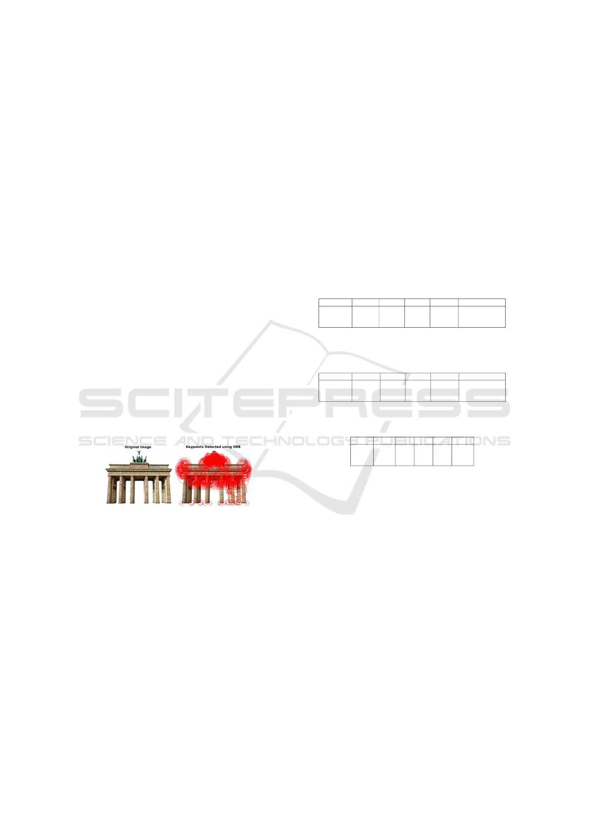
Figure 1: Keypoints detected by the ORB algorithm over-
layed on the original image.
Once the keypoints are detected, the ORB algo-
rithm describes these points using the BRIEF descrip-
tor, which compares the intensity of pixels around the
keypoint. This results in a binary string representing
the key point’s feature, enabling rapid matching be-
tween different images (Wu, 2023).
The benefits of using ORB include its invariance
to rotation and scale, allowing features to be recog-
nized regardless of the image’s orientation or size.
Additionally, the algorithm offers high computational
efficiency compared to other methods, enabling real-
time operations. As illustrated in Table 1, ORB op-
erates significantly faster than SIFT and SURF, with
execution times of just 0.02 seconds compared to 0.25
seconds for SIFT and 0.08 seconds for SURF, while
achieving a match rate that is close to its counterparts
(Karami et al., 2017).
Furthermore, the results in Table 2 highlight
ORB’s robustness against noise, achieving a match
rate of 54.48%, slightly higher than SIFT’s 53.8%
which demonstrates ORB’s ability to maintain perfor-
mance even in challenging conditions. Additionally,
ORB shows its effectiveness in varied scenarios, as
indicated in Table 3, where it maintains competitive
matching rates across different rotation angles. This
combination of speed and accuracy makes ORB an
ideal choice for applications requiring reliable perfor-
mance under diverse and complex conditions (Karami
et al., 2017; Cong, 2024).
Table 1: Results of comparing the image with its scaled
version. Reproduced from Karami et al. (2017). (Karami
et al., 2017)
Algorithm Time(s) Kpnts1 Kpnts2 Matches Match Rate (%)
SIFT 0.25 248 1210 232 31.8
SURF 0.08 162 581 136 36.6
ORB 0.02 261 471 181 49.5
Table 2: Results of the image matching by adding 30%
of salt and pepper noise. Reproduced from Karami et al.
(2017). (Karami et al., 2017)
Algorithm Time (s) Kpnts1 Kpnts2 Matches Match Rate (%)
SIFT 0.115 248 242 132 53.8
SURF 0.059 162 385 108 39.48
ORB 0.027 261 308 155 54.48
Table 3: Matching rate versus the rotation angle. Repro-
duced from Karami et al. (2017). (Karami et al., 2017)
Angle 0 45 90 135 180
SIFT 100% 65% 93% 67% 92%
SURF 99% 51% 99% 52% 96%
ORB 100% 46% 97% 46% 100%
In multirobot mapping scenarios, ORB facili-
tates effective map fusion by providing robust feature
matching between disconnected maps. This capabil-
ity of detecting and describing features in real time
can enhance the efficiency of collaborative robotic
systems (Sing
´
eis, 2024).
In conclusion, the choice of the ORB algorithm
is fundamental for the proposed map fusion strat-
egy, as it ensures accurate detection and description
of keypoints while maintaining computational effi-
ciency. Furthermore, ORB excels in handling the dy-
namic nature of map sizes, essential in robotics appli-
cations where varied and complex environments may
be explored (Cong, 2024).
3.2 Map Generation and Patch
Extraction
In this work, an algorithm was developed for the dy-
namic and random generation of structured maps, en-
suring that each created map is unique. The function
ORB-Based Map Fusion with Position Transformation for Enhanced Pairwise Connection
187
generate structured map(size) generates a map
represented as a 2D matrix of dimension size × size,
where the value zero (0) represents free spaces and the
value one (1) represents obstacles. The default size of
the map is 550 × 550 pixels.
The map creation involves adding various geomet-
ric shapes, such as rectangles, circles, and ellipses,
using auxiliary functions that allow the inclusion of
varied elements in the environment. Below, we de-
scribe some of these functions and the associated cal-
culations:
• add rectangle(x, y, width, height,
angle): This function inserts rectangles into the
map, potentially applying a rotation according
to the specified angle. The coordinates of the
rectangle’s vertices are calculated from (x, y),
where x and y represent the position of the
top-left corner. The dimensions of the rectangle
are given by the parameters width and height.
The calculation of the rotated coordinates is done
using the rotation matrix:
R =
cos(θ) −sin(θ)
sin(θ) cos(θ)
where θ is the rotation angle.
• add circle(x, y, radius): For the insertion
of a circle, the function calculates the points that
satisfy the equation, where (x, y) are the coordi-
nates of the center of the circle and (X, Y ) are the
coordinates of any point within the circle:
(X − x)
2
+ (Y − y)
2
≤ radius
2
• add ellipse(x, y, r1, r2, angle): With
this function, ellipses can be added to the map.
The equation of the ellipse is given by:
(X − x)
2
r1
2
+
(Y − y)
2
r2
2
≤ 1
where (x, y) represents the center of the ellipse
and r1 and r2 are the radii of the ellipse along the
X and Y axes, respectively.
Randomness is a crucial aspect of the algorithm.
The function add large areas() creates a non-fixed
number of large areas, where the size is randomly de-
termined within a variable range.
The function add corridors() generates a non-
fixed number of corridors, where the width of the cor-
ridor is also a random value, and the length is equal
to the size of the map. The starting coordinates for
these corridors are selected randomly, ensuring a var-
ied distribution of obstacles.
The function extract patch(map,
patch size) is responsible for extracting
patches from the generated map. The patch
is randomly rotated, and the coordinates for
extraction are calculated using the function
get random patch coordinates(map size,
patch size), which ensures that the starting coor-
dinates (x, y) of the patch are within the map limits.
The coordinates are obtained through:
x
start
= random.randint(0, map size − patch size[0])
y
start
= random.randint(0, map size − patch size[1])
This ensures that the extracted patch does not ex-
ceed the dimensions of the map. An example of gen-
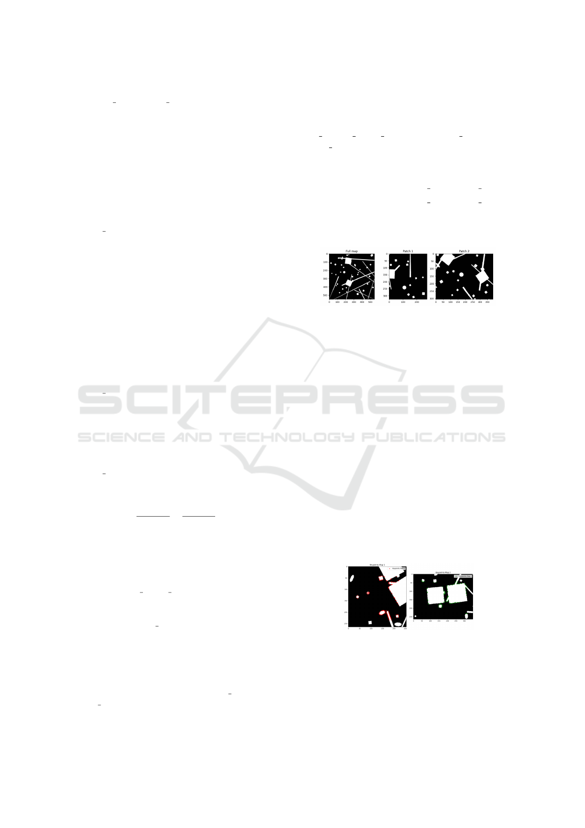
erated map and patches is presented in Figure 2
Figure 2: Example of generated map and patches.
The algorithm for generating structured maps and
extracting patches provides a diverse and dynamic
testing environment, allowing for practical and com-
prehensive experiments in map fusion and pattern
recognition.
3.3 Map Fusion Process
The map fusion process is crucial for integrating in-
formation from different sources, especially in sce-
narios where maps may have varying sizes and reso-
lutions (Martinelli et al., 2023). Fusion begins with
detecting and describing features in the maps using
algorithms such as ORB (Oriented FAST and Rotated
BRIEF). Once key points and their descriptors are ex-
tracted, the next step is to find matches between the
descriptors of the two maps. Using BFMatcher, the
correspondences that indicate which features of one
map correspond to features of the other are identified.
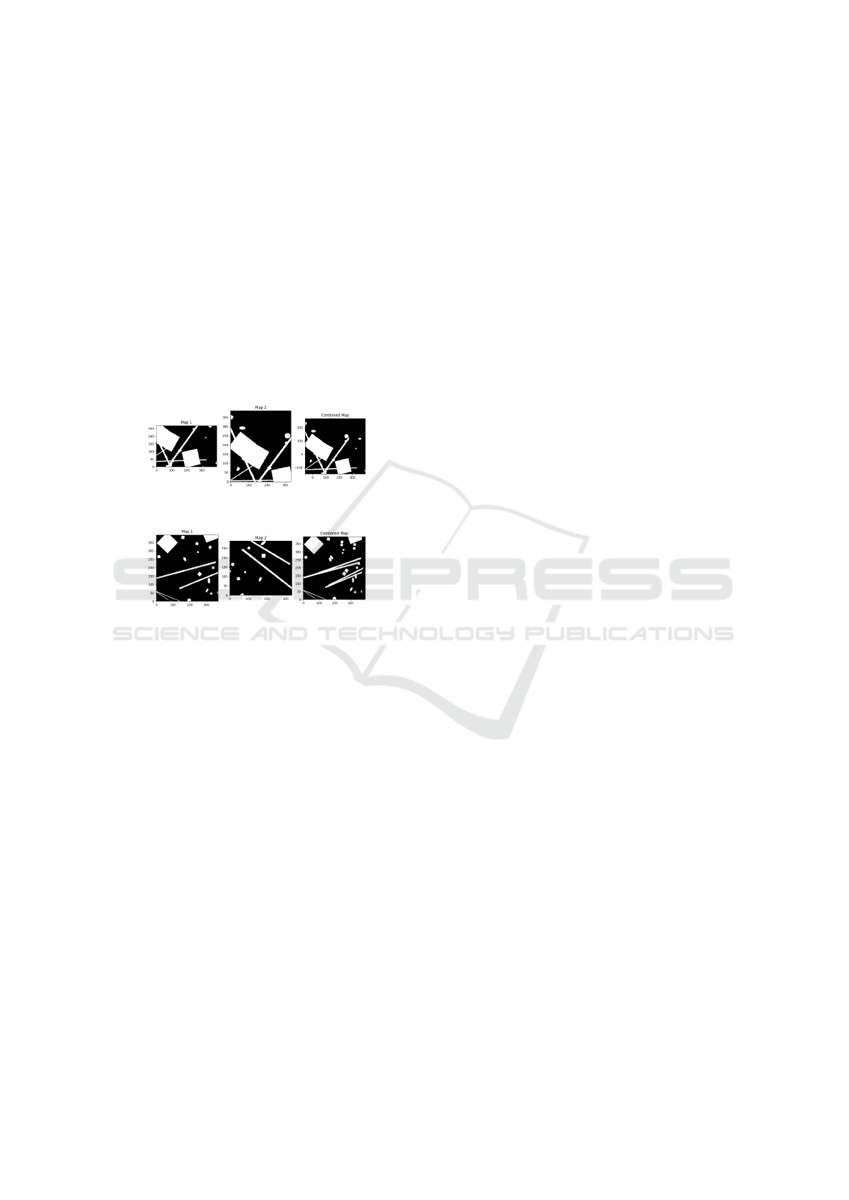
An example can be seen in Figures 3 and 4.
Figure 3: Keypoints extracted from a pair of maps.
After identifying the correspondences, it is nec-
essary to calculate the transformation that aligns the
maps. This transformation may include transla-
tion and rotation and is obtained through the func-
tion cv2.estimateAffinePartial2D, which uses
ICINCO 2025 - 22nd International Conference on Informatics in Control, Automation and Robotics
188
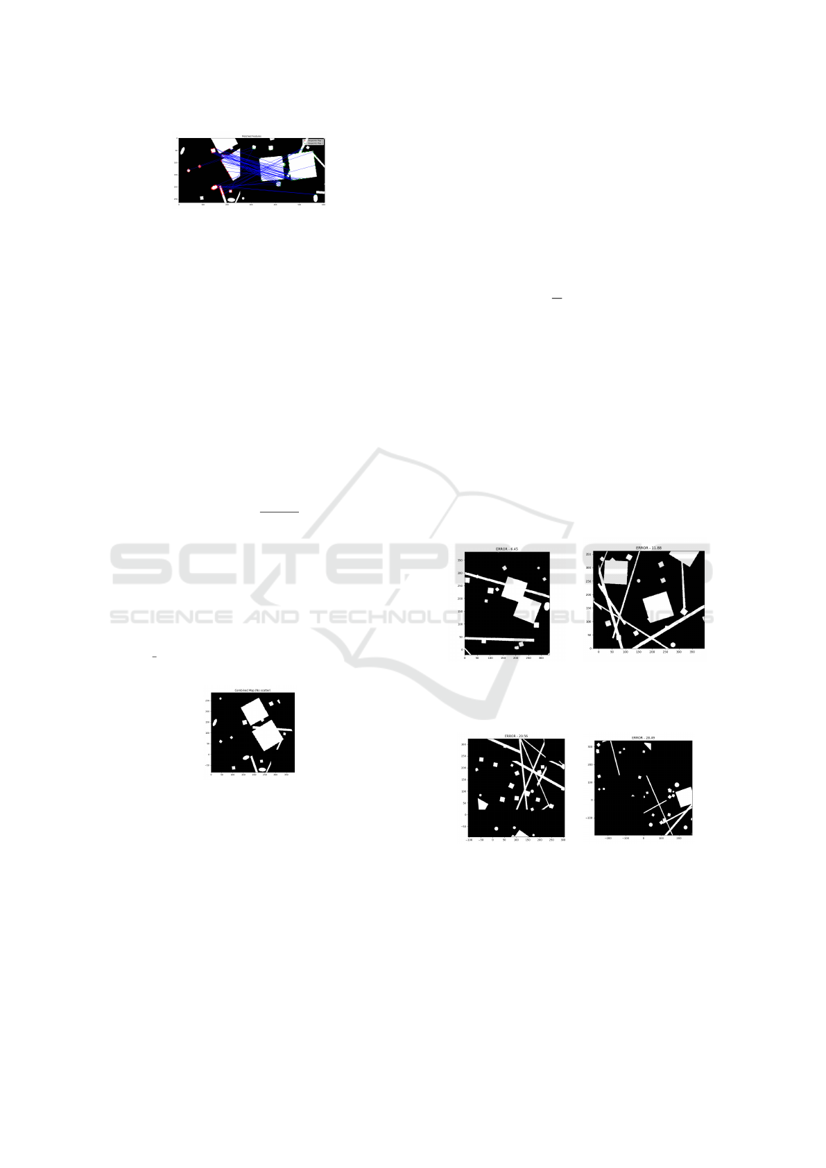
Figure 4: Lines illustrating similarities on connections be-
tween the maps, represented side-by-side.
the RANSAC method to minimize the impact of erro-
neous correspondences. The resulting transformation
is described by:
1 0 dx
0 1 dy
where dx and dy are the translations along the x and y
axes, respectively. The rotation angle θ is calculated
from the parameters of the transformation matrix. For
example, if the obtained transformation matrix is:
M =
cos(θ) −sin(θ) dx
sin(θ) cos(θ) dy
the angle can be calculated as:
θ = arctan
M[1, 0]
M[0, 0]
Here, the notation M[i, j] refers to the element in
the i-th row and j-th column of matrix M, follow-
ing zero-based indexing conventions common in pro-
gramming languages such as Python.
Once the transformation is determined, the next
step is to apply the rotation to the second map
and overlay the two maps using the function
overlay maps. The merged map for the maps on the
Figure 3 can be seen in Figure 5
Figure 5: Final result of the map merging process.
Finally, considering the scalability of the process,
the fusion should be capable of handling maps of dif-
ferent sizes. For this, interpolation techniques and
scaling adjustments can be applied to ensure the infor-
mation is correctly combined, even when the maps are
captured at different resolutions or dimensions. This
modular approach makes map fusion scalable and ro-
bust, making it applicable to a wide range of scenar-
ios, from robotics applications to geospatial mapping.
3.4 Overlap Precision Detection
Before applying the transformation and overlaying
the maps, evaluating the accuracy of the fusion per-
formed is essential. For this, we calculate the mean
absolute error between the overlapping areas of the
maps, which provides a quantitative measure of the
quality of the fusion. The following formula defines
the error:
Error =
1
N
N
∑
i=1
|I
1
[i] − I
2
[i]|
where I
1
and I
2
are the pixel values in the overlapping
areas, and N is the total number of pixels in the over-
lap region. A low mean error indicates that the maps
have been successfully fused and that the information
is aligned accurately.
This error metric is used purely for evaluating the
quality of the alignment after the transformation is es-
timated, not for optimization. The Mean Absolute Er-
ror was chosen for its straightforward interpretation in
occupancy grids, where it directly represents the av-
erage difference in pixel values, providing a clear and
computationally inexpensive measure of fusion qual-
ity.
Figure 6: Good align-
ment with a low error of
6.43 (mean pixel differ-
ence).
Figure 7: Minor mis-
alignment with an error
of 11.88.
Figure 8: Noticeable
misalignment with an
error of 20.56, nearing
the discard threshold.
Figure 9: Poor align-
ment with a high error
of 28.49, indicating a
failed fusion.
To better illustrate the impact of the error metric,
Figures 6, 7, 8, and 9 show examples of map over-
lays with different mean absolute error values. These
figures provide visual insight into how the increasing
error affects the accuracy of the fusion:
ORB-Based Map Fusion with Position Transformation for Enhanced Pairwise Connection
189
• In Figure 6, the error is relatively low (6.43), in-
dicating that the maps have been well aligned, and
the overlap area shows minimal discrepancies be-
tween the pixel values.
• As the error increases, as seen in Figure 7 (error
= 11.88), slight misalignments between the maps
begin to appear. While the fusion is still some-
what accurate, the overlapping areas exhibit mi-
nor differences, which remain nearly impercepti-
ble to the human eye.
• In Figure 8 (error = 20.56), the discrepancies be-
come more noticeable and start to affect the preci-
sion of the fusion significantly. At this point, the
error reaches a value where the alignment is no
longer reliable, and the map should be considered
for discarding.
• Finally, in Figure 9 (error = 28.49), the misalign-
ment becomes more pronounced, with substantial
differences between the overlapping areas. From
this point onwards, the error reaches a threshold
where the maps must be discarded due to poor
alignment and unreliable fusion results.
Thus, the error remains nearly imperceptible up to
around 20. Beyond this threshold, the fusion quality
deteriorates significantly. This provides a clear met-
ric for determining when to consider or discard maps
based on their mean absolute error.
In addition to the mean absolute error, feature de-
tection and the quality of the matches between the de-
scriptors are crucial for the success of the fusion. The
effectiveness of the matching algorithm, such as BF-
Matcher, and the precision in identifying features di-
rectly influence the quality of the calculated transfor-
mation. If a significant number of erroneous matches
are identified, it is possible that the fusion result may
not be satisfactory, even if the mean absolute error is
low.
To enhance the robustness of the fusion process,
additional techniques are employed, such as cross-
validation of matches and the application of filters to
eliminate outliers. These methods ensure that only
the most reliable matches are included in the final fu-
sion. This comprehensive approach improves the ac-
curacy of the map fusion and increases the system’s
resilience to noise and variations in the input data.
3.5 Robot Position Transformation
When merging two maps from different robots, it is
essential to accurately transform the robot positions to
the unified map (Martinelli et al., 2023). This process
ensures that each robot’s position is correctly placed
relative to the newly aligned map. In this work, the
transformation of robot positions is achieved by using
the same homography matrix used for map alignment.
Given a robot’s initial position (x
r
, y
r
) in its lo-
cal map, the transformed position in the unified map
(x
′
r
, y
′
r
) is calculated by applying the homography ma-
trix:
x
′
r
y
′
r
1
=
h
11
h
12
h
13
h
21
h
22
h
23
0 0 1
x
r
y
r
1
This transformation ensures that the robot’s posi-
tion in the unified map reflects the correct orientation
and scale of the newly fused environment. An exam-
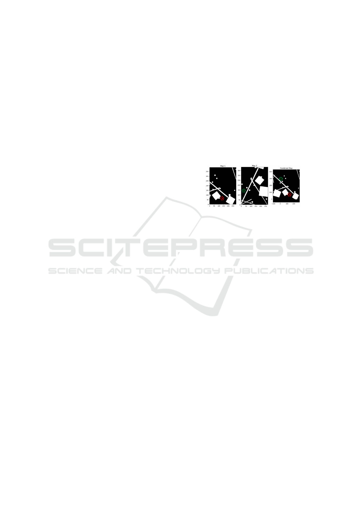
ple can be seen in Figure 10, with robots being repre-
sented by the colored dots.
Figure 10: Robots positions transformation.
Ensuring the accurate transformation of robot po-
sitions is critical for several reasons. First, it allows
for precise coordination between the robots within the
shared environment, enabling them to communicate
and make decisions based on their relative locations
(Wang et al., 2023). Furthermore, in navigation and
obstacle avoidance tasks, having correct position in-
formation is crucial to avoid collisions and plan effi-
cient paths (Martinelli et al., 2023). Lastly, this pro-
cess guarantees that any subsequent actions or up-
dates in the environment (placing landmarks or inter-
acting with objects) are executed in the correct spatial
context, preserving the integrity of the merged map.
3.6 Computational Efficiency
The computational efficiency of the proposed map
merging algorithm is driven by its ability to optimize
the processing of large-scale maps. Despite process-
ing the entire map initially, the algorithm is designed
to reduce overall computation time by halting the pro-
cess when certain conditions indicate that the result-
ing map alignment would be suboptimal. This feature
allows the system to avoid unnecessary processing
when there is no clear benefit to refining poor matches
further.
One key factor contributing to this efficiency is
the algorithm’s ability to reject maps that do not meet
quality thresholds before completing a full merge. In
cases where the matching quality is insufficient, the
algorithm terminates early, preventing further waste
ICINCO 2025 - 22nd International Conference on Informatics in Control, Automation and Robotics
190
of computational resources. This early termination
mechanism ensures that computational power is only
spent on map alignments, likely contributing to an ac-
curate final map.
Additionally, by efficiently handling cases of poor
overlap or misalignment, the algorithm ensures that
high-quality maps are not replaced or corrupted by
low-confidence merges. Figures 11 and 12 show ex-
amples of a successful merge versus a case where
early termination was beneficial, visually emphasiz-
ing the effectiveness of the selective merging pro-
cess. This selective merging process improves reli-
ability and significantly reduces the time spent on un-
necessary calculations, particularly valuable in real-
time operations or when working with extensive map
datasets.
Figure 11: Succesful merge, with an error of 5.47.
Figure 12: Unsuccesful merge, with an error of 33.78.
In summary, the algorithm’s efficiency lies in its
ability to streamline processing by avoiding the full
computation of maps unlikely to improve the over-
all result. This targeted approach reduces the compu-
tational load while maintaining the integrity of well-
matched sections, thus balancing speed and accuracy
in large-scale map fusion tasks.
4 EVALUATION AND ANALYSIS
Two distinct experiments were conducted to assess
the performance of the proposed map fusion algo-
rithm based on ORB. The first experiment aims to
evaluate the algorithm’s ability to detect the quality
of the map merging, particularly focusing on its accu-
racy in identifying false positives. This test will also
inform future algorithm adaptations into a cyclical
system for continuous operation and real-time map
updates. The second experiment visually compares
the results of the automatic map fusion performed by
the algorithm with manually merged maps, providing
a qualitative analysis of its performance.
4.1 Comparison of Automatic and
Manual Merging
This experiment aims to evaluate the qualitative per-
formance of the proposed ORB-based map fusion al-
gorithm by comparing its results with those of manu-
ally merged maps. The goal is to visually assess how
well the algorithm aligns the maps regarding struc-
tural consistency, continuity, and overall accuracy.
For this comparison, several pairs of maps were
selected, each with varying levels of complexity, ro-
tation, and translation. The chosen maps included
features such as walls, corridors, and obstacles com-
monly found in robotic occupancy grids. Each map
pair was processed using two methods:
1. Automatic Fusion: The proposed algorithm was
applied to merge the maps without manual inter-
vention. The algorithm used ORB feature match-
ing to detect key points and estimate the transfor-
mation required for alignment.
2. Manual Fusion: A single human operator con-
ducted a manual fusion process in parallel. The
manual fusion involved identifying overlapping
regions between the two maps and aligning them
by visually adjusting their rotation and translation.
The results of both methods were displayed side
by side to facilitate a direct comparison. Key qualita-
tive aspects were analyzed visually, including:
• Alignment Precision: The visual degree to which
the structural elements of the maps, such as walls
and obstacles, appeared to be correctly aligned.
• Continuity of Features: The smoothness and
consistency of the merged map, particularly at
the boundaries between the original maps, are as-
sessed through visual inspection.
• Visual Accuracy: The merged map’s overall co-
herence, focusing on preserving critical map fea-
tures without distortion, evaluated based on visual
assessment.
Figures 13 and 14 show the visual outputs of the
automatic and manual fusion, respectively. As ob-
served in this example, the automatic fusion demon-
strated the ability to understand the connection be-
tween the maps even with limited overlapping ar-
eas, indicating its robustness in handling sparse data.
However, this particular example exhibited a slight
imprecision due to the lack of information. This com-
parison is one of several tests conducted using various
map pairs to evaluate the algorithm’s performance un-
der different scenarios.
ORB-Based Map Fusion with Position Transformation for Enhanced Pairwise Connection
191
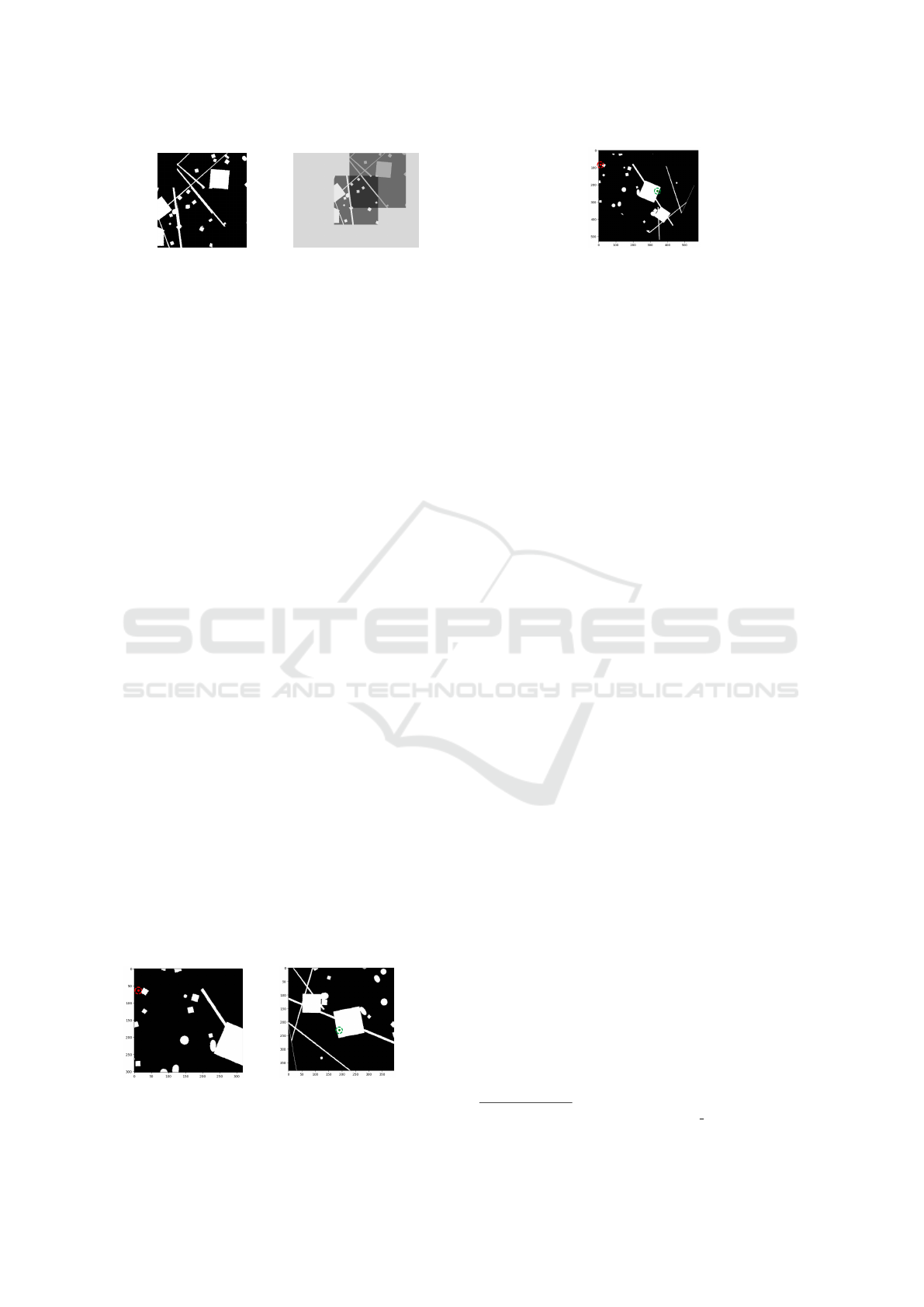
Figure 13: Automatic fu-
sion.
Figure 14: Manual fu-
sion.
4.2 Robot Positioning Accuracy Test
In this section, we evaluate the capability of the pro-
posed map fusion algorithm to position robots within
the generated map accurately. The positioning accu-
racy is crucial for effective navigation and operation
of robotic systems in real-world environments. This
test assesses how well the algorithm can align the
merged maps with the actual positions of the robots
based on randomly assigned coordinates.
The experimental setup involved several pairs of
patches extracted from a larger map, with robot posi-
tions randomly assigned within each patch. The steps
taken during the testing process were as follows:
1. Patch Extraction: Randomly extract two patches
from a larger map, each containing a robot placed
at a random position within the patch.
2. Map Fusion: Apply the proposed algorithm to
merge the extracted patches into a single map.
3. Position Estimation: After merging, estimate the
positions of the robots within the fused map based
on the algorithm’s output.
4. Visual Assessment: Compare the estimated po-
sitions visually in the merged map to evaluate the
algorithm’s accuracy.
The results of the robot positioning accuracy test
are illustrated in Figures 15, 16, and 17. The first two
figures display the individual patches with randomly
assigned robots. In contrast, the third figure shows the
final merged map and the calculated positions of both
robots. The accuracy of the algorithm can be visually
assessed in the merged map. In all conducted tests,
the algorithm demonstrated exceptional performance
in accurately transforming the positions of the robots
within the merged maps.
Figure 15: Patch 1 with
robot in red.
Figure 16: Patch 2 with
robot in green.
Figure 17: Final merged map with estimated robot posi-
tions.
5 CONCLUSION
This study presented an algorithm for map fusion uti-
lizing ORB feature matching, specifically designed
to merge robotic occupancy grids. The algorithm
demonstrates significant potential for improving the
reliability and efficiency of robotic navigation sys-
tems.
One of the key advantages of the proposed algo-
rithm is its capability to operate with maps of varying
sizes and orientations effectively. This flexibility is
particularly beneficial in multi-robot systems, where
different robots may generate maps under different
conditions. By accurately merging these maps, the
algorithm enables robots to collaborate and navigate
within a unified environment representation, enhanc-
ing their ability to perform coordinated tasks.
Moreover, the algorithm can estimate robot posi-
tions within the fused maps, even with limited over-
lapping areas. This positioning accuracy is crucial for
runtime decision-making and navigation in dynamic
environments.
The efficiency of the ORB feature matching
method further distinguishes this algorithm from con-
ventional approaches. Its computational speed allows
for real-time processing, making it suitable for dy-
namic applications where timely responses are essen-
tial.
Overall, the results indicate that the proposed al-
gorithm is a valuable tool for enhancing the capabili-
ties of autonomous robots. The successful integration
of maps is vital for enabling these systems to operate
effectively in complex environments.
All experimental data, including generated maps
and test results, can be found in a public repository
1
.
This repository is a resource for further exploring and
validating the proposed method in robotic mapping
and navigation tasks.
Future work on the proposed map fusion al-
gorithm could focus on several enhancements and
practical applications. One significant improvement
would be to adapt the algorithm to handle occupancy
grids with values ranging from -1 to 255 rather than
1
https://github.com/LucasZick/map fusion
ICINCO 2025 - 22nd International Conference on Informatics in Control, Automation and Robotics
192

being limited to binary values of 0 and 1. This exten-
sion would allow the algorithm to incorporate more
nuanced information about the environment, such as
varying degrees of uncertainty or likelihood of obsta-
cles.
Additionally, it would be beneficial to implement
the algorithm on real robotic systems operating in
real-world environments. Testing in practical settings
would provide valuable insights into the algorithm’s
performance under dynamic conditions and with ac-
tual sensor data. This approach could lead to further
refinements and optimizations, enhancing the algo-
rithm’s robustness and applicability in diverse robotic
applications.
Exploring these avenues would contribute to de-
veloping more sophisticated multi-robot systems, ul-
timately improving their efficiency and effectiveness
in navigating complex environments.
ACKNOWLEDGEMENTS
The project is supported by the National Council for
Scientific and Technological Development (CNPq)
under grant number 407984/2022-4; the Fund for
Scientific and Technological Development (FNDCT);
the Ministry of Science, Technology and Innovations
(MCTI) of Brazil; Brazilian Federal Agency for Sup-
port and Evaluation of Graduate Education (CAPES);
the Araucaria Foundation; the General Superinten-
dence of Science, Technology and Higher Education
(SETI); and NAPI Robotics.
REFERENCES
Ahmed, M. F., Fr
´
emont, V., and Fantoni, I. (2024). Ac-
tive collaborative visual slam exploiting orb features.
arXiv preprint arXiv:2407.05453.
Ahmed Jalil, B. and Kasim Ibraheem, I. (2023). Multi-robot
slam using fast lidar odometry and mapping. Designs,
7(5):110.
Arai, T., Pagello, E., Parker, L. E., et al. (2002). Advances
in multi-robot systems. IEEE Transactions on robotics
and automation, 18(5):655–661.
Chakraa, H., Gu
´
erin, F., Leclercq, E., and Lefebvre, D.
(2023). Optimization techniques for multi-robot task
allocation problems: Review on the state-of-the-art.
Robotics and Autonomous Systems, page 104492.
Cong, Y. (2024). Image stitching technology for police
drones using an improved image registration method
incorporating orb algorithm. Informatica, 48(2).
Gautam, A. and Mohan, S. (2012). A review of research
in multi-robot systems. In 2012 IEEE 7th interna-
tional conference on industrial and information sys-
tems (ICIIS), pages 1–5. IEEE.
Karami, E., Prasad, S., and Shehata, M. (2017). Im-
age matching using sift, surf, brief and orb: per-
formance comparison for distorted images. arXiv
preprint arXiv:1710.02726.
Martinelli, D., Kalempa, V. C., and de Oliveira, A. S.
(2023). Map merge and accurate localization in
multi-robot systems in real environments. In Iberian
Robotics conference, pages 26–38. Springer.
Mukhopadhyay, S., Umari, H., and Koirala, K. (2023).
Multi-robot map exploration based on multiple
rapidly-exploring randomized trees. SN Computer
Science, 5(1):31.
Sabry, E. S., Elagooz, S., El-Samie, F. E. A., El-Bahnasawy,
N. A., and El-Banby, G. M. (2024). Sift and orb per-
formance assessment for object identification in dif-
ferent test cases. Journal of Optics, 53(3):1695–1708.
Sing
´
eis, R. (2024). Check for performance analysis of
orb-slam in foggy environments rita sing
´
eis, sedat
dogru (), and lino marques institute of systems and
robotics, department of electrical and computer. In
Robot 2023: Sixth Iberian Robotics Conference: Ad-
vances in Robotics, Volume 1, volume 1, page 209.
Springer Nature.
Stathoulopoulos, N., Koval, A., Agha-mohammadi, A.-a.,
and Nikolakopoulos, G. (2023). Frame: Fast and ro-
bust autonomous 3d point cloud map-merging for ego-
centric multi-robot exploration. In 2023 IEEE interna-
tional conference on robotics and automation (ICRA),
pages 3483–3489. IEEE.
Va
ˇ
s
ˇ
c
´
ak, J. and Herich, D. (2023). Map merging for multi-
robotic applications. In 2023 IEEE 21st World Sympo-
sium on Applied Machine Intelligence and Informatics
(SAMI), pages 000021–000026. IEEE.
Wang, M., Cong, M., Du, Y., Liu, D., and Tian, X. (2023).
Multi-robot raster map fusion without initial rela-
tive position. Robotic Intelligence and Automation,
43(5):498–508.
Wu, K. (2023). Creating panoramic images using orb fea-
ture detection and ransac-based image alignment. Ad-
vances in Computer and Communication, 4(4):220–
224.
Yan, H., Wang, J., and Zhang, P. (2023). Application of
optimized orb algorithm in design ar augmented real-
ity technology based on visualization. Mathematics,
11(6):1278.
ORB-Based Map Fusion with Position Transformation for Enhanced Pairwise Connection
193
