
Intelligent Satellite Image Classification Using Deep Convolutional
Neural Networks
Manoj Bhaskar
1
, Chetan Barde
1
, Prakash Ranjan
1
Nawneet Kumar
1
and Sujit Kumar
2
1
Dept. of Electronics and Communication Engineering, Indian Institute of Information Technology Bhagalpur, Bhagalpur,
Bihar, India
2
Dept. of Electrical Engineering, Government Engineering College Banka, Bihar Engineering University, Science,
Technology and Technical Education Department, Bihar, India
Keywords:
Satellite Image, Classification, Deep Learning, Batch Normalization.
Abstract:
Image classification plays a key role in remote sensing, image analysis, and pattern recognition. Detecting
and classifying objects in satellite images is vital for applications like marine monitoring, land use planning,
ecological studies, and military operations. Satellite images, with their rich spatial and temporal information,
help address many real-world challenges. However, classifying these images is challenging due to limited data
availability, varying quality, and uneven distribution. Deep learning (DL) algorithms have become popular
for satellite image classification because of their effectiveness in tasks such as land-use planning, disaster
response, and resource management. This study introduces a deep convolutional neural network (DCNN)
model combined with batch normalization (BN) for classifying satellite images. The dataset includes images
from remote sensing satellites categorized into four classes: cloudy regions, deserts, water bodies, and green
areas. CNNs are well-suited for image processing, as they automatically extract key features like edges and
textures. Batch normalization improves training by stabilizing inputs within the network layers, making the
process faster and more efficient. Our proposed model demonstrates high accuracy in classifying satellite
images, achieving an overall performance of 94.50%, outperforming existing methods. This shows its potential
for real-world applications.
1 INTRODUCTION
Satellite image processing involves analyzing data
collected by Earth-orbiting satellites using sensors
like cameras and radar. These images provide valu-
able insights into weather, land use, and more (Voigt,
2007) (Nguyen, 2019). A major challenge is handling
the vast amount of data generated by these sensors,
which is too complex for manual processing. Ad-
vanced algorithms are used to interpret the images,
applying techniques like enhancement, classification,
and feature extraction (Fu, 2018). These methods
are widely used in fields like environmental moni-
toring, agriculture, and urban planning, helping track
changes in crops, urban areas, and forests (Singh,
2022) (Padmanaban, 2019).
Satellite image processing involves analyzing data
captured by Earth-orbiting satellites using sensors
like cameras and radar. These images provide valu-
able insights into weather patterns, land use, and
other critical aspects of Earth’s surface. However,
the sheer volume of data generated by satellite sen-
sors presents a major challenge. Advanced computer
algorithms are necessary to process and interpret this
complex data effectively. Key techniques include im-
age enhancement, feature extraction, and classifica-
tion. Feature extraction identifies specific elements in
an image, such as roads or buildings, making it useful
for applications in environmental monitoring, agri-
culture, and urban planning. For example, satellite
images are used to track crop health, urban growth,
and deforestation rates. With technological advances,
satellite image processing continues to play a vital
role in managing Earth’s resources.
Deep learning has emerged as a powerful tool for
satellite image classification. Inspired by the human
brain, deep learning uses neural networks with multi-
ple layers—input, hidden, and output layers (Diker,
2022). These networks process data through inter-
connected neurons using weights, biases, and acti-
vation functions like ReLU, sigmoid, or tanh. This
354
Bhaskar, M., Barde, C., Ranjan, P., Kumar, N. and Kumar, S.
Intelligent Satellite Image Classification Using Deep Convolutional Neural Networks.
DOI: 10.5220/0013616500004664
Paper published under CC license (CC BY-NC-ND 4.0)
In Proceedings of the 3rd International Conference on Futuristic Technology (INCOFT 2025) - Volume 3, pages 354-359
ISBN: 978-989-758-763-4
Proceedings Copyright © 2025 by SCITEPRESS – Science and Technology Publications, Lda.

structured approach enables deep learning models to
extract meaningful features and classify satellite im-
ages efficiently. Several studies demonstrate the ad-
vancements in satellite image processing using deep
learning. (Tripodi, 2022) developed an automated
pipeline for 3D reconstruction of landscapes from
high-resolution satellite images. This method used
convolutional neural networks (CNNs) to extract se-
mantic features and classify data into 16 categories,
producing detailed 3D maps. Similarly, (Anggi-
ratih, 2019) combined the ZFNet CNN architecture
with the Random Forest algorithm to enhance fea-
ture extraction and classification. While the model
achieved 87.5% accuracy for large vessel detection,
it struggled with smaller vessels, achieving less than
50% accuracy. (Munirah Alkhelaiwi, 2021) intro-
duced privacy-preserving deep learning (PPDL) to
safeguard sensitive satellite image data. Their ap-
proach allowed CNN models to train directly on en-
crypted data without significant computational over-
head. Testing on a dataset from Saudi Arabia demon-
strated that the method effectively balanced data util-
ity and privacy. (Ghazaleh Serati, 2022) applied a
conditional generative adversarial network (CGAN)
to extract building footprints in Yangon City, Myan-
mar, using optical satellite images. Their model
achieved 71% completeness, 81% correctness, and
an F1 score of 69% for building footprint extraction,
demonstrating the potential of CGANs for urban map-
ping tasks. (Ashwini, 2023) developed an ensem-
ble method for classifying satellite images into cat-
egories such as Cloudy, Desert, Water, and Green
areas. The approach combined confidence scores
from four classifiers—Decision Tree, Random For-
est, Gaussian Na
¨
ıve Bayes, and Support Vector Clas-
sifier—achieving an overall accuracy of 92%. (T. Yo-
gesh, 2024) used a dataset of 5,631 satellite images
to classify cloud-covered areas, deserts, green land-
scapes, and water bodies. They employed the VGG-
16 CNN architecture, achieving high validation accu-
racy and showcasing the potential of deep learning for
satellite image classification.
These advancements highlight the importance of
deep learning in improving the accuracy and effi-
ciency of satellite image processing. Techniques like
CNNs, ensemble classifiers, and generative networks
are continuously pushing the boundaries of what can
be achieved, making satellite image analysis a crucial
tool for addressing real-world challenges.
This research focuses on improving satellite im-
age classification using a DCNN combined with batch
normalization (BN). DCNN have emerged as a piv-
otal tool in modern machine learning, particularly for
tasks involving image and signal processing. Their
ability to automatically extract and learn hierarchi-
cal features from raw input data makes them highly
effective for complex pattern recognition problems.
DCNN leverage multiple convolutional layers to cap-
ture intricate spatial and temporal relationships in the
data. BN enhances this process by keeping the fea-
ture distributions stable, which helps the model train
faster and more effectively. Together, DCNN and
BN enable the model to handle large and complex
datasets while ensuring accurate results. The model
is designed to classify satellite images into four cat-
egories: water bodies, green areas, cloudy regions,
and deserts. Experimental results show that the pro-
posed model achieves high accuracy in classification.
The study also compares its performance with other
deep learning methods, demonstrating that the pro-
posed approach is more effective.
The study presents a DCNN model combined with
batch BN to enhance the classification of satellite im-
ages. CNNs are effective for image classification
as they automatically extract important features from
images and classify them accurately. Batch normal-
ization improves the learning process by ensuring the
features maintain consistent distributions, which sta-
bilizes and speeds up the training. This combination
helps the model learn strong and reliable features, en-
abling accurate classification of large and complex
image datasets. The model successfully categorizes
satellite images into four types: water bodies, green
areas, cloudy areas, and deserts. The proposed model
achieves high accuracy, which is validated by exper-
imental results. The model is also compared with
other deep learning methods to demonstrate its ef-
fectiveness. The paper is organized as follows: Sec-
tion 1 provides an introduction to various satellite im-
age classification approaches. Section 2 outlines the
proposed methodology for satellite image classifica-
tion. Section 3 presents the results and discussion of
the classification model, and Section 4 concludes the
work.
2 DATA DESCRIPTION
This study used the RSI-CB256 dataset for satel-
lite image classification. The dataset is publicly
available online and referenced in (Available online,
2022). Fig. 1. shows sample images from the dataset,
which contains 2,000 satellite images evenly divided
into four categories: 500 images each for cloudy re-
gions, desert areas, green areas, and water bodies.
These categories are labeled as follows: cloudy re-
gions are Class 1, desert areas are Class 2, green areas
are Class 3, and water bodies are Class 4.
Intelligent Satellite Image Classification Using Deep Convolutional Neural Networks
355
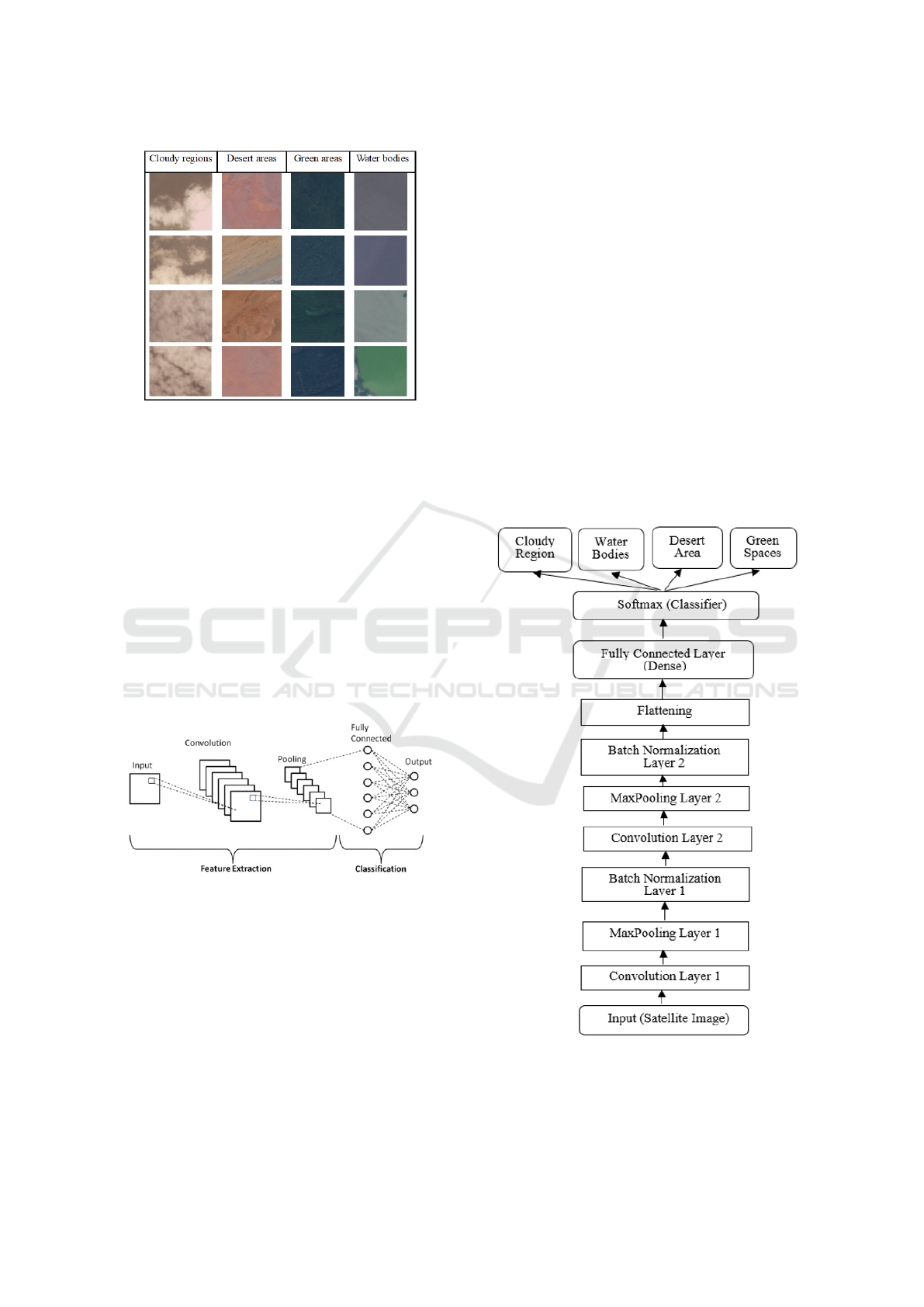
Figure 1: Samples of satellite images from Dataset-RSI-
CB256.
3 METHODOLOGY
This research focuses on classifying satellite images
into four types of terrain using a DCNN model com-
bined with BN. The process starts with a satellite im-
age as input, which is then classified into one of the
four terrain categories. The methodology involves
three steps: pre-processing the images, extracting fea-
ture maps, and classifying the images based on these
features. Fig. 2. illustrates the basic structure of the
CNN model, which includes three main layers: con-
volutional layers for feature extraction, pooling layers
for reducing data size, and fully connected layers for
final classification (Ozbay, 2023) (Onal, 2020).
Figure 2: Basic architecture of CNN
The framework of the proposed model is depicted
in Fig. 3. It begins by processing the input image
as a matrix. The convolutional layer extracts features
from the image by sliding filters across it, perform-
ing matrix multiplications at each position, and creat-
ing a feature map that highlights specific characteris-
tics of the image. Next, the pooling layer reduces the
size of the feature map while retaining essential infor-
mation, often using max pooling to capture the most
significant values. The batch normalization layer sta-
bilizes the inputs across layers by normalizing them
based on batch mean and variance (Yamashita, 2018)
(Narin, 2021) This helps mitigate internal covariate
shifts, speeds up convergence, allows for higher learn-
ing rates, reduces overfitting (often eliminating the
need for dropout), and improves overall classification
performance, particularly for satellite image classifi-
cation tasks. The flattening layer then converts the
matrix data from the previous layers into a single vec-
tor, making it suitable for processing in fully con-
nected layers. The fully connected layer processes
this vector by associating it with learned weights and
applying an activation function, enabling the model
to identify high-level features necessary for classifi-
cation. Finally, the output layer classifies the input
image into specific categories. It uses fully connected
neurons to predict class probabilities and applies a
SoftMax classifier at the end to select the category
with the highest probability as the model output. The
DCNN architecture, with BN, is designed for accu-
rate classification, effectively mapping complex im-
age data into categories.
Figure 3: The framework of the proposed model.
INCOFT 2025 - International Conference on Futuristic Technology
356
4 EVALUATION OF THE
PROPOSED MODEL
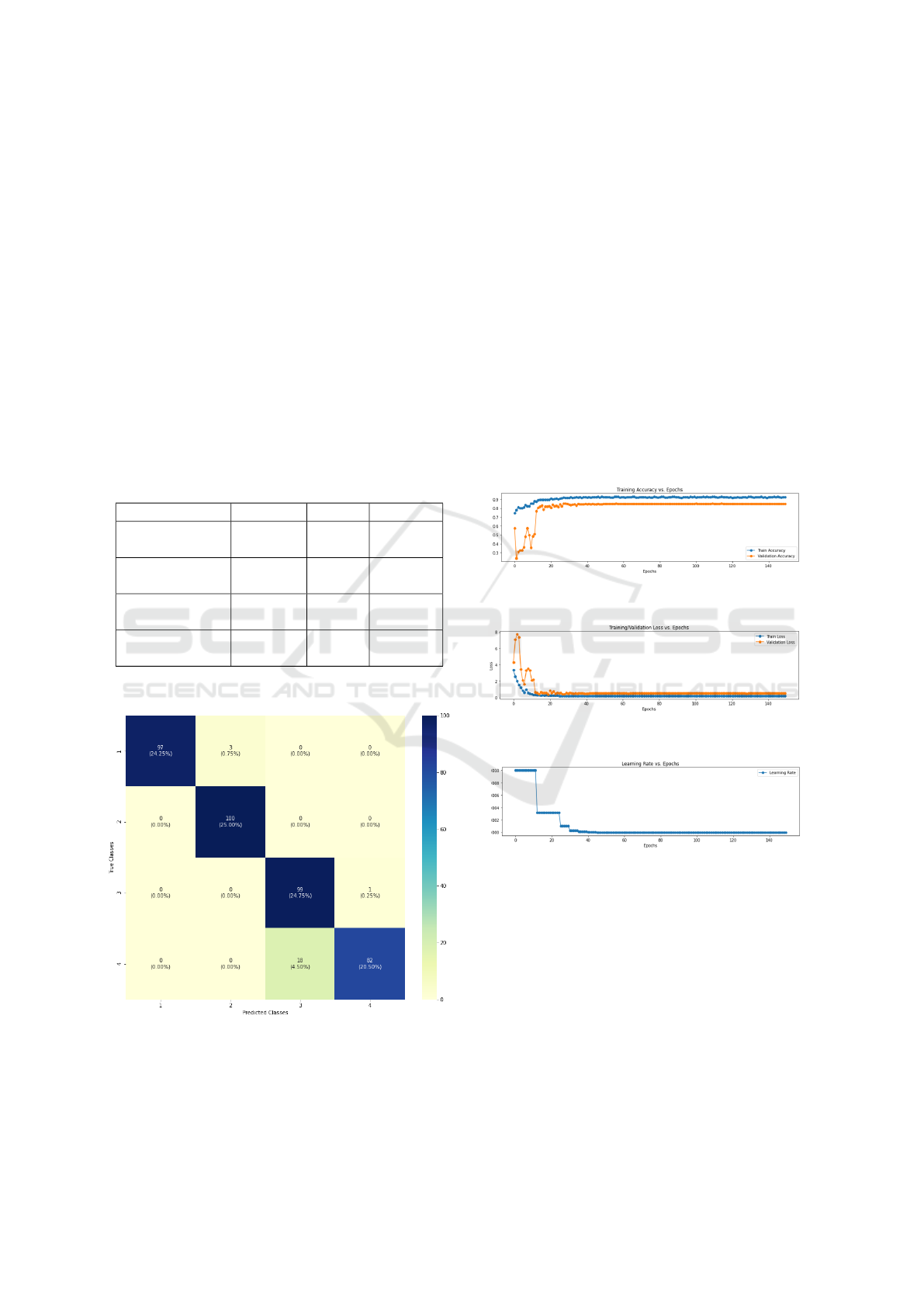
The performance of the proposed model is mea-
sured using metrics like Accuracy, Precision, Recall,
and F1 score, all derived from a multi-class confusion
matrix (Musali, 2024). The confusion matrix pro-
vides a detailed evaluation of the model performance
by comparing predicted labels (shown in rows) with
true labels (shown in columns). It highlights correct
predictions on its diagonal and is essential for calcu-
lating the key performance metrics. Figure 4 presents
the confusion matrix for the proposed CNN model,
showing an accuracy of 94.50%. Table 1. summarizes
the performance metrics, including the precision, re-
call, and F1 score, demonstrating the effectiveness of
the model in classifying satellite images accurately.
Table 1: Performance score of the proposed model
Precision Recall F1-score
Cloudy regions
(Class 1)
1.00 O.97 0.98
Desert areas
(Class 2)
0.97 1.00 0.99
Green areas
(Class 3)
0.85 0.99 0.91
Water bodies
(Class 4)
0.99 0.82 0.90
Figure 4: Confusion matrix of the proposed model.
Fig. 5. shows the accuracy of the developed CNN
model, with the best training and validation accuracy
achieved at 150 epochs. This plot illustrates how
the model’s accuracy improves as it trains, reaching
92.80%. Fig. 6. presents the model’s loss, which
shows the decrease in the error between the model’s
predictions and the actual target values on the training
data. The loss stabilizes at around 150 epochs, reach-
ing 84.75%, indicating that the model is learning ef-
fectively. Together, these figures reflect the model’s
learning process and how it improves over time. Fig.
7. shows the Learning Rate vs. Epoch plot, which
tracks how the learning rate changes during train-
ing. The learning rate controls the size of adjust-
ments the model makes to its weights based on errors.
If the learning rate is too high, the model can make
large, unstable changes, while a low rate can slow
down progress. Adjusting the learning rate through-
out training, using methods like learning rate decay,
helps the model find a balance between fast learning
and stability, ultimately improving performance and
accuracy
Figure 5: Model accuracy of the proposed model.
Figure 6: Model loss of the proposed model.
Figure 7: Model learning rate of the proposed model.
5 TRAINING, VALIDATION AND
TESTING OF THE MODEL
The dataset used in this study consists of remote
sensing satellite images, which are divided into four
categories: cloudy regions, desert areas, water bodies,
and green spaces. To prevent overfitting, a dropout
rate of 0.2 is applied in the hidden layer, which helps
the model generalize better and speeds up the learn-
ing process. During training, the Adam optimizer is
Intelligent Satellite Image Classification Using Deep Convolutional Neural Networks
357

used to adjust the weights and biases of the model. A
fully connected dense layer with a Softmax activation
function is then used to classify the images into one of
the four categories. The model is implemented using
TensorFlow version 1.0, with 80% of the data used for
training. A small portion of the training data is also
set aside for validation, while the remaining 20% is
reserved for testing the model’s performance.
6 RESULTS AND DISCUSSION
This study introduces a DCNN architecture com-
bined with BN for classifying satellite images. The
dataset used in this study consists of images from re-
mote sensing satellites, categorized into four classes:
cloudy regions, desert areas, water bodies, and green
spaces. The performance of the proposed model
is compared with traditional statistical methods and
other deep learning models. Table 2. shows that our
CNN model achieves the highest accuracy in satel-
lite image prediction, with an accuracy of 94.50%.
In comparison, the RNN, which is often used for
time series forecasting, had lower performance in this
task. The other methods tested, including SVM, Ran-
dom Forest, KNN, Decision Tree, PPDL, VGG16,
ResNet50, and DenseNet121, achieved accuracies of
72.84%, 84.20%, 80.56%, 75.33%, 90.92%, 89.00%,
89.80%, and 90.50%, respectively.
Table 2: Comparison of results with existing methods
Methods Accuracy
(%)
SVM 72.84
Random Forest 84.20
KNN 80.56
Decision Tree 75.33
PPDL Techniques 90.92
VGG16 89.00%
ResNet50 89.80%
DenseNet121 [9] 90.50%
The Proposed Model 94.50%
7 CONCLUSIONS
In this study, a DCNN model with BN is pro-
posed to classify satellite images into four categories:
cloudy regions, desert areas, water bodies, and green
spaces. Satellite images are commonly used to solve
various problems in remote sensing, but classifying
them can be difficult due to issues like data avail-
ability, quality, quantity, and distribution. Traditional
methods often struggle to handle these challenges
accurately. To improve the classification accuracy,
a new approach is introduced that combines feature
generation, feature selection, and model design. The
proposed BN-based CNN model is effective in cap-
turing complex patterns in satellite images, achieving
better results during training and testing compared to
other methods using the same dataset. The results
show that this model is highly effective for satellite
image classification. The study also suggests that fu-
ture research should focus on reducing the model’s
complexity and further improving its performance,
with batch normalization playing a key role in en-
hancing stability and speeding up training.
ACKNOWLEDGMENT
The author would like to thank Dilara Ozdemir for
providing the Satellite Remote Sensing Image dataset
RSI-CB256, which includes categories such as cloudy
regions, desert areas, water bodies, and green areas,
and is available in resources like the GitHub reposi-
tory by Dilara Ozdemir.
REFERENCES
Voigt, Stefan, Thomas Kemper, Torsten Riedlinger, Ralph
Kiefl, Klaas Scholte, and Harald Mehl. (2007). Satel-
lite image analysis for disaster and crisis-management
support. IEEE transactions on geoscience and remote
sensing. vol. 45, no. 6 pp. 1520-1528. IEEE
Nguyen, Thi Mai, Tang-Huang Lin, and Hai-Po Chan
(2019). The environmental effects of urban develop-
ment in Hanoi. Vietnam from satellite and meteoro-
logical observations from 1999–2016. Sustainability.
vol. 11, no. 6 pp. 1768.
Fu, Hualian, Yuan Shen, Jun Liu, Guangjun He, Jinsong
Chen, Ping Liu, Jing Qian, and Jun Li. (2018). Cloud
detection for FY meteorology satellite based on en-
semble thresholds and random forests approach. Re-
mote Sensing, vol. 11, no. 1, pp. 44.
Singh, Kamal Kant, Dhiraj Kumar Singh, Narinder Kumar
Thakur, Sanjay Kumar Dewali, Harendra Singh Negi,
Snehmani, and Varunendra Dutta Mishra. (2022). De-
tection and mapping of snow avalanche debris from
Western Himalaya, India using remote sensing satel-
lite images. Geocarto International. vol. 37, no. 9, pp.
2561-2579.
Padmanaban, Rajchandar, Avit K. Bhowmik, and Pedro
Cabral. (2019). Satellite image fusion to detect chang-
ing surface permeability and emerging urban heat is-
INCOFT 2025 - International Conference on Futuristic Technology
358

lands in a fast-growing city. PloS one, vol. 14, no. 1,
pp. e0208949.
Diker, Fadime, and
˙
Ilker Erkan. (2022). Classification of
satellite images with deep convolutional neural net-
works and its effect on architecture. Eskis¸ehir Tech-
nical University Journal of Science and Technology
A-Applied Sciences and Engineering. vol. 23, pp. 31-
41.
Tripodi, S., N. Girard, G. Fonteix, L. Duan, W. Mapurisa,
M. Leras, F. Trastour, Y. Tarabalka, and L. Laurore
(2022). Brightearth: Pipeline for on-the-fly 3D recon-
struction of urban and rural scenes from one satellite
image. ISPRS Annals of the Photogrammetry. Remote
Sensing and Spatial Information Sciences. vol. 3, pp.
263-270.
Anggiratih, Endang, and Agfianto Eko Putra. (2019). Ship
identification on satellite image using convolutional
neural network and random forest,” IJCCS (Indone-
sian Journal of Computing and Cybernetics Systems),
vol. 13, no. 2, pp. 117-126.
Alkhelaiwi, Munirah, Wadii Boulila, Jawad Ahmad, Anis
Koubaa, and Maha Driss. (2021). An efficient ap-
proach based on privacy-preserving deep learning for
satellite image classification. Remote Sensing. vol. 13,
no. 11 pp. 2021.
Ghazaleh Serati, Amin Sedaghat, Nazila Mohammadi and
Jonathan Li. (2022). Digital surface model generation
from high-resolution satellite stereo imagery based on
structural similarity. Geocarto International. vol. 37,
no. 26, pp. 11390-11419.
Ashwini, K., R. Bhuvaneswari, and Perla Sree Neha.
(2023). Remote Sensing Image Classification Based
on Confidence Score of Ensemble Machine Learning
Classifiers. In 2023 International Conference on Evo-
lutionary Algorithms and Soft Computing Techniques
(EASCT). pp. 1-6. IEEE.
T. Yogesh and S. V. S. Devi. (2024). Enhancing Remote
Sensing Image Classification: A Strategic Integration
of Deep Learning Technique and Transfer Learning
Approach. Second International Conference on Data
Science and Information System (ICDSIS), Hassan,
India, pp. 1-5.
Available online: https://www.kaggle.com/datasets/
mahmoudreda55/satellite-image-classification (ac-
cessed on 20 October 2022).
¨
Ozbay, Erdal, and Muhammed Yıldırım. . (2023). Classifi-
cation of satellite images for ecology management us-
ing deep features obtained from convolutional neural
network models. Iran Journal of Computer Science.
vol. 6, no. 3, pp. 185-193.
¨
Onal, Merve Kesım, Engin Avci, Fatih
¨
Ozyurt, and Ayhan
Orhan. (2020). Classification of minerals using ma-
chine learning methods. In 2020 28th Signal Process-
ing and Communications Applications Conference.
(SIU), pp. 1-4. IEEE.
Yamashita, Rikiya, Mizuho Nishio, Richard Kinh Gian Do,
and Kaori Togashi. (2018). Convolutional neural net-
works: an overview and application in radiology. In-
sights into imaging. vol.9, pp. 611-629.
Narın, Derya, and Tu
˘
gba
¨
Ozge Onur. (2021). Investigation
of the effect of edge detection algorithms in the de-
tection of covid-19 patients with convolutional neural
network-based features on chest x-ray images. In 2021
29th Signal Processing and Communications Applica-
tions Conference, (SIU), pp. 1-4. IEEE.
Ioffe, Sergey. (2015). Batch normalization: Accelerating
deep network training by reducing internal covariate
shift. arXiv preprint arXiv:1502.03167.
Musali, Suresh Kumar, Rajeshwari Janthakal, and
Nuvvusetty Rajasekhar. (2024). Holdout based
blending approaches for improved satellite image
classification. International Journal of Electrical and
Computer Engineering (IJECE) vol. 14, no. 4 (2024):
3127-3136.
Intelligent Satellite Image Classification Using Deep Convolutional Neural Networks
359
