
Comparative Examination of Different Change Detection Methods for
Remote Sensing Imagery
Jambukeshwar Pujari
1,2 a
, Javed Wasim
1 b
and Aprna Tripathi
3 c
1
Department of Computer Engineering and Applications, Mangalayatan University, Aligarh-202146, Uttar Pradesh, India
2
Department of Computer Science and Business Systems, Kolhapur Institute of Technology’s College of
Engineering(Autonomus), Kolhapur, Maharshtra, India
3
Department of Data Science and Engineering, Manipal University, Jaipur, India
Keywords:
Remote Sensing (RS),Change Detection (CD).
Abstract:
Land cover change analysis relies heavily on Change Detection (CD), which is the process of identifying
semantic changes in satellite images taken at different dates. Several methods have been devised to identify
changes in satellite photos. Simple to compute and apply, image differencing doesn’t necessitate data collected
from the ground.This study employs performance for change detection to examine multiple strategies that have
been created by different researchers. Detecting changes in high-resolution satellite pictures is crucial for a
better understanding of land surfaces. Using existing methods, reliably detecting changes in satellite pictures
is a tough undertaking. Datasets utilized in the trials were the OSCD dataset and the SECOND dataset. In
comparison with other techniques, RSCDNet achieved higher accuracy, precision, recall, and F1-score.
1 INTRODUCTION
Change detection, often known as CD, is a method
that is utilized to recognize variations in events, fea-
tures, and patterns on the surface of the ground
throughout the course of time(Qiu et al., 2013). CD
is utilized extensively in a variety of geoscientific do-
mains, including but not limited to urban development
also change monitoring, forest monitoring, environ-
mental disaster prevention and map updating. Be-
cause of their extensive coverage, relevant temporal
resolution, availability at various times and places,
high spectral, spatial, and radiometric resolution, dig-
ital format, and the ability to be processed by com-
puters, remote sensing (RS) data are extremely useful
for the study of temporal and spatial changes in land
cover and land use. In remote sensing photos, changes
in land usage and land cover can be seen as variations
in texture, shape, or gray levels(Bao and Guo, 2004).
Accurate change detection is crucial because of
CD’s significance in land cover/use. So, the efficacy
and precision of the findings are heavily dependent on
the CD method’s capability as well as the quality of
a
https://orcid.org/0000-0003-3422-4515
b
https://orcid.org/0000-0001-8528-4556
c
https://orcid.org/0000-0002-4714-3098
the data utilized to identify changes. In order to pro-
cess the data and generate correct information layers
and change maps, suitable and efficient procedures
are necessary. There have been a number of inves-
tigations into RS CD algorithms(Fatemi Nasrabadi,
2019).
Finding new ways to detect changes in satellite
images is motivating researchers to develop better CD
techniques.In recent times, satellite images have been
enhanced with CD techniques that possess strong
discriminative abilities, leading to improved perfor-
mance(Raza et al., 2022).Supervised and unsuper-
vised CD are the two main categories. Although su-
pervised methods are known to produce better out-
comes, labeling training data manually is a real pain.
However, unsupervised approaches are more com-
monly utilized in real-world applications since they
automatically recognize changes(Fang et al., 2022).
In the present study, recently proposed techniques
for RS CD were selected and investigated their per-
formance on OSCD dataset and SECOND dataset.
344
Pujari, J., Wasim, J. and Tripathi, A.
Comparative Examination of Different Change Detection Methods for Remote Sensing Imagery.
DOI: 10.5220/0013592100004664
Paper published under CC license (CC BY-NC-ND 4.0)
In Proceedings of the 3rd International Conference on Futuristic Technology (INCOFT 2025) - Volume 2, pages 344-350
ISBN: 978-989-758-763-4
Proceedings Copyright © 2025 by SCITEPRESS – Science and Technology Publications, Lda.

2 CHANGE DETECTION
CHALLENGES
Change detection (CD) is a crucial approach for com-
prehending and identifying significant urban trans-
formations through the utilization of available ob-
served Earth data. Change detection is a signifi-
cant application of remotely sensed data and it in-
volves in analyzing more than two repetitive satel-
lite images captured from same geographical earth
area at different time intervals. Change detection
is applied in urban planning assessments, monitor-
ing deforestation in agricultural areas, and managing
disasters, among other applications. In addition to
the temporal variations observed across a land sur-
face that contemporary techniques seek to identify
in remotely sensed images, the spectral characteris-
tics of bi-temporal images correspond to alterations
within the geographical area(Chughtai et al., 2021).
These modifications can be integrated in various man-
ners and provide a detailed examination of the pro-
cedures involved in identifying the permissible alter-
ations. Utilizing these remotely sensed images for
CD presents certain challenges. Initially, there is a
discrepancy in the data acquisition parameters result-
ing from repetitive coverage at brief intervals. Sec-
ondly, the vast array of spectral and statistical fea-
tures present in these images, along with the imbal-
anced and integrated pixel data, represent significant
challenges. The current approaches employ spec-
tral and statistical characteristics that effectively iden-
tify changes. Nonetheless, variations in incident an-
gle lead to changes in the spectral features during
the image acquisition process. The statistical fea-
tures remain constant; thus, data selection is crucial to
mitigate the unwanted disturbances in the variations.
Certain unnecessary alterations may also be associ-
ated with pre-processing techniques like thresholding,
which involves the transformation of images.
3 REVIEW OF LITERATURE
The V-BANet deep learning technique was used to
split landscapes and extract information from photos.
It integrated the V-net with a Bilateral Attention Net-
work. Independent processing of each bi-temporal
image allows V-Net to detect objects in them. Ad-
ditionally, features were retrieved from these seg-
mented pictures utilizing the channel and spatial at-
tention techniques of BANet (Prasad et al., 2023).
An approach to remote sensing image change de-
tection using supervised deep learning called multi-
scale CD. Deep networks monitored by an adminis-
trator were able to identify modifications to remote
sensing images. According to (Alshehhi and Marpu,
2023), it employed dice correlation between reference
change maps on several scales and multi-scale fore-
cast probability change and error functions and also
used the Domain Knowledge-guided Self-Supervised
Change Detection (DK-SSCD) method, which com-
bines domain knowledge of remote sensing indices
during training and inference, to enable unsupervised
CD capabilities. It improved CD accuracy, reduced
quality spikes, and provided a good feature represen-
tation space that highlighted changed information for
bitemporal images by using contrastive learning and
domain knowledge (Yan et al., 2023). The TD-SSCD
method, which stands for Temporal and Differential
information for Self-Supervised Contrastive Learn-
ing Change Detection, employed as an alternating
iteration learning technique to progressively under-
stand potential connections between bitemporal and
their differential images. Internal to a self-supervised
learning framework, this was executed (Qu et al.,
2023).
A CD deep learning network that makes use of
satellite pictures is called Urban CD Network (UCD-
Net). There was no loss of shape in the altered ar-
eas’ geometry while using UCDNet to forecast their
borders (Basavaraju et al., 2022). The Remote Sens-
ing Change Detection Network is an all-inclusive DL
architecture for CD using RSCDNet data. Problems
with objects touching their borders and with objects
of varying sizes and shapes were handled (Barkur
et al., 2022). Weighted binary cross-entropy loss
function is used and updated U-net with binary cross-
entropy is used in identifying changes, particularly
tiny ones, in complex urban settings. Databases in
northern urban regions, where changes occur quickly
and are monitored with often updated information,
were helped by this network. This was due to its
lightning-fast processing time, which allows it to pro-
duce change maps with pinpoint accuracy in a flash
(Gomroki et al., 2022). One method for detecting CD
in satellite pictures is the Sibling Regression for Opti-
cal Change detection (SiROC) approach, which looks
at how CD pixels change over time (Kondmann et al.,
2021). Deep Learning (DL) approach for CD that is
highly advanced. An effective method for feature ex-
traction and semantic segmentation, EffCDNet makes
use of a pre-trained architecture.
4 METHODOLOGY
Change Detection of satellite images by various tech-
niques(algorithms) are done as shown in the Figure 1.
Comparative Examination of Different Change Detection Methods for Remote Sensing Imagery
345
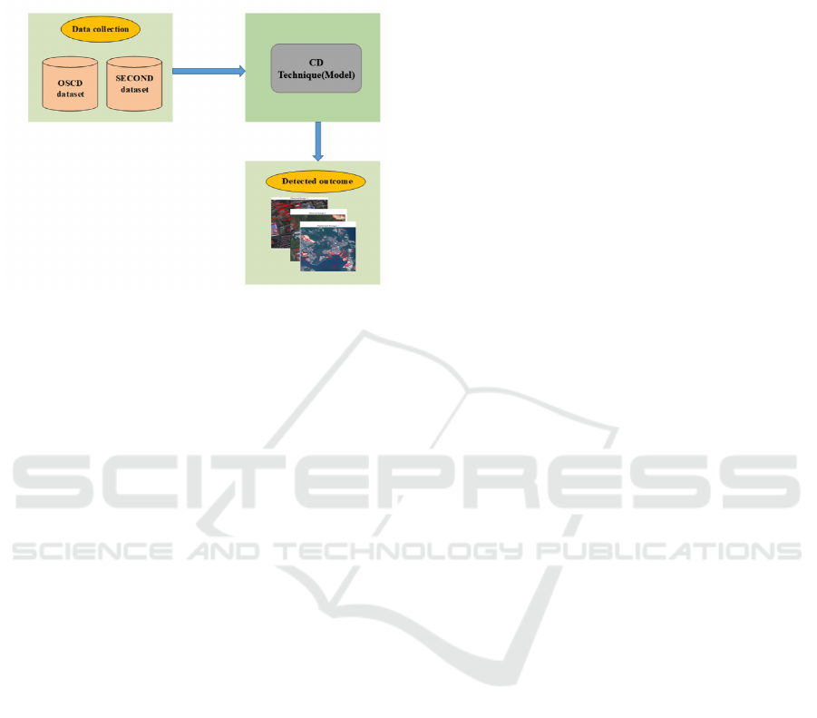
The dataset OSCD and SECOND are trained by each
considered technique, then trained model are tested
through test sample images.
Figure 1: Change Detection Process
4.1 Data Source
The dataset is derived from two separate sources:
the Onera Satellite Change Detection dataset (OSCD)
and the SEmantic Change DetectiON Dataset (SEC-
OND). OSCD is composed of multispectral images
obtained from Sentinel-2 satellites. This dataset is
utilized to tackle the challenge of identifying changes
between satellite images. The SECOND dataset em-
phasizes the identification of changes in land cover
and the accurate categorization of these changes with
precise pixel-level delineations. The approach iden-
tifies semantic changes through the utilization of fea-
ture pairs obtained from modules with varied struc-
tures, which consider different spatial extents and
quantities of parameters. The images from this
dataset undergo processing to eliminate noise and cor-
rect errors during the initial pre-processing stage.
4.1.1 Onera Satellite Change Detection dataset
The dataset comprises 24 collections of images ac-
quired from Sentinel-2 satellites during the period
from 2015 to 2018. Locations are selected from var-
ious regions across the globe. Each site is provided
with pairs of Sentinel-2 satellite images captured in
13-band multispectral mode. The OSCD dataset con-
tains images with varying spatial resolutions of 10m,
20m, and 60m(Caye Daudt et al., 2019).
4.1.2 Semantic Change Detection Dataset
The dataset comprises 4662 pairs of images sourced
from multiple platforms. Each image is characterized
by a resolution of 512 x 512 and includes pixel-level
details. The second annotation is conducted by a spe-
cialized group focused on earth vision applications,
ensuring a high level of label accuracy(Yang et al.,
2020).
4.2 Data Preprocessing
Images undergo pre-processing to address pixel size,
resolution issues, and to eliminate unwanted noise
and errors. Enhance the overall clarity of the origi-
nal image. Through the analysis of neighboring pix-
els and their likeness, it executes adaptive filtering,
thereby improving the overall quality of the image.
The method successfully minimizes noise in images
while preserving their structural integrity.
5 CHANGE DETECTION
TECHNIQUES
5.1 EffCDNet
It is enhanced Convolution Neural Network (CNN)
with preserving the efficiency and precision of seg-
mentation within the network. An optimized archi-
tecture known as EffCDNet utilizes a siamese-based
pre-trained encoder pair attached with an Attention-
based UNet decoder,which performs semantic seg-
mentation. The network utilizes a pre-trained Effi-
cientNet architecture, incorporating shared weights to
enhance feature extraction capabilities. The UNet de-
coder utilizes attention mechanisms and adopts the
attention-gate layer just prior to the concatenation op-
eration. This acquires more distinct relevant features
to enhance the segmentation performance. The re-
construction of fine-grained feature maps, leverag-
ing substantial context information for enhancement
in the change map, employed the Undecimated Dis-
crete Wavelet Transform (UDWT) fusion as a post-
processing technique. This approach facilitated spa-
tial and temporal analysis of multi-resolution images,
resulting in a significantly improved information dif-
ference map(Patil et al., 2021).
5.2 V-BANet
Deep learning techniques that employ V-Net and Bi-
lateral Attention Network (V-BANet) are utilized for
the segmentation of landscapes and the extraction of
features from images. The bi-temporal images are ini-
tially segmented using V-Net to independently iden-
tify the objects present in each image. The Bilateral
INCOFT 2025 - International Conference on Futuristic Technology
346
Attention Network employs spatial and channel atten-
tion blocks to enhance the extraction of discriminative
features from images. The relationships among the
features are elucidated through a comparison of the
original feature map in one image with the modified
feature map in another.(Prasad et al., 2023).
5.3 UCDNet
A deep learning model known as the urban CD net-
work (UCDNet) has been developed for urban change
detection using bi-temporal multispectral Sentinel-2
satellite images. The architecture of the model is
founded on an encoder–decoder framework that in-
corporates modified residual connections along with
the new spatial pyramid pooling (NSPP) block. The
encoder unit consists of two streams that have iden-
tical structures and share weights, as demonstrated in
Every input image is assigned to one of these identi-
cal structures. Similar to the FC-Siamconc network,
the encoder component is made up of convolutional
and pooling layers. Each stream incorporates three
pooling layers. The primary goals of the CD tech-
niques involve detecting variations between two im-
ages, with the disparity in the learned features serv-
ing as the input for the adjusted residual connection
at each stage of the encoder component.The input to
the NSPP block consists of features that have been
learned from the encoder section. This process aids
in extracting features across different ranges, provid-
ing insight into the global context(Basavaraju et al.,
2022).
5.4 RSCDNet
The RSCDNet-integrated Modified Self Attention
(MSA) module and Gated Linear Atrous Spatial Pyra-
mid Pooling (GL-ASPP) block’s extensive functional-
ity. In order to remove unnecessary channel informa-
tion from features at many scales, a GL-ASPP assem-
bly uses a channel-wise descriptor in conjunction with
a gated module. In order to successfully filter out ab-
normal information flow from the encoder to the de-
coder, the GL-ASPP block also accounts for channel
dependencies. Careful design went into the Modified
Self Attention (MSA) block so it could combine the
strengths of the channel attention operation with the
backbone self-attention unit. The input feature vec-
tor’s spatial channel dependency is used by this op-
erator. In contrast to the conventional self-attention
module, the computed channel-self attention is passed
via an attention gate to filter out extraneous data and
emphasize the important parts.(Barkur et al., 2022).
5.5 IU-Net
This approach employed an enhanced IU-Net con-
volutional network for the purpose of change detec-
tion. The IU-Net architecture consists of two distinct
pathways. The initial pathway, referred to as the en-
coder, is responsible for identifying the background
of images, while the subsequent pathway, known as
the decoder, determines the precise location of fea-
tures through transposed convolution. It employs 64
3×3 double convolution kernels across five blocks, in-
corporating the ReLu activation function, batch nor-
malization layers, and four 2×2 Max Pooling opera-
tors during the encoding phase. During the decoding
stage, a transposed convolution with a stride of two,
along with concatenation and two convolution layers
utilizing a 3×3 kernel size, was employed to upsam-
ple the multiscale feature maps. Upon completion of
the decoding stage, a singular 1×1 convolution layer
featuring a Softmax activation function, along with
weighted binary cross-entropy, is employed for the
purpose of change detection. The change detection
was conducted initially using RGB bands and subse-
quently with both RGB and NIR bands. In the analy-
sis of the datasets, 67% of the data was allocated for
training purposes, while 33% was designated for test-
ing(Gomroki et al., 2022).
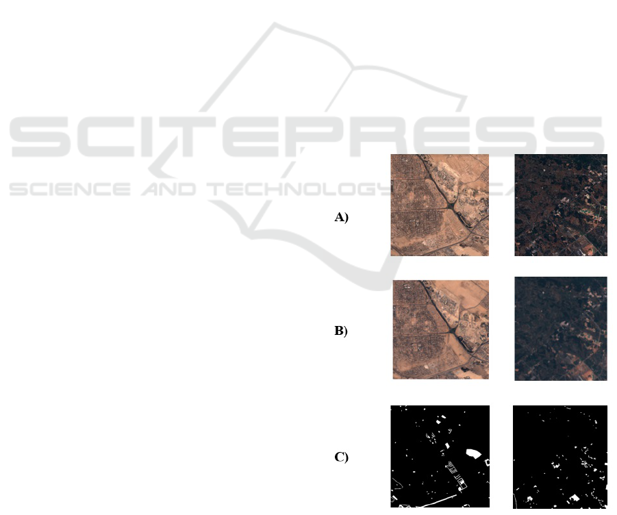
Figure 2: OSCD Dataset: A) Input Image B) Filtered Image
C) Detected Image
Comparative Examination of Different Change Detection Methods for Remote Sensing Imagery
347
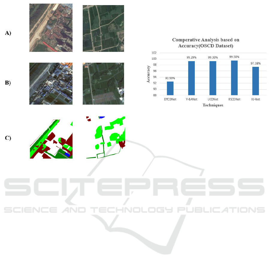
Figure 3: SECOND Dataset: A) Input Image B) Filtered
Image C) Detected Image
Samples of input images, preprocessed images
and change detected output images are shown for
OSCD data images and SECOND data images in Fig-
ure 2 and Figure 3 respectively
6 RESULTS AND DISCUSSION
6.1 Performance Analysis for OSCD
Dataset
Table 4 illustrates several performance metrics of
OSCD dataset. EffCDNet model achieved an accu-
racy of 92.6%, with corresponding precision, recall,
IoU and F1-score of 92.6%, 87.7%, 98% and 89.2%,
respectively. V-BANet transformer model demon-
strated high performance across all metrics, attaining
precision of 98.93% along with accuracy, IoU, recall
and F1-score of, 99.29%, 98.31%, 98.96%, 98.87%.
Similarly, UCDNet model showed recall at 86.16%,
with precision, accuracy, kappa co-efficient and F1-
score of 95.53%, 99.30%, 88.85% and 89.21%.
IU-Net model achieved F1-score of 98.65% along
with precision, recall, IoU and accuracy of 98.64%,
98.64%, 97.34% and 97.38%. RSCDNet achieved
an accuracy of 99.2% with recall, F1-score, IoU,
kappa co-efficient and precision of 99%, 99.1%, 96%,
98.10% and 99% respectively.
The performance analysis of various techniques is
shown in the graph figure 4 for OSCD. here compari-
son is shown for accuracy parameter.
Figure 4: Analysis on OSCD Data
6.2 Performance Analysis for SECOND
Dataset
Table 5 illustrates several performance metrics of
SECOND dataset. EffCDNet model achieved an ac-
curacy of 91.5%, with corresponding precision, re-
call, IoU and F1-score of 94.6%, 85.5%, 95% and
88.6%, respectively. V-BANet transformer model
demonstrated high performance across all metrics,
attaining precision of 96.83% along with accuracy,
IoU, recall and F1-score of, 97.29%, 96.31%, 97.6%,
98.5%. Similarly, UCDNet model showed recall at
85.25%, with precision, accuracy, kappa co-efficient
and F1-score of 96.5%, 98.78%, 87.8% and 89.30%.
IU-Net model achieved F1-score of 97.6% along with
precision, recall, IoU and accuracy of 97.4%, 98%,
97.5% and 96.80%. RSCDNet achieved an accu-
racy of 98.25% with recall, F1-score, IoU, kappa
co-efficient and precision of 98.50%, 98.7%, 97%,
98.30% and 98% respectively. The performance anal-
ysis of different techniques is shown in the Table 1.
The performance analysis of various techniques is
shown in the graph figure 5 for SECOND. here com-
parison is shown for accuracy parameter.
7 CONCLUSIONS
The discussion focuses on prevalent techniques for
detecting changes for satellite images and the ap-
proach of change detection following classification.
This paper proceeds from the principles of them, ana-
lyzing their results and comparing them with respect
to performance parameters such as accuracy, preci-
sion, recall, F1-Score, IoU (Intersection over Union),
INCOFT 2025 - International Conference on Futuristic Technology
348
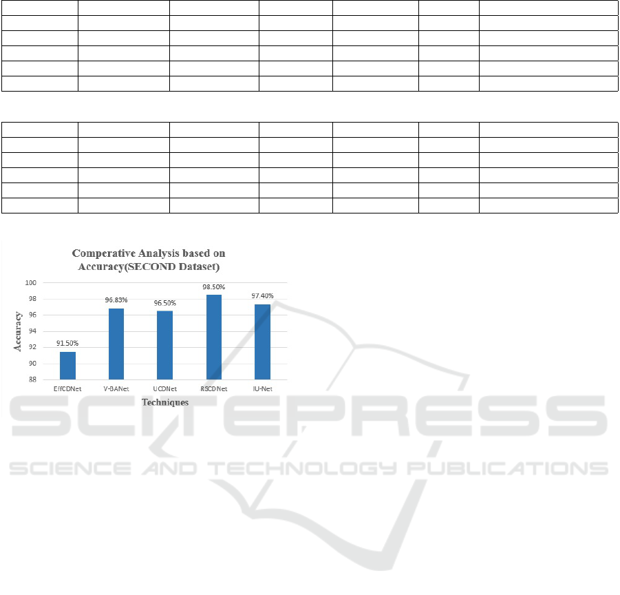
Table 1: Performance Analysis on OSCD Data
Techniques Accuracy (%) Precision (%) Recall (%) F1-score (%) IoU (%) Kappa co-efficient (%)
EffCDNet 92.5 92.6 87.7 89.2 98 -
V-BANet 99.29 98.93 98.95 98.87 98.31 -
UCDNet 99.30 95.53 86.16 89.21 - 88.85
RSCDNet 99.5 98.40 98.30 98.20 96 98.10
IU-Net 97.38 98.64 98.64 98.65 97.34 -
Table 2: Performance Analysis on SECOND Data
Techniques Accuracy (%) Precision (%) Recall (%) F1-score (%) IoU (%) Kappa co-efficient (%)
EffCDNet 91.5 94.6 85.5 88.6 95 -
V-BANet 96.83 97.29 96.31 97.6 98.5 -
UCDNet 96.5 98.78 87.8 89.30 - 88.85
RSCDNet 98.5 98.7 97 98.30 96 98
IU-Net 97.4 98 97.5 96.8 97.6 -
Figure 5: Analysis on SECOND Data
and Kappa. Two data sets are selected for experi-
mentation: OSCD and SECOND. The different CD
techniques proposed by various experts are imple-
mented and analyzed on the chosen dataset. Among
EffCDNet, V-BANet, UCDNet, RSCDNet, and IU-
Net, RSCDNet demonstrated superior performance,
achieving an accuracy rate of 99.5%.
REFERENCES
Alshehhi, R. and Marpu, P. R. (2023). Change detection
using multi-scale convolutional feature maps of bi-
temporal satellite high-resolution images. European
Journal of Remote Sensing, 56(1):2161419.
Bao, Q. and Guo, P. (2004). Comparative studies on sim-
ilarity measures for remote sensing image retrieval.
In 2004 IEEE International Conference on Systems,
Man and Cybernetics (IEEE Cat. No. 04CH37583),
volume 1, pages 1112–1116. IEEE.
Barkur, R., Suresh, D., Lal, S., Reddy, C. S., Diwakar, P.,
et al. (2022). Rscdnet: A robust deep learning ar-
chitecture for change detection from bi-temporal high
resolution remote sensing images. IEEE Transactions
on Emerging Topics in Computational Intelligence,
7(2):537–551.
Basavaraju, K., Sravya, N., Lal, S., Nalini, J., Reddy, C. S.,
and Dell’Acqua, F. (2022). Ucdnet: A deep learning
model for urban change detection from bi-temporal
multispectral sentinel-2 satellite images. IEEE Trans-
actions on Geoscience and Remote Sensing, 60:1–10.
Caye Daudt, R., Le Saux, B., Boulch, A., and Gousseau, Y.
(2019). Oscd - onera satellite change detection.
Chughtai, A. H., Abbasi, H., and Karas, I. R. (2021). A
review on change detection method and accuracy as-
sessment for land use land cover. Remote Sensing Ap-
plications: Society and Environment, 22:100482.
Fang, H., Du, P., and Wang, X. (2022). A novel unsu-
pervised binary change detection method for vhr op-
tical remote sensing imagery over urban areas. In-
ternational Journal of Applied Earth Observation and
Geoinformation, 108:102749.
Fatemi Nasrabadi, S. B. (2019). Questions of concern in
drawing up a remote sensing change detection plan.
Journal of the Indian Society of Remote Sensing,
47(9):1455–1469.
Gomroki, M., Hasanlou, M., and Reinartz, P. (2022). Iunet-
ucd: Improved u-net with weighted binary cross-
entropy loss function for urban change detection of
sentinel-2 satellite images.
Kondmann, L., Toker, A., Saha, S., Sch
¨
olkopf, B., Leal-
Taix
´
e, L., and Zhu, X. X. (2021). Spatial context
awareness for unsupervised change detection in opti-
cal satellite images. IEEE Transactions on Geoscience
and Remote Sensing, 60:1–15.
Patil, P. S., Holambe, R. S., and Waghmare, L. M. (2021).
Effcdnet: Transfer learning with deep attention net-
work for change detection in high spatial resolu-
tion satellite images. Digital Signal Processing,
118:103250.
Prasad, J., Sreelatha, M., and SuvarnaVani, K. (2023).
V-banet: Land cover change detection using effec-
tive deep learning technique. Ecological Informatics,
75:102019.
Qiu, L., Gao, L., Ding, Y., Li, Y., Lu, H., and Yu, W. (2013).
Change detection method using a new difference im-
age for remote sensing images. In 2013 IEEE Inter-
national Geoscience and Remote Sensing Symposium
- IGARSS, pages 4293–4296.
Comparative Examination of Different Change Detection Methods for Remote Sensing Imagery
349

Qu, Y., Li, J., Huang, X., and Wen, D. (2023). Td-sscd:
A novel network by fusing temporal and differential
information for self-supervised remote sensing image
change detection. IEEE Transactions on Geoscience
and Remote Sensing.
Raza, A., Huo, H., and Fang, T. (2022). Eunet-cd: Efficient
unet++ for change detection of very high-resolution
remote sensing images. IEEE Geoscience and Remote
Sensing Letters, 19:1–5.
Yan, L., Yang, J., and Wang, J. (2023). Domain knowledge-
guided self-supervised change detection for remote
sensing images. IEEE Journal of Selected Topics
in Applied Earth Observations and Remote Sensing,
16:4167–4179.
Yang, K., Xia, G.-S., Liu, Z., Du, B., Yang, W., Pelillo, M.,
and Zhang, L. (2020). Semantic change detection with
asymmetric siamese networks.
INCOFT 2025 - International Conference on Futuristic Technology
350
