
Advancing the Future of Integrated 5G-Satellite Networks: A Practical
Framework for Performance Evaluation, Dataset Generation, and
AI-Driven Approaches
Najmeh Alibabaie
a
, Antonello Calabr
`
o
b
, Pietro Cassar
`
a
c
,
Alberto Gotta
d
and Eda Marchetti
e
CNR-ISTI, Via Moruzzi 1, Pisa, Italy
Keywords:
Joint Simulation, Network Simulator, LEO Satellite Communications, Satellite-Terrestrial Integrated
Networks, Ray Tracing, Back-Hauling.
Abstract:
This paper introduces a framework for Satellite, Terrestrial Integrated Network (STIN), a modular and joint
simulation tool for simulating and evaluating integrated terrestrial and non-terrestrial communication systems.
The framework comprises various modules designed to model real-world environments, compute and analyze
constellation features, and perform channel modeling. Through the seamless integration of these components,
the STIN framework enables users to assess the performance of satellite constellations under diverse conditions
and select optimal configurations for enhanced coverage and communication efficiency. The paper discusses
the methodology and workflow of the framework and a preliminary implementation, suggesting avenues for
obtaining communication datasets to support AI-driven approaches.
1 INTRODUCTION
Combining 5G and satellite networks is important for
future global communication systems. In situations
where regular networks don’t work well or are hard
to use, this combination becomes crucial. Some ex-
amples are during disasters, in remote places, or in
areas like the ocean or air where normal networks
can’t reach. User groups like rescue teams, mobile
users, and critical infrastructure operators need reli-
able communication systems in these situations.
In response to these challenges, Satellite-
Terrestrial Integrated Networks (STINs) presents a
promising solution by merging the high capacity and
low latency of terrestrial 5G with the wide coverage
and resilience of satellite networks, particularly those
utilizing Low Earth Orbit (LEO) mega-constellations.
In hybrid architectures, satellites provide remote cov-
erage and act as a backup plan to ensure continuous
telecommunication services for critical applications.
a
https://orcid.org/0009-0002-8281-9767
b
https://orcid.org/0000-0001-5502-303X
c
https://orcid.org/0000-0002-3704-4133
d
https://orcid.org/0000-0002-8134-7844
e
https://orcid.org/0000-0003-4223-8036
However, the integration of terrestrial and non-
terrestrial networks (NTN) poses significant technical
challenges, such as high propagation delays in satel-
lite links, on-and-off connection due to satellite mo-
bility, the need for seamless handover management
between terrestrial and satellite systems, and interfer-
ence mitigation in shared frequency bands. Addition-
ally, protocol adaptation across different layers, from
the physical layer to the core network, is necessary to
maintain reliable end-to-end performance within the
hybrid network.
Indeed, the complexity of the multidimensional
aspects that must be considered in the real-world ex-
perimentation of STINs encourages the development
of simulation approaches and environments to design
and analyze STIN performance and quality. Accurate
simulation environments allow researchers to assess
whether the designed non-terrestrial network meets
specific application requirements across multiple lay-
ers, including the physical, network, and application
layers. However, existing simulation tools often do
not fully address the challenges posed by STINs or
lack comprehensive end-to-end analysis capabilities.
Some are also not well-suited to interact with various
existing simulation platforms.
312
Alibabaie, N., Calabrò, A., Cassarà, P., Gotta, A., Marchetti and E.
Advancing the Future of Integrated 5G-Satellite Networks: A Practical Framework for Performance Evaluation, Dataset Generation, and AI-Driven Approaches.
DOI: 10.5220/0013564400003970
In Proceedings of the 15th International Conference on Simulation and Modeling Methodologies, Technologies and Applications (SIMULTECH 2025), pages 312-319
ISBN: 978-989-758-759-7; ISSN: 2184-2841
Copyright © 2025 by Paper published under CC license (CC BY-NC-ND 4.0)

Recent real-world projects, including SpaceX
Starlink’s
1
experiments for 5G backhaul, AST Space-
Mobile’s
2
direct-to-device satellite service trials, and
OneWeb’s
3
collaborations with mobile operators for
hybrid 5G satellite connectivity, emphasize the grow-
ing demand for simulation-based performance eval-
uation tools. Furthermore, the 3GPP Release 17
guidelines for NTN integration provide a standardized
baseline that this proposed simulation framework can
utilize to ensure relevance for future system designs.
This paper aims to fill this gap by presenting
a simulation-driven evaluation framework for inte-
grated 5G-satellite networks, incorporating cross-
layer modeling and multi-tool integration. By focus-
ing on key performance indicators (KPIs) such as end-
to-end latency, throughput, handover success rates,
and efficiency in mobility management, the proposed
framework seeks to provide both new insights into the
feasibility and optimization of future STIN deploy-
ments and useful datasets.
Therefore, our fist objective is to simulate a STIN
network, focusing on the methodology and a prelim-
inary implementation of integrating tools that, while
not fully capable on their own, can be combined to
effectively simulate and analyze real-world scenarios.
Although the tools used in our initial implementation
are commercial, the methodology remains valid when
replacing each tool with an open-source alternative
that offers similar capabilities. This flexibility allows
readers to adapt our approach to their needs and re-
sources.
The second objective of our methodology is to
provide datasets generated through our simulation
framework. These datasets can help researchers over-
come obstacles encountered in real-world environ-
ments, enabling the analysis and prediction of vari-
ous features through Artificial Intelligence (AI) and
Machine Learning (ML)-driven approaches. Recog-
nizing the current lack of comprehensive and high-
quality datasets in the field, our objective is to con-
tribute to the development of a framework that not
only facilitates the generation of valuable data for fu-
ture STIN research but also promotes the sharing of
these datasets among researchers. In the long term,
this may reduce reliance on proprietary tools, ulti-
mately fostering advancements in the field through
data-driven insights and collaborative research ef-
forts.
The remainder of this paper is organized as fol-
lows. In Section II, a brief review of the related work
on simulation tools applied in STIN research is pre-
1
https://satellitemap.space/
2
https://ast-science.com/
3
https://oneweb.net/
sented. In Section III, we delve into the methodology
of our proposed STIN simulation framework, detail-
ing its design, components, and capabilities that make
it well-suited for simulating STINs. In Section IV, we
provide a validation example of execution to show-
case the performance of our proposed framework in
a real-world scenario. In Section V, we conclude the
paper by summarizing our key findings and contribu-
tions and shedding light on the potential future work.
2 RELATED WORK
Nowadays, several advanced simulation tools have
been developed and utilized to evaluate the perfor-
mance of STINs. These simulators are broadly cat-
egorized based on several key factors. For instance,
some tools are specifically designed to support mega-
constellations, which consist of large groups of satel-
lites in low Earth orbit working collaboratively to en-
hance connectivity and coverage.
Additionally, these simulation tools vary in their
availability. Some are offered as commercial soft-
ware, often providing extensive support and spe-
cialized features for professional use, while others
are available for free, promoting accessibility for re-
searchers and developers. Furthermore, each simula-
tor comes with distinct applications and functionali-
ties, allowing users to adapt their analyses to specific
scenarios, whether for network optimization, perfor-
mance testing under varied conditions, or assessing
the impact of environmental factors on satellite con-
nectivity.
Without being exhaustive, this section provides an
overview of the tools commonly used to analyze satel-
lite constellations and terrestrial communication sys-
tems. More detail on existing solutions, their evalu-
ation, and comparison can be found in (Jiang et al.,
2023), (Yastrebova et al., 2021).
NS-2, NS-3: NS-2, an older discrete event simu-
lator, can simulate various network protocols across
wired and wireless networks, including satellite net-
works. However, it lacks a graphical user interface,
presenting challenges in usage. NS-3 addresses this
limitation with its user-friendly Python interfaces and
data analysis tools (Puttonen et al., 2021), (Sormunen
et al., ). As an improvement over NS-2, NS-3 offers
better modularity, extensibility, and more realistic and
accurate models for various network components.
Matlab: it offers comprehensive toolboxes, including
5G and Satellite Communications Toolboxes, making
it well-suited for physical layer and link-level simula-
tions in STINs. Its alignment with 3GPP Release 17
and ready-to-use NTN channel models ensures that
Advancing the Future of Integrated 5G-Satellite Networks: A Practical Framework for Performance Evaluation, Dataset Generation, and
AI-Driven Approaches
313

researchers can easily study waveform adaptation,
propagation effects, and initial performance evalua-
tion. The visualization capabilities and integration
with Simulink
4
further enhance multi-layer modeling
across physical, MAC, and network layers. However,
Matlab is a commercial tool and could be expensive
when a combination of multiple specialized toolboxes
is required. Scalability could be an issue in the case
of large-scale network-level simulations (e.g., thou-
sands of satellites and devices). Additionally, its built-
in support for higher-layer protocols (e.g., transport
and application) could require customization or ex-
ternal integration. Finally, its real-time performance
and hardware-in-the-loop capabilities are less ma-
ture compared to dedicated network simulators; there-
fore, for end-to-end, large-scale STIN performance
evaluation, a hybrid simulation approach combining
Mathlab with other event simulators is recommended
(Mannoni et al., 2022).
System Tool Kit (STK): STK is a powerful simu-
lation tool that facilitates the construction and anal-
ysis of satellite constellations, exploration of air and
spacecraft missions, and modeling of hybrid network
performance. It is particularly useful for simulating
physical layer performance metrics based on satellite
propagation models, path loss models, and antenna
and transceiver models. However, STK targets mainly
the system-level mission analysis rather than detailed
communication protocol simulation. Integration with
external tools like Matlab or ns-3 can be required for
simulating end-to-end communication stacks or data
link, transport, and application layers (Li et al., 2021).
Hypatia: Hypatia is a framework designed for simu-
lating and visualizing Low Earth Orbit (LEO) constel-
lations. It combines NS-3 and the Cesium 3D map-
ping library, enabling the simulation of satellite tra-
jectories, link utilization changes, and available band-
width changes over time (Kassing et al., 2020). A
notable limitation of Hypatia is its lack of flexibility
in constructing various scenarios and its constrained
visualization capabilities.
Space Networking Kit (SNK): SNK is a network-
ing platform tailored for LEO mega-constellations.
It allows users to easily construct complex scenarios
through configuration files and a single bash com-
mand, facilitating the evaluation and visualization
of communication processes (Wang et al., 2024).
While recent enhancements improve SNK’s capa-
bilities, they may increase complexity for inexperi-
enced users and demand additional computational re-
sources, potentially affecting simulation efficiency for
users with limited hardware.
Satellite Network Simulator 3 (SNS3): SNS3 is a
4
https://mathworks.com/products/simulink.html
modular and flexible satellite model built upon the
open-source Network Simulator 3 (NS-3). It incor-
porates DVB-S2 and DVB-RCS2 specifications for
forward and return links, respectively, making it a
scalable and adaptable open-source simulator for net-
working research and development (Puttonen et al.,
2015).
OS3 OMNET++: OS3 is an open-source satel-
lite simulator built on OMNET++, offering modular-
ity, extensibility, and adaptability for simulating di-
verse satellite constellations and applications (Valen-
tine and Parisis, 2021). Despite the clear documenta-
tion and tutorials available for OMNET++, the lack of
specific resources for OS3 might pose challenges for
users seeking guidance on on its unique features and
capabilities. This limited support may prevent users
from fully utilizing OS3’s potential for various simu-
lation scenarios.
QualNet: QualNet is commonly used for modeling,
simulating, and analyzing the performance of com-
munication networks, particularly in scenarios where
communication endpoints are constantly changing
their position relative to each other or fixed infrastruc-
ture (Jennings et al., 2010).
Gpredict: Gpredict is a Linux-based program
that provides real-time satellite tracking and orbit
prediction. It utilizes the SGP4/SDP4 propagation
algorithms and NORAD TLE to achieve this func-
tionality (Jennings et al., 2010). As a Linux-based
program, Gpredict might not be accessible to users
on other operating systems without additional setup
or virtualization.
As highlighted in this not exhaustive survey, ex-
isting simulation solutions are very heterogeneous in
the provided features and the target KPIs. Therefore,
in designing a unified platform for STINs servers, is-
sues should be considered, such as i) discrepancies
in programming languages, network structures, and
data formats across different tools; ii) using software
conceived for work either with satellite or terrestrial
networks independently; iii) integrating these diverse
networks by combining the strengths of multiple sim-
ulation platforms; iv) complements the existing solu-
tions with specialized capabilities to smoothly solve
communication and data format issues.
If some of these issues have already been suc-
cessfully targeted in specific scenarios, such as indoor
communications environments (Hussain et al., 2024),
research is still needed to define a platform that can
effectively analyze the communication and channel
characteristics in integrated satellite-terrestrial net-
works. Therefore, the target of the paper is to com-
bine the strengths of various simulation platforms to
SIMULTECH 2025 - 15th International Conference on Simulation and Modeling Methodologies, Technologies and Applications
314
overcome the complexities of integrating diverse net-
works and contribute to more comprehensive STIN
evaluations.
3 METHODOLOGY
In this section, we introduce the methodology used
for developing our simulation framework designed for
STINs. This framework integrates different tools to
offer a modular solution for simulating various satel-
lite constellations and communication scenarios. Fig-
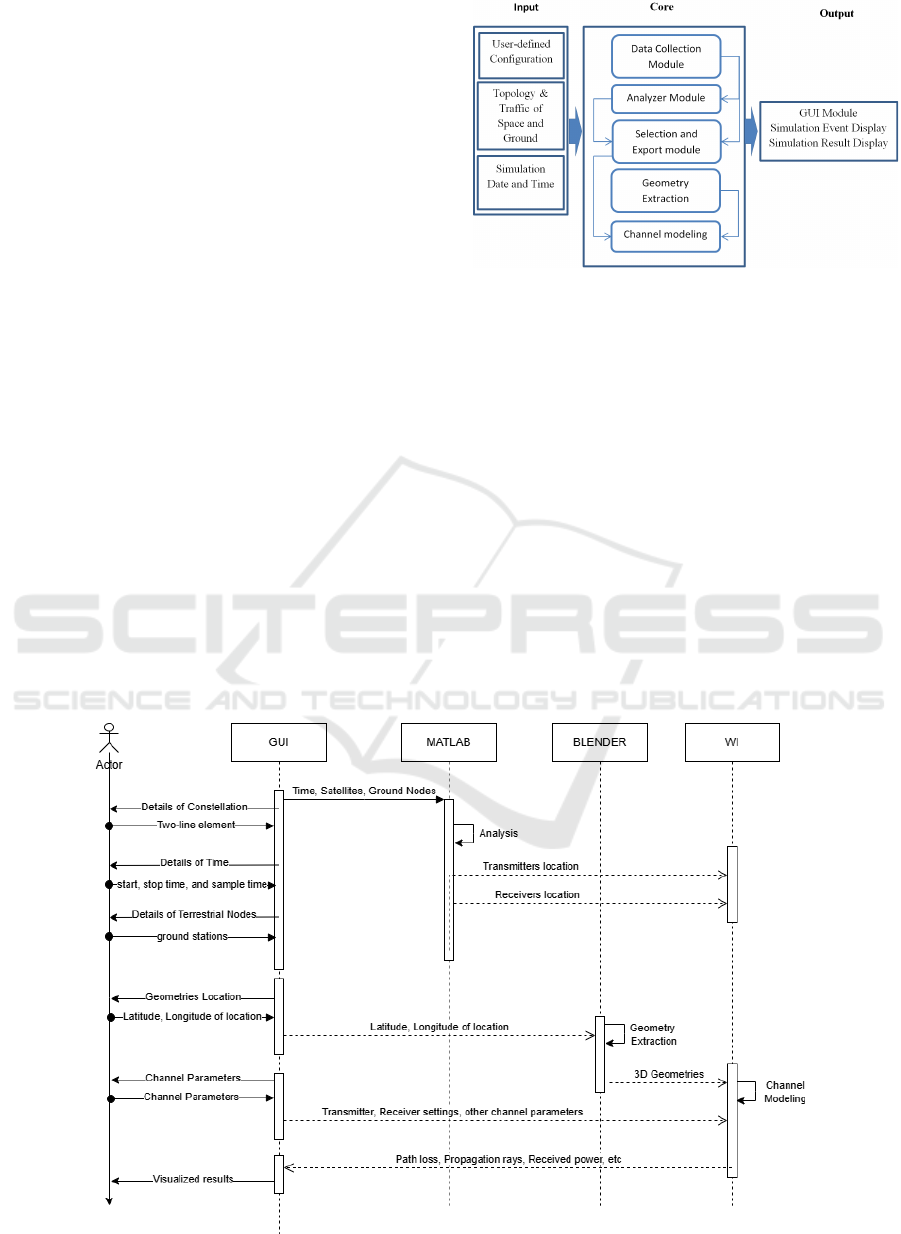
ure 2 depicts the STIN simulation framework. Our in-
tegrated STIN framework consists of three main com-
ponents, similar to those found in most software. The
input part involves feeding the framework with the
initial data necessary for analysis and obtaining re-
sults. This part is responsible for providing the simu-
lation with essential data and configurations, allowing
users to customize parameters and input the required
information for network representation. The core part
processes the input data, closely observing the con-
stellation to determine the distribution and movement
of satellites to create an accurate representation of the
real environment
Additionally, it generates a 3D version of the
ground that closely resembles the real environment.
Finally, it visualizes the communication between the
obtained constellation and the ground. The output
part of our framework presents the simulation events
Figure 2: The STIN simulation framework.
and results, offering users useful information to ex-
plore, understand, and assess the performance of
STIN under different scenarios and configurations.
To schematize the flow of data between different
tools in our framework, we provide a sequence dia-
gram (Figure 1) of the methodology execution using
three commercial tools (Matlab, Blender, and Wire-
less InSite (WI)). As mentioned in the introduction,
the selected tools were chosen due to their availabil-
ity within our institution. Alternative tools with simi-
lar performance can also be utilized.
In this case, the diagram illustrates the step-by-
step interactions between the main components of
our proposed STIN framework, highlighting how the
modules collaborate to simulate and analyze satellite
constellations in a realistic environment. The user-
Figure 1: Sequence Diagram of proposed STIN simulation.
Advancing the Future of Integrated 5G-Satellite Networks: A Practical Framework for Performance Evaluation, Dataset Generation, and
AI-Driven Approaches
315

provided inputs are transferred to different tools based
on their requirements. All data necessary for constel-
lation analysis and data related to the simulation un-
der investigation are transferred to MATLAB, where
the core processes related to that are executed. Any
data required for generating 3D models of the ground
environment is sent to and handled in Blender, which
performs the relevant processes. The data obtained
from these tools, along with other parameters, are
sent to Wireless InSite (WI) to compute the com-
munication performance between terrestrial and non-
terrestrial components. Finally, the simulation events
and results are sent back to the framework for visual-
ization and further analysis by the user. Considering
the Core component of Figure 2, in the following sec-
tions, details of each of its modules are provided.
3.1 Data Collection Module
This module simulates a satellite communication sce-
nario over time by iterating through several steps. As
shown in Algorithm 1, it first defines the scenario’s
details, including date/time, locations, and the satel-
lite constellation. Then, for each time step, it retrieves
the current location of the ground node and collects
a FeatureDataset containing the Date/Time, Azimuth,
Elevation, and Distance for the entire constellation.
The function repeats this process until the simulation
is complete and returns the collected FeatureDataset
for further analysis.
Algorithm 1. Collect-Data (TimeDetails).
1: Set Step ← 1
2:
3: while Step ≤ TotalTime / SampleTime do
4: Get the current location of Ground Node
5: Get the FeatureDataset for the entire constellation
(Date/Time, Azimuth, Elevation, Distance)
6: Increment Step
7: end while
8: return FeatureDataset
3.2 Analyser Module
The Analyzer module processes the collected features
from the scenario simulation and analyzes the satellite
constellation. Based on the Algorithm 2, in line 1, it
begins by calculating the Line-of-Sight (LOS) satel-
lites based on antenna orientation, which determines
which satellites are within the line of sight of the
ground nodes. Then in line 2, it computes the Mass
distribution function for LOS satellites’ Elevation,
Azimuth, and Distance to estimate the probability dis-
tribution of these parameters.
The function then determines the count of non-
line-of-sight locations in line 3 and calculates the
number of time intervals without visibility (line 4). In
line 5, it calculates the minimum and maximum satel-
lites in the line of sight for each point on the ground,
as well as the Access Interval - statistics of visibility
duration of LOS satellites, including the minimum,
maximum, and average values in line 6.
Based on line 7, the function identifies satellites
with comprehensive coverage, which helps locate
satellites that provide the most extensive coverage to
the ground nodes. Finally, it visualizes the analy-
sis to represent the findings of the satellite-ground
node communication, such as coverage, visibility, and
other essential characteristics (line 8). The function
concludes by returning the calculated satellite statis-
tics, providing valuable information for further anal-
ysis or decision-making.
Algorithm 2. Consellation-Analyzer (FeatureDataset).
1: SatStatistics (1) ← Calc-LOS ()
2: SatStatistics (2) ← Cal-Mass ()
3: SatStatistics (3) ← Comp-NLOS-count ()
4: SatStatistics (4) ← Calc-visibilityless ()
5: SatStatistics (5) ← Calc-LOS-Stat ()
6: SatStatistics (6) ← Calc-AcInterval-VisDuration ()
7: SatStatistics (7) ← Ident-Comp-Coverage ()
8: Visualize (SatStatistics)
9: Return SatStatistics
3.3 Selection and Export Module
The Selection and Export module performs satellite
selection and data export for simulation purposes. In
Algorithm 3,it takes the FeatureDataset and SatStatis-
tics, ground location as input. In line 1 it selects rep-
resentative satellites based on the analysis of the con-
stellation. In line 2, it calculates the ground projec-
tion of the selected satellites on the ground and finally,
it returns information about transmitter and receivers
for further use in simulations.
Algorithm 3. Selection-AND-Export ( Feature-Dataset,
Sat-Statistics, Ground-data).
1: [El, Az, Dis] ← Select-Representative ()
2: Satloc ← Calc-Projection (El, Az, Dis)
3: Return SatLoc
3.4 Geometry Extraction Module
As depicted in Figure 2, the Core component also in-
cludes modules managing the geometry and the chan-
nels. The Geometry Extraction module is a cru-
cial component for streamlining the CAD prepara-
tion process in simulating real-world environments
using Blender. It integrates the Blosm3 add-on, which
simplifies the creation of 3D CAD models for sim-
ulation purposes. Utilizing Blosm3’s functionality,
SIMULTECH 2025 - 15th International Conference on Simulation and Modeling Methodologies, Technologies and Applications
316
the module enables the following tasks: download-
ing real-world terrain data to ensure realistic simula-
tions; generating 3D CAD models of buildings from
the OpenStreetMap dataset; placing CAD models on
the terrain while considering various building height
and floor options; and importing forests and individ-
ual trees as 3D objects to enhance the simulation en-
vironment’s realism.
3.5 Channel modeling Module
This module focuses on modeling the interaction of
transmitted rays with surrounding geometries through
reflections, diffractions, and transmissions. Channel
models are incorporated to enable a realistic evalu-
ation of integrated terrestrial and non-terrestrial net-
work solutions’ performance.
Algorithm 4. Channel-Modeling ( Geometries, WaveDe-
tails, AntennaDetails, TransmittersLoc, ReceiversLoc).
1: Geo3D ← Import (Geometries (Train, City, Foliage))
2: SetMaterials (Geometries)
3: TransceiverWave ← DefineWave (WaveDetails)
4: TransceiverAnten ← DefineAntenna (AntennaDetails)
5: Trans ← EstablishTransmitter (TransceiverWave,
TransceiverAnten, TransmittersLoc)
6: Receiv ← EstablishReceiver (TransceiverWave,
TransceiverAnten, ReceiversLoc)
7: SetStudyArea (Geo3D, Trans, Receiv)
8: SetCommunicationSystem ()
9: RunSimulation ()
10: Return (Result)
The location of the transceivers has been imported
in line 1, and the geometric characteristics of the ge-
ometries’ material, waves, antennas, transmitters, and
receivers are defined in lines 2 to 6. Ray-tracing mod-
els have been employed in this module to simulate
the scenario, facilitating a detailed analysis of the
network’s performance within the given study area,
which is determined in lines 7 and 8. After running
the simulation (line 9) with the specified settings, the
module returns the results for further analysis.
4 VALIDATION OF EXECUTION
To validate our proposed framework, we applied it
in a simulation involving a real-world satellite con-
stellation and a defined terrestrial area, demonstrat-
ing its practicality and performance under realistic
conditions. Specifically, we used the TLE (Two-
Line Element) file of the Starlink constellation
5
and
set the simulation to begin at 18:30:00 local time on
5
https://celestrak.org/NORAD/elements/
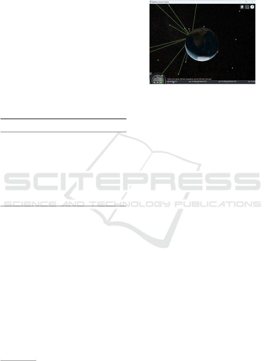
Figure 3: Access analyses between the satellites and the
ground station using Matlab.
2025/02/22, with a total duration of 20 minutes and
a sampling interval of 5 seconds. The terrestrial ob-
servation grid covered a rectangular area bounded by
latitudes 43.7061 to 43.7277 and longitudes 10.3834
to 10.4357, representing a set of ground nodes for vis-
ibility analysis.
During the constellation observation phase, the
framework monitored satellite movement and ground
coverage over time. This allowed the system to record
link availability and other spatial-temporal metrics
relevant for connectivity assessment. Figures 3 illus-
trates the simulated satellite constellation and ground
area setup. Figure 5 displays a portion of the dataset
collected after executing Module 1, and were then
passed to the next module for analysis.
Key features of the constellation were evaluated
using the analysis module. Figure 6 presents a sum-
mary of the analyzed features, which contributed to
the subsequent selection of an optimal set of con-
stellations with the most coverage in the simulation
area. Based on the extracted metrics, the simulation
recorded 197 unique satellites observed during the de-
fined time window. Each ground node maintained
LOS with between 11 and 25 satellites, and no re-
ceiver was left without visibility throughout the ob-
servation period.
Furthermore, the visibility duration per satellite
ranged from 5 to 150 seconds, offering insight into
temporal coverage dynamics. These results guided
the realistic selection of satellite subsets and their rel-
ative positions. With the analyzed features and other
inputs, the next component selected an optimal set
of constellations that provided the most comprehen-
sive coverage in the simulation area. Figure 7 show-
cases the selected satellites and their projected loca-
tions on the ground. To accurately reflect the physi-
cal environment in our simulation, we configured and
extracted the geometry of the target area bounded by
latitudes 43.7061 to 43.7277 and longitudes 10.3834
Advancing the Future of Integrated 5G-Satellite Networks: A Practical Framework for Performance Evaluation, Dataset Generation, and
AI-Driven Approaches
317
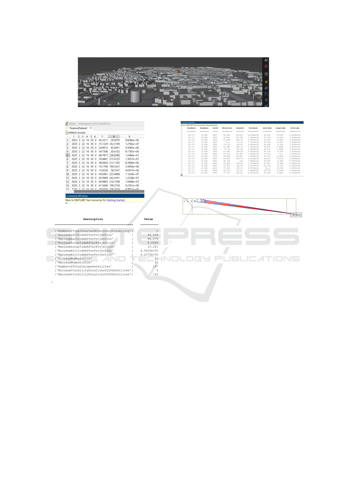
Figure 4: 3D CAD model of simulation area (Blender).
Figure 5: The output of Collect-Data module (Matlab).
Figure 6: The output of Consellation-Analyzer module
(Matlab).
to 10.4357 using Geometry Extraction Module. Fig-
ure 4 illustrates the resulting 3D representation of the
simulation environment.
After completing the constellation selection and
projection and geometry extraction, the data, consist-
ing of transmitter and receiver locations in a CSV file,
along with DAE files containing terrain, buildings, fo-
liage, and other objects, is fed into the channel mod-
eling module. Figure 8 depicts the channel modeling
process, which generated results that could be used
for further post-processing or AI-driven analysis.
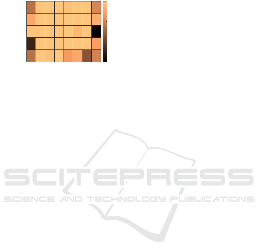
For each ground node, we compute a normal-
ized ray reception ratio, defined as the number of
rays received with power above the NB-IoT receiver
sensitivity threshold divided by the total number of
rays traced to that node. These results are shown in
Figure 9, where each cell corresponds to a specific
Figure 7: The output of Selection-AND-Export module
(Matlab).
Figure 8: Visualize several propagation Rays obtained in
the communication (WI).
ground location (defined by latitude and longitude)
and indicates the link reliability or ray coverage qual-
ity at that point. Higher values (close to 1) indicate
strong and consistent reception, while lower values
suggest potential outages or weak coverage areas due
to obstacles or poor link geometry. The generation
of these comprehensive datasets through our frame-
work paves the way for various data-driven applica-
tions in the field of STIN. These datasets can be used
to develop, train, and test ML and AI tasks such as
coverage prediction, outage detection, adaptive UAV
placement, or dynamic beam steering. Furthermore,
researchers use them to explore advanced applica-
tions, such as reinforcement learning for autonomous
network management and deep learning for enhanced
signal processing and interference mitigation.
5 CONCLUSION AND FUTURE
WORK
Our STIN framework presents a comprehensive and
modular approach for simulating and evaluating satel-
lite constellations in realistic environments. By in-
corporating various modules for observation, analy-
sis, and channel modeling, the framework offers valu-
SIMULTECH 2025 - 15th International Conference on Simulation and Modeling Methodologies, Technologies and Applications
318
10.3834
10.3909
10.3983
10.4058
10.4133
10.4208
10.4282
10.4357
Longitude
43.7061
43.7115
43.7169
43.7223
43.7277
Latitude
0.6257
0.8543
1
0.6163
0.9914
1
1
1
1
1
1
1
1
0.9657
1
1
1
1
1
0.9714
1
1
1
0.8
1
1
0.9371
1
0.8576
1
1
1
1
0.72
0.8971
0.8161
0.7018
0.2743
0.4919
0.1057
0.2
0.3
0.4
0.5
0.6
0.7
0.8
0.9
1
Figure 9: Normalized Link Quality per Ground Location in
the Simulation Area.
able insights into the performance and behavior of in-
tegrated terrestrial and non-terrestrial communication
systems. In future work, we will focus on further
enhancing our STIN framework. Key areas of im-
provement include refining the efficiency of constel-
lation selection algorithms and integrating advanced
AI techniques for more in-depth data analysis. These
advancements will enable more accurate and efficient
simulation and evaluation of integrated 5G-satellite
networks. Additionally, we will prioritize the devel-
opment of an automated platform to facilitate seam-
less communication and information exchange be-
tween various simulation tools. This automation will
streamline the simulation process, making it more ac-
cessible and efficient for a broader range of users.
Furthermore, recognizing that reliance on commercial
tools may not be feasible for all researchers, we will
continue to explore alternative simulation tools and
platforms. Our goal is to create a framework com-
posed entirely of free and open-source tools, ensuring
that the proposed methodology can be implemented
and utilized by anyone, regardless of their access to
commercial software.
ACKNOWLEDGEMENTS
We thank Tarun Chawla and Remcom Inc for the
Wireless InSite X3D ray tracer numerical analysis.
This work is supported by RESTART (PE00000001)
under the PNRR of the Italian MUR program
NextGenerationEU.
REFERENCES
Hussain, S., Bacha, S. F., Cheema, A. A., Canberk, B.,
and Duong, T. Q. (2024). Geometrical features
based mmwave uav path loss prediction using ma-
chine learning for 5g and beyond. 5:5667–5679.
Jennings, E. H., Segui, J. S., and Woo, S. (2010). Ma-
chete: Environment for space networking evaluation.
In AIAA Int. Conf.on Space Operations, page 1–12.
Jiang, W., Zhan, Y., Xiao, X., and Sha, G. (2023). Network
simulators for satellite-terrestrial integrated networks:
A survey. 11(0):98269–98292.
Kassing, S., Bhattacherjee, D., Aguas, A. B., Saethre, J. E.,
and Singla, A. (2020). Exploring the internet from
space with hy patia. In Proc. of the ACM Int. Measure-
ment Conference, page 214–229. New York, USA.
Li, J., Hua, N., Zhao, C., Zhu, K., Li, Y., , and Zheng, X.
(2021). Design and implementation of open optical
satellite network emulation platform (oosn-ep) based
on distributed multi-node system. In Opto-Electronics
and Communications Conf., page 1–3. Hong Kong.
Mannoni, V., Berg, V., Cazalens, S., and Raveneau, P.
(2022). System level evaluation for nb-iot satellite
communications. In IEEE 95th Vehicular Technology
Conference, page 1–6. Helsinki, Finland.
Puttonen, J., Herman, B., Rantanen, S., Laakso, F., and
Kurjenniemi, J. (2015). Satellite network simulator
3. workshop on simulation for euro pean space pro-
grammes. In Workshop on Simulation for Eu Space
Programmes, page 26. Noordwijk, Netherlands.
Puttonen, J., Sormunen, L., Martikainen, H., Rantanen, S.,
and Kurjenniemi, J. (2021). A system simulator for
5g non-terrestrial network evaluations. In IEEE 22nd
Int. Symposium on a World of Wireless, Mobile and
Multimedia Networks, pages 292–297.
Sormunen, L., Huikko, T., R
¨
onty, V., Sepp
¨
anen, E.,
Rantanen, S., Laakso, F., and Puttonen, J. Simu-
lative comparison of dvb-s2x/rcs2 and 3gpp 5g nr
ntn technologies in a geostationary satellite scenario.
In 12th Adv. Satellite Multimedia Syst. Conf., page
arXiv:2502.13704.
Valentine, A. and Parisis, G. (2021). Developing and exper-
imenting with leo satellite constellations in omnet++.
Wang, X., Han, X., Yang, M., Han, S., and Li, W. (2024).
Space networking kit: A novel simulation platform for
emerging leo mega-constellations. In IEEE Int. Conf.
on Communications, pages 5590–5595. Denver, USA.
Yastrebova, A., Anttonen, A., Lasanen, M., M., Vehkaper
¨
a,
, and H
¨
oyhty
¨
a, M. (2021). Interoperable simulation
tools for satellite networks. In IEEE 22nd Interna-
tional Symposium on a World of Wireless, Mobile and
Multimedia Networks, pages 304–309.
Advancing the Future of Integrated 5G-Satellite Networks: A Practical Framework for Performance Evaluation, Dataset Generation, and
AI-Driven Approaches
319
