
Research on Autonomous Navigation Algorithm of UAV Based on
Visual SLAM
Kai Huang
1
, Jinming Zhang
1
, Wei Zhang
1
, Daoyang Xiong
1,*
, Weiwei Wang
2
and Senyu Song
1
1
Tianjin Richsoft Electric Power Information Technology Co., Ltd, Tianjin, 300000, China
2
State Grid Information & Telecommunication Co., Ltd,Beijing, 102200, China
Keywords: Visual SLAM, UAV Autonomous Navigation Algorithm, Drone, Autonomous Navigation.
Abstract: In this paper, the autonomous navigation algorithm of UAV based on visual SLAM is studied to improve the
accuracy of autonomous positioning of UAV in complex environments and improve its ability to construct
maps. To do this, it is necessary to use the installed camera and IMU unit to record images and IMU data in
real time. Then, the ORB method is used to extract and match the features, and the autonomous navigation
algorithm is used to expand the pose estimation, and the Bundle Adjustment is used to optimize it. The results
of this paper show that in the indoor environment, the final pose difference after closed-loop optimization has
been significantly reduced by 0.08 meters, and the map reconstruction accuracy has reached 0.03 meters. In
the outdoor environment, the final positioning error is also significantly reduced by 0.09 meters, and the map
reconstruction accuracy is 0.05 meters. After experiments, it can be seen that the SLAM-based autonomous
navigation algorithm in this study can show good adaptability and robustness in different environments. The
research in this paper will provide reliable theoretical and practical support for the further development of
UAV autonomous navigation technology.
1 INTRODUCTION
At present, drone technology has developed rapidly,
and its application fields are constantly expanding,
and it is applied to many fields such as military
reconnaissance and environmental monitoring (Li,
Zhang, et al. 2023). However, there are still many
problems in the autonomous navigation performance
of current UAV technology in complex and dynamic
environments, especially the problems of positioning
accuracy and environmental perception, which are
relatively serious. Visual SLAM is an effective
autonomous navigation technology (Li, Li, et al.
2024), which can use cameras to obtain high-
definition images and sequences, carry out real-time
positioning, and complete map construction tasks,
which has become an important method to assist the
autonomous navigation of UAVs. Based on this, this
paper will study the autonomous navigation
algorithm of UAV based on SLAM (Ma, Wang, et al.
2021). In this paper, the performance of the algorithm
is verified through specific research processes and
experiments. In this paper, experiments are used to
verify the results. In this paper, the ORB feature
extraction and matching method is used to carry out
feature point detection, and then the algorithm is used
to complete the pose estimation work, and the Bundle
Adjustment is used to optimize the pose (Ukaegbu,
Tartibu, et al. 2022), (Wang, Kooistra, et al. 2024).
At the same time, the loopback detection and closed-
loop optimization work were combined to improve
the positioning accuracy and map consistency of the
UAV. The results show that in the indoor
environment, the pose error is reduced from 0.10
meters to 0.02 meters, and the map reconstruction
accuracy reaches 0.03 meters. In the outdoor
environment, the positioning error finally reached
0.04 meters, which is a decrease from the original
0.15 meters, and the map construction accuracy also
reached 0.05 meters, which is a relatively good result.
It can be seen that this study has good practical
application value. In addition, this study has many
contributions, such as the study in this paper proves
that the UAV autonomous navigation algorithm
based on visual SLAM can show high adaptability
and robustness in different complex environments.
Moreover, the improved method in this paper mainly
combines IMU data and closed-loop optimization,
which can provide good theoretical and practical
support for the further improvement and subsequent
Huang, K., Zhang, J., Zhang, W., Xiong, D., Wang, W. and Song, S.
Research on Autonomous Navigation Algorithm of UAV Based on Visual SLAM.
DOI: 10.5220/0013537400004664
Paper published under CC license (CC BY-NC-ND 4.0)
In Proceedings of the 3rd International Conference on Futuristic Technology (INCOFT 2025) - Volume 1, pages 157-163
ISBN: 978-989-758-763-4
Proceedings Copyright © 2025 by SCITEPRESS – Science and Technology Publications, Lda.
157

optimization and development of UAV autonomous
navigation algorithms. In addition, the research in this
paper also provides a certain reference value for the
subsequent application of visual SLAM technology in
UAV autonomous navigation.
2 RELATED WORKS
The research in this paper needs a certain theoretical
basis and framework. According to this study, the
relevant projects in this paper include:
2.1 Theory and Framework of Visual
SLAM
Visual SLAM uses cameras to acquire detailed image
sequences and combine them with sensor data,
allowing drones to achieve effective positioning in
the context of the location and build detailed maps to
aid subsequent research. It mainly includes feature
extraction and feature matching, pose estimation,
map update module, etc. Common SLAM algorithms
include LSD.SLAM and ORB.SLAM (Xu, Chen, et
al. 2024). The combination of visual data and IMU
data can improve the positioning accuracy and
robustness of autonomous navigation of UAVs. It
uses the global information provided by visual data
and the short-term and accurate motion estimation
provided by IMU data to carry out its work. Visual
SLAM based on deep learning. Visual SLAM can be
based on deep learning technology to enhance key
aspects such as feature extraction and matching. Deep
learning can automatically learn environmental
features, thereby improving the generalization ability
of SLAM UAV autonomous navigation algorithms
(Youn, Ko, et al. 2021).
2.2 Multi-View and Multi-Modal
SLAM
Based on the integration of multiple cameras and
sensors (such as vision cameras), the robustness and
accuracy of vision SLAM can be improved. The
multi-perspective will also provide people with a
wide variety of environmental information. It is worth
noting that multimodal fusion also helps SLAM
overcome the limitations of a single sensor device.
Moreover, it will also help drones to improve their
navigation capabilities in complex environments
(Zeng, Yu, et al. 2023); Real-time and resource
optimization. The visual SLAM algorithm needs to be
implemented on an embedded system with limited
resources. It can be seen that its main research
directions need to include real-time and resource
optimization. At present, the research basically
focuses on the lightweight processing and efficient
implementation of the algorithm, such as the SLAM
algorithm based on sparse features. At present, the
above research results are conducive to the research
of this paper and provide a basis for the further
development of UAV autonomous navigation
algorithm based on visual SLAM.
3 RESEARCH METHODS
3.1 Data Acquisition and Preprocessing
In this study, data acquisition and pre-processing
were the initial steps. The process requires a number
of components, such as sensor configuration and
environment preparation, data logging, and pre-
processing. Select and configure cameras and IMUs
for SLAM-based UAV systems. Common cameras
are RGB, RGB. D。 IMUs are mainly used to provide
data on acceleration and angular velocity. It is
important to stably install these sensors on vision-
based SLAM-based drones. The most important thing
is to make sure they work in sync. To this end, these
sensors are calibrated to obtain similar focal lengths,
principal point offsets, and external parameters
similar to IMUs, so as to ensure a high degree of data
accuracy (Zhang, Xie, et al. 2023).
Choose an environment with sufficient feature
points to start data collection. For this purpose, you
can choose an indoor environment or an outdoor
environment, and ensure that the environment has
rich textures, geometric features, etc. For example,
there are walls or building features (Zhang, Zhong, et
al. 2024). Then, the flight path of the drone began to
be designed, ensuring that the entire environment
could be covered and a variety of perspectives could
be obtained. During the flight of the UAV, it is
necessary to ensure that it can record the complete
image sequence and IMU data obtained by the camera
in real time to ensure the stability and continuity of
the data. At the same time, the time synchronization
between the image data and the IMU data is ensured.
The preprocessing of the acquired image data and
IMU data is completed. Image pre-processing needs
to include denoising and grayscale, distortion
correction, and thus improve the quality of the image.
In addition, IMU data pre-processing involves
removing noise, drift, and proceeding with
subsequent steps based on the filter balance data. In
addition, the processed data should be directly
INCOFT 2025 - International Conference on Futuristic Technology
158

converted into a format that matches the input
requirements of the SLAM algorithm, and then stored
in the database and file system to facilitate the
development and testing of the algorithm in the
future.
3.2 Feature extraction and Matching
Feature point detection is the key in feature extraction
and matching. Its job is to extract points from the
image that have obvious local features. In general,
people are accustomed to using feature point
detection algorithms such as ORB, SLFT, or SUFR.
In this paper, ORB is mainly used. The process of
feature detection is as follows: (1) detection of FAST
corners. For this, FAST should be used to perform
corner detection, see Eq. (1).
pq
I
It−>
(1)
In Eq. (1),
p
I
is the gray value of the pixel
p
;
q
I
is
q
the grayscale value of the pixel;
t
is the
threshold.
(2) Filter feature points. For this reason, NMS
should be performed for the detected corners to
screen out strong features, as shown in Eq. (2).
NMS( , ) if ( ) ( ) ( )
I
pIpIqqNp=>∀∈
(2)
In Eq. (2),
NMS( , )
I
p
it is the strong feature
that is screened out;
()Np
is
p
the neighborhood of
the point.
Feature description is used to turn each generated
feature point into a unique descriptor, so as to serve
the subsequent matching work. In this algorithm, the
BRIEF descriptor is used to complete the rotation
invariance processing. See Eq. (3) for details.
BRIEF( ) if ( ) ( )
x
y
p
Ip d Ip d=+<+
(3)
In the formula
()
3
,
BRIEF( )
p
is the descriptor,
x
d
and
y
d
is the pair of points that describe the sub.
(4) Rotational invariance. Based on this
algorithm, the descriptor is also processed with
rotation invariance, so that it has high rotation
robustness. See Eq. (4) for details.
arctan
y
x
I
I
θ
=
(4
)
In Eq. (4),
θ
it is the result of the rotational
invariance treatment;
y
I
,
x
I
is the image gradient.
(5) Feature matching. Feature matching is the
comparison of feature descriptors to determine the
correspondence between different images [6]. A
common method is Brute.Force matching. The
Brute.Force match can be expressed by Eq. (5).
( , ) desc ( ) desc ( )
pq
i
dpq i i=−
(5
)
In Eq. (5),
(,)dpq
is
p
the
q
result of the
feature matching of and;
desc ( )
p
i
And
desc ( )
q
i
is
the
p
q
descriptor of the feature point and the two
feature points.
(6) Two-way matching and verification. To
improve the reliability of feature matching, two-way
matching and cross-validation should also be used.
Pose estimation is a key part of the UAV
autonomous navigation algorithm based on visual
SLAM in this study. It needs to calculate the specific
position and attitude of the drone in space from the
matched image feature points. Firstly, the algorithm
is used to estimate the initial pose of the UAV by
using the matched image feature point pairs. Then,
the 3D points in space and the corresponding 2D
image points are used to find the pose of the drone.
See Eq. (6) for details.
()
2
min ,
ii
R
ti R t
π
−+
pP
(6
)
In Eq. (6),
i
p
are the points of the 2D image;
i
P
are 3D points;
R
is a rotation matrix;
t
is a
translational vector;
π
is a projection function.
Third, perform pose optimization. The BA
method is used to optimize the initial estimation pose.
In this process, it is generally necessary to adjust the
camera pose at each angle of view at the same time,
and adjust their respective 3D point positions. Then,
point the image. The error of the projection point is
minimized to improve the accuracy of pose
estimation [7].
Research on Autonomous Navigation Algorithm of UAV Based on Visual SLAM
159
3.3 Build a Map
In the research of UAV autonomous navigation
algorithm based on visual SLAM, map construction
is an extremely critical step. It can comprehensively
integrate the feature information contained in the
environment into a single, complete map model, so as
to make the autonomous navigation of drones more
accurate. First, it uses the detected feature points
based on the initial pose estimation to build an
initialized sparse point cloud map [8]. When the
drone is constantly moving, the SLAM system will
detect and match new feature points. Whenever a new
perspective and feature point is obtained, the map is
updated to show that the environment has changed,
adding new feature points and adjusting the position
of existing feature points. If the drone has already
passed through the same location, the SLAM system
will turn on loopback detection to identify the area as
one that has already been visited. Generally speaking,
it will match the feature points, and when the loop is
detected, the UAV system will automatically do
closed-loop optimization, and adjust each feature
point and pose in the map based on the global
optimization. At the same time, the accumulated error
is eliminated to ensure the consistency and accuracy
of the map. In addition, the algorithm can also help
the drone to establish a deeper and more stereoscopic
visual density, so as to make the drone navigation
more refined. Moreover, in order to ensure the
efficient management of map data, the system will
also automatically store these map data and store it in
a specific file or database section, and at the same
time, compress and index according to different needs
to ensure the fast access and use of data.
4 RESULTS AND DISCUSSION
4.1 Experimental Content
The environment of the experiment. The environment
of this experiment is two environments with rich
feature points, one is indoor environment and the
other is outdoor environment, so as to test the
performance of the algorithm in different scenarios.
(The configuration of the experiment is to install a
high-definition RGB camera and IMU sensor on the
drone to ensure the synchronization of data
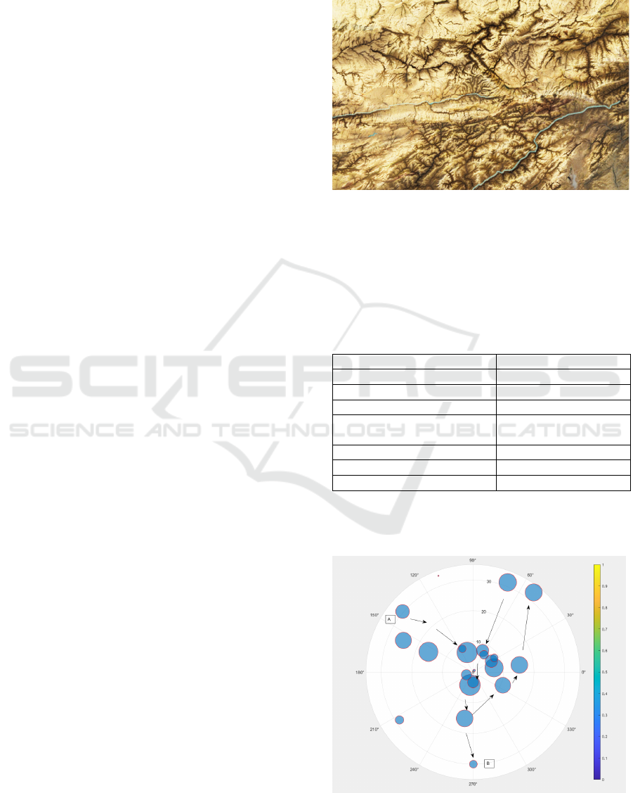
acquisition, and the test range is 12*36km, as shown
in Figure 1.)
Monday's analysis, however, in the analysis of the
test range, we can see that there are relatively many
obstacles in the entire test range, and the terrain is
relatively complex, and the overall situation is
relatively difficult, and the drone needs to calculate
the obstacles in order to realize the planning and
testing of the entire azimuth
Figure 1: UAV test range
4.2 Path Planning Results for
Autonomous Navigation
The results of this experiment are shown in Table 1,
Table 2 and Table 3.
Table 1: Indoor environment experimental results
Ite
m
Value
Path Len
g
th
(
m
)
50
Initial Pose Error
(
m
)
0.05
Final Pose Error (m) 0.02
Map Reconstruction
Accurac
y
(
m
)
0.03
Loo
p
Closure Detections 3
Pre.Loop Closure Error (m) 0.10
Post.Loop Closure Error (m) 0.02
The overall change in path planning is shown in
Figure 2.
Figure 2: Path change of the UAV
INCOFT 2025 - International Conference on Futuristic Technology
160
In the whole analysis process, its direction and
steering degree are generally good to achieve the
expected data analysis and reach the final goal In the
whole analysis process, the drone should adjust
according to the direction, direction and content to
achieve its own expectations and avoid external
influences and obstacles.
Figure 3: Navigation adjustment of the UAV
Through the direction of the UAV and its own
acceleration to achieve the expected point, and realize
the overall planning of the aircraft, realize the
adjustment of the entire direction, and the overall
change of the UAV and the comprehensive
orientation of the SLAM design, the analysis results
are relatively good, and the overall meets the
expected requirements.
4.3 SLAM Obstacle Avoidance Results
of UAVs
In the test map, the UAV performs path planning,
successfully bypasses the obstacle point, and
completes the video inspection of the range content,
as shown in Figure 4.
Figure 4: Autonomous navigation and inspection of uavs
It is found in Figure 4 that the UAV can realize
the obstacle avoidance and adjust the direction
according to its own posture to complete the
autonomous planning of the whole navigation In the
process of UAV testing and analysis, the integrity of
the navigation planning is relatively good, and finally
it can reach the expected closer point to realize the
overall test and distribution In the process of path
planning, the fault point avoidance should be carried
out, so the result of fault point avoidance is shown in
Table 2.
Table 2: Outdoor environment experimental results
Item Value
Path Length (m) 200
Initial Pose Error
(
m
)
0.08
Final Pose Error
(
m
)
0.05
Map Reconstruction
Accurac
y
(
m
)
0.05
Loo
p
Closure Detections 5
Pre.Loo
p
Closure Error
(
m
)
0.15
Post.Loop Closure Error (m) 0.04
However, there will be some errors in the evasion
process, and the errors should be analyzed, and the
results are shown in Table 3.
Table 3: Summary of experimental results
Enviro
nment
Ini
tial
Po
se
Err
or
(m
)
Fin
al
Pos
e
Err
or
(m)
Map
Recon
structi
on
Accur
acy
(m)
Loop
Clos
ure
Dete
ction
s
Pre.
Loo
p
Clos
ure
Erro
r
(m)
Post.
Loop
Clos
ure
Error
(m)
Indoor 0.0
5
0.0
2
0.03 3 0.10 0.02
Outdo
o
r
0.0
8
0.0
5
0.05 5 0.15 0.04
4.4 Overall Changes in Autonomous
Navigation
Several conclusions can be obtained through the
analysis, (1) the positioning accuracy is high. It can
be seen from Table 1, Table 2 and Table 3 that in the
two experimental environments, the final pose error
of the visual SLAM UAV autonomous navigation
algorithm adopted this time is significantly reduced
by 80% after closed-loop optimization, which proves
that closed-loop optimization can improve the
positioning accuracy. (2) Map reconstruction
accuracy. The algorithm can construct high-precision
maps in both indoor and outdoor environments, and
the reconstruction accuracy of the indoor
environment is 0.02 meters higher than that of the
outdoor environment, which may be due to the more
stable indoor feature points. (3) Loopback detection
and closed-loop optimization. Through experiments,
Research on Autonomous Navigation Algorithm of UAV Based on Visual SLAM
161

it can be seen that the loopback detection of the
algorithm can be successfully started in many
positions, and based on the closed-loop optimization
operation, the cumulative error can be significantly
reduced (reduced by 80%), and the consistency and
accuracy of the map can be improved. It can be seen
that the algorithm can have good autonomous
navigation performance of UAVs in different
environments, and can provide accurate positioning,
and the quality is also very high in map construction,
which can be applied to a variety of application
scenarios.
5 CONCLUSIONS
In this paper, a visual SLAM-based UAV
autonomous navigation algorithm is obtained, which
has superior performance in all aspects. From the
analysis of this paper, it can be seen that the
conclusions of the study are as follows:
First, high adaptability and robustness. From the
research in this paper, it can be seen that in the indoor
environment, after the closed-loop optimization of the
algorithm, the autonomous navigation experiment of
the UAV shows that in the indoor environment, the
final pose error is greatly reduced, and the map
reconstruction accuracy is 0.03 meters. In the outdoor
environment, the final positioning error has also been
significantly reduced, from the original 0.15 meters to
0.04 meters, and the map accuracy has reached 0.05
meters. It can be seen that the algorithm in this study
can show high adaptability and robustness in the
environment of different complex conditions. In
addition, the positioning accuracy and map
construction ability of the algorithm are very high.
Second, the algorithm can effectively eliminate
the accumulated error of UAV autonomous
navigation through loop detection and closed-loop
optimization. Through the experiments in this paper,
it can be seen that the loopback detection has been
successfully triggered 3 times in this laboratory test.
At the same time, it was successfully triggered 5
times in outdoor experiments. The success of each
loopback detection makes the map constructed by the
algorithm more consistent and accurate. This shows
that the UAV autonomous navigation algorithm
based on visual SLAM can effectively adjust the
navigation ability of repeated paths and ensure a
certain stability.
Thirdly, the algorithm can ensure the flight
stability and accurate navigation ability of the UAV
in different scenarios, and save labor costs. It can be
seen from the research in this paper that the
combination of IMU data, visual SLAM and UAV
technology can greatly improve the robustness and
real-time detection of the system in dynamic
environments, so as to ensure the flight quality of
UAV in complex scenes and improve its navigation
ability.
ACKNOWLEDGEMENT
State Grid Information and Communication Industry
Group Independent Investment Project , Research and
Application of Key Technologies for the Support
System of Large-Scale Promotion of UAV Based on
Integration Technology(546810230006).
REFERENCES
Li, D. D., Zhang, F. B., Feng, J. X., Wang, Z. J., Fan, J. H.,
Li, Y., et al. (2023). LD-SLAM: A Robust and Accurate
GNSS-Aided Multi-Map Method for Long-Distance
Visual SLAM. Remote Sensing, 15(18),22.
Li, Z. Y., Li, H. G., Liu, Y., Jin, L. Y., & Wang, C. Q.
(2024). Indoor fixed-point hovering control for UAVs
based on visual inertial SLAM. Robotic Intelligence
and Automation,2(3),22.
Ma, Y. F., Wang, S. X., Yu, D. L., & Zhu, K. H. (2021).
Robust visual-inertial odometry with point and line
features for blade inspection UAV. Industrial Robot-the
International Journal of Robotics Research and
Application, 48(2), 179-188.
Ukaegbu, U. F., Tartibu, L. K., Lim, C. W., & Amer Soc
Mechanical, E. (2022, Oct 30-Nov 03). SUPERVISED
AND UNSUPERVISED DEEP LEARNING
APPLICATIONS FOR VISUAL SLAM: A REVIEW.
Paper presented at the ASME International Mechanical
Engineering Congress and Exposition (IMECE),
Columbus, OH,2(3),32.
Wang, K. W., Kooistra, L., Pan, R. X., Wang, W. S., &
Valente, J. (2024). UAV-based simultaneous
localization and mapping in outdoor environments: A
systematic scoping review. Journal of Field Robotics,
41(5), 1617-1642.
Xu, J. Q., Chen, Z., Chen, J., Zhou, J. Y., & Du, X. F.
(2024). A precise localization algorithm for unmanned
aerial vehicles integrating visual-internal odometry and
cartographer. Journal of Measurements in Engineering,
12(2), 284-297.
Youn, W., Ko, H., Choi, H., Choi, I., Baek, J. H., & Myung,
H. (2021). Collision-free Autonomous Navigation of A
Small UAV Using Low-cost Sensors in GPS-denied
Environments. International Journal of Control
Automation and Systems, 19(2), 953-968.
Zeng, Q. X., Yu, H. N., Ji, X. F., Tao, X. D., & Hu, Y. X.
(2023). Fast and Robust Semidirect Monocular Visual-
INCOFT 2025 - International Conference on Futuristic Technology
162

Inertial Odometry for UAV. Ieee Sensors Journal,
23(20), 25254-25262.
Zhang, H. H., Xie, C., Toriya, H., Shishido, H., & Kitahara,
I. (2023). Vehicle Localization in a Completed City-
Scale 3D Scene Using Aerial Images and an On-Board
Stereo Camera. Remote Sensing, 15(15),23.
Zhuang, L. C., Zhong, X. R., Xu, L. J., Tian, C. B., & Yu,
W. S. (2024). Visual SLAM for Unmanned Aerial
Vehicles: Localization and Perception. Sensors,
24(10),92.
Research on Autonomous Navigation Algorithm of UAV Based on Visual SLAM
163
