
Identification and Prospecting Prediction of Marine Geological
Anomalies Based on Deep Learning
Jian Wang
1,2
,
Yongfeng Wang
1,2*
, Jianxin Zhang
3
, Guotao Pang
1.2
, Yinji Ba
1,2
and Guiheng Wang
1,2
1
Yantai Center of Coastal Zone Geological Survey, China Geological Survey, Yantai Shandong 264000, China
2
Ministry of Natural Resources Observation and Research Station of Land-Sea,
Interaction Field in the Yellow River Estuary, Yantai Shandong 264000, China
3
Northwest bureau of China Metallurgical Geology Bureau, Xian Shanxi 710119, China
Keywords: Deep Learning, Identification of Marine Geological Anomalies, Prospecting Prediction, Method.
Abstract: The need for deep-sea mineral exploration has become more urgent as marine resources become increasingly
scarce. In order to effectively identify marine geological anomalies and improve the accuracy of prospecting
prediction, this study proposes a multi-modal data fusion method based on deep learning to achieve anomaly
identification and prospecting prediction. Based on the fusion of multi-source data such as ocean seismic
waves, magnetism, gravity, etc., the method adopts adaptive feature extraction technology, and uses a double-
branch prediction network to perform anomaly identification and mineral enrichment prediction. Finally, the
results of this paper show that the system performs well in multi-regional seabed geological data, among
which the enrichment of copper ore is 3.5%, and the enrichment of nickel ore is 1.2%. The comprehensive
analysis shows that the model and its integrated platform have strong robustness in the complex marine
environment, which can effectively improve the efficiency of mineral exploration.
1 INTRODUCTION
The exploitation of marine mineral resources has
become a key component of the global economy, but
due to the complexity of the deep-sea environment,
traditional geological exploration methods have
many challenges in terms of cost and efficiency. In
order to solve the above problems, some researchers
have proposed that deep-sea geological anomalies
can be identified based on the joint analysis of
magnetic and gravity data (Chao, Wang, et al. 2023),
but this method cannot effectively deal with the
complexity of multimodal data. Some researchers
have also proposed that a simple machine learning
system based on seismic wave data can be used to
accomplish related tasks. However, due to the
ignorance of the importance of spatial features and
multimodal fusion, the results are not accurate
enough. In addition, some researchers have also tried
to estimate mineral enrichment based on geochemical
data analysis (De, Cocchi et al. 2024), but due to the
scarcity of sampling sites, it is not possible to predict
the full range of mineral distribution (Kim, Golynsky,
et al. 2022). In order to solve these limitations, this
paper uses deep learning algorithms and integrates
multi-modal data, and at the same time, based on
adaptive feature extraction and dual-branch network
prediction, in order to significantly improve the
accuracy of marine geological anomaly identification
and mineral prediction. This method can cope with
the complexity of marine data and provide new ideas
for future deep-sea mineral exploration. This chapter
analyzes the complexity of the deep-sea environment
based on the current situation of marine geological
resources development, studies the shortcomings of
various marine geological anomaly identification and
prospecting prediction algorithms, and puts forward
the development and application advantages of deep
learning in the current environment, and helps people
realize that it is of practical significance to apply deep
learning algorithms to marine geological anomaly
identification and prospecting prediction.
Wang, J., Wang, Y., Zhang, J., Pang, G., Ba, Y. and Wang, G.
Identification and Prospecting Prediction of Marine Geological Anomalies Based on Deep Learning.
DOI: 10.5220/0013535200004664
Paper published under CC license (CC BY-NC-ND 4.0)
In Proceedings of the 3rd International Conference on Futuristic Technology (INCOFT 2025) - Volume 1, pages 51-58
ISBN: 978-989-758-763-4
Proceedings Copyright © 2025 by SCITEPRESS – Science and Technology Publications, Lda.
51

2 RELATED WORKS
2.1 Deep Learning and Multimodal
Data Fusion will Better Reflect the
Characteristics of Marine
Geological Anomalies
When dealing with complex geological data, a single
data source generally cannot fully reflect the
characteristics of marine geological anomalies, so
multimodal data fusion technology is necessary
(Kochetov, Shepelev, et al. 2023). The theory of
multimodal data fusion is based on the use of
heterogeneous data from different sources, such as
seismic waves, magnetism, gravity, etc., based on a
unified framework (Kusnida, Albab, et al. 2023), to
perform processing, so that the model can extract
information from multiple dimensions and capture
the internal correlation between different modalities.
The attention mechanism and convolutional neural
network provided by deep learning will provide a
strong theoretical basis for this kind of fusion (Liu,
Wu, et al. 2023), which can automatically identify
the importance of each modal data and dynamically
adjust the weight of each data in the overall features.
This method can not only improve the efficiency of
data utilization, but also effectively enhance the
system's ability to identify anomalies (Ma, Chao, et
al. 2024), especially to adapt to the complexity of
marine geological data.
2.2 The Research Role of Adaptive
Feature Extraction and
Two-Branch Prediction in the Field
of Marine Geology
The theory of adaptive feature extraction refers to the
dynamic adjustment of the convolution kernel and
feature extraction process to adapt to the changes of
geological features in different regions (Ma, Liu, et
al. 2023), so as to facilitate the efficient extraction of
useful information in complex and changeable
environments. This is of great significance for the
spatial heterogeneity of marine geology, as the
geological structure of different seabed areas varies
significantly. At the same time, the two-branch
prediction theory combined with the idea of multi-
task learning (Sang, Long, et al. 2023) will complete
the task of identifying marine geological anomalies
and predicting mineral enrichment based on the
shared underlying characteristics. This approach can
effectively improve the efficiency of the model and
achieve the prediction of different goals under the
same framework, and it will also be optimized based
on the joint loss function, which will help the system
to have high accuracy and robustness when handling
complex tasks (Zhang, Liu, et al. 2023).
3 ABNORMAL MARINE
GEOLOGICAL STRUCTURES,
YOUR PRESET COMPARISON
FOR MINERAL EXPLORATION
3.1 Construction of a Comprehensive
Platform for Anomaly
Identification and Prospecting
Prediction Based on Deep Learning
A complete and integrated platform requires a
multifaceted composition. In this study, the
comprehensive platform has several functionally
important components, each of which is very
important and has its own function. In this process,
the data acquisition and preprocessing component is
a complex process that collects raw data from a
variety of ocean data sources and cleanses,
normalizes, and normalizes it. This component needs
to process a large amount of multi-modal data, such
as seismic waves, magnetics, gravity, geochemical
data, etc., and after processing, the data format can be
unified and high-quality to adapt to the input of deep
learning models. The multimodal data fusion
component needs to perform weighted fusion of
geological data from different sources based on the
attention mechanism, and further generate a unified
representation of marine geological features. Based
on the dynamic evaluation and fusion of the
importance of each modal data feature, the
component will effectively ensure that the model can
effectively apply the information of each data type, so
as to improve the accuracy of anomaly recognition.
The adaptive feature extraction component is
responsible for the use of adaptive convolution
networks to extract spatial features from marine
geological data. The component can dynamically
adjust the convolution kernel according to the
complexity of the marine geological environment to
capture geological changes at different scales. The
focus of this component is to accurately identify the
spatial location and morphology of anomalies, and to
provide key features for subsequent predictions. What
the Dual Branch Prediction Component does is to
perform geological anomaly identification and
mineral enrichment prediction at the same time. The
INCOFT 2025 - International Conference on Futuristic Technology
52

component is based on a two-branch architecture, one
of which ensures that the location and scope of the
anomaly can be controlled, and the other part ensures
that the mineral content and distribution of the
anomaly can be effectively assessed. These two
branches share the results of the underlying feature
extraction to ensure the collaborative execution of the
identification and prediction tasks. The system
training and evaluation component is designed to
manage the training process of the system and
continuously evaluate and adjust the performance of
the model. This component is based on techniques
such as backpropagation to effectively optimize the
parameters of the model, and uses the joint loss
function to perform multi-task training. In addition, it
needs to be responsible for ensuring the accuracy and
generalization ability of the validation set evaluation
system during the training process, and if necessary,
the component also needs to adjust the
hyperparameters to improve the prediction effect of
the system. The purpose of the adaptive optimization
component is to dynamically adjust the training
hyperparameters of the model, such as the
improvement rate, to ensure that the system can
converge stably in the complex marine environment.
According to the gradient change and the fluctuation
of the loss function, the component adaptively adjusts
the improvement rate to prevent the model from
falling into the local optimal solution and overfitting
phenomenon, so as to improve the overall robustness
and adaptability of the system.
3.2 Fusion of Multi-Source Data Such
as Marine Seismic Waves,
Magnetism, Gravity, etc., Adaptive
Feature Extraction, and Algorithm
Calculation
The process of identifying marine geological
anomalies involves a variety of geological and
physical data, such as seismic waves and magnetic
data, which reveal different aspects of the seabed
environment. Therefore, the model must be based on
multi-modal data fusion to jointly use the information
from these different data sources to obtain more
specific and comprehensive geological structure
characteristics. In this paper, we design an attention-
driven feature fusion method, which is mainly based
on the importance of weighted data of different
modalities to generate a comprehensive feature
representation, so as to facilitate more accurate
identification of the complex structure of anomalies.
See Eq. (1) for this.
m
ii
i
hh
fused
1=
=α
(1)
In this formula,
h
f
used
it is the integrated feature
representation after fusion, which mainly refers to the
overall characteristics of the final geological
environment obtained by the system when processing
multimodal data. It can ensure that the model will
consider the characteristics of different data sources
when making decisions, so as to enhance the
prediction ability of the system. ℎ
It refers to the
features extracted from different data modes, such as
the waveform features in seismic waves and the
intensity characteristics of magnetic anomalies. The
purpose of these features is to provide the model with
different perspectives of marine geological anomalies
and lay the groundwork for subsequent fusion.
𝛼
Represents weights, which are based on attention
mechanism learning and can dynamically allocate the
contribution of each data source based on the validity
of different modal data. For example, in a certain
region, if the magnetic data is more revealing about
the anomaly, then the model will automatically
increase the weight of the modality to enhance the
influence of the feature.
Marine geological data have significant spatial
heterogeneity, which means that the geological
characteristics of different regions may be
significantly different. In order to accurately capture
these differences, an adaptive convolutional kernel is
designed in the construction of the system, so that the
size and weight of the convolution kernel can be
flexibly adjusted according to the geological
complexity of different regions. This adaptive
convolution enables effective modeling of complex
geological structures, especially when capturing the
spatial distribution of marine anomalies. See Eq. (2)
for this.
K
ij k i k, j k
k
fW(x)
1
++
=
=
(2)
In this formula, it 𝑓
represents the output feature
after adaptive convolution, which refers to the
system's understanding of the anomaly at a certain
spatial location. This output will be used to determine
whether the area contains geological anomalies or
not. (𝑥
,
) Representing the input features, which
specifically refer to the geological data of adjacent
areas, based on capturing these neighborhood
features, the convolution operation will further assist
the model, allowing the model to understand the local
Identification and Prospecting Prediction of Marine Geological Anomalies Based on Deep Learning
53

geological environment more comprehensively.
𝑊
Represents the weight of the convolution kernel,
which can be dynamically adjusted according to the
geological characteristics of different regions. When
the geological information of a certain area has a large
change, then the convolution kernel will fully capture
the details of the anomaly based on weight
adjustment.
In addition to identifying the spatial location of
marine geological anomalies, it is also necessary to
assess the possible mineral enrichment within them.
To this end, the system adopts a double-branch
network structure to perform anomaly identification
and mineral enrichment prediction respectively. This
type of architecture allows the system to complete
both tasks in parallel based on a shared feature
representation to improve the overall efficiency and
prediction accuracy of the model. For this, see Eq. (3).
y f (h ), y f (h )
anomaly anomaly shared mineral mineral shared
==
(3)
In this formula, 𝑦
anomaly
it represents the output of
the anomaly identification branch, which is used to
predict whether there are geological anomalies in the
seabed area, and their specific location and
morphology. The main purpose of this branch is to
quickly locate anomalous objects. 𝑦
mineral
Represents
the output of the Mineral Enrichment Prediction
Branch, which is used to estimate the mineral content
of the anomaly. Based on this prediction, it can
provide a basis for subsequent prospecting decisions.
(ℎ
shared
) Represents a shared feature that is used to
support common feature extraction for both tasks. Its
function is to integrate the features extracted by
multi-modal data and spatial convolution to ensure
the synergy between anomaly identification and
mineral prediction.
3.3 Two-branch Prediction Network
Application
In this link, it is necessary to optimize the
identification of anomalies and the prediction of
mineral enrichment at the same time based on the
joint loss function. Based on multi-task learning, the
model can complete two tasks in continuous
reinforcement learning to improve the efficiency and
accuracy of the system. Depending on the needs of
the task, the system can adjust the weights during the
exercise to ensure that more attention is paid to a
particular task. For example, the value that can be
increased in scenarios where the anomaly
identification task is more important 𝜆
anomaly
.
In the optimization process of marine geological
anomaly identification and prospecting detection
model based on deep learning, it is necessary to
introduce geological prior knowledge to effectively
guide gradient update. This approach allows the
model to perform faster convergence in targeted
regions, especially in regions where anomalies are
known or present, and based on this, the accuracy of
the system can be realistically improved. Gradient
enhancement means that the gradient update
amplitude of a specific area should be increased when
the parameters are systematically updated based on
prior knowledge in the geological field. Based on this,
it will effectively ensure that the model receives more
attention in key geological anomaly areas and
captures potential geological anomalies more quickly.
The system then has to deal with the multi-scale
characteristics of marine geology, that is, the seabed
topography and geological structure in different
regions may span multiple scales. To this end, a
multi-scale regularization strategy is designed to
prevent the system from overfitting information of a
specific scale based on capturing local and global
geological features at the same time. For this, see Eq.
(4).
()
n
iij
ij
L
2
2
reg
1=
=λ θ + θ −θ
(4)
In this formula, 𝐿
reg
this is the regularized loss
term to help the model maintain stability and
accuracy. In the identification of marine geological
anomalies, the geological structure is complex and
diverse, so the model has to deal with different types
of anomalies, so if the system is too sensitive to some
specific data, it is likely to make its performance on
new data too poor. In this way, the excessive
fluctuations of system parameters can be effectively
reduced, and the model can be prevented from
"remembering" the characteristics of specific regions,
so as to enhance the generalization ability of the
model in different ocean regions and better identify
unknown geological anomalies.
λ
is the
regularization coefficient, which can control the
intensity of regularization. In the "prospecting
forecast", if the
λ
value is large, it means that the
integrated platform places more emphasis on the
stability of the system to prevent the system from
performing poorly in areas with large data
fluctuations, such as complex seabed geological
structures. However, if the value is too large, it means
that the model may ignore subtle geological changes,
such as the characteristics of small-scale mineral-rich
INCOFT 2025 - International Conference on Futuristic Technology
54

areas, so the integrated platform will adjust the value
according to the specific geological characteristics
λ
to make the model have a balanced performance in
different scenarios.
i
θ represents the first parameter
of the model
i
. For marine geological data, the
operating system parameters
i
refer to the ability of
the model to deal with specific geological features,
such as seismic wave characteristics and magnetic
anomalies in a certain area. The purpose of the
regularization term
i
2
θ
is to constrain the parameters
of the operating system and ensure that the
parameters are not too large, so that the model will
not rely too much on a certain data feature when
dealing with different geological structures, but can
judge the enrichment of minerals in the anomaly
according to a variety of characteristics. In this way,
the overfitting of the operating system to certain
extreme geological features will be avoided and its
adaptability will be enhanced.
∑
𝜃
−𝜃
It is used
to constrain the differences between different model
parameters, especially the correlation between
geological features in adjacent areas. In the marine
geological environment, the geological
characteristics of adjacent areas generally have some
spatial continuity, such as the thickness of
sedimentary layers and the distribution of faults,
which will not change drastically suddenly.
Therefore, the purpose of this project is to ensure that
the operating system can capture the continuity of
geological features when dealing with these areas,
that is, the model parameters will not fluctuate
drastically between adjacent areas. For example,
when an operating system predicts the mineral
enrichment of an area, if the geological conditions of
the area are similar to those of adjacent areas, the
differences in parameters should also be consistent,
which can help the model to more accurately identify
the distribution of potential mineral resources.
n
Represents the number of parameters, which refers to
the total number of parameters that must be optimized
on the entire marine geological dataset of the deep
learning system.
Because of the complexity and dynamic changes
of the marine environment, such as violent
fluctuations in seabed topography, ocean currents,
geological movements, etc., the deep learning model
needs to flexibly adjust the learning rate according to
the changes in data characteristics to ensure a stable
and efficient exercise process. The adaptive
improvement rate mechanism can enable the
operating system to balance the learning speed and
training stability in the face of these complex
situations, and at the same time, ensure that the model
will not affect the convergence of the operating
system due to unreasonable improvement rate setting
on the basis of accurately capturing geological
anomalies. See Eq. (5) for this.
𝛼
= 𝛼
⋅
1
1+𝛽|∇𝐿
|
(5)
In this formula, represents the
t
α
t
rate of
improvement at the first iteration, which controls the
pace at which the model updates parameters at each
step. Its function is to determine how quickly the
operating system responds to current errors. If the
improvement rate is too large, the deep learning
model may miss the optimal parameters. If it is too
small, the workout time of the operating system will
increase significantly.
t
L∇ Represents the gradient
of the current loss function, which is the size of the
model's current error on the input data. If the gradient
is large, it means that the characteristics learned by
the operating system at this stage are more complex,
so the improvement rate should be reduced to ensure
steady convergence. If the gradient is small, it means
that the model is already familiar with the current task
and can speed up learning.
β
is a moderating
parameter that controls the effect of the gradient on
the improvement rate.
β
The effect is to balance the
magnitude of the gradient change to the improvement
rate. If
β
the setting is larger, the improvement rate
will be more sensitive to changes, which will help the
model to respond more quickly in the face of complex
marine geological environments. If the setting is
small, it can prevent the operating system from being
overly sensitive to short-term gradient fluctuations to
avoid significant changes in the improvement rate
unnecessarily. Based on the adaptive improvement
rate adjustment strategy, the operation system can
adapt to the dynamically changing marine
environment, and gradually converge in the area with
complex geological structure and unstable
characteristics, so as to better identify anomalies and
improve the accuracy of prospecting prediction.
4 RESULTS AND DISCUSSION
4.1 Marine Geological Area Testing
In order to more efficiently identify marine geological
anomalies and predict the possible enrichment of
mineral resources in a deep-sea mineral exploration
Identification and Prospecting Prediction of Marine Geological Anomalies Based on Deep Learning
55
project, this study introduces this self-designed deep
learning integrated platform, hoping to effectively
cope with the limitations of traditional exploration
methods in complex seabed environments. The area
has a typical multi-layered geological structure, and
after many surveys, it has been found that the area
may contain abundant polymetallic nodules and
natural gas hydrates, which provides an important
strategic reserve potential for the development of
marine resources, the test area results are shown in
Table 1.
Table 1: Distribution of Multimodal Data by Region.
Region Seismic
Wave Data
Volume
(
GB
)
Magnetic
data volume
(GB)
Gravity
data
(GB)
Number of
geochemical
samples
A 120 30 25 500
B 150 40 30 600
C 100 20 15 300
Table I shows the distribution of the amount of
multimodal data collected in each region. Among
them, the seismic wave and magnetic data of area B
are large, reflecting its active geological movements.
This exploration mission covers three areas of sea
area A, B and C, and the geological characteristics of
each area are obviously different. Area A is located in
a sedimentary basin and is mainly composed of fine-
grained sediments; Zone B is an area with a
significant history of volcanic activity with active
fault zones; Area C is located in a deep-sea basin and
initial exploration indicates possible enrichment of
gas hydrates, the structure of the testing area is shown
in Figure 1.
Figure 1: Model construction of marine geological
anomalies.
This exploration mission covers three areas of sea
area A, B and C, and the geological characteristics of
each area are obviously different. Area A is located in
a sedimentary basin and is mainly composed of fine-
grained sediments, with 120 GB of seismic wave data
and 500 geochemical samples. Region B is an area of
significant volcanic activity, with 150 GB of seismic
wave data and 600 geochemical samples. In order to
perform more accurate anomaly identification and
mineral prediction, the design of a comprehensive
platform in this study integrates multi-modal data
fusion, adaptive feature extraction, and dual-branch
prediction network.
4.2 Abnormal Ocean Address, Testing
the Mining Area
Based on the automatic extraction and fusion of key
features from multi-modal data such as seismic
waves, magnetism, and gravity, the integrated
platform can accurately identify the spatial
distribution of geological anomalies and predict the
mineral enrichment in them, the test results are shown
in Table 2.
Table 2: Feature extraction results after data
processing.
Regio
n
Seismic
Wave
Extractio
n
Features
(
Wei
g
hts
)
Magnetic
Characteristics
(Weights)
Gravity
Feature
(Weights)
Geochemical
characteristics
(weights)
A 0.45 0.30 0.15 0.10
B 0.50 0.35 0.10 0.05
C 0.40 0.25 0.20 0.15
Table 2 shows the features extracted from the
different modal data and their importance weights. It
can be seen that seismic waves and magnetic
characteristics dominate the identification of
anomalies, Determine the range of regional structure,
as shown in Figure 2.
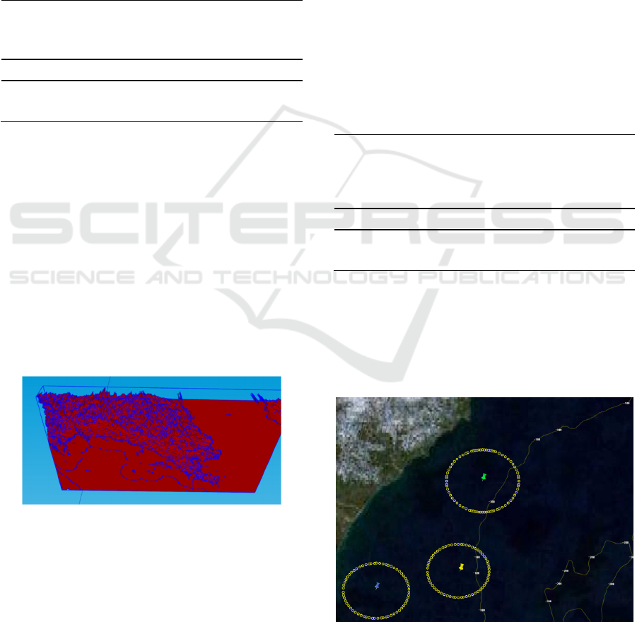
Figure 2: Identification of marine geological anomalies.
INCOFT 2025 - International Conference on Futuristic Technology
56

From the data analysis in Figure 2, it can be found
that there are certain anomalous points in the process
of determining the range of anomalous structures in
the ocean. Mainly distributed in the left and right
parts of the graph.
4.3 Abnormal Ocean Address, Test
Results for Predicting Mining
Areas
Based on the research and analysis of the above three
table data, it can be seen that the seismic wave
reflection layer in region B has obvious anomalies,
corresponding to the traces of volcanic activity in this
area. In the magnetic data, the magnetic anomalies in
this area are strong and show potential mineralisation.
In contrast, the seismic wave reflection in region C is
relatively uniform, but the local anomalies in the
magnetic data indicate that it may have a small-scale
gas hydrate enrichment zone. Combined with these
features, the integrated platform successfully
identified anomalies in the volcanic region and
speculated on their possible mineral distribution. The
identification areas of different outlier points are
shown in Table 3.
Table 3: Predictions of mineral enrichment by region.
Region Copper
Ore
Enrichmen
t
Forecast
(
%
)
Nickel Ore
Enrichment
Forecast (%)
Gas Hydrate
Enrichment
Forecast (%)
region
A 2.5 1.5 0.8 A
B 3.8 2.0 0.5 B
C 1.2 0.9 4.5 C
Table 3 shows the projections of mineral enrichment
in each region from the integrated platform. Zone B
is prominent in copper forecasts, while Zone C shows
high enrichment in gas hydrates. In the gravity data
of regions A and B, it can be observed that the gravity
anomalies in region A are relatively uniform, while
the gravity anomalies in region B are obvious, which
indicates that the area has a dense rock structure,
which is consistent with the enrichment of copper and
nickel elements in its geochemical data. Geochemical
data indicate that area B has a high content of copper
and nickel ore, which confirms the impact of volcanic
activity on mineral enrichment. In the mineral
enrichment prediction, the copper enrichment in Zone
B is 3.8%, which is much higher than that of other
regions, indicating that this area is a key area for
future exploration. In contrast, Region C has the
highest gas hydrate enrichment of 4.5%, indicating
that this region has some potential for energy
development. Based on the above analysis, the
comprehensive platform designed in this study can
effectively combine multi-modal data to accurately
predict mineral enrichment in complex geological
environment, and provide a reliable basis for actual
exploration.
5 CONCLUSIONS
Based on the designed integrated platform for the
identification and prospecting prediction of marine
geological anomalies based on deep learning, this
paper successfully realizes the efficient identification
and mineral enrichment prediction of marine
geological anomalies. Based on the integration of
multi-source geological data, the integrated platform
significantly improves the accuracy of anomaly
identification in complex seabed environments, and
shows strong prospecting and prediction capabilities
in different regions. In short, the comprehensive
performance of this comprehensive platform can
provide important technical support for future marine
resource exploration, and at the same time, it can also
provide a strong and scientific basis for the
development of marine minerals. This study is fully
reliable, but it has some limitations in terms of data,
and it can be expanded in the future. There are
limitations in this study, mainly the deep learning
dataset and the incomplete collection of marine
geological anomaly identification and selection,
which will be analyzed in the future.
ACKNOWLEDGEMENTS
China Geological Survey, Investigation, Monitoring
and Evaluation of Water Sediment Interaction and
Ecological Environment Carrying Capacity in the
Middle and Lower Reaches of the Yellow River
Basin (Henan Section, DD20220885.
REFERENCES
Chao, N.F., Wang, S., Ouyang, G.C., Hwang, C., Jin, T.Y.,
Zhu, C.C., Abulaitijiang, A., Zhang, S.J., Yue, L.Z.,
Chen, G., Zhang, Y.Z. (2023). An improved triple
collocation-based integration of multiple gravity
anomaly grids from satellite altimetry: Contribution of
ICESat-2. Remote Sensing of Environment, 292.
Identification and Prospecting Prediction of Marine Geological Anomalies Based on Deep Learning
57

De Ritis, R., Cocchi, L., Passaro, S., Chiappini, M. (2024).
Giant landslide, hidden caldera structure, magnetic
anomalies and tectonics in southern Tyrrhenian Sea
(Italy). Geomorphology, 466.
Kim, H.R., Golynsky, A.V., Golynsky, D.A., Yu, H., von
Frese, R.R.B., Hong, J.K. (2022). New Magnetic
Anomaly Constraints on the Antarctic Crust. Journal of
Geophysical Research-Solid Earth, 127(3).
Kochetov, M.V., Shepelev, A.A., Chelyshev, S.V. (2023).
The Possibilities of On-Board Gravimetric and
Hydromagnetic Surveys in Solving Engineering-
Geological Problems on the Shelf. Moscow University
Geology Bulletin, 78(4), 531-540.
Kusnida, D., Albab, A., Nainggolan, T.B., Firdaus, Y.
(2023). The Occurrence of Recent-Subrecent Seabed
Acoustic Anomalies and Its Relationship with
Structural Uplift around the Waipoga Trough, West
Papua-Indonesia. Indonesian Journal of Geoscience,
10(1), 109-117.
Liu, Y.T., Wu, Y.Q., Yang, L., Zhou, P.Z., Kuang, J.X., Yu,
W.J., Wang, J.Q., Xu, Z., Li, G. (2023). A Multi-Task
Learning for Submarine Cable Magnetic Anomaly
Recognition. Journal of Marine Science and
Engineering, 11(5).
Ma, A.Y., Chao, N.F., Qin, P.B., Hwang, C., Zhu, C.C.,
Chen, G., Wang, Z.T., Wang, S. (2024). Performance
assessment of sentinel-3/6 altimeter data for marine
gravity recovery. Frontiers in Marine Science, 11.
Ma, L., Liu, C.G., Yang, A., Liu, B.H., Xia, C.L. (2023).
Characteristics of gravity anomalies and tectonic
analysis of Enderby Land in East Antarctica and its
adjacent areas. Acta Oceanologica Sinica, 42(2), 94-
103.
Sang, N.V., Long, K.V., Dung, T.T., Nguyen, L.V., Que,
B.C., Mong, D., Quang, B.D., Andersen, O.B.,
Forsberg, R., Bui, D.T. (2023). Seafloor depth mapping
of central Vietnam's sea area and its surrounding using
gravity anomaly data and gravity geological method.
Advances in Space Research, 72(5), 1721-1738.
Zhang, W., Liu, W.H., Wang, X.F., Huang, Z.L., Kong,
Q.F., Luo, H.Y., Zhang, D.D., Liu, P., Chen, X.Y., Cai,
Z.H. (2023). Formation Mechanism of Heavy
Hydrocarbon Carbon Isotope Anomalies in Natural Gas
from Ordovician Marine Carbonate in the Ordos Basin.
Journal of Marine Science and Engineering, 11(11).
INCOFT 2025 - International Conference on Futuristic Technology
58
