
Navigating Boundary Discrepancies in SAD69-Based Delimitation:
A Case Study and Practical Guidelines
L. R. Costa
1a
, H. S. Delabary
1b
and R. Z. Araujo
2c
1
Santa Catarina’s State Scientific Police, Brazil
2
Santa Catarina Federal Institute, Florianópolis Campus, Brazil
Keywords: Geoprocessing, Environmental Forensics, SAD69, QGIS, ProGriD.
Abstract: The delimitation of the 84,130-hectare Serra do Tabuleiro State Park, a fully legally protected Conservation
Unit in Santa Catarina, Brazil, relies on shapefiles provided by the managing institution and based on the
SAD69 Coordinate Reference System. However, user-defined parameters when handling these shapefiles
may result in up to three slightly different polygon representations, each affecting the perception of boundaries
shared with adjacent territories. This study investigates these polygon discrepancies and assesses which
representation most accurately reflects the intended delimitation. Although a definitive solution is not reached,
the authors provide valuable recommendations for public authorities and GIS users to standardize
interpretations and improve boundary accuracy.
1 INTRODUCTION
The last change to the boundaries of a Conservation
Unit, a legally protected area henceforth referred to
only as a PARK took place in 2009, by means of a
State Law, which re-evaluated and redefined the
already existing Park's boundaries (Figure 1). The
law’s documentation includes the approximate plane
coordinates of the points that define the Park's
polygons and their associated areas (SANTA
CATARINA, 2009). The law also establishes that the
shapefile published by the public institution
responsible for managing the Park would be the
reference for the purposes of interpreting and
delimiting the Park's boundaries (SANTA
CATARINA, 2010).
‘Paragraph 3 For the purposes of interpreting
and demarcating the defined boundaries... the
delimitation in shapefile format prepared by .... is
established as the reference.’
The shapefile made available by the management
institution has served its purpose and has become the
basis for society's interpretation of the Park's
a https://orcid.org/0000-0003-1940-5166
b https://orcid.org/0009-0007-9105-4141
c https://orcid.org/0009-0006-5965-334X
boundaries. The establishment of administrative or
criminal procedures in the event of unauthorized
intervention in the protected area depends on the
correct and precise interpretation of the boundaries,
an interpretation that is a routine activity in forensic
examinations involving alleged crimes against the
environment.
The Environmental Military Police, municipal
environmental bodies with powers of protection and
inspection, the Scientific Police, technical assistants,
lawyers and society in general all rely on the Park's
demarcation polygons to argue their case in
proceedings and fines involving non-authorized
interventions inside that Protection Unit (Park).
Unfortunately, two versions of the shapefile were
published, each one using a different Coordinate
Reference System (SAD69 and SIRGAS2000). This
paper aims to show that the officially available
shapefiles of the Park's delimitation can lead to three
polygons that are slightly offset from each other (in
the order of meters), which has caused doubts and
confusion in cases where the areas under discussion
are near the Park's borders.
The possible alternatives that may have produced
versions with slightly different borders will be
150
Costa, L. R., Delabary, H. S. and Araujo, R. Z.
Navigating Boundary Discrepancies in SAD69-Based Delimitation: A Case Study and Practical Guidelines.
DOI: 10.5220/0013209900003935
In Proceedings of the 11th International Conference on Geographical Information Systems Theory, Applications and Management (GISTAM 2025), pages 150-156
ISBN: 978-989-758-741-2; ISSN: 2184-500X
Copyright © 2025 by Paper published under CC license (CC BY-NC-ND 4.0)
analyzed, using the official planimetric coordinates
provided in the state legislation as a reference source.
Finally, some recommendations will be presented
for professionals working in environmental forensics,
for public agencies and for Geographic Information
Systems’ users in general. The study is structured to
address a key practical challenge: the accurate
specification of boundaries, with a focus on a natural
park. The insights and conclusions drawn may prove
helpful in addressing similar challenges in other areas
of environmental management and geodesy
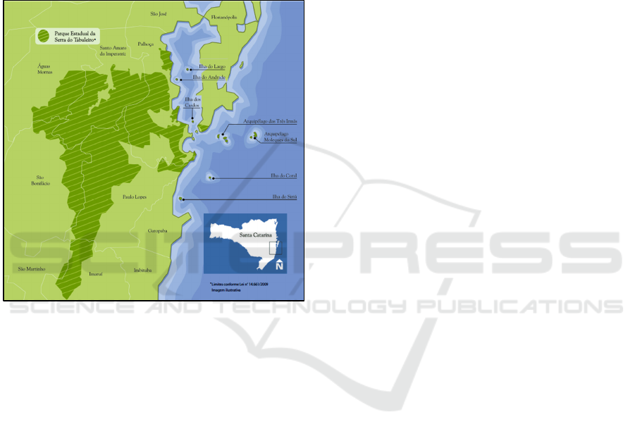
Figure 1: Location map of a Conservation Unit (a legally
Protected Area) named Serra do Tabuleiro State Park, lo-
cated in the eastern region of the State of Santa Catarina
(Brazil). Area 84,130 hectares. The Park was created in
1975 (IMA, 2024).
2 MATERIAL AND METHODS
2.1 Coordinate Reference Systems
(CRSs) for Brazil
The Coordinate Reference Systems used in Brazil
were (in historical order): Córrego Alegre, Astro
Datum Chuá, SAD69, and currently SIRGAS2000.
SAD69 stands for South American Datum 69.
SIRGAS2000 stands for “Sistema de Referência
Geocêntrico para as Américas 2000”, or Geocentric
Reference System for the Americas 2000.
Initially, the Córrego Alegre coordinate reference
system (CRS) was the first horizontal CRS used in
Brazil, remaining in use until the early 1970s. It was
briefly succeeded by Astro Datum Chuá, until the
official adoption of SAD69 in 1977. In 1996, an
updated version, known as SAD69(96), was
introduced to refine the system. Then, in 2005, the
IBGE issued a resolution designating SIRGAS2000
as Brazil’s official CRS. A transition period of up to
ten years was established, during which
SIRGAS2000 could be used alongside SAD69. This
transition period concluded in 2015
As it is customary within the geoprocessing
community, Coordinate Reference Systems (CRSs)
are represented by EPSG codes, which are numbers
up to five digits that represent and catalogue
definitions of different CRSs. The acronym EPSG
originated from the now-defunct European Petroleum
Survey Group. In practical terms of EPSG
nomenclature, the following apply for Brazil,
considering only the SAD69 and SIRGAS2000
reference systems, and focusing solely on planimetric
coordinates (UTM):
- A. EPSG 29192 – SAD69 (Classic Network).
According to the system description from the EPSG
Geodetic Parameter Dataset website
(https://epsg.org), it is possible to verify that, in
Brazil, this system was replaced by the SAD69(96)
system (code 5532, deprecated). Another source
(https://epsg.io) identifies EPSG code 5858 as a
replacement for code 29192.
- B. EPSG 5858 – SAD69(96). The obtained
description indicates that this system replaces EPSG
29192 and was, in turn, replaced by EPSG code
31982 (SIRGAS2000).
- C. EPSG 31982 – SIRGAS2000. This is the EPSG
code officially used in Brazil for projects and surveys
involving geoprocessing.
Brazil presents an additional complexity, as there
is another reference system not previously mentioned.
In addition to the reference systems with cited EPSG
codes (29192, 5858, and 31982), there is also a
reference system known as “SAD69/96 Doppler
Technique or GPS”.
Brazilian Institute for Geography and Statistics
(IBGE) provides a platform (an application) for
transforming coordinates between different official
geodetic reference systems used in the country. The
application (available as both a desktop and online
version) allows coordinate transformations between
the Córrego Alegre, SAD69, and SIRGAS2000
systems. It is a straightforward and objective tool to
support the geospatial data user community in the
transition to SIRGAS2000. The platform/application
is named ProGRID (IBGE, 2009).
Navigating Boundary Discrepancies in SAD69-Based Delimitation: A Case Study and Practical Guidelines
151

In this work, the three transformations in ProGriD
that accept SAD69 as the input reference were used.
Thus, in addition to the systems with EPSG codes
cited in the previous section (EPSGs 29192, 5858,
and 31982), the “SAD69/96 Doppler Technique or
GPS” reference system is also a possible input
reference for data.
2.2 Shapefile Sources for the Park
The polygon that represents the Park's boundaries is
available for download on a platform maintained by
the management body, which we'll call the Map
Library (ML polygon). The information is
georeferenced and presented in vector, raster and
WMS formats, all designed for use in the UTM
SIRGAS 2000 coordinate reference system
(EPSG:31982).
The Map Library is widely used by government
bodies and society in general. One can download the
existing files from the Map Library, from which the
layer corresponding to the Park's boundaries was
extracted, using the SIRGAS2000 Coordinate
Reference System (IMA, 2023).
However, the Park's boundaries are also available
on the Management Body's website, catering for
those users who don't want to or don't know how to
navigate the Map Library, preferring to go directly to
the desired shapefile. But we point out that this
shapefile unfortunately uses the SAD69 Reference
System, although it should represent the same official
polygon.
Despite the availability and practicality,
unfortunately a practical problem was risen, since
there are two official sources (from the Management
Body) that provide the Park's delimitation polygons:
the Map Library and the website, each with a different
Coordinate Reference System (SIRGAS2000 and
SAD69).
2.3 ML and CB Polygons
The first source (Map Library) shows these features
using the Coordinate Reference System cataloged as
EPSG:31982, which correctly represents the
Planimetric Coordinate System recommended for
Brazil: UTM 22J SIRGAS 2000. The delimitation
obtained will henceforth be referred to simply as the
ML Polygon or simply ML.
The second source, which shows the ‘Current
Boundaries’ of the Park, henceforth referred to
simply as CB Polygon or CB for short, shows the
features using the Coordinate Reference System
cataloged as EPSG:29192, which represents the UTM
zone 22S SAD69 Planimetric Coordinate System.
At first, it would be indifferent to use either file,
as they should produce the same result. However,
when importing the two files (ML and CB) into
geoprocessing software, a small difference in
positioning was observed between the polygons,
which are displaced by distances of around one
meters(average difference of 1.2 meters).It should be
noted as a very important feature, that the importing
of the file with EPSG:29192 can be automatically
subjected to an on-the-fly transformation by the
geoprocessing software, depending on the settings
stipulated by the user.
Naturally, this just-a-few-meters-difference is not
acceptable for forensic purposes, and therefore the
user will decide to ‘reproject’ the website file (CB
polygon, EPSG:29192) to EPSG:31928, which is the
CRS recommended for official use in Brazil.
Routinely, reprojection is recommended so that the
file can be correctly used in geoprocessing software
to obtain measurements such as distances and areas.
Normally, reprojection does not produce any adverse
results.
However, when reprojecting the shapefile
obtained from the site file (CB polygon) into
EPSG:31928, the processing software QGIS
Geographic Information System offers TWO options
for data transformation (QGIS, 2023).
Using transformation 1, the same polygon
produced by the on-the-fly transformation is obtained
(with the same difference of around one meter from
the Map Library file ML). The polygon resulting from
this transformation will henceforth be called CB1
(Figure 2).
If the user chooses transformation 2, it will be
obtained a polygon that is displaced by more than
three meters in relation to the Map Library polygon
(average difference of 3.6 meters). The polygon
resulting from this transformation will henceforth be
called CB2 (Figure 2).
In fact, to make an informed choice, users should
be aware that there are three distinct
"materializations" of SAD69: (1) SAD69 Classic, (2)
SAD69/96, and (3) SAD69 based on Doppler
Technique or GPS. The user must identify which
network the maps and databases belong to, and how
they were determined, since these 3 networks
(SAD69 Classic Network, SAD69/96 and SAD69
Doppler Technique or GPS) have different distortion
patterns. Improper use leads to erroneous results
(IBGE, 2009).
GISTAM 2025 - 11th International Conference on Geographical Information Systems Theory, Applications and Management
152
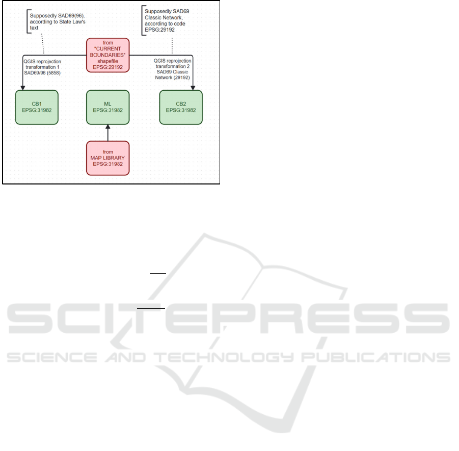
Figure 2: Three polygons obtained for the Park’s boundary,
depending on the decisions made by the user. The 3 poly-
gons are slightly displaced geographically, in the order of
meters.
Two methods were used by our group in our quest
to find the correct polygon among the 3 possible
polygons (ML, CB1 and CB2). The first method was
based on reconstructing the polygon from the
planimetric coordinates of the Park's borders,
presented in the State Law. The second method was
based on a comparison between the polygons
obtained (ML, CB1 and CB2) and some physical
remnants of the Park's boundaries, in the form of
some existing fragments of a "Park fence", physically
existing in a few remaining regions.
3 RESULTS
3.1 Reconstruction of the Park's
Boundary Polygon from the
Coordinates of the Points Reported
in the State Law
The Park's polygon was reconstructed based on the
planimetric coordinates of the existing points in the
State Law (706 points for the polygon). Our group
faced some basic problems in the definitions of the
points. The first divergence is that point 229 was
duplicated and showed different coordinates.
The second divergence is that point 299 was not
on the list. It was probably the duplicated point 229
that was typed in wrong. It was then assumed that the
entry for the second point 229 was actually point 299.
The third divergence is a series of mistakes. From
point 327 to point 340 (14 points in total), each record
was duplicated. Fortunately, the coordinates were
also duplicated, except for point 335, where the
coordinates of the duplicated points were different
(differences of approximately 38.7mE and 52.3mN).
In this case, it was assumed that the correct
coordinates would be from the first entry of duplicate
point 335.
The fourth divergence was point 687, which was
left unattributed and therefore assumed not to be part
of the polygon.
The fifth problem was that the coordinate
reference system for which the coordinates are
defined is not fully explained in the State Law text,
which only mentions the SA69 system (but as we
have already seen, there are three possible SAD69
“flavors”).
The purified set of coordinates was then used as
input for reprojection using QGIS software and for
reprojection using the ProGriD platform. For each
reprojection platform, the three possible alternatives
for the input coordinate reference system were
considered.
3.1.1 Reprojection via QGIS
Considering some of the information in the State
Law’s text, the user could interpret that this is post-
1996 SAD69 data, which would lead to the
conclusion that the coordinates would be from the
SAD69/96 network (EPSG:5858). By reprojecting
the file with this choice of EPSG:5858, a polygon is
obtained that coincides with polygon CB1 (Current
Boundaries with transformation 1, which is the
SAD69(96) transformation).
If the user interprets that the coordinates refer to
SAD69 Classic Network points (EPSG:29192), the
reprojection may result in the CB1 polygon or the
CB2 polygon, depending on the transformation
option chosen during the reprojection. The
possibilities and results were summarized and
schematized in Figure 3.
3.1.2 Reprojection via ProGriD
To ensure the transformation with the correct
parameters, the planimetric coordinates presented in
the State Law were also processed using ProGriD.
The platform requires an email address to return the
results to, when the input file is very large. Examples
of input files on the platform’s website are useful for
properly formatting the input data (IBGE, 2009).
Using ProGriD processing on the same input as
before, dully formatted, the following results were
obtained (see a summary and illustrative diagram in
Figure 3):
Navigating Boundary Discrepancies in SAD69-Based Delimitation: A Case Study and Practical Guidelines
153
a. Assuming SAD 69 Classic Network as the correct
input reference, points coinciding with the CB2
polygon are obtained.
b. Assuming SAD 69/96 as the correct input
reference, points coinciding with the ML polygon are
obtained.
c. Assuming SAD 69/96 Doppler Technique or GPS
as the correct input reference, points coinciding with
the CB1 polygon are obtained.
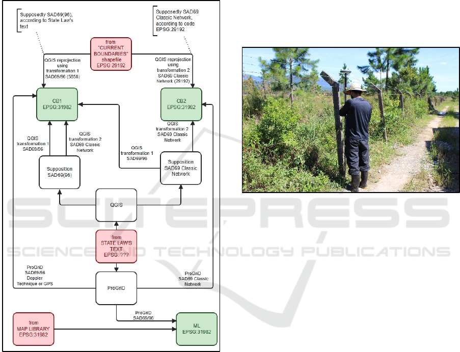
Figure 3: Representative diagram that summaries all the al-
ternatives considered and discussed in this work. The quest
to reconstruct the Park's polygon by importing and repro-
jecting the coordinates provided, using QGIS software,
leads to the CB1 and CB2 polygons described in the text.
By using the transformations available in ProGriD, our
group obtained the CB1, CB2 and ML polygons described
in the text.
3.2 Comparison Between the "Park
Fence" and the Park Polygons
A second method that was used to try to define the
most suitable polygon was based on the existence of
some fragments of a fence that would delimit portions
of the Park. These fragments of the "Park fence" are
well known in the surrounding communities and are
generally respected as being the local boundaries of
the Park, both by the local community and by
institutional representatives (Environmental Military
Police, Scientific Police and municipal environmental
management bodies).
On 13/Dec/2023, several points of the fence were
visited and the planimetric coordinates of the base of
the fence-posts were taken. In this study, precise
planimetric coordinates were obtained using the Real-
Time Positioning (RTK) network technique (Figure
4).
Figure 4: In December 2023, several remaining fragments
of the Park’s fence were visited. The precise planimetric co-
ordinates of various points representing the geometry of the
fence were recorded.
This technique uses reference stations to generate
and transmit corrections to the mobile receiver via the
NTRIP protocol. For this survey, the Brazilian
Network for Continuous Monitoring of GNSS
systems in real time (RBMC-IP), the official IBGE
network, was used. The reference station used was
located in the campus of the Federal Institute of Santa
Catarina (IFSC), in the city of Florianópolis, because
it was the closest base. Transmitting the corrections
in real time to the mobile receiver in the field allows
for a significant reduction in positioning errors,
ensuring that coordinates are obtained with high
precision, to the nearest centimeter.
The limiting factor for using the networked RTK
system is related to the transmission range of the radio
waves. In our case, the distance between the base
station (IFSC) and the mobile station was no more
than 25 kilometers in a straight line, a fully acceptable
distance for this positioning method and the
topography of the area to be surveyed.
The 20 points sampled (excluding outliers) were
imported into QGIS and compared with the polygons
mentioned above (ML, CB1 and CB2 polygons). The
points obtained do not coincide exactly with any of
GISTAM 2025 - 11th International Conference on Geographical Information Systems Theory, Applications and Management
154
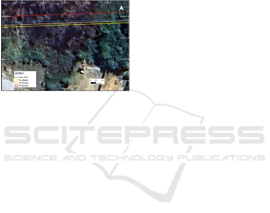
the 3 polygons (Figure 5). However, the samples of
the fence coordinates show a greater proximity to
polygon CB1 (distance 𝜇=0.19 meters 𝜎=0.14
meters). The points fall at greater distances from the
ML polygon (distance 𝜇=0.62 meters 𝜎=0.21 meters)
and the CB2 polygon (distance 𝜇=2.85 meters 𝜎=1.26
meters).
Figure 5: The fragments of the "Park fence" are not exactly
aligned with the polygons analyzed, but they are closer to
the CB1 polygon. Map produced by the authors, using
QGIS 3.30.1-'s-Hertogenbosch. Coordinates are stated in
UTM22J SIRGAS2000 (EPSG:31982).
4 DISCUSSION
IBGE Resolution No. 1/2005 established
SIRGAS2000 as the new CRS for the Brazilian
Geodetic System. A transition period of ten years was
granted (expired in 2015), allowing SIRGAS2000 to
be used concurrently with SAD69The Map Library
file ML provides a polygon referenced using the
EPSG:31982 UTM SIRGAS 2000 system (which is
currently the official coordinate reference system in
Brazil).
The 'Current Boundaries' file shows the shapefile
referenced using SAD69 Classic Network
(EPSG:29192), in non-compliance with IBGE
Resolution 1/2005
The "Current Boundaries" file can provide two
polygons, depending on the user's interpretation: (1)
polygon CB1, assuming that the data is referenced to
the SAD69/96 system (as suggested by the dates in
the description in the State Law’s text); (2) polygon
CB2, assuming that the data is referenced to the
SAD69 Classic Network system (as suggested by the
EPSG:29192 code used in the available shapefile).
When using ProGriD platform to transform the
Park's boundaries coordinates (informed in the State
Law), the same three polygons are obtained,
depending on the choice between three possible
transformations: SAD 69 Classic Network (provides
CB2); SAD 69/96 (provides ML); and SAD 69/96
Doppler Technique or GPS (provides CB1).
The polygon in the map library (ML) and the two
polygons from the 'Current Boundaries' file (CB1 and
CB2) do not coincide, which could lead to problems
in the characterization of the Park's border.
Furthermore, the points obtained as a sample for
the "Park fence" do not coincide with any of the three
polygons, although they are closer to the CB1
polygon.
Although the field GPS data suggest an advantage
in using the CB1 coordinate reference system, the
challenges in coordinate transformations prevented a
clear conclusion regarding the most suitable system
for defining the park's boundaries. The discrepancies
between the various transformation methods—such
as SAD69 Classic Network, SAD69/96, and the
Doppler Technique—resulted in inconsistent
outcomes. This lack of alignment between the
transformations, combined with uncertainties in the
input data, complicated the decision-making process.
Despite the GPS data favoring CB1, the differences
between the transformed polygons and the park's
boundary points highlight the difficulty in selecting a
definitive coordinate reference system. These issues,
along with the lack of consensus in transformation
systems, are discussed in greater detail in the
alternatives analyzed below.
Alternative A. Assuming the data were from SAD69
Classic Network, the CB2 polygon would be obtained
using both the QGIS reproject and ProGrid
transformation. It is reasonable to assume that the
input data is in the SAD69 Classic Network system,
since this is stated in the EPSG of the shapefile
(EPSG 29192), but the text of the State Law suggests
otherwise. Furthermore, the CB2 polygon obtained is
the one furthest away from the "Park fence".
Alternative B. If the data were from the SAD69/96
system, then the CB1 polygon would be obtained
(using the QGIS reproject), but the ML polygon
would be obtained (with the ProGriD transformation).
It is reasonable to assume that the data is from this
reference system, due to the dates declared in he State
Law’s text. However, this produces two different
polygons, with the ML polygon being favored
because it was produced by ProGriD, which is the
official transformation platform. However, the points
collected from the "Park fence" are closer to the CB1
polygon and not the ML polygon.
Alternative C. Assuming that the data were
originated from the SAD69/96 Doppler Technique or
GPS system, then the CB1 polygon would be
Navigating Boundary Discrepancies in SAD69-Based Delimitation: A Case Study and Practical Guidelines
155

obtained (with the appropriate ProGriD
transformation). It's reasonable to assume that the
data is from this system, because in this case you get
the polygon that is closest to the points collected from
the "park fence" fragments.
By disregarding alternative A, two viable
polygons remain: CB1 and ML. If CB1 were to be
established as the legitimate polygon, there would be
a number of implications that would make this option
costly and not defensible..The first consequence
would be the need to reconstruct the Park's polygon
to replace the existing one in the Map Library.
When considering the ML polygon as correct, it
can be seen that the only way to obtain this polygon
from the points in the State Law’s text, would be to
use ProGriD with the transformation that considers
the origin of the data in the SAD69/96 system. If this
is the correct polygon, it is important to note that the
points collected near the fragments of the Park's fence
do not coincide with this polygon, but are a certain
distance apart (𝜇=0.62 meters 𝜎=0.21 meters).
5 CONCLUSION
Under the light of the discussions in this study, our
group has produced the following recommendations
as a contribution to public authorities and Santa
Catarina society.
Recommendation 1 – Recommendation to the State
Government that the Managing Body expressly and
unequivocally define which shapefiles (UTM 22S
SIRGAS 2000 EPSG:31982) correctly define the
Park's polygons.
Recommendation 2 - Recommendation that users
always use shapefiles reprojected to EPSG:31982,
refraining from using on-the-fly transformations.
Whichever network is selected for importing the
points (SAD69 Classic Network or SAD69/96), the
user must take appropriate care when "reprojecting"
the points to the UTM 22 SIRGAS 2000 reference
system (EPSG:31982), as choosing the wrong
transformation can lead to positional errors of the
order of a few meters.
Recommendation 3 - Recommendation that users
always obtain information or confirmation of the
origin of the data when using SAD69 coordinates, so
as not to confuse SAD69 Classic Network data,
SAD69/96 data and SAD69/96 Doppler Technique or
GPS data. When importing into QGIS, pay attention
to the deprecated codes. The EPSGs 29192 (SAD69
Classic Network), 5858 (SAD69(96)) and 31982
(SIRGAS 2000) should be used.
Recommendation 4 – The park's fence does not
coincide with the Map Library’s original polygon.
However, the fence has been respected by the
communities and has been used as a marker by the
Environmental Military Police and the Scientific
Police. The government should clarify the role played
by this so-called park fence in the regions where this
structure remains.
REFERENCES
Cain, J. Coordinate Reference Systems (Best Practices for
Assignment, Manipulation and Conversion in GIS Sys-
tems). ESRI Petroleum GIS Conference: 39. 2013.
IMA. Geoseuc Geographic Information System. Available
at http://geoseuc.ima.sc.gov.br/#/, accessed in
April/2023.
IMA. Santa Catarina State’s Environmental Institute. Insti-
tuto do Meio Ambiente de Santa Catarina (IMA). Par-
que Estadual da Serra do Tabuleiro. Accessed in
April/2024: https://www.ima.sc.gov.br/.
EPSG. EPSG Geodetic Parameter Dataset: v11.001. Avail-
able at https://epsg.org. Accessed on 01/04/2023.
IBGE. ProGriD - Transformation of Coordinates between
Official Reference Systems. Brazilian Institute of Ge-
ography and Statistics. 2009. Available at
www.ibge.gov.br/geociencias.
QGIS. QGIS Development Team. QGIS Geographic Infor-
mation System. Accessed on 01/12/2023. Available at
https://www.qgis.org.
SANTA CATARINA. State Law 14661/2009. Available at
http://leis.alesc.sc.gov.br. Accessed on 01/08/2023.
SANTA CATARINA. State Decree 3446/2010, of 10 Au-
gust 2010. Available at http://leis.alesc.sc.gov.br. Ac-
cessed on 01/08/2023.
GISTAM 2025 - 11th International Conference on Geographical Information Systems Theory, Applications and Management
156
