
A Modular Detection System for Smart Cities: Integrating Monocular
and LiDAR Solutions for Scalable Traffic Monitoring
Javier Borau-Bernad
1 a
,
´
Alvaro Ramajo-Ballester
1 b
, Jos
´
e Mar
´
ıa Armingol Moreno
1 c
and
Araceli Sanchis de Miguel
2 d
1
Intelligent Systems Lab, University Carlos III of Madrid, Av. de la Universidad, 30, Legan
´
es, 28911, Madrid, Spain
2
Control Learning and Systems Optimization Group, University Carlos III of Madrid, Av. de la Universidad, 30,
Legan
´
es, 28911, Madrid, Spain
Keywords:
3D Object Detection, Intelligent Infrastructures, Smart Cities, Autonomous Driving, Deep Learning.
Abstract:
As smart cities continue to develop, they require scalable and efficient traffic monitoring systems. This paper
presents a modular detection system that switches between monocular and multimodal modes, depending on
the available sensors. The monocular mode, based on the MonoLSS algorithm, offers a cost-effective vehicle
detection solution using a single camera, ideal for simpler or low-budget setups. In contrast, the multimodal
mode integrates camera and LiDAR data via the MVX-Net model, enhancing 3D accuracy in complex traffic
scenarios. This dual-mode flexibility allows smart cities to adapt the system to their infrastructure and bud-
getary needs, ensuring scalability as urban demands evolve. Inference results demonstrate the superior accu-
racy of the multimodal approach in challenging environments while validating the efficiency of the monocular
mode for simpler settings. Therefore, the modular detection system offers a flexible solution that optimizes
both cost and performance, effectively addressing the varied requirements of smart city traffic management.
1 INTRODUCTION
As urban environments continue to grow and become
more complex, the rise of smart cities represents a so-
lution to make them more efficient, sustainable, and
secure, improving the quality of life for their resi-
dents. Smart cities leverage cutting-edge technologies
to create advanced systems that manage resources,
optimize energy usage and enhance transportation
systems (Zanella et al., 2014). Among these systems,
intelligent vehicle detection plays a key role in im-
proving traffic management, advancing autonomous
vehicle capabilities and increasing road safety. How-
ever, many current detection solutions either lack suf-
ficient data quality for real-time analysis or rely on
the widespread adoption of autonomous vehicles in
the traffic system (Jain et al., 2019). Addressing these
limitations requires the development of scalable solu-
tions that can deliver high quality traffic data analysis.
Intelligent infrastructures emerge as a key com-
ponent for traffic monitoring by integrating sensors
and analysis algorithms into urban elements such
a
https://orcid.org/0009-0009-5623-1688
b
https://orcid.org/0000-0001-9425-9408
c
https://orcid.org/0000-0002-3353-9956
d
https://orcid.org/0000-0002-1429-4092
as traffic cameras and bridge-mounted surveillance
systems. These infrastructure-based sensors offer
a broader field of view and reduce occlusions be-
tween vehicles, allowing detection algorithms to sig-
nificantly improve precision (Borau Bernad et al.,
2024). The strategic placement of roadside sensors
also plays a key role in improving detection accuracy
and minimizing blind spots, particularly in urban ar-
eas where efficient coverage is essential(Owais and
Shahin, 2022). This is particularly beneficial in high-
risk areas, like intersections, where dense traffic and
low visibility complicate effective monitoring.
Despite these advantages of intelligent infrastruc-
tures, the challenge of developing a flexible solution
that adapts to different precision requirements appears
in the research paradigm, to guarantee optimal per-
formance across diverse urban settings. Monocular
detection systems present themselves as an afford-
able and simple solution for 3D vehicle detection, but
are challenged by their limitations in depth estimation
and lighting conditions. In contrast, multimodal de-
tection systems, which integrate LiDAR and monoc-
ular technologies, provide higher 3D accuracy but
come with increased installation costs (Wang et al.,
2023). The challenge in this context lies in designing
a flexible solution that can satisfy different installa-
tion needs while balancing cost and performance.
326
Borau-Bernad, J., Ramajo-Ballester, Á., Moreno, J. M. A. and Sanchis de Miguel, A.
A Modular Detection System for Smart Cities: Integrating Monocular and LiDAR Solutions for Scalable Traffic Monitoring.
DOI: 10.5220/0013195200003941
In Proceedings of the 11th International Conference on Vehicle Technology and Intelligent Transport Systems (VEHITS 2025), pages 326-333
ISBN: 978-989-758-745-0; ISSN: 2184-495X
Copyright © 2025 by Paper published under CC license (CC BY-NC-ND 4.0)

This paper presents a modular detection system
designed to operate in two distinct modes, offering
flexibility and adaptability to diverse urban infrastruc-
tures. The system can work as a monocular solution,
using the MonoLSS algorithm (Li et al., 2024), which
provides a cost-effective and simpler approach for ve-
hicle detection. Alternatively, it can operate as a mul-
timodal system, integrating both LiDAR and monoc-
ular data through the MVX-Net model (Sindagi et al.,
2019) to enhance 3D accuracy in more demanding en-
vironments. Unlike previous approaches that rely on
fixed monocular or multimodal configurations, this
system introduces a novel dynamic mode selection
based on sensor availability. This modular design
enhances the scalability of smart infrastructures, en-
abling cities to deploy the solution based on their spe-
cific needs, budget and available sensor installations,
making it versatile across different urban settings.
2 RELATED WORKS
The growing interest in developing technologies for
smart cities has fueled the advancement of intelligent
traffic monitoring systems. While monocular meth-
ods provide an affordable and simple solution, they
struggle with depth estimation errors and rely heav-
ily on certain visibility conditions for optimal perfor-
mance. In contrast, LiDAR and multimodal systems
offer improved detection accuracy and perform well
under low visibility conditions, though at a higher
system cost (Arnold et al., 2019). This section re-
views the key advancements in vehicle detection sys-
tems, highlighting state-of-the-art models, their lim-
itations and the need for a flexible modular solution
that can harness the strengths of each approach based
on the specific needs of intelligent infrastructure.
Monocular detection systems have emerged as an
attractive solution for urban data acquisition due to
their affordability and ease of deployment. These
systems consist of a single-camera setup that cap-
tures 2D images, which are processed by deep learn-
ing algorithms to obtain three-dimensional vehicle
information. The simplicity of monocular systems
makes them suitable for cities with limited installation
budgets, as they only require conventional calibrated
camera setups and a computational unit to process the
information. This cost-effectiveness and their easy in-
tegration into existing infrastructure make monocular
systems an interesting tool for large-scale deployment
in intelligent traffic monitoring solutions.
During the last decade, several deep learning mod-
els have been developed to improve existing monoc-
ular detection algorithms. The SMOKE model (Liu
et al., 2020) is known for its efficiency, speed and sim-
plicity, performing 3D inference in a single stage. On
the other hand, PGD algorithm (Wang et al., 2022)
enhances depth estimation by combining probabilis-
tic and geometric methods to improve detection accu-
racy. MonoCon (Liu et al., 2022) leverages additional
contextual information during training, improving de-
tection accuracy in crowded environments. Lastly,
MonoLSS introduces a Learnable Sample Selection
(LSS) module, optimizing the use of features during
3D property learning and uses MixUp3D augmenta-
tion technique to enhance training data, making the
algorithm highly robust against occlusions.
Despite these advancements, monocular detection
systems still face important limitations, mainly due to
errors during depth estimation and their sensitivity to
non-optimal environmental conditions. The process
of inferring three-dimensional information from 2D
images causes the models to have significant errors,
which has a direct impact on the final accuracy of the
algorithm. In addition, monocular systems are partic-
ularly affected by low visibility situations, such as ad-
verse weather conditions, as well as low light during
night or direct sunlight hitting the camera lens during
sunrise or sunset, notably reducing their capabilities
and precision (Qian et al., 2022). These limitations
establish the need for integration of more robust so-
lutions, leading to the exploration of LiDAR-based
detection systems, which offer enhanced depth per-
ception and accuracy but at a higher cost.
LiDAR-based systems overcome many of the is-
sues of monocular approaches by inferring detection
from 3D point clouds generated by laser pulses, re-
sulting in better depth and position accuracy regard-
less of light conditions, making them more reliable
in complex urban environments. Notable LiDAR-
based models include SECOND (Yan et al., 2018),
which uses sparse convolutions to efficiently process
LiDAR point clouds and PointPillars (Lang et al.,
2019), a method that organizes point clouds into verti-
cal columns for faster processing. Another advanced
approach is VoxelNet (Zhou and Tuzel, 2018), which
divides the point cloud space into 3D voxels and ex-
tracts features for object detection.
However, LiDAR systems face significant chal-
lenges that limit their widespread adoption in Smart
Cities. These include high sensor costs, complex in-
stallation and maintenance requirements, such as fre-
quent calibration and cleaning, and reduced robust-
ness in adverse weather conditions like heavy rain or
snow (Owais, 2024). Table 1 provides a comparative
analysis of monocular camera systems and LiDAR-
based systems, highlighting the advantages and dis-
advantages of each sensor type.
A Modular Detection System for Smart Cities: Integrating Monocular and LiDAR Solutions for Scalable Traffic Monitoring
327

Table 1: Comparison of Camera and LiDAR sensors under different environmental conditions, considering the impact of
adverse conditions, color capabilities, installation complexity and cost (Zhang et al., 2023).
Sensor type Light rain Heavy rain Smog Snow Strong light Color Complexity Cost
Camera Mid High High Mid High Yes Low Low
LiDAR Low Mid Low High Low No High High
Multimodal detection systems combine the
strengths of both cameras and LiDAR, integrating
2D image data with 3D point clouds to achieve more
accuracy and robustness in vehicle detection. These
systems can capture both the visual information
needed for tasks like license plate recognition,
while also benefiting from the depth and spatial
accuracy provided by LiDAR. A good example of
this approach is MVX-Net, which fuses camera and
LiDAR data to generate highly accurate 3D object
detections. By combining the complementary fea-
tures of both sensors, multimodal systems overcome
the limitations of using only image or LiDAR solu-
tions, particularly useful in highly demanding traffic
situations with poor visibility or occlusions. Despite
these advantages, the integration of multiple sensors
increases both the hardware costs and the complexity
of the system, presenting challenges for widespread
deployment in cost-sensitive urban infrastructures.
Monocular, LiDAR and multimodal systems each
offer distinct advantages but also come with trade-offs
in cost, complexity and performance. Monocular sys-
tems are affordable but struggle with depth accuracy,
while LiDAR systems are precise but expensive and
limited in capturing visual details like color or license
plates and multimodal systems provide a balance but
increase overall costs. To address these challenges,
this paper proposes a modular detection system that
operates in monocular and multimodal modes, allow-
ing for flexible deployment based on urban infrastruc-
ture needs, balancing cost and accuracy.
3 OUR APPROACH: MODULAR
DETECTION SYSTEM
To address the challenges resulting from varied traffic
demands, this section introduces a modular detection
system for intelligent infrastructures that can operate
in both monocular and multimodal modes, depend-
ing on the inputs received from the sensors. The sys-
tem dynamically selects the appropriate mode based
on real-time data to maximize the effectiveness of the
intelligent infrastructure. This solution provides the
flexibility needed to adapt to different urban environ-
ments while balancing cost and performance require-
ments, guaranteeing scalability for smart cities.
3.1 System Architecture
The modular detection system is designed to effi-
ciently handle both monocular and multimodal data
inputs, enabling it to adapt to various urban infras-
tructure setups. The system autonomously selects
between these modes based on the sensors available
at the infrastructure setup, ensuring optimal opera-
tion regardless of the installed sensors and making it
an adaptable solution for 3D data acquisition. This
adaptability is critical for ensuring that diverse urban
environments, with different levels of technological
infrastructure, can still benefit from the detection sys-
tem’s advanced capabilities.
The system is built around two core components:
one for monocular detection and another for multi-
modal detection, which are automatically selected by
the system depending on the installed sensors. If
only camera data is available, the system activates
the monocular mode, processing the images with a
monocular 3D detection model to perform 3D vehi-
cle detection in cost-effective configurations. In con-
trast, when both camera and LiDAR are connected,
the system switches to multimodal mode, leverag-
ing enhanced detection capabilities for more complex
situations. This transition from monocular to multi-
modal mode requires minimal infrastructure modifi-
cations. Existing monocular setups can be upgraded
with LiDAR sensors and updating software to enable
multimodal data processing.
The applications of each module vary based on the
needs of the infrastructure environment. Monocular
mode is well-suited for areas with budget constraints
or less complex traffic, such as smaller cities or high-
visibility intersections where camera-based systems
can guarantee accurate vehicle detection. On the other
hand, multimodal mode is designed for more demand-
ing situations, integrating LiDAR and camera data to
provide enhanced detection in complex traffic condi-
tions. This mode is ideal for busy intersections, envi-
ronments with poor visibility, or locations frequently
affected by bad weather conditions.
Additionally, the flexibility and ease of installa-
tion of the modular system provide significant advan-
tages for smart cities development. Monocular setups
can be integrated into existing infrastructure cameras,
allowing for affordable deployment and scalability
over time. As cities evolve and develop, the system
VEHITS 2025 - 11th International Conference on Vehicle Technology and Intelligent Transport Systems
328

can easily transition from monocular to multimodal
mode without manual intervention, enabling more ad-
vanced detection capabilities without requiring com-
plete infrastructure redesign. This scalability makes
the system a sustainable long-term solution, allow-
ing cities to gradually enhance their traffic monitor-
ing capabilities as resources and infrastructure allow.
The system’s modular design ensures that new tech-
nologies, like AI-based traffic management platforms,
advanced sensor fusion algorithms or next-generation
LiDAR and high resolution camera systems, can be
incorporated with minimal disruption, allowing for
smooth upgrades as sensor technology advances. Fig-
ure 1 illustrates the overall system architecture and
the module selection depending on the input available
from the infrastructure installed sensors.
3.2 Monocular
The monocular detection component of the modular
detection system is based on MonoLSS model (Li
et al., 2024), an advanced and well-proven algorithm
for 3D object detection using images. MonoLSS is
based on CenterNet (Zhou et al., 2019) and first cre-
ates a feature map from the image inputs using a back-
bone DLA-34 (Yu et al., 2018). Then, it leverages
a Learnable Sample Selection (LSS) module which
identifies the most relevant features from the image to
improve the precision of vehicle detection. This LSS
module is based in Gumbel-Softmax and a relative
distance sample divider and uses a warm-up schedule
to improve training stability. In addition, MonoLSS
introduces a new data augmentation technique named
MixUp3D, designed to simulate spatial overlap of
objects without introducing depth ambiguity, which
could cause errors in 3D parameter calculations.
The monocular detection module extracts 3D in-
formation, including depth, dimensions and orien-
tation of vehicles, using the MonoLSS model. To
achieve accurate 3D localization, the system relies on
the camera calibration parameters to transform from
image to real-world coordinates. This approach en-
sures consistent performance in real-time traffic sit-
uations, providing reliable 3D information even with
a single camera, making it ideal for low-cost deploy-
ments in less complex traffic environments.
3.3 Multimodal
The multimodal detection branch of the modular
detection system is based on the MVX-Net model
(Sindagi et al., 2019). This algorithm combines Li-
DAR and monocular image data to extract accurate
3D information, reducing false negatives and false
positives compared to other 3D detection approaches.
MVX-Net proposes two data fusion techniques, Vox-
elFusion and PointFusion, to integrate information
from both sensor types at different detection stages.
For the implementation of MVX-Net into the modular
system, PointFusion was selected due to its slightly
better performance compared to VoxelFusion.
PointFusion is an early fusion technique that first
uses a 2D detection network to extract the feature
maps from the images. Then, the 3D points are
projected onto the image using the camera calibra-
tion matrix and the image feature of each location
is concatenated to the correspondent LiDAR point.
These combined features are processed through Voxel
Feature Encoding (VFE) layers of VoxelNet (Zhou
and Tuzel, 2018), allowing the neural network to
learn from LiDAR and image data. This early fu-
sion method provides richer information resulting in
higher accuracy during 3D object detection.
The multimodal detection system using MVX-
Net combines LiDAR and image data to utilize the
strengths of both modalities. This fusion approach
ensures improved object detection in complex urban
scenarios, where precision is essential to guarantee
citizen safety and enhance traffic management.
4 EXPERIMENTS
4.1 Dataset
For training and implementing the algorithms that set
up the modular detection system, it is necessary to
select a dataset that includes both image and LiDAR
data and which mirrors the design of the future ap-
plication, in this case, infrastructure-based data. The
DAIR-V2X dataset (Yu et al., 2022) satisfies these
requirements, providing data from LiDAR and RGB
cameras captured from vehicles and roadside infras-
tructures. In this work, the infrastructure part of the
dataset, DAIR-V2I, was selected.
The subset originally includes 10,000 images cap-
tured with RGB 1920x1080 cameras, along with point
cloud data from LiDAR sensors which offer a hori-
zontal field of view (FOV) of 100° and a range of up
to 280 meters. The dataset contains almost 500,000
labeled annotations, including bounding boxes, ob-
ject classes and calibration files that provide camera
intrinsic parameters and camera-LiDAR calibration
information. During model training, 7,058 images
and corresponding LiDAR data from the dataset were
used, split into 80% for training, 10% for validation
and 10% for testing, ensuring a diverse data distribu-
tion that enables the model to generalize correctly.
A Modular Detection System for Smart Cities: Integrating Monocular and LiDAR Solutions for Scalable Traffic Monitoring
329
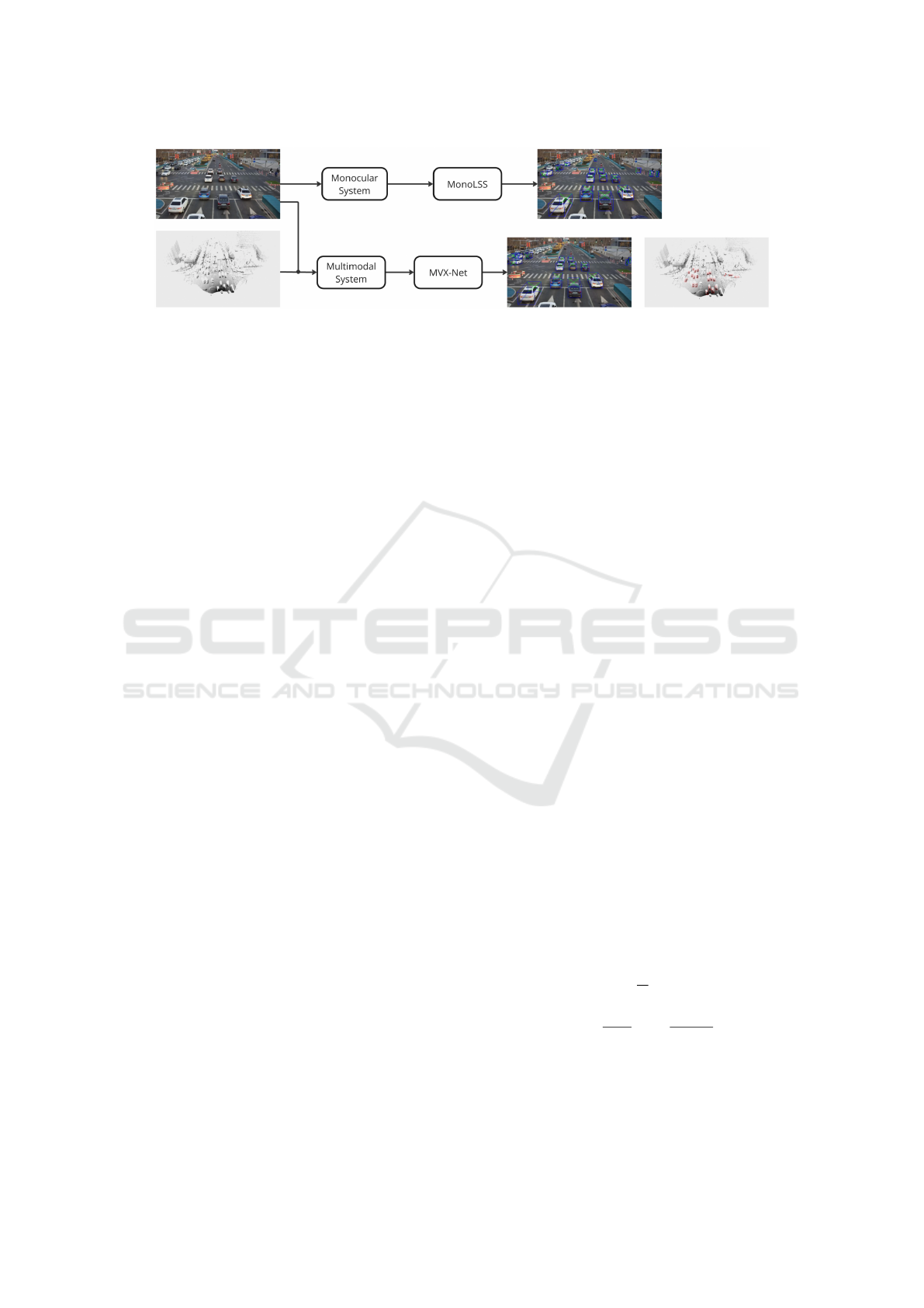
Figure 1: Overview of the modular detection system, illustrating the two core components for monocular and multimodal
detection. The system dynamically selects the detection mode based on the available sensor inputs, enabling flexible and
scalable deployment in different urban environments.
4.2 Implementation Details
The algorithms of the modular detection system were
implemented and trained on a single server equipped
with two NVIDIA GeForce GTX 3090 Ti.
The MonoLSS model was implemented using the
RoadVision3D library (Borau Bernad, 2024), which
is a custom library developed in PyTorch designed
specifically for 3D vehicle detection and traffic mon-
itoring applications. The images from the DAIR
dataset were processed in their original resolution of
1920x1080 pixels and then downsampled by a fac-
tor of 4 during feature extraction. The data aug-
mentation techniques applied include random flip-
ping with a 50% probability, random cropping with
a 50% probability, a maximum scaling factor of 0.4
and image center shifting of 0.1. Additionally, the
MixUp3D augmentation technique was applied with
a 50% probability to simulate overlapping objects.
To evaluate the impact of augmentation techniques,
we conducted an ablation study comparing training
with augmentation techniques against training with-
out augmentation for underrepresented classes like
Pedestrians and Cyclists. Augmentation techniques
significantly improved detection accuracy, increasing
AP40 for Pedestrians and Cyclists by 3.6% and 2%,
respectively, under moderate difficulty. MonoLSS
training was conducted over 150 epochs, with vali-
dation at intervals every 10 epochs, using the Adam
optimizer. The initial learning rate was set to 0.001,
with a warmup phase during the initial 5 epochs, fol-
lowed by a decay rate of 0.1 at epochs 90 and 120.
For the multimodal detection branch, the MVX-
Net model was trained using the MMDetection3D
(MMDetection3D Contributors, 2020) library, based
in PyTorch, which allows for the integration of Li-
DAR and image data to enhance 3D object detec-
tion. MVX-Net was trained using a voxel size of
[0.05, 0.05, 0.1] and a point-cloud range from [0, -
40, -3] to [100, 40, 1], with images loaded at their
original resolution of 1920x1080. The data augmen-
tation techniques included random resizing of images
between (1536, 864) and (2304, 1296), random flip-
ping with a 50% probability and random shuffling of
point cloud data. The training lasted for 60 epochs
with an AdamW scheduler, validating every 5 epochs
and used a cosine annealing learning rate that decayed
from 0.003 to 3 × 10
−6
.
4.3 Evaluation Metrics
The evaluation of the 3D detection models was con-
ducted using the Average Precision (AP) metric, com-
monly used in algorithm comparison on the KITTI
dataset (Geiger et al., 2012), a standard benchmark
for evaluating 3D object detection models. For
comparing the performance of the trained MonoLSS
and MVX-Net algorithms, we used the AP
40
metric,
which classifies ground truth objects into three levels
of difficulty: easy, moderate and hard, based on fac-
tors such as occlusions, pixel size of bounding boxes
and truncation. AP
40
is well suited for 3D traffic mon-
itoring applications as it combines recall and preci-
sion into a single metric providing a reliable measure
of overall detection performance across different sce-
narios.
The Intersection over Union (IoU) metric is used
to determine the overlap between predicted and
ground truth bounding boxes. The IoU filters detec-
tions, ensuring that only those meeting a minimum
overlap threshold are considered in the accuracy cal-
culation. Therefore, the Average Precision at 40 recall
points (AP
40
) is calculated using the following equa-
tion:
AP
R
N
=
1
N
∑
r∈R
P(r), (1)
where R = [r
0
, r
0
+
r
1
−r
0
N−1
, r
0
+
2(r
1
−r
0
)
N−1
, . . . , r
1
] defines
N equally spaced recall values between r
0
= 0 and
r
1
= 1, and P(r) is the maximum precision observed
for any recall value greater than or equal to r.
VEHITS 2025 - 11th International Conference on Vehicle Technology and Intelligent Transport Systems
330
4.4 Results
This section presents the performance evaluation of
the modular detection system, examining both the
monocular and multimodal modules. Each model was
tested using the AP
40
metric for the detection of three
object classes. The evaluation uses Intersection over
Union thresholds of 0.70 for Car and 0.50 for Pedes-
trian and Cyclist to determine true positive detections.
The results, shown in Tables 2 and 3, provide a com-
prehensive overview of how the models handle differ-
ent difficulty levels, demonstrating the robustness of
each approach in dynamic urban environments.
Table 2: Results of MonoLSS Model on AP
40
3D detection
for Car, Pedestrian and Cyclist classes at different difficulty
levels (Easy, Moderate and Hard), with IoU thresholds of
0.70 for Car and 0.50 for Pedestrian and Cyclist.
Class Easy Moderate Hard
Car 62.24 52.16 52.08
Pedestrian 15.75 14.70 14.60
Cyclist 39.44 21.04 21.35
Table 3: Results of MVX-Net Model on AP
40
3D detection
for Car, Pedestrian and Cyclist classes at different difficulty
levels (Easy, Moderate and Hard), with IoU thresholds of
0.70 for Car and 0.50 for Pedestrian and Cyclist.
Class Easy Moderate Hard
Car 69.13 56.74 56.78
Pedestrian 63.47 59.14 59.03
Cyclist 61.49 29.36 31.04
The results show that both MonoLSS and MVX-
net perform correctly for most object classes and dif-
ficulty levels, proving accurate 3D detection capabil-
ities of the modular system. However, the MonoLSS
model shows limitations in detecting pedestrians
(14.70%) and cyclists (21.04%) at moderate diffi-
culty, showcasing the limited reliability of monocu-
lar detection systems for less visible objects. Despite
this, MonoLSS remains accurate for vehicle detec-
tion, making it suitable for low-cost implementations
where cars are the primary concern. Such setups are
appropriate in environments with minimal pedestrian
or cyclist traffic, such as highways or districts farther
from the city center. On the other hand, MVX-Net
shows increased performance in all classes due to its
multimodal input source, which highlights the advan-
tage of incorporating LiDAR sensors into intelligent
infrastructures. Table 4 shows these accuracy im-
provements, particularly for pedestrians and cyclists.
In spite of the increased performance of MVX-Net
due to the integration of LiDAR, MonoLSS remains a
viable and cost-effective solution for simpler applica-
Table 4: Comparison of AP
40
3D detection performance
for Car, Pedestrian and Cyclist classes at an IoU threshold
of 0.70 for Car and 0.50 for Pedestrian and Cyclist between
MonoLSS and MVX-Net at Moderate difficulty level. This
comparison highlights the key role of multimodal detection
in improving reliability, especially for smaller objects like
pedestrians and cyclists.
Class MonoLSS MVX-Net Diff.
Car 52.16 56.74 +4.58
Pedestrian 14.70 59.14 +44.44
Cyclist 21.04 29.36 +8.32
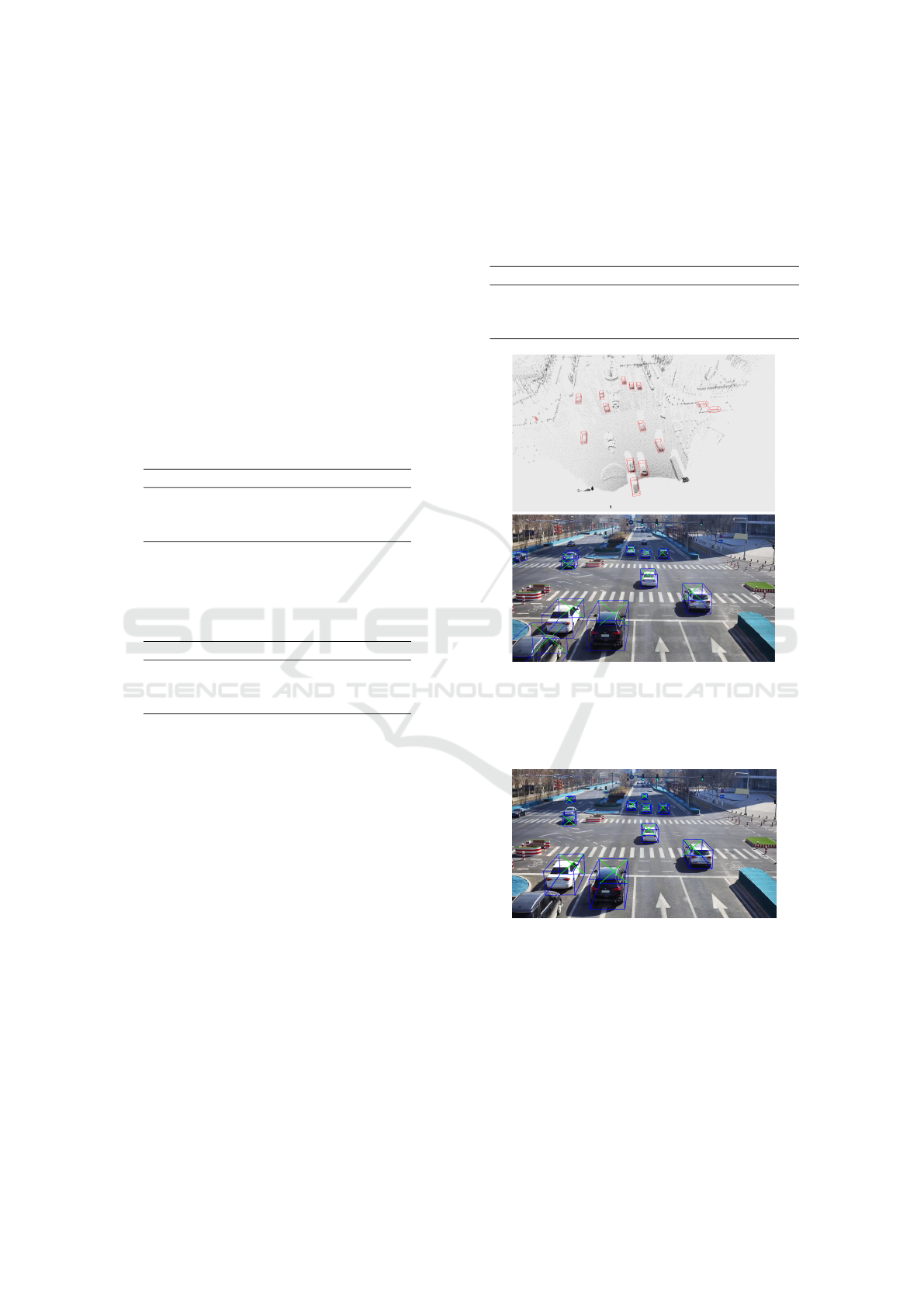
Figure 2: Inference results of the MVX-Net model, illustrat-
ing 3D object detection using LiDAR and monocular image
data, with results projected onto the point cloud and image.
This figure showcases MVX-Net’s accuracy and robustness
in vehicle detection using multimodal inputs.
Figure 3: Inference results of the MonoLSS model, demon-
strating 3D object detection capabilities using only monoc-
ular image data. This figure showcases MonoLSS’s reliabil-
ity in vehicle detection, making it suitable for cost-sensitive
scenarios.
tions due to its reliability in vehicle detection. Figures
2 and 3 illustrate the inference results of both models
in real-world conditions. These images highlight their
performance in detecting vehicles as the primary ob-
jective in traffic monitoring scenarios.
A Modular Detection System for Smart Cities: Integrating Monocular and LiDAR Solutions for Scalable Traffic Monitoring
331
4.5 Performance Evaluation Under
Challenging Conditions
Despite the overall satisfactory results obtained by
both models, it is insightful to delve into possible traf-
fic scenarios where the multimodal system might per-
form better than the monocular, benefiting from the
installed LiDAR sensors. One possible scenario in-
volves high-density traffic situations, with occlusions
and a large number of vehicles, making detection dif-
ficult for a single camera system. This scenario is il-
lustrated in Figure 4, where the multimodal system is
correctly detecting the vehicles while the monocular
one struggles and is not capable of locating all cars
going through the intersection.
Figure 4: Inference results of the MonoLSS model (top) and
MVX-Net (bottom), illustrating the differences in detection
capabilities under high-density traffic conditions.
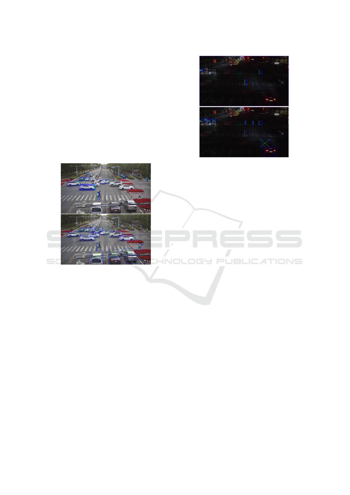
Similarly, in low-light conditions such as night op-
erations, the monocular approach is challenged due to
limited visibility and low image quality. In contrast,
the multimodal system shows its strength by using Li-
DAR data to maintain detection accuracy despite the
lack of light. Figure 5 shows experimental results in
this scenario, where low visibility significantly affects
the monocular system’s performance.
5 CONCLUSIONS AND FUTURE
WORKS
In this work, a modular detection system has been de-
signed for smart cities, capable of operating in intel-
ligent infrastructures equipped with either monocular
or multimodal sensors. This modular configuration
addresses the need for flexibility in traffic monitor-
ing by offering a monocular solution, based on the
Figure 5: Inference results of the MonoLSS model (top) and
MVX-Net (bottom), illustrating the differences in detection
capabilities under low light traffic conditions, where image
data alone is not enough for accurate detection.
MonoLSS algorithm, for simpler environments, while
enhancing detection accuracy and robustness with the
integration of LiDAR data through the multimodal
MVX-Net model. This dual-mode design allows ur-
ban environments to adapt their traffic monitoring
systems to different requirements and resource avail-
ability, balancing performance with cost efficiency.
The experiments conducted demonstrate that both
algorithms are able to provide accurate 3D vehicle
detection, ensuring effective traffic monitoring in di-
verse urban environments. The monocular module
performs correctly and accurately in most scenarios
while the multimodal configuration shows enhanced
detection capabilities in more challenging situations,
such as high density traffic or low light environments.
Overall, the results validate the effectiveness of the
modular approach in addressing a range of urban
traffic monitoring needs, demonstrating that both the
monocular and multimodal configurations work ef-
fectively under their respective conditions.
To advance this work, it is key to carry out real-
world experiments on vehicle detection to validate the
system’s efficiency under dynamic and uncontrolled
situations. Based on the results of these experiments,
it will be important to improve the system’s accuracy
and robustness, particularly in classes and situations
where it struggles. Additionally, future studies should
incorporate datasets representing diverse real-world
scenarios, including adverse weather, dense urban ar-
eas and rural regions, to enhance the generalizability
of findings and validate the system under varied en-
vironmental and traffic conditions. Such tools would
make it easier to identify bottlenecks, optimize traffic
light timing, and enhance overall urban traffic flow,
VEHITS 2025 - 11th International Conference on Vehicle Technology and Intelligent Transport Systems
332

contributing to the development of smart cities. Fur-
thermore, future research could also explore the appli-
cation of the modular detection system beyond traffic
monitoring, such as pedestrian flow analysis, public
safety enhancement or intelligent parking detection.
In conclusion, the modular detection system de-
veloped in this work advances the development of
smart cities by providing a scalable, flexible and
adaptable solution for traffic monitoring. This ap-
proach not only meets current urban mobility de-
mands but also sets a strong foundation for future in-
novations in the intelligent infrastructures field, en-
suring that cities can address the emerging challenges
in traffic safety, efficiency and sustainability.
ACKNOWLEDGEMENTS
This research was funded by MCIN/AEI/10.13039/
501100011033 grant numbers PID2021-124335OB-
C21, PID2022-140554OB-C32 and PDC2022-
133684-C31.
REFERENCES
Arnold, E., Al-Jarrah, O. Y., Dianati, M., Fallah, S., Ox-
toby, D., and Mouzakitis, A. (2019). A survey on
3d object detection methods for autonomous driving
applications. IEEE Transactions on Intelligent Trans-
portation Systems, 20(10):3782–3795.
Borau Bernad, J. (2024). RoadVision3D. https://github.
com/jborau/RoadVision3D.
Borau Bernad, J., Ramajo-Ballester,
´
A., and Armin-
gol Moreno, J. M. (2024). Three-dimensional vehicle
detection and pose estimation in monocular images
for smart infrastructures. Mathematics, 12(13):2027.
Geiger, A., Lenz, P., and Urtasun, R. (2012). Are we ready
for autonomous driving? the kitti vision benchmark
suite. 2012 IEEE Conference on Computer Vision and
Pattern Recognition, pages 3354–3361.
Jain, N. K., Saini, R., and Mittal, P. (2019). A review
on traffic monitoring system techniques. Soft com-
puting: Theories and applications: Proceedings of
SoCTA 2017, pages 569–577.
Lang, A. H., Vora, S., Caesar, H., Zhou, L., Yang, J., and
Beijbom, O. (2019). Pointpillars: Fast encoders for
object detection from point clouds. In Proceedings
of the IEEE/CVF conference on computer vision and
pattern recognition, pages 12697–12705.
Li, Z., Jia, J., and Shi, Y. (2024). Monolss: Learnable
sample selection for monocular 3d detection. In 2024
International Conference on 3D Vision (3DV), pages
1125–1135.
Liu, X., Xue, N., and Wu, T. (2022). Learning auxiliary
monocular contexts helps monocular 3d object detec-
tion. In Proceedings of the AAAI Conference on Arti-
ficial Intelligence, volume 36, pages 1810–1818.
Liu, Z., Wu, Z., and T’oth, R. (2020). Smoke: Single-stage
monocular 3d object detection via keypoint estima-
tion. 2020 IEEE/CVF Conference on Computer Vision
and Pattern Recognition (CVPR), pages 4289–4298.
MMDetection3D Contributors (2020). MMDetection3D:
OpenMMLab next-generation platform for general
3D object detection. https://github.com/open-mmlab/
mmdetection3d.
Owais, M. (2024). Deep learning for integrated ori-
gin–destination estimation and traffic sensor location
problems. IEEE Transactions on Intelligent Trans-
portation Systems, 25(7):6501–6513.
Owais, M. and Shahin, A. I. (2022). Exact and heuris-
tics algorithms for screen line problem in large size
networks: Shortest path-based column generation ap-
proach. IEEE Transactions on Intelligent Transporta-
tion Systems, 23(12):24829–24840.
Qian, R., Lai, X., and Li, X. (2022). 3d object detection for
autonomous driving: A survey. Pattern Recognition,
130:108796.
Sindagi, V. A., Zhou, Y., and Tuzel, O. (2019). Mvx-net:
Multimodal voxelnet for 3d object detection. In 2019
International Conference on Robotics and Automation
(ICRA), pages 7276–7282.
Wang, T., Xinge, Z., Pang, J., and Lin, D. (2022). Proba-
bilistic and geometric depth: Detecting objects in per-
spective. In Conference on Robot Learning, pages
1475–1485. PMLR.
Wang, Y., Mao, Q., Zhu, H., Deng, J., Zhang, Y., Ji, J., Li,
H., and Zhang, Y. (2023). Multi-modal 3d object de-
tection in autonomous driving: a survey. International
Journal of Computer Vision, 131(8):2122–2152.
Yan, Y., Mao, Y., and Li, B. (2018). Second:
Sparsely embedded convolutional detection. Sensors,
18(10):3337.
Yu, F., Wang, D., Shelhamer, E., and Darrell, T. (2018).
Deep layer aggregation. In Proceedings of the IEEE
conference on computer vision and pattern recogni-
tion, pages 2403–2412.
Yu, H., Luo, Y., Shu, M., Huo, Y., Yang, Z., Shi, Y., Guo,
Z., Li, H., Hu, X., Yuan, J., and Nie, Z. (2022). Dair-
v2x: A large-scale dataset for vehicle-infrastructure
cooperative 3d object detection. In Proceedings of the
IEEE/CVF Conference on Computer Vision and Pat-
tern Recognition (CVPR), pages 21361–21370.
Zanella, A., Bui, N., Castellani, A., Vangelista, L., and
Zorzi, M. (2014). Internet of things for smart cities.
IEEE Internet of Things journal, 1(1):22–32.
Zhang, Y., Carballo, A., Yang, H., and Takeda, K. (2023).
Perception and sensing for autonomous vehicles under
adverse weather conditions: A survey. ISPRS Journal
of Photogrammetry and Remote Sensing, 196:146–
177.
Zhou, X., Wang, D., and Kr
¨
ahenb
¨
uhl, P. (2019). Objects as
points. arXiv preprint arXiv:1904.07850.
Zhou, Y. and Tuzel, O. (2018). Voxelnet: End-to-end learn-
ing for point cloud based 3d object detection. In Pro-
ceedings of the IEEE Conference on Computer Vision
and Pattern Recognition (CVPR).
A Modular Detection System for Smart Cities: Integrating Monocular and LiDAR Solutions for Scalable Traffic Monitoring
333
