
Analysis of the Coordinated Development Mechanism Between
Urbanization and Arable Land Resource Quantity Changes in
Underdeveloped Mountainous Areas: A Case Study of Meizhou City
Yiman Chen
1a
, Wenchang Yang
2
and Yaqiu Yin
3,4,5,6,*
1
Guangdong University of Technology, Guangzhou 510520, China
2
China Institute of Geo-Environment Monitoring, Beijing 100081, China
3
Land Consolidation and Rehabilitation Center, Ministry of Natural Resources, Beijing 100035, China
4
Land Science and Technology Innovation Center, Ministry of Natural Resources, Beijing 100035, China
5
Technology Innovation Center for Land Engineering, Ministry of Natural Resources, Beijing 100035, China
6
Key Laboratory of Land Consolidation and Rehabilitation, Ministry of Natural Resources, Beijing 100035, China
*
Keywords: Urbanization Level, Arable Land Resource Quantity, Coordination, Meizhou City.
Abstract: This study examines the urbanization level and changes in arable land resources in Meizhou City, Guangdong
Province, from 1999 to 2020. It analyzes the coordination between urbanization and arable land resources,
explores their interactive relationship, and investigates the impact of coordination on economic growth. The
study employs entropy analysis and regression models to provide a scientific basis for achieving the
coordinated development of urbanization and arable land resource protection in Meizhou City.
1 INTRODUCTION
Arable land resources are fundamental and crucial for
human development, playing a vital role in the
sustainable development of regional economies
(Zhan, 2014). In China, as a populous country,
achieving self-sufficiency in food is of utmost
importance for ensuring stable development
(He et al.,
2018). Therefore, preserving arable land resources is
significant (Cheng et al., 2022). Urbanization serves
as a crucial indicator of a country's economic progress
(Chan et al., 2023). Ensuring the harmonious
development between urbanization and arable land
resources becomes a driving force for sustainable
development (Liu et al., 2022).
Meizhou City, as an underdeveloped mountainous
region, should prioritize the implementation of the
national policy of valuing and utilizing land and
protecting arable land. It should transform land use
patterns, allocate land resources efficiently, maintain
a balance in the total amount of arable land, and
facilitate the rapid development of various
construction projects (Zhao et al., 2023; Zhang,
2019). This will maximize economic, social, and
a
https://orcid.org/0009-0008-5468-036X
ecological benefits, achieving sustained and
coordinated development within the local economy
and society (Liang et al., 2019).
2 DATA AND METHODOLOGY
2.1 Study Area Introduction
Meizhou City is located in the northeastern part of
Guangdong Province, China. It is a prefecture-level
city situated at the intersection of Fujian, Guangdong,
and Jiangxi provinces. Meizhou shares a border with
Longyan and Zhangzhou in Fujian Province to the
east and is adjacent to Chaozhou, Jieyang, and
Shanwei in the south. It also connects with Heyuan in
the west and Ganzhou City in Jiangxi Province to the
north. Meizhou City holds the distinction of being a
renowned national historical and cultural city, often
referred to as the "hometown of culture" and
"hometown of overseas Chinese." Geographically,
Meizhou spans from 115°18′ to 116°56′ east
longitude and 23°23′ to 24°56′ north latitude. It falls
within the subtropical monsoon climate zone,
152
Chen, Y., Yang, W., Yin and Y.
Analysis of the Coordinated Development Mechanism Between Urbanization and Arable Land Resource Quantity Changes in Underdeveloped Mountainous Areas: A Case Study of Meizhou
City.
DOI: 10.5220/0013587800004671
In Proceedings of the 7th International Conference on Environmental Science and Civil Engineering (ICESCE 2024), pages 152-157
ISBN: 978-989-758-764-1; ISSN: 3051-701X
Copyright © 2025 by Paper published under CC license (CC BY-NC-ND 4.0)
characterized by high temperatures, significant
temperature variations, ample sunshine, and
concentrated rainfall. Traditional agriculture has long
occupied a significant position in Meizhou's
economy, with the primary sector playing a
prominent role in its industrial structure. Compared to
other cities in the province, Meizhou faces the
challenges of a dense population and underdeveloped
economy, placing it in the category of a poverty-stricken
mountainous region.
The prominence of traditional agriculture in
Meizhou's economy has initially mitigated the
contradiction between land supply and demand for
construction purposes. However, since 1995, the rapid
socio-economic development of Meizhou has
accentuated the imbalance between land supply and
demand for construction purposes. Guangdong Province
has set the goals of achieving modernization and a well-
off society, thereby highlighting the urgent need for
Meizhou to expedite its urbanization process while
ensuring harmonious development between humans and
the environment. Consequently, conducting an analysis of
the patterns of urbanization development and arable land
resource quantity changes in Meizhou City, and reflecting
upon them, will facilitate the alleviation of the land
supply-demand contradiction for construction purposes.
This, in turn, will contribute to achieving sustainable
development in society, population, resources, and the
environment, while propelling Guangdong Province
towards comprehensive modernization and the attainment
of a well-off society.
2.2 Data Sources
To facilitate rigorous scientific research and ensure
the smooth progression of the study, the data utilized
in this paper primarily derives from authoritative
sources such as the "Meizhou Statistical Yearbook",
"Guangdong Rural Statistical Yearbook", "Overall
Planning of Meizhou City", "New Urbanization
Planning of Meizhou City" and "Overall Planning of
Meizhou City's Land and Space".
2.3 Research Content and
Methodology
The degree of coordination (C
mn
) between changes in
the amount of arable land resources and the level of
urbanization is a quantitative description of the
coupling degree between arable land carrying
capacity and the level of urbanization in the study
area. It is an important indicator for measuring the
relationship between arable land resources and the
level of urbanization at different stages of
urbanization development (Yu, 2019; Xu et al., 2023).
𝐶
=
(𝑚 +𝑛)
√
𝑚
+𝑛
(1)
In equation (1), m represents the rate of
improvement in the level of urbanization in the study
area during the urbanization process, n represents the
rate of change in the amount of arable land resources
in the study area during the urbanization process, and
C
mn
represents the degree of coordination between
urbanization and arable land resources in the study
area during the urbanization process, where -1.414 ≤
C
mn
≤ 1.414. Based on the variations in the values of
m and n, a classification table of the degree of
coordination between the level of urbanization and
changes in the amount of arable land resources is
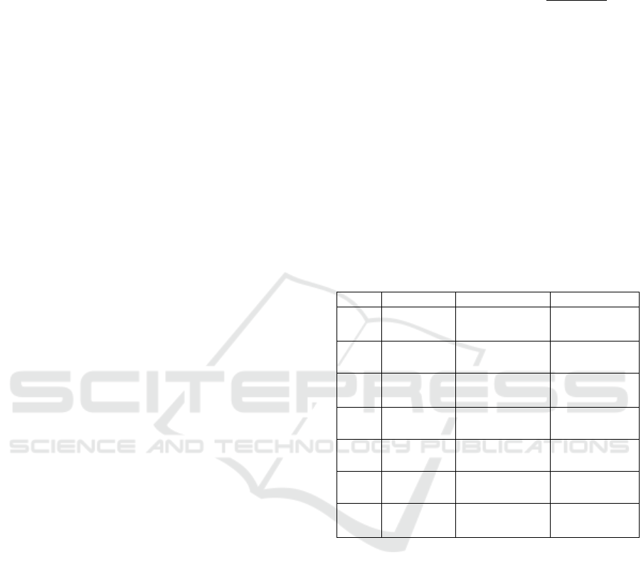
constructed (Table 1).
Table 1: The coordination characteristics between the
arable land resources change and urbanization level.
Level
C
mn
m,n T
yp
e
Ⅰ
C
mn
=
1.414
m = n and m>
0, n>0
Coordinated
Ⅱ
1.2 ≤C
mn
<
1.414
m≈n
More
coordinated
Ⅲ
1.0 ≤C
mn
<
1.2
m>0, n<0
and m>n
Basic
coordination
Ⅳ
0.8 ≤C
mn
<
1.0
m>0, n<0 Harmonious
Ⅴ
0.5 ≤C
mn
<
0.8
m>0, n<0
Harmonized
Ⅵ
0 ≤C
mn
<
0.5
m>0, n<0
Barely
harmonized
Ⅶ
-1.414
≤C
mn
< 0
m>0, n<0 or
m<0, n<0
Not in tune
3 RESULTS AND ANALYSIS
3.1 Dynamics of Urbanization
Development
During the study period, Meizhou City demonstrated
relatively moderate fluctuations in its level of
urbanization compared to other cities in the province,
yet it consistently exhibited an upward trend (Figure
1). The urbanization level in Meizhou City increased
from 23.25% at the beginning of the study period to
48.09% at the end, representing a substantial growth
of 24.84% with an average annual increase of 0.83%.
Specifically, the proportion of the urban population
rose from 14.37% to 40.18%, indicating a remarkable
Analysis of the Coordinated Development Mechanism Between Urbanization and Arable Land Resource Quantity Changes in
Underdeveloped Mountainous Areas: A Case Study of Meizhou City
153
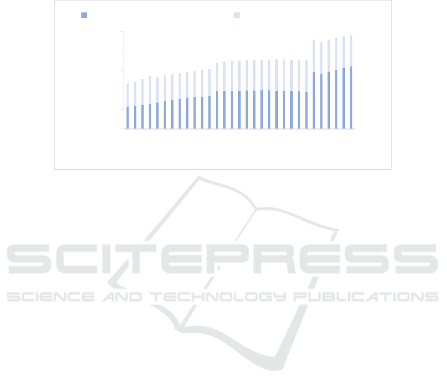
increase of 25.91% with an average annual growth of
0.86%. Moreover, the proportion of non-farm GDP
(i.e., the contribution of the secondary and tertiary
sectors to the total GDP) experienced a significant
rise from 58.75% to 79.72%, reflecting an impressive
increase of 20.97% with an average annual growth of
0.70%.
Figure 1: The urbanization level changed status.
3.2 Development of Arable Land
Resources
During the study period, the amount of arable land
resources in Meizhou City exhibited distinct patterns
divided into three phases (
Figure 2), characterized by
relatively stable and minor changes compared to other
cities in the province. The first phase, spanning from
1990 to 1999, displayed a downward trend as the
arable land area decreased from 1415.00 km
2
in 1990
to 1346.66 km
2
in 1999, resulting in a decline of 68.34
km
2
with an average annual decrease of 7.59 km
2
. The
second phase, covering the period from 2000 to 2020,
witnessed a significant surge in arable land resources
due to the adoption of a new statistical method for
assessing arable land area in various cities across
Guangdong Province. In 2000, the arable land area
reached a peak of 1665.29 km
2
. Subsequently, the
amount of arable land resources in Meizhou City
continued to experience a gradual upward trend,
reaching 1682.66 km
2
in 2005. Within this phase, the
increment amounted to 9.31 km
2
, with an average
annual increase of 1.86 km
2
. The third phase, from
2006 to 2020, mirrored the characteristics of the first
phase, displaying a gently declining trend as the
arable land area decreased from 1675.45 km
2
to
1611.53 km
2
. Consequently, the arable land resources
witnessed a reduction of 63.92 km
2
with an average
annual decrease of 4.57 km
2
. The graphical
representation reveals discernible fluctuations in the
per capita arable land area in Meizhou City from 1990
to 2020, with the lowest point of 2.83 km² per 10,000
people observed in 1999 and the highest point of 3.43
km² per 10,000 people recorded in 2000.
3.3 Analysis of the Relationship
between Urbanization Level and
Changes in Arable Land Resources
3.3.1 Changes in Urbanization Level and
Amount of Arable Land Resources
During the period from 1990 to 2020, Meizhou City
experienced notable fluctuations in the quantity of
arable land and the level of urbanization. The study
period witnessed a substantial variation in arable land,
with a change in the quantity of 196.53 km
2
,
corresponding to an annual change rate of 6.55 km
2
,
reflecting intensity of change of 13.89% and a
dynamic attitude of 0.46%. The urbanization level
exhibited a rise of 24.85% and an average annual
growth rate of 0.83%. Furthermore, the urbanization
occupancy factor in Meizhou City between 1990 and
2020 was determined as 7.91 km
2
, indicating that
each one-percentage-point increase in the
urbanization level necessitated the utilization of 7.91
km
2
of arable land resources (Table 2). The findings
from Table 2 underscore the significant changes in
both arable land and urbanization levels during the
period from 1990 to 2020, aligning with China's "8th
Five-Year Plan" to "13th Five-Year Plan" periods.
0.00%
10.00%
20.00%
30.00%
40.00%
50.00%
1990
1992
1994
1996
1998
2000
2002
2004
2006
2008
2010
2012
2014
2016
2018
2020
Urbanization level(%)
Proportion of urban population Proportion of non-farm GDP
ICESCE 2024 - The International Conference on Environmental Science and Civil Engineering
154
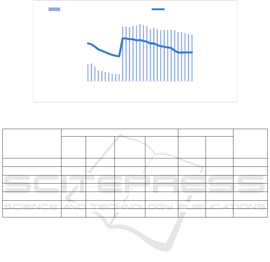
Figure 2: The arable land amount changed status.
Table 2: The Arable Land amount change status and urbanization evolution process.
Amount of arable land resources Urbanization level
UOF* (km
2
)
Changes
(km
2
)
Speed of
change
(km
2
/year)
The
intensity of
change(%)
Change of
dynamic
attitude(%)
Changes
(%)
Average
annual
speed(%)
The 8th Five-Year Plan -56.69 -11.34 -4.00 -0.80 3.23 0.65 -17.54
The 9th Five-Year Plan 310.14 62.03 22.89 4.58 2.35 0.47 131.95
The 10th Five-Year Plan 16.37 3.27 0.98 0.20 4.21 0.84 3.89
The 11th Five-Year Plan -26.97 -5.39 -1.61 -0.32 0.42 0.08 -64.29
The 12th Five-Year Plan 0.75 0.15 0.05 0.01 10.01 2.00 0.07
The 13th Five-Year Plan -18.54 -3.71 -1.14 -0.23 3.39 0.68 -5.47
1990-2020 196.53 6.55 13.89 0.46 24.85 0.83 7.91
*Urbanization occupancy factor:The amount of arable land resources occupied in the process of urbanization.
3.3.2 Correlation between Urbanization
Level and Amount of Arable Land
Resources
To examine the coherence between the urbanization
level and the amount of arable land resources in
Meizhou City, a correlation analysis was conducted
using the SPSS software, and a fitted curve graph was
generated (
Figure 3). The analysis revealed a
correlation coefficient of 0.4121, indicating a
moderate correlation between the urbanization level
and the amount of arable land resources in Meizhou
City. This finding highlights the need for further
quantitative analysis to delve deeper into the
relationship between these two factors.
3.3.3 Coherence between Urbanization
Level and Amount of Arable Land
Resources
From 1990 to 2020, Meizhou City witnessed
significant fluctuations in the coherence between its
urbanization level and the amount of arable land
resources, displaying a pronounced tendency towards
concentration. During the study period, 10 years
exhibited a state of "Harmonized" or higher (C
mn
≥
0.8), accounting for approximately 33.33% of the
total years analyzed. Among these, 5 years (1991,
2003, 2004, 2005, 2014) were categorized as "More
coordinated" (1.2≤C
mn
<1.414), and 3 years (2000,
2001, 2009) were classified as "Basically
coordinated" (1.0≤C
mn
<1.2). The remaining 2 years
(2002, 2015) fell into the "Harmonized" category (0.8
≤ C
mn
< 1.0). Moreover, within the 12 years
classified as "Not in tune" (C
mn
< 0), a strong
2.00
3.00
4.00
1300.00
1400.00
1500.00
1600.00
1700.00
1990
1993
1996
1999
2002
2005
2008
2011
2014
2017
2020
Arable land per capita
(10
-4
km²/per)
Amount of arable land
resources (km²)
Amount of arable land resources Arable land per capita
Analysis of the Coordinated Development Mechanism Between Urbanization and Arable Land Resource Quantity Changes in
Underdeveloped Mountainous Areas: A Case Study of Meizhou City
155
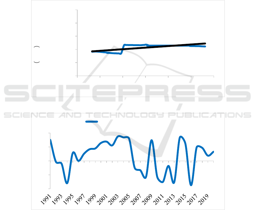
continuous trend was observed during the periods of
1992-1996 and 2006-2013. In the remaining years, 3
years were deemed "Barely harmonized" (0≤C
mn
<
0.5), while 5 years were considered "Basically
harmonized" (0.5 ≤ C
mn
< 0.8). Overall, Meizhou
City exhibited a relatively high coherence level in the
early stages of the study period, followed by
increased fluctuations and a distinctive pattern of
periodic variations, reflecting a strong phase-
aggregated characteristic (Figure 4).
By employing the coherence evaluation model for the
urbanization level and the amount of arable land resources,
a comprehensive calculation and analysis of the
coherence level between the urbanization level and the
amount of arable land resources in Meizhou City from
1990 to 2020 were conducted, resulting in the coherence
variation curve. The analysis indicates that as the
urbanization process accelerates, the coherence between
the urbanization level and the amount of arable land
resources in Meizhou City experiences more frequent
fluctuations, highlighting the urgent need for more
comprehensive measures to promote their coordinated
development.
Figure 3: The fitting curve of the Arable Land change and urbanization.
Figure 4: The coordination degree between the Arable land amount change and urbanization level.
4 CONCLUSIONS AND
RECOMMENDATIONS
Based on the comprehensive analysis conducted, it is
evident that the accelerated pace of urbanization in
Meizhou City has intensified the conflict between
urban development and the preservation of arable
land resources, leading to a significant supply-
demand imbalance. To address these challenges
effectively, the following recommendations are
proposed:
y = 1200.5x + 1146.8
R² = 0.4121
500.00
1000.00
1500.00
2000.00
2500.00
3000.00
20% 25% 30% 35% 40% 45% 50%
Amount of arable land
resources
km²
Urbanization level(%)
-1.6
-0.8
0
0.8
1.6
Meizhou coordination degree
ICESCE 2024 - The International Conference on Environmental Science and Civil Engineering
156

a) Emphasize Sustainable Development: Meizhou
City should prioritize sustainable approaches in
urbanization endeavors, focusing on environmentally
friendly practices and strategies. This includes
promoting the optimization of construction land
resources and encouraging their efficient and
responsible use.
b) Enhance Land Intensity and Resource
Efficiency: Measures should be taken to improve the
intensity and efficiency of land utilization in Meizhou
City. This can be achieved through the refinement and
strict implementation of land-use standards,
particularly for industrial land, along with effective
management and planning practices.
c) Encourage Intensive Land Use Policies:
Meizhou City should formulate and implement
policies that incentivize and support the intensive use
of land resources. This can involve providing
incentives for enterprises to revitalize existing
construction land resources and actively engage in
sustainable land utilization practices.
d) Strengthen Land-Use Regulations: Rigorous
enforcement of land-use regulations is essential to
protect arable land in Meizhou City. It is imperative
to establish and refine a comprehensive legal
framework for land utilization, ensuring strict
adherence to land-use purposes and the
implementation of necessary safeguards to protect
arable land.
e) Implement Dynamic Land Monitoring: Regular
monitoring of land-use patterns is crucial for
identifying and addressing issues such as inefficient
land use and underutilization. Meizhou City should
establish a robust system for dynamic land
monitoring to detect and prevent such occurrences.
In summary, Meizhou City must prioritize
sustainable and responsible urban development
practices to effectively manage the conflict between
urbanization and the preservation of arable land
resources. By embracing sustainable development
principles, optimizing land allocation, promoting
efficient land use, and enforcing strict land-use
regulations, Meizhou City can successfully tackle
these challenges and achieve a harmonious balance
between urbanization and the preservation of arable
land resources.
REFERENCES
Zhan, J. 2014. Research on the coordinated development of
urbanization and farmland protection in the perspective
of ecological civilization -- taking Ningde City, Fujian
Province as an example. China's Agricultural
Resources and Regionalization, 35 (4): 13-19.
He, L., Li, W., Tian, S., et al. 2018. The impact of rapid
urbanization in the Yangtze River Economic Belt on
farmland protection. Journal of Ecology, 38 (21): 7782-
7789.
Cheng, X., Gao, G., Liu, Q., Tao, Y., Huang, C., Ou, W.
2022. Spatial pattern, impact mechanism and
governance path of cultivated land abandonment in
rapid urbanization areas. Journal of Agricultural
Engineering, 38 (24): 218-227.
Chan, S., Jiang, H., Yuan, X., Zhao, Y. 2023. Spatial
temporal analysis of coupling and coordination of
urbanization and Ecological efficiency of cultivated
land use in Shaanxi Province. Research on Water and
Soil Conservation, 30 (04): 338-346.
Liu, C., Wang, Y., Cao, J. 2022. The impact of urbanization
on the utilization efficiency of arable land in grain
producing areas. Agricultural Modernization Research,
43 (05): 803-813.
Zhao, X., Liu, B., Ding, Y., Zeng, W., Zou, J., Liu, G. 2023.
Measurement of the Coordination Degree between
Urbanization Level and Cultivated Land Resource
Change: Taking Guangdong Province as an Example.
Industry and Technology Forum, 22 (03): 35-38.
Zhang, Y. 2019. Research on optimal allocation of water
and soil resources for cultivated land use in Naoli River
Basin. Northeastern University, Shenyang.
Liang, H., Yan, S., Li, H. 2019. Study on the spatiotemporal
coupling relationship between urbanization and arable
land resources in China: based on data from 2001 to
2016. Journal of Hubei University of Economics, 17
(04): 79-89.
Yu, G. 2019. Research on evaluation of comprehensive
carrying capacity of water and soil resources in
Shandong Province from the perspective of human land
coordination. Shandong Normal University, Jinan.
Xu, Y., Yi, Y., Fang, X., Zhao, X., Liu, G. 2023. A
comparative study on the coordination between the
urbanization level of Resource depletion and the
changes in the quantity of cultivated land resources --
Taking Shaoguan, Guangdong Province as an example.
China's Comprehensive Utilization of Resources, 41
(03): 52-57.
Analysis of the Coordinated Development Mechanism Between Urbanization and Arable Land Resource Quantity Changes in
Underdeveloped Mountainous Areas: A Case Study of Meizhou City
157
