
Ethnicity, Urbanisation and Crimes in Malaysia: Sociological and
GIS Transborder Analyses of a Social Conflict
Nur Suhaili Mansor
1
a
, Afriva Khaidir
2
b
, Arie Yulfa
2
c
Mohd Sobhi Ishak
3
d
,
Mansor Mohd Noor
3
e
and Suryanef
2
f
1
Universiti Utara Malaysia, Malaysia
2
Universitas Negeri Padang, Indonesia
3
Universitas Kebangsaan Malaysia, Malaysia
Keywords: Ethnic Group, Urban Development, Crimes and Social Conflict.
Abstract: This study aims to explore social phenomena from the perspective of scientific and technological knowledge.
Information on urban development and its relationship with crime and conflict in a multi-ethnic urban setting
is collected through a social survey, narcotics and crime records from the police, and the GIS on the
development of the township of Sungai Petani. Surveys show that urban development is socially organized
and that the Chinese community benefits more significantly than Malays and Indians from urban growth. The
data on urban development reflect the fact that as both development and urban areas are growing, Malays
living in rural areas and Indians on rubber estates are dislocated, thereby joining the urban poor with limited
education, income, and job skills. The narcotic and crime data collected were superimposed on the GIS data
of Sungai Petani, Malaysia. Drug-related crime patterns were observed to be related to the expansion of
industrial and housing schemes. This situation, if not identified and managed, often ends in ethnic conflict. It
happened in 2012, these ethnic groups of development losers, street bikers and gangsters fought across ethnic
lines.
1 INTRODUCTION
Development, industrialisation, technological change
and internal as well as external migration within
Malaysia since the 1970s have transformed the
landscape, especially of Peninsular Malaysia into
cosmopolitan and urbanized society. Local Agenda
21 was introduced into the local governments
throughout the country in managing the urban, town
and city. The urban development agenda have
prioritised societal well-being and security of the
urban inhabitant in the urban planning and
implementation by the local governments in
Malaysia. The local governments are supported by
other agencies such as the Police, Welfare, Fire and
Rescue, Health, National Unity and, including
community and civil society to ensure that the urban
development goals defined will be achieved.
Yet in situations of drastic development,
urbanization, social changes and transformation,
development failures and social inequalities that
overlap over ethnic and religious lines in a diverse
society, not only produce social problems and crimes
but ethnoreligious skirmishes that eventually might
lead to ethnic conflict (Noor 2000). There is indeed a
correlation between crime, urban growth, and social
mobility among various ethnic groups (Noor and
Mansor 2017). In Malaysia, these societal
dysfunctions of ethnic skirmishes have erupted in
Kampung Medan, Kampung Rawa, Taiping, Pasir
Gudang and, among others in Sungai Petani. GIS-
based
analysis is able to determine conflict hotspot
a
https://orcid.org/0000-0002-7780-3691
b
https://orcid.org/0000-0003-1565-5133
c
https://orcid.org/0000-0002-5319-8749
d
https://orcid.org/0000-0003-1516-5652
e
https://orcid.org/0000-0002-8207-6409
f
https://orcid.org/0000-0001-6109-7246
Mansor, N. S., Khaidir, A., Yulfa, A., Ishak, M. S., Noor, M. M. and Suryanef,
Ethnicity, Urbanisation and Crimes in Malaysia: Sociological and GIS Transborder Analyses of a Social Conflict.
DOI: 10.5220/0013414100004654
In Proceedings of the 4th International Conference on Humanities Education, Law, and Social Science (ICHELS 2024), pages 253-261
ISBN: 978-989-758-752-8
Copyright © 2025 by Paper published under CC license (CC BY-NC-ND 4.0)
253
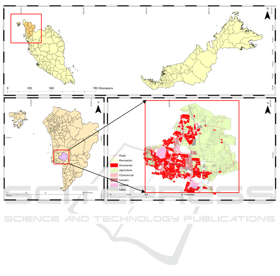
Figure 1: Study area at Sungai Petani, Kedah.
zones to describe how the conflict is spatially located
(Tadesse 2023).
1.1 The Ethnic Skirmishes in Sungai
Petani, Kedah
The township of Sungai Petani is located in the
northern part of Kedah. (see
Figure
1). Since the 1990s
industries from Penang over-spilled into the Sungai
Petani area, bringing in development and saw urban
spatial growth of its town area into the traditional
Malay villages and the rubber estates on the foothill
as new industrial sites, housing schemes and urban
centers were built. However, the urbanization taking
place that has encroached on the Malay kampong and
rubber estates have pushed the Malays and Indians to
migrate to the urban areas and become the indigent
urban poor there. The displaced groups of Malay and
Indian have low level of education, unskilled
occupation and low income. Thus, their migration to
the urban center continued their structural inter-
generational vicious circle of poverty that was
inherited from their great grand-fathers (Mapjabil,
Yusof, and Jusoh 2010).
On Sunday, 16 December 2012 group fighting
between Malay and Indian youths over
misunderstanding among the ethnic street-bikers in
the previous night in Sungai Petani. Illegal motorbike
street race among youth and gangsterism were the
catalysts for the incident. The skirmishes took place
in the low-income public housing scheme that housed
the relocated Indian and Malay communities that
were occupying on the river reserve land that pass
through the town. However, interviews with the local
leaders, government agencies and the community
show that those involved in the incident are the
victims of development losers that trapped them in
inter-generational poverty.
1.2 Research Objective
The focuses of this article are to identify and explain
the individual and urban security from social class
perspective, the roles governance in the social
problems, crimes, the individual and urban security
ICHELS 2024 - The International Conference on Humanities Education, Law, and Social Science
254
and action plans to manage the social tension for
future peace and national unity. This sociological
study was also supported by concurrent research of
the changing pattern of the urban land-use and its
relationship to crimes involving petty thefts, property
thefts and drugs.
With such focuses of study, the hypotheses are
that urban and individual security have a direct
influence by social problems and crimes, social
problems and crimes by urban governance and urban
governance has an indirect influence on urban and
individual security. While the patterns of land-use is
to measure the rate of urban development and its
relationship to crime. This trans-border study of
combining the socio-logical perspective and science
and technological approach using GIS in identifying
and explaining physical, economic and social
development could be better used in studying the
dynamic of social phenomenon and social changes in
the society.
2 RESEARCH METHODOLOGY
The research design is quantitative and a
questionnaire was used to collect primary data. A
total sample of 444 respondents were interviewed and
by ethnic groups, 217 were Malays, 145 Indians and
82 Chinese. The areas studied in Sungai Petani
Munici-pality were Taman Ria Jaya, Flat Paya Nahu,
Flat Paya Nahu 1, Taman Keladi, Taman Ria, and
Taman Petani Jaya.
The instrument of urban security has 6 items with
a five scale of agree to disagree and the reliability
composite is CR=0.586. While the individual security
has 13 has 13 items, with five scale and reliability
composite is CR=0.841. In the prediction variables,
the social problem instrument has 5 items and
CR=0.920 and the crime instrument has 5 items and
CR=0.863. And both these instruments used a scale
from 1 very bad to 10 very good. The governance and
development instrument has a five scale of agreement
with CR=0.877). In analysing the causal predictive
variable (β), the changes to the main variable (R
2
) and
the impact of the predictive variable (f
2
).
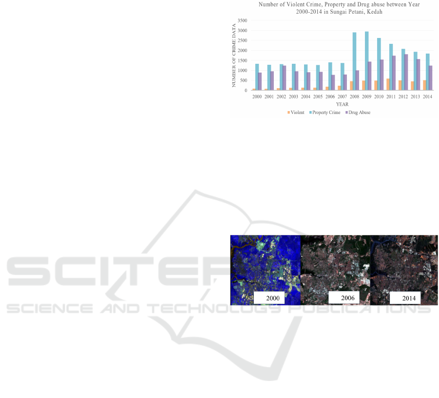
Primary data related to crime cases (
Figure
2) is
obtained from the crime record at the Royal
Malaysian Police, Sungai Petani, Kedah. The
researchers obtained information on crimes within the
period of 2000 to 2014 from Kuala Muda Police
Department covering, among others, violent crimes,
property crimes, and drug-related cases. Such data,
stored in an information system, can be analyzed
based on the overall statistics on crime cases, crime
rates, types of crimes, the geographical distribution of
crimes, and the characteristics of crimes.
Figure 2: Total Number of Crime Data from 2000 to 2014.
The satellite imagery data (
Figure
3) was obtained
from the Malaysian Space Agency (MySA) and the
Sungai Petani authority, Kedah. Both these primer
data of crime and land-use patterns were collected
from 2000 to 2013. Studies do show that urban
growth, over time, can also change the potential for
crime (Felson 1987).
Figure 3: SPOT-5 Satellite Imagery Year 2000, 2006 and
2013 for Sungai Petani.
3 RESULTS AND DISCUSSIONS
3.1 Results
The predictive variables of urban governance, social
problems and crimes predicted urban security along
the low social status at 20.0 percent and middle social
status at 22.2 percent. While the same predictive
variables of urban governance, social problems and
crimes predicted individual security at 6.8 percent
among the low social status and middle social status
at 18.4 percent.
Among the low social status respondents, crime at
36.6 percent has a direct relationship with urban
security. While among the middle social status, social
problem at 35.8 percent shows a direct impact on
individual security. Both social status show that
governance and development at 16.7 percent and 19.7
percent, respectively, registered an indirect
Ethnicity, Urbanisation and Crimes in Malaysia: Sociological and GIS Transborder Analyses of a Social Conflict
255
relationship with urban security. Middle social status,
at 17.6 percent, has an indirect relationship with
individual security.
Analysing the instrument of social problem, the
low social status at 59.8 percent and middle social
status at 65.9 percent have a dominant influence on
crime with low social status at 45.3 percent and
middle social status with 49.9 percent. However, the
governance and development instruments show to
have a dominant influence on social problems, crime
and urban security.
A strong discovery of this study is the fact that
social problems are a major predictor of criminal
behavior. The major inference from this is that such
issues have a strong impact on people of both low and
middle social classes. As such, this study establishes
that governance and development of individuals from
lower social strata are of paramount importance and
must be informed by planning based on empirical
evidence to prevent social problems, minimize
criminal activities, and improve urban safety in the
study
area. In this regard, it is important to note that
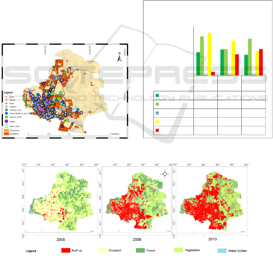
Figure 4: Crime Distribution in Sungai Petani from Year
2000-2013.
ethnic and religious differences do not form the basis
of causes of conflicts witnessed in Sungai Petani.
In line with the above, the GIS analysis of the
relationship between urban growth and crime using
Spearman's rank-order correlation approach was
conducted to test the relation of overall crime with
urban land; the preliminary data examined via visual
inspection of a scatterplot showed that the relation
was not exactly monotonic. Although the linear
equation shows slight positive relation, yet result is
not statistically significant at r= 0.059> 0.05, since it
fails to reject, hence there is no significant
association. However, in a Precise analysis of Violent
Crime Related to Urban Growth in Sg. Petani That
shows strong positive correlation on the Spearman
correlation
co-efficient (=0.833). The increase in
Figure 5: Landuse Changes in Sungai Petani Year 2000,
2006 and 2013.
Figure 6: Landuse Changes in Sungai Petani Year 2000, 2006 and 2013.
Year
2000
Year
2006
Year
2013
Forest
21.4 23.8 19.0
Vegetation
35.8 24.1 33.7
Water bodies
0.6 0.8 0.9
Cropland
39.1 31.9 22.2
Built up
3.1 19.4 24.2
0.0
5.0
10.0
15.0
20.0
25.0
30.0
35.0
40.0
45.0
Area m
2
(%)
Land Use Changes in Sungai Petani
Year 2000, 2006 and 2013
ICHELS 2024 - The International Conference on Humanities Education, Law, and Social Science
256
urban areas over the same period manifested a strong
relationship with the recorded rise in general criminal
activities, rs(8) = 0.833, p < 0.05. Additionally, a
Spearman's rank-order correlation test was conducted
to ascertain the strength of the relationship between
urban growth over the period and the level of crime
in Sungai Petani. The analysis showed a positive
relation between urban growth and the prevalence of
drug abuse, rs(8) = 0.587, p < 0.05. However, the
relationship between urban growth and violent crime
is not significant in the scope of this research.
The increase in total crime recorded over the
period under study was found to have a positive and
significant relationship with the increase in
urbanization, rs(8) = 0.833, p < 0.05. Further,
Spearman's rank-order correlation was carried out to
assess the nature and strength of the relationship
between
urban development over the stated period
Figure 7: Course of Crime Occurrences in Sungai Petani for the Year 2000-2013.
Ethnicity, Urbanisation and Crimes in Malaysia: Sociological and GIS Transborder Analyses of a Social Conflict
257
and the prevalence of criminal activities in Sungai
Petani. Urban growth was positively correlated with
the rate of drug abuse, rs(8) = 0.587, p < 0.05.
However, urban growth and violence crime is not
significance in this study.
The types of crime distribution in Sungai Petani
are drugs, murder, rape, robbery, house damage,
vehicle theft, mugging and others in 2000 – 2013
(
Figure 4). These crimes occurred in commercial and
residential areas. Most of the crime that occurs is
southwest of Sungai Petani area.
On Figure 5 it illustrates the variations in land use
between 2000, 2006, and 2013, showing a rapid
growth in built-up areas from 3.1% to 24.2%. Figure
6 provides a visual analysis of urban development,
with water bodies in blue, forests in dark green,
vegetation in light green, cropland in yellow, and
built-up areas in red. The data indicates a significant
rise in urban growth and population during this
period. The findings from the sociological and GIS
approaches show that urban growth affects social
problems and crime, which negatively impacts
individual and urban security.
The analysis depicted in Figure 7 reveals the
movement patterns of criminal activity from 2000 to
2013,
differing from previous results. The study
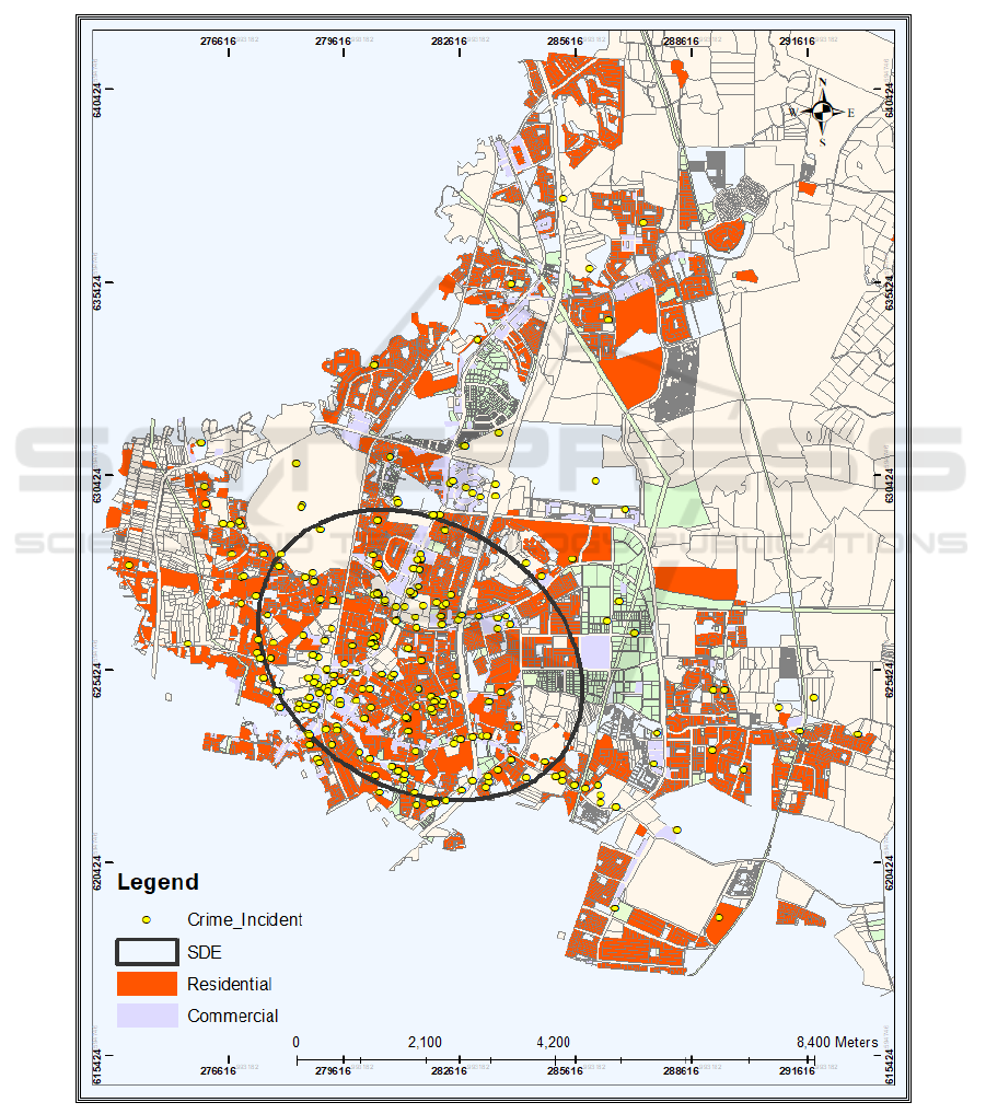
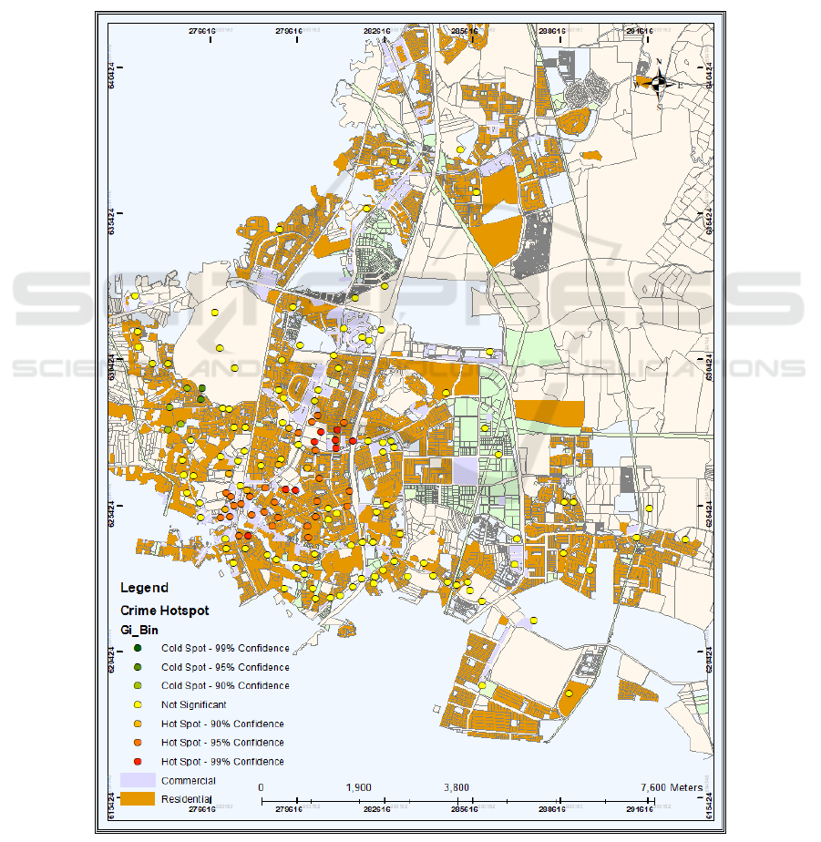
Figure 8: Hotspot of Criminal Activities in Sungai Petani.
ICHELS 2024 - The International Conference on Humanities Education, Law, and Social Science
258

suggests that the physical structure of areas can
influence criminal behaviour. The map indicates that
criminal activities are increasingly distributed
towards Kulim and Penang, known as industrial
cities.
The Hotspot analysis was carried out to
determine the spatial distribution of crime activities
that occurred between the years 2000 and 2013 using
Euclidean distance for accurate measurement. The
research resulted in a z-score for each value, which
represents the statistical significance of the spatial
clustering based on the randomization null
hypothesis. The findings indicate that most crime
hotspots, particularly those in commercial and
industrial regions are located in Sungai Petani. To
represent the density of crime, a map using graduated
colors was made, in which green shows low z-scores
and yellow and red show moderate and high z-scores,
respectively, thus showing areas with the highest
crime rates.
Figure 8 shows these crime hotspots, with
the red areas representing high crime rates standing
out in Sungai Petani.
3.2 Discussions
The study shows that the social location of an
individual, group and community do have strong
relationship on social problem and crime experienced
and its impact on individual and urban security as
well their access to urban governance and
development. Even though the incident of ethnic
skirmishes in Sungai Petani did involve the ethnic
Malay and Indian groups but the data collected did
not give evidence that ethnic and religious differences
as the cause to skirmishes taking place among these
groups (Noor 2021).
The main causes highlight the failures of urban
governance of security and the redistribution of the
fruits of development fairly and inclusively,
especially to low social status group. Thus, social
problem and crime in urban area being studied are
related to urban planning and implementation of the
local development plan and, may be relevance to the
hot spot of ethnic skirmishes in other urban centres in
Malaysia (Browning et al. 2010).
Analysing the data by social status grouping do
show that social problems and crime are observed to
have negative impact on the family and life of the
majority of the low social status group (Mansor et al.
2014). Urban governance and development failures
that give rise to the social problem in the communities
are the causes to the rising level of criminal activities
that will influence negatively on urban security.
Despite the above findings, the low social status
group studied still views positively and recognises the
roles of governance by the local government in
managing to reduce the social problem and crime in
their areas. In fact, without effective intervention by
the local government, other state and federal agencies
as well as the NGO, they do anticipate that the
security of their family and housing areas in their
urban setting will be more negatively affected.
Among the middle social status group, they foresee
the initial factor of social problem and urban
governance and development failures that generate
the rising level of crime in their housing areas.
The variations between these social status groups
could be identified in which the middle social status
group place individual security compared to the low
social status group. To the middle social status group,
personal and family matters are importance to them
over others. This prevails as fundamental needs from
security is being con-trolled with care. Yet the group
does inform that, generally, urban governance and
development are still regarded as importance to
ensure their individual security.
The GIS and crime data do support the
sociological study that social location does influence
behaviour of the urban dwellers. The 2000 to 2013
data on changing pattern of land use and crime
including narcotic collected show that where the low
social status group stays, social problem, petty crime
and drugs overlap with social status and crime. While
in the middle social status housing scheme, property
crime is low as often theirs are a gated-community.
The study on the relationship between pattern of land
use and crime in Sungai Petani should be a
comparative study of other township and city in
Malaysia in order to measure the strength and
significance of their relationship.
3.3 Way Forward in Managing Urban
Skirmishes
These findings have contributed to the literature,
informed practical applications, and influenced
policy-making in the context of urban growth and
overall well-being. The information added from this
study will also contribute to the strategic planning of
future urban redevelopments that consider all
essential factors, particularly societal well-being, in
an attempt to increase the liveability of our cities. The
most important contribution that this study makes is
in its methodology, since it combines capabilities of
the social sciences with spatial analysts using GIS in
detecting and describing the social phenomena being
studied. This research has confirmed that the
disciplines of science and technology combined with
Ethnicity, Urbanisation and Crimes in Malaysia: Sociological and GIS Transborder Analyses of a Social Conflict
259

that of the social sciences would be able to support
our remark of the society together with the power to
explain challenges faced.
Social problems, criminal activities, and social
conflicts are linked to issues of rapid urban
development, industrialization, and uneven
development within urban and suburban areas. The
social consequences are proven through information
obtained from GIS, crime statistics, and social
surveys that demonstrate all communities in the area
are affected; this negatively hampers the realization
of sustainable development objectives set for the
areas (Tadesse 2023).
Planning for urban governance and development
of Sungai Petani must be given priority in managing
the social problem in eradicating crime so as to
enhance the level of individual and urban security in
the community (Jayasooria 2008). Intervention
through com-munity development among the B40
group should be given greater emphasised. Among
the initiatives can be planned for them are an
educational intervention among the children of the
B40 group be given in their community so as to
strengthen their educational achievement from the
kindergarten, primary school to the working world.
Training job skills should be made available to their
children who finish schooling and, especially the
drop-out from the schooling system, in ensuring they
be employable. Training social skills of life such as
parenting, educational culture and home science be
made available to the parents of the B40 group. At the
community level, community-based self-help group
and security patrol of their neighbourhood should be
encouraged as their responsibility. Non-
governmental Organisations and government
agencies should provide institutional and leadership
support to the local community in ensuring national
unity, public security and prosperity in the housing
areas be attained.
4 CONCLUSION
Urbanization is a universal phenomenon. Besides,
urbanization is directly linked to industrialization.
Industrialization is the major impetus to economic
growth that fosters modernization and contemporary
development in backward countries like Malaysia.
Still, even as modernization brings many benefits, it
also leads to problems of social stratification and
marginalization which come with the said
development.
Unplanned development and urbanization have
brought about unintended side effects of political
instability and ethnic conflicts among the bottom
fourty percent and the slum dwellers in Malaysia.
Although ethnicity is unlikely to be the direct cause
of tension and skirmish among a nation, how poorer
urban individuals develop within post-colonial
pluralistic societies may result in ethnic-group
competition for access to a nation's resources and
social attention that can sharpen ethnic divisions and
social inequality.
ACKNOWLEDGEMENTS
We wish to express our deepest gratitude to all parties
who have contributed to the success of this project.
This endeavour embodies a spirit of collaboration,
learning, and mutual support among three esteemed
universities: Universiti Utara Malaysia, Universitas
Kebangsaan Malaysia, and Universitas Negeri
Padang, Indonesia. Together, we have produced a
project of which we are truly proud.
REFERENCES
Browning, Christopher R., Reginald A. Byron, Catherine
A. Calder, Lauren J. Krivo, Mei-Po Kwan, Jae-Yong
Lee, and Ruth D. Peterson. 2010. “Commercial
Density, Residential Concentration, and Crime: Land
Use Patterns and Violence in Neighborhood Context.”
Journal of Research in Crime and Delinquency
47(3):329–57.
Felson, Marcus. 1987. “Routine Activities and Crime
Prevention in the Developing Metropolis.”
Criminology 25(4):911–32.
Jayasooria, Denison. 2008. Social Development & Indians
in Malaysia: An Agenda for Social Inclusion. Yayasan
Strategik Sosial.
Mansor, Nur Suhaili, Helmi Zulhaidi Mohd Shafri, Shattri
Mansor, and Biswajeet Paradhan. 2014. “The Influence
of Urban Development and Social Mobility on
Socioeconomic Level: The Application of GIS on
Urban Ecosystems.” Pp. 12011–12011 in IOP
Conference Series: Earth and Environmental Science.
Vol. 20. IOP Publishing.
Mapjabil, Jabil, Nooriah Yusof, and Ahmad Tharmizzie
Mat Jusoh. 2010. “Transformasi Pembangunan
Ekonomi Di Negeri Kedah : Perspektif Historikal.”
Universiti Kebangsaan Malaysia 2:11–11.
Noor, Mansor Mohd. 2000. Social Conflicts in Indonesia
and Malaysia: Could the Cause Be Religious?
Noor, Mansor Mohd. 2021. Changing Ethnic Boundary,
Social Differentiation and the Malaysian Nation: Roots
of Malaysian Stability. Penerbit Universiti Kebangsaan
Malaysia.
Noor, Mansor Mohd, and Nur Suhaili Mansor. 2017.
“Ethnicity, Development, Crimes and Conflict in a
ICHELS 2024 - The International Conference on Humanities Education, Law, and Social Science
260

Multi-Ethnic Urban Setting in Malaysia: Trans-Border
Sociological and GIS Analyses of an Urban Society.”
WIT Transactions on Ecology and the Environment
226:359–67. doi: 10.2495/SDP170311.
Tadesse, Habte. 2023. “Modelling Conflict Dynamics:
Evidence from Africa: What Do the Data Show via
Spatiotemporal Global ACLED Dataset?” Applied
Spatial Analysis and Policy 16(4):1541–59. doi:
10.1007/s12061-023-09522-1.
Ethnicity, Urbanisation and Crimes in Malaysia: Sociological and GIS Transborder Analyses of a Social Conflict
261
