
Becoming a Resilient Community Fighting the Drought Disaster
Ratna Wilis
1
, Dedi Hermon
1
, Helfia Edial
1
, Abel Tasman
2
and Aldri Frinaldi
1
1
Department of Geography, Faculty of Social Sciences, Padang State University, Indonesia
2
Department of Public Administration, Faculty of Social Sciences, Padang State University, Indonesia
Keywords: Disaster, Drought, Food Agriculture, Productivity.
Abstract: Several areas in Tanah Datar Regency, including Rangkat and Lima Kaum Districts, are beginning to
experience drought, threatening crop failure due to the extreme heat. This situation is further aggravated by
the Galodo disaster that occurred in 2024. The purpose of this study is to transform Lima Kaum Village into
a community resilient to drought disasters. The methods employed include counseling, training, workshops,
and field practice assistance. The outcomes of the study are as follows: 1) an increase in community
knowledge and skills to effectively address drought disasters, 2) improved understanding and skills in
maintaining and restoring the fertility of rice fields, particularly after the Galodo disaster, 3) enhanced
knowledge in managing planting patterns to adapt to the unbalanced dry and rainy seasons, and 4) an increase
in farmers' knowledge of producing eco-enzyme as a sustainable solution for improving agricultural
productivity.
1 INTRODUCTION
Global warming due to increasing concentrations of
greenhouse gases (GHG) in the atmosphere has
caused climate change. Changes in rainfall patterns,
seasonal shifts, increasing temperatures, and rising
sea levels that are currently occurring have impacted
various sectors and human life. Crop failures due to
extreme climate events are increasingly frequent and
widespread. Water availability is also decreasing
because the dry season tends to be drier. The
explosion of pest/disease cases in plants and humans
also tends to increase which is thought to be related
to global warming and climate change (Ministry of
Environment 2015). Drought is one of the natural
disasters caused by uneven distribution of rainwater,
which causes the volume of surface water such as
rivers, lakes, reservoirs, and others in several areas in
Indonesia to fall below the minimum threshold or
even due to prolonged drought which causes
depletion of groundwater reserves due to evaporation
and transpiration (Surmaini, 2016). Drought can be a
natural disaster if an area loses its source of income
due to disruption of the agricultural sector, in this case
in the form of land conversion such as rice fields.
However, it is not known for sure when this disaster
begins and ends. In general, people only realize when
the water in the well runs out, when the Regional
Drinking Water Company (PDAM) or Regional
Drinking Water Company experiences congestion,
and even when the river experiences seasonal drought
(Syamsuri, 2021).
In accordance with the RPJMD Mission of Tanah
Datar Regency and City 2021-2026 in mission 2,
namely Improving the economy of the Tanah Datar
Regency community and expanding employment
opportunities based on agriculture, industry and
MSMEs. This mission aims to realize community
welfare as described through increasing GRDP per
capita, reducing unemployment rates and increasing
the rate of economic growth by developing more
productive economic activities based on the people,
encouraging the region's leading sectors [RPJMD
Tanah Datar Regency 2021-2026 (BPPP, 2021).
Agricultural drought is defined as the lack of
groundwater availability to support the growth of
food crops and livestock from normal rainfall over a
certain period of time. This agricultural drought
occurs after symptoms of meteorological drought.
The dry season is identical to conditions of decreasing
rainfall, or rainfall below normal, so it is certain that
a number of areas experience drought.
The agricultural sector requires more than 70% of
water for consumption crops (Pratiwi, 2020). Water
is a natural resource that is very much needed by
humans. During the rainy season, water in several
44
Wilis, R., Hermon, D., Edial, H., Tasman, A. and Frinaldi, A.
Becoming a Resilient Community Fighting the Drought Disaster.
DOI: 10.5220/0013412600004654
In Proceedings of the 4th International Conference on Humanities Education, Law, and Social Science (ICHELS 2024), pages 44-50
ISBN: 978-989-758-752-8
Copyright © 2025 by Paper published under CC license (CC BY-NC-ND 4.0)

regions of Indonesia tends to be excessive and in
several regions there is a shortage of water during the
dry season (Veni, 2021). Drought disasters have a
negative impact on the agricultural sector and crop
production. Drought is a global challenge for the
world community and has occurred in all countries
(Widyastuti, 2020). Drought is basically caused by
hydrological conditions in areas with unbalanced
water conditions. Drought occurs due to uneven
distribution of rainfall. Occurs in an area. This
imbalance in rainfall causes an imbalance between
water supply and rice field production in several areas
with low rainfall. The existence of irregular changes
in seasons such as a prolonged dry season causes
drought in agricultural land, thus affecting
agricultural crop production such as decreasing
production and even experiencing crop failure (Veni,
2021).
Several areas in Tanah Datar Regency, West
Sumatra are starting to experience drought and are
threatened with crop failure due to hot weather and
damaged agricultural irrigation channels in the area,
such as areas in Tanjung Baru, Rambatan and Lima
Kaum Districts. The impact is that if this dry season
lasts a long time, around tens of hectares of rice fields
in the area will be affected by the threat of crop failure
(Faiza, 2020). Around 150 hectares of rice fields
owned by farmers in Jorong Sungai Salak, Tanjung
Oh My District, Tanah Datar Regency, West
Sumatra, experienced drought after more than a
month of no rain in the area. Most of the rice fields in
Jorong Sungai Salak are rain-fed land. Residents only
expect rainwater when they want to go to the rice
fields, if it is hot like this, they are forced to leave it
until the rainy season arrives. As a result of these
conditions, around 150 hectares of agricultural land
in the area have been abandoned. unemployed. There
are even residents' lands that have been forced to be
left unplanted for a year, because farmers cannot
force themselves to plant rice if they do not have
access to water (Rahman, 2012). The agricultural
lands owned by residents in Rambatan and Lima
Kauman Districts are now starting to turn yellow due
to not receiving water supply. In addition, the rice
fields are also cracked due to the lack of sufficient
water supply. Even though they have taken turns
channeling water to their rice fields at night with a
queuing system, it is still not enough for their rice.
Farmers in the district really hope for rain, so that the
rice plants do not die (Padang Regional Regulation,
2019).
In general, the specific problems of farmers in
Lima Kecamatan Village related to the problem of
drought are: Farmers' knowledge in saving is still
low. water during the rainy season, droughts still
often occur which cause crop failures, Farmers'
knowledge in increasing agricultural productivity is
still lacking, Farmers' knowledge in utilizing land
according to the potential and limitations of the land
is still lacking, They have not been able to develop
farming patterns to increase entrepreneurial spirit and
improve farmers' economy, and farmers' knowledge
in managing farmer group organizations is still
limited. For this reason, it is necessary to create a
disaster-resilient community. A disaster-resilient
community is a community that is responsive, trained,
steadfast and resilient to all forms of potential
disasters that occur, including drought. In accordance
with the Padang City RPJMD Mission 2019-2024 in
the 6th mission, namely to create a community that is
aware, caring and resilient to disasters. A disaster-
resilient community is a community that is
responsive, trained, steadfast and resilient to all forms
of potential disasters that occur, including drought
(BPPP, 2021). In accordance with the 2021-2026
Tanah Datar Regency RPJMD Mission in mission 2,
namely Improving the economy of the Tanah Datar
Regency community and expanding employment
opportunities based on agriculture, industry and
SMEs. This mission aims to realize community
welfare which is described through increasing GRDP
per capita, reducing unemployment rates and
increasing the rate of economic growth by developing
more productive economic activities based on the
people, encouraging the region's leading sectors
[Tanah Datar Regency RPJMD, 2021].
2 RESEARCH METHODS
This research is a qualitative research where to obtain
data must go into the field with discussions with the
community. The approach methods offered in solving
partner problems are as follows: 1) Direct discussion
with the Lima Kaum community and with village
heads and farmer groups experiencing drought, what
factors hinder the implementation of adaptation and
mitigation in dealing with this drought disaster,
preparing farmers to be resilient in saving water and
overcoming this drought, 2) Community service at
the irrigation location for their rice fields so that
tertiary channels can flow directly to their rice fields,
3) Training on adaptation and mitigation of drought
disasters, The targeted output is the birth of a
community that is aware, cares and resilient to
drought and other disasters can carry out the planting
patterns that have been prepared, 4) Training on the
use of vegetable and fruit waste for the manufacture
Becoming a Resilient Community Fighting the Drought Disaster
45
of eco-enzymes, 5) Utilization of natural materials for
the manufacture of botanical pesticides.
The most appropriate and frequently used
approach method in this study is related to training.
This training is most appropriate for activities with
this theme.
3 RESULTS AND DISCUSSION
Lima Kaum Village is a nagari with an area of 2,300
Ha and consists of 8 jorong, namely Jorong Dusun
Tuo, Koto Gadih, Balai Batu, Tigo Tumpuak, Balai
Labu Oh, Balai Labu Bawah, Kubu Rajo, and Piliang.
Its astronomical location is 100 o 28 '19" - 100 o 37'
24" East Longitude, 0 o 26' 42" - 0 o 31' 01" South
Latitude. The topography of Limo Kaum Village is at
an altitude of ± 400 M above sea level with
topographic conditions in the form of highlands and
undulating, an average temperature of 25 to 32 ° C.
Administratively, Limo Village borders 4 other
villages, namely to the north it borders Baringin
Village, to the south it borders Rambatan Nagari, to
the east it borders Beringin Nagari, and to the west it
borders Cubadak Village (BPPP, 2021). The research
location can be seen in Figure 1 below.
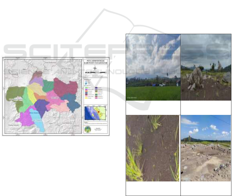
Figure 1: Research Location Map.
The results of research activities related to efforts
to realize a Drought Resilient Society are presented in
this chapter. The following will describe the
implementation of research activities that have been
carried out:
3.1 Discussion
This discussion was directly with the apparatus in
Lima Kaum sub-district regarding the disaster that
occurred, namely the galodo which buried
agricultural land in this sub-district. Farmers
experienced crop failure because the galodo disaster
first destroyed their rice fields. We discussed the form
of devotion that we could do here, especially to
restore the fertility of their agricultural land. Our team
explained that our theme was actually related to
drought, but because this area had just experienced a
galodo disaster, with the approval of the village head,
Mr. Fadhli Tarmizi SH, we hoped that we would
focus more on helping to increase the fertility of
farmers' land, especially in 2 jorong, namely Balai
Labuh Atas and Balai Labuh Bawah.
3.2 Survey Activities to Galodo
Disaster Location in Rice Fields
The research was conducted on August 12, 2024, as
well as discussions and reviews of the galodo disaster
site that had buried the community's rice fields in
Lima Kauman Village. All rice fields on the left and
right sides of Batang Malana were buried and were
confirmed to have failed harvests.
Rice Fields Before
Galodo
Land filled with rocks
and sand
Plant Remains That
Appear on the Surface
The Land is Now Flat
with the Ground
Figure 2: Condition of Rice Fields after the Galodo
Disaster.
ICHELS 2024 - The International Conference on Humanities Education, Law, and Social Science
46
The Galodo disaster that hit West Sumatra,
especially the Lima Kaum Village in Tanah Datar
Regency on May 11, 2024, has had an impact on the
loss of human lives and agricultural land as well.
Muddy rivers formed in the tributaries with wider
sizes. Several residents cried over their livestock that
were in pens that had disappeared. The green expanse
of rice fields and chili and other vegetable gardens in
several areas in Tanah Datar had turned black,
covered in mud that formed the river. Complete with
large rocks and large trees that had been cut into
pieces. Head of the Tanah Datar Communication and
Information Service Yusrizal, Monday (05/20/24) in
Batusangkar. He added that the flood that occurred on
Sunday (05/12/24) occurred in 6 Districts and 13
Nagari in Tanah Datar, and the most severe occurred
in the Lima Kaum and X Koto Districts. This disaster
has killed 32 Tanah Datar residents and 10 others are
still missing, 13 were slightly injured and 7 were
seriously injured. Not only that, as many as 15,032
livestock (cows, buffaloes, ducks) were swept away
by the flood. And more than 200 two-wheeled and
four-wheeled vehicles belonging to Tanah Datar
residents were damaged and lost.
Many farmers are pensive with the disaster that
befell their land, most of the rice fields will face the
rice harvest season, but what happens is that their land
is covered in mud, they do not know when they will
cultivate the land to plant rice again. The process of
land clearing and removing sand material that has
accumulated on their land is still long. It is necessary
to carry out land potential assessment activities and
land fertility evaluations to increase sustainable land
productivity (Wilis, 2024). Land capability
evaluation is an effort to utilize land according to its
potential (Wilis, 2020).
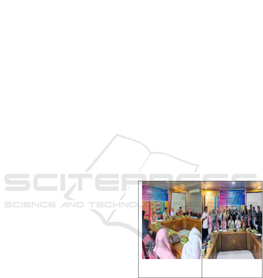
3.3 Socialization and FGD (Focus Group
Discussion) Regarding Drought
Resilient Disaster
Drought is a type of complex natural disaster
characterized by a long-term water shortage. Drought
occurs slowly (slow on-set) with a duration until the
rainy season arrives, and has a very broad impact and
is cross-sectoral (economic, social, health, and
education) (IRBI, 2015). Drought can be caused
because an area does not experience a rainy season or
dry season for a long period of time or rainfall is
below normal, so that the water content in the soil
decreases or even disappears. According to Indarto et
al., (2014) in general, the beginning of a drought
disaster cannot be known, but it can be said that
drought occurs when the available water is no longer
sufficient for daily needs. Land damage and the
impact of losses caused by drought are very extensive
and the economic value of the losses is quite large.
Drought can be classified based on the characteristics
and impacts caused. The FGD related to drought was
held on Wednesday, September 19, 2024 at the office
of the Head of Limo Kaum Village, which was
attended by representatives of farmer groups, village
heads and village officials. The resource person other
than the UNP team led by Mrs. Dr. Ratna Wils, S.Pd,
MP was also present, the Head of BMKG Bukit Koto
Tabang, namely GAW Station, Mr. Dr. Sugeng
Nugroho, S.Si, M.Si. He provided material related to
drought and disasters that often hit the Limo Kaum
village area, especially the galodo disaster.
Community resilience strategies for drought
can be done by: 1) Saving water during the dry
season, accompanied by making water storage
containers when it rains and very useful for
farmers during the dry season later, 2) Farmers are
disciplined in following the planting patterns
prepared by the agricultural service and are on the
website siaptanam.bsipkementan.id, 3)
Utilization of agricultural waste to make compost,
4) utilization of fruit and vegetable waste to make
eco-enzymes.
The FGD event was
opened by the Mayor of
Limo Kaum Village
Group Photo of FGD
Participants
Figure 3: Socialization and FGD on drought management
with the community and farmer group members.
The long-term strategy that must be done is to
prepare activities for the coming year, coincidentally
this will continue for the next 2 years with continued
activities to increase farmers' knowledge in
overcoming drought.
Specifically, there are four types of drought
(Wilhite, 2010), namely:
a. Meteorological Drought This type of drought
refers to a lack of rainfall compared to average
Becoming a Resilient Community Fighting the Drought Disaster
47

conditions, over a long period of time. The
intensity of the drought is determined by
meteorology.
b. Agricultural Drought Agricultural drought is
defined as a decrease in the availability of
groundwater below the optimum level required by
rice plants at any stage of their growth and reduces
crop yields. The intensity of drought according to
the agricultural definition is assessed by the
percentage of dry leaves. area for rice plants.
c. Hydrological Drought Drought occurs when there
is a decrease in the availability of water on the
surface and underground due to reduced rainfall,
which is characterized by a significant reduction
in surface water flow to below normal conditions
or the cessation of groundwater recharge.
d. Socio-economic drought This type of drought
occurs when there is a disruption in human
activities due to reduced rainfall and water
availability. This form of socio-economic drought
links human activities with meteorological,
agricultural, and hydrological drought elements.
Our planting pattern provides solutions to
farmers by guiding them to the planting pattern that
has been prepared by the government. We provide
socialization based on the computer-based ready-
to-plant web on the siaptanam.bsipkementan.id web.
From the web results for the Lima Kaum Regency
area, the planting pattern for October-March 2025 is
Paddy-Paddy-Paddy, since it is still in the rainy
season. The farming community was very
enthusiastic in following the training provided, in
the socialization session, 25 farmers who were
invited were all present. During the training on
making eco-zymes and arranging planting patterns,
all the invited farmers also came, coincidentally
representatives from the invited group members.
The village head was always present and gave full
support to this activity.
3.4 Making Eco-Enzymes to Increase
the Utilization of Vegetable and
Fruit Waste
Ecoenzyme is a dark brown complex organic
substance solution with a strong fresh sour aroma,
produced from the fermentation of vegetable and fruit
waste with the addition of sugar and water. In general,
ecoenzyme can be used as a multipurpose cleaning
fluid for household purposes such as washing dishes,
mopping, cleaning bathrooms, and so on. Ecoenzyme
Enzyme is fluid dark chocolate fermented from water,
fruit and vegetable skins, and brown sugar in a ratio
of 10 : 3 : 1. Eco Enzyme i s very easy to make,
especially for mothers who have a lot of fruit and
vegetable waste. This liquid can be used as a
household cleaner and as fertilizer and also pesticide
experience which is effective. Eco Enzyme can also
reduce the greenhouse effect and global warming,
provide benefits to marine plants and marine biota,
and reduce pollution. Eco Enzyme is solution
substance organic complex made from the
fermentation process of organic residue, sugar, and
water. (Nisawati and Yahya, 2020).
One of the efforts to boost agricultural
productivity is by applying Eco enzyme to plants
that can be used as natural pesticides and also as
organic fertilizers and bio fertilizers, by using eco
enzymes will also reduce the use of chemical
fertilizers sustainably. The benefits of eco enzymes
for agriculture are as air filters, natural herbicides
and pesticides, reducing indoor smoke, water
filters, natural fertilizers for plants and reducing the
greenhouse effect. How to apply eco enzymes to
rice fields as fertilizer is by spilling eco enzymes
into rice field irrigation. Eco enzymes can also be
used as compost by mixing other ingredients and
adding eco-enzyme liquid. Hopefully eco-enzymes
can be useful for overcoming drought in
agricultural land because the soil will be more
fertile and the organic matter of the soil will
increase.
Types of Waste can be grouped into several
categories, namely: 1) based on origin suggestion, 2)
characteristics, And 3) Form. Types of waste are
divided into 2 (two) types. as follow: 1) rubbish
organic and 2) rubbish inorganic. Rubbish organic is a
type of waste that can be broken down into other
items compost, like remainder food, dry leaves,
vegetables. (Prasetio et al ., 2021). Inorganic waste is
waste that cannot be regenerated and takes a long time
to decompose. However, inorganic waste inorganic
Can recycled repeat into something useful. For
example, plastic bottles, used paper, boxes, and used
cans. Inorganic waste difficult to process into
environmentally friendly materials so that it becomes
an environmental problem. (Muarief et al ., 2023).
Processing of vegetable and fruit waste includes
activities that apply a technoecological agricultural
model, namely utilizing waste from the surrounding
environment and including efforts to increase farmer
productivity in cultivating their land (Wilis, 2017).
This research can increase farmers' knowledge in
overcoming drought by regulating planting patterns,
as well as knowledge in overcoming galodo disasters,
namely by increasing land fertility and making eco-
enzymes, namely multi-purpose solutions. As many
as 80% of the farming community can already do this.
ICHELS 2024 - The International Conference on Humanities Education, Law, and Social Science
48

In the future, in addition to several stages to deal
with the drought above, we also need to do several
things to prepare for drought with broader disaster
management in order to overcome the various risks
faced by farming communities, namely 1) Complying
with and being alert to weather information from
BMKG, 2) Making water containers, especially used
during the rainy season and sangar means used in the
dry season, 3) Complying with the planting patterns
that have been prepared by the relevant agencies and
trying to plant simultaneously, 4) Increasing land
productivity after the galodo disaster by utilizing
agricultural waste such as making compost, eco-
enzymes, botanical pesticides, processing agricultural
products and others, 5) Land management based on
conservation because nature in this location tends to
be rough.
4 CONCLUSION
Drought can have very broad, complex and long-term
impacts after the drought ends. This broad and long-
term impact is because air is a basic and vital need for
all living things that cannot be replaced by other
resources. The impact on the agricultural sector is
limited irrigation water, reduced planting area,
decreased land productivity, decreased food crop
production, and decreased farmer income.
Meanwhile, from the social sector, drought disasters
can cause widespread division and conflict, including
conflicts between water users and between
governments. The results of this study are: 1)
increased community knowledge and skills in dealing
with drought disasters, 2) increased community
knowledge and skills in maintaining and restoring the
fertility of their rice fields, especially after the Galodo
disaster, 3) increased knowledge and skills in dealing
with drought disasters, regulating planting patterns
especially in adapting to unbalanced dry and rainy
season conditions, 4) increased farmer knowledge in
making Eco Enzyme.
THANK-YOU NOTE
We would like to thank Padang State University and
all parties involved.
REFERENCES
City Regional Regulation Number 6 of 2019 Concerning
the Medium-Term Regional Long-Term Development
Plan (Rpjmd) for the City Sector in 2019-2024. 2019.
Faiza, Elijah Noor. 2023. Analysis of Drought-Prone Area
of Rice Fields in Purworejo Regency Using Geographic
Information Systems. Journal of Geodesy and
Geomatics. Volume 6 Number 1 2023.
Ministry of Environment and Forestry, NTT Regional
Government. 2015. Vulnerability and Climate Risk
Management in the Agriculture, Water Resources, and
Community Life Sources Sectors in the Southeast East
Region. ITB. Bogor.
Muarief, R., Aziz, M, Priyanto, Thousani, HF, Juliana, I,
Syarifah, I., Setiawan, AD, Amir, V. (2023). Household
Waste Processing into Eco Enzyme in Ujung Residence
Housing Environment. ABDIMAS Journal
(Community Service) UBJ, 6 (1), 73-80
Nisawati, I and Yahya, A. (2020). Utilization of Eco-
Enzyme in Optimizing the Role of Housewives in
Jatibaru Village, Cikarang, Bekasi Regency. Sriwijaya
Community Service Journal, 8 (4), 1294-1302.
Padang City Government 2019
Permadi, M Galih. 2019. Study of Drought Disaster Risk in
Cianjur Regency. Journal of Geography, Education and
Environment (JGEL) Volume 3 Number 1, January
2019.
Prasetyo, VM, Ristiawati, T., Frida Philiyanti. (2021).
Benefits of Eco Enzymes for the Environment and Eco
Enzyme Production Workshop. Darmacitya, 1 (1), 21-
29
Pratiwi, EPA, Ramadhani, EL, Nurrochmad, F. and
Legono, D. (2020), "The Impact of Floods and Drought
on Food Security in Central Java", Journal of Civil
Engineering Forum, Vol.6, No.1, pp. 69–78.
http://doi.org/10.22146/jcef.51872.
Rahman, Fadli. 2012. Analysis of Drought on Agricultural
Land Using NDDI Method and Per KABNPB No. 02
2012. Geodesy Journal. UNDIP.
Research and Development Agency. 2021. RPJMD of Land
District Government 2021-2026.
Surmaini, Elza. 2016. Monitoring and Early Warning of
Agricultural Drought in Indonesia. Journal of Resource
Land Volume 10 Number 1. July 2016.
Syamsyuri, Ulfa Aulia. 2021. GIS-Based Mapping of Rice
Field Drought Levels in Takalar Regency. Journal of
Environmental Science Volume 3, Number 2 April
2021.
Veni, Ni Kentut. 2021. Impact of Drought on Toadi Crop
Production in The Great Plains District using Far NDVI
Sensing Method. Journal of Geoscience Volume 7
Number 1 Year 2021.
Widyastuti, R. (2020), “Drought Distribution Pattern in
Simpenan District Using the “SPI (Standardized
Precipitation Index)” Method, Jurnal Geosaintek,
Vol.6, No.1, pp. 19– 24.
http://doi.org/10.12962/j25023659.v6i1.6272 .
Wilis, Ratna, Eri, B, Nurhasan, S, Aldri, F, Deded, C,
Linda, H. 2024. Development of the basic land capacity
Becoming a Resilient Community Fighting the Drought Disaster
49

of food agriculture areas in Dharmasraya Regency,
West Sumatra Province. International Conference on
Environment, Mining and Sustainable Development
2022. AIP Conference Proceedings. Volume 3001,
Issue 1
Wilis, R. 2017. Agricultural Geography. Sukabina Press.
ISBN: 978-602-6277-62-6 Padang.
Wilis, R., E. Barlian, D. Hermon, I. Dewata, and I. Umar.
2020. Evaluation of Land Carrying Capacity for Food
Agriculture Based on Land Degradation in Pagar Alam
City, Indonesia. International Journal of Management
and Humanities (IJMH). Vol. 4. Issue 9. pp. 15-19.
ICHELS 2024 - The International Conference on Humanities Education, Law, and Social Science
50
