
The Optimization of Flood Control Man-Made Channel Systems in
Northwest Beijing: Responding to the Challenges of Climate Change
and Extreme Weather
Yanzhi Wen
a
Department of Earth Science & Environmental Change, University of Illinois at Urbana-Champaign, Illinois, U.S.A.
Keywords: Man-Made Channel Systems, Extreme Weather, Beijing.
Abstract: Northwest Beijing has frequently suffered from flooding in recent years, and the existing artificial aqueduct
system has certain limitations in flood prevention effect. Especially when heavy rainfall comes, the
precipitation often exceeds the carrying capacity of the existing drainage system, leading to serious
waterlogging and flooding disasters. Therefore, it is of great significance to explore the optimization measures
of aqueduct design and management. Based on the field study, this paper analyzes the deficiencies of the
aqueduct system in the region in response to extreme weather events and proposes a plan to improve the
system's diversion and flood control capacity through design optimization, intelligent monitoring and early
warning, and natural ecological management from multiple perspectives. This paper shows that insufficient
redundancy in aqueduct design and poor maintenance are the main challenges, while intelligent management
and public participation mechanisms can help improve the system's responsiveness and adaptability. This
study provides new ideas for the design of urban hydraulic projects, especially to cope with floods, mudslides
and other disasters caused by climate change.
1 INTRODUCTION
Climate change has led to a high incidence of extreme
weather events, especially the increase in the
frequency and intensity of extreme precipitation
events, which has put tremendous pressure on the
infrastructure of major cities around the world.
Flooding has become one of the major challenges for
many cities, not only endangering the safety of
residents' lives and property, but also having a serious
impact on key urban functions such as transportation,
water supply, and electricity. According to the United
Nations, a large proportion of global flooding occurs
in urban areas, a risk that is further exacerbated by
climate change (Xuehai, 2024). Urbanization has
accelerated surface hardening and reduced the water
storage capacity of natural water systems, making
cities more vulnerable to flooding when faced with
extreme precipitation (Zhou, 2023). Therefore, how
to mitigate the impacts of flooding through effective
water resource management has become a key topic
of research.
a
https://orcid.org/0009-0001-6723-9708
Currently, there are various research methods for
coping with urban flooding, including Low Impact
Development (LID) techniques (UN-Habitat, 2022).
Monitoring and management of urban drainage
networks using remote sensing and Geographic
Information Systems (GIS) (Ding, 2014). Among
them, artificial aqueducts, as an important
infrastructure, have attracted much attention due to
their significant role in guiding urban runoff, rapid
drainage, and water storage and flood control.
This paper argues that aqueduct design
optimization and systematic management can
significantly improve the ability of cities to withstand
flooding, especially when dealing with extreme
precipitation events (Li, 2023).
This paper takes Northwest Beijing as the research
object, discusses the current situation and problems of
its existing artificial aqueduct system in flood
prevention and flood control, analyzes the optimized
design scheme, and provides effective solution ideas
for urban flood control management.
Wen, Y.
The Optimization of Flood Control Man-Made Channel Systems in Northwest Beijing: Responding to the Challenges of Climate Change and Extreme Weather.
DOI: 10.5220/0013337400004558
Paper published under CC license (CC BY-NC-ND 4.0)
In Proceedings of the 1st International Conference on Modern Logistics and Supply Chain Management (MLSCM 2024), pages 429-432
ISBN: 978-989-758-738-2
Proceedings Copyright © 2025 by SCITEPRESS – Science and Technology Publications, Lda.
429
2 OVERVIEW ANALYSIS OF THE
STUDY AREA
2.1 Overview of Beijing's Geographic
Location and Flood Risk
Beijing is located in the north of the North China Plain
in northern China, at the junction of the eastern
Taihang Mountains and the southern Yanshan
Mountains. The overall topography of the city
gradually decreases from northwest to southeast, with
mostly mountains in the northwest and plains in the
southeast. Due to this geographic location, the
northwestern area of Beijing becomes a key area for
precipitation and flash flood convergence, while the
plains in the southeast are prone to waterlogging and
the formation of inland floods (Liu, 2015).
Northwestern Beijing, including Changping,
Yanqing, and Mentougou, has a complex topography
dominated by mountains and hills. The region is rich
in rivers and valleys and is prone to heavy
precipitation and flash floods during heavy rainfall.
Due to the steep terrain, heavy rainfall in the
northwestern mountainous areas is very likely to
converge into rapid flows and quickly pool into flash
floods, posing a greater threat of flooding to
downstream areas (Meteorological Bureau, 1990).
Beijing has a typical monsoon climate, with
precipitation mainly concentrated in the summer
months of July and August, accounting for about 70%
or more of the annual precipitation. In the
northwestern part of the country, precipitation is
relatively large due to the uplift effect of the terrain,
but it is unevenly distributed, and heavy rainfall
events are frequent, especially during heavy rainfall,
which can easily lead to flash floods and mudslides.
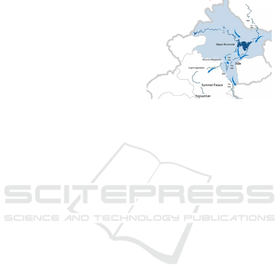
2.2 Distribution of Water Systems
Beijing's water system mainly includes the Yongding
River, Chaobai River and Wenyu River. The
Yongding River basin in the northwestern part of the
city is one of the most important water systems in
Beijing, but it is also susceptible to flash floods and
mudslides due to the fact that it flows through
mountainous and hilly areas. In addition, the
numerous small streams and valleys in the
northwestern region rapidly accumulate water during
rainfall, resulting in rapid flood confluence and high
flow rates, exacerbating the risk of flooding (Figure
1).
Figure 1: Map of water systems in northwestern
Beijing (Li, 2023).
This article will focus on why the existing man-
made aqueduct system in the Northwest Fifth Ring
Road of Beijing is not able to fully withstand flooding.
What are the main challenges in gutter design and
flood management?
3 DESIGN
From the design point of view of water conservancy
engineering, the main task of the artificial canal and
river system is to guide and control the stormwater
runoff in order to reduce the impact of flooding on the
city. In this paper, a field study was conducted to
observe the situation of rivers in northwest Beijing
(Qing River, Beisha River, Yongding River,
Yuanmingyuan River, Xijiao Line Drainage Canal,
and Zizhuyuan River). Artificial canals and river
systems fulfil their roles of diversion, diversion, flood
control, and water storage mainly through their
dimensions, layout structures, and drainage network
structures (Wang, 2011).
Traditional canal systems are often designed
based on historical rainfall data and lack
consideration for extreme weather events. The warm
semi-arid and semi-humid monsoon climate of
Beijing (with distinct dry and rainy seasons, long
duration of the rainy season, high cumulative rainfall,
strong winds, and obvious convective characteristics
with some extremes) requires a higher degree of
adaptability and flexibility in the design of the
aqueduct. For example, the cross-section of the drains
should be designed to accommodate stormwater
runoff of varying intensities with some redundancy
(adding additional drainage channels or structures) to
cope with extreme weather events (Ma, 2018).
MLSCM 2024 - International Conference on Modern Logistics and Supply Chain Management
430

With the complex topography of northwestern
Beijing, man-made drains need to be closely
connected to natural water systems and drainage pipes
to ensure that stormwater is quickly discharged to a
safe place. This requires full consideration of
geographical factors such as terrain elevation and
catchment paths in the layout of the drains.
4 SOLUTION ANALYSIS
Design and optimization: Dynamic simulation of the
aqueduct system is carried out using the SWMM
modelling tool, which can simulate the water storage
system or the aqueduct system under any scenario.
For example, if the average rainfall over a period of
time is set for an area of apartments, and the roof of
each apartment is covered with greenery, the
rainwater is stored for a certain period of time on the
roofs of the apartments in the greenery-covered areas,
and then flows into the apartment's aqueducts, then
into the city's aqueducts, and ultimately into the man-
made canals or rivers. This makes it easier to ensure
that the design of the distribution system is adaptable
to different rainfall scenarios.
In terms of natural ecological management, this
paper suggests the construction of small natural parks
next to man-made aqueducts and rivers to enhance the
filtering and storage of rainwater in aqueducts by
incorporating natural landscapes, such as wetlands
and vegetated buffer zones, which can improve flood
control and the urban environment. The
Yuanmingyuan and the Summer Palace are the most
successful cases in northwest Beijing, but their
specifications and costs are also huge. But if you just
build linear parks along the banks of rivers, they can
also serve the same purpose of water storage and
flood control.
From the point of view of management and
maintenance, man-made aqueducts and rivers require
not only rational design but also proper management
and maintenance. Many aqueducts were designed
with adequate drainage and water conveyance
capacity, but due to a lack of maintenance over a long
period of time, problems such as silt and garbage
accumulation have occurred, resulting in poor
drainage. As in the case of the river park proposed
above, the trees and vegetation inside the park will
drop a large number of leaves, twigs flowers, etc.
every year and these will seriously affect the proper
functioning of the drainage system. Therefore, it is
very important and meaningful to maintain the drains
and rivers regularly.
If not cleaned in time, the drains will fail at critical
moments and cause serious flooding. Also, smarter
management and maintenance models are essential.
Traditional management of drains relies on manual
inspections and regular maintenance, but with the
development of technology, IoT devices and sensor
networks can help to monitor the operation of drains
in real time, and identify blockages or points of failure
more quickly and with less effort.
4.1 Smart Monitoring and Early
Warning System
By installing smart sensors such as rotary slurry flow
meters and multi-parameter water quality analyzers to
monitor changes in water levels, flow rates and water
quality in drains, real-time flood risk warnings are
provided and automatic reminders are given to
maintain or activate drainage equipment. Such
systems can be integrated with meteorological
forecast data for advanced flood risk assessment.
Drawing on the public reporting system used by
Goldmind, mobile applications are used to engage
citizens in the management of drains, where citizens
can report blockages or breakages they find, which in
turn allows professionals to carry out maintenance
and repairs, improving the responsiveness of drains.
From a sustainability perspective, while
addressing flooding, the aqueduct system also needs
to consider sustainable development, especially the
long-term health of the urban environment and
ecosystems. Runoff during the rainy season in Beijing
is a potential water resource if it can be properly
collected and treated, the management and reuse of
precipitation resources, such as for urban power
generation, greening, landscape water and other areas.
This will not only alleviate the problem of urban
flooding but also improve the efficiency of water
resource utilization. Moreover, flood water often
carries a large number of pollutants (organic
pollutants, metals, chemical pollutants, and microbial
pathogens), which may affect the water quality of the
downstream water bodies after entering the aqueduct.
Therefore, the design of aqueduct systems should not
only consider drainage but also incorporate water
quality purification features (Bach, 2017).
4.2 Harvesting Rainwater for Reuse
By setting up rainwater collection ponds at suitable
locations in urban or suburban areas, the precipitation
from nearby areas (residential areas, roads and other
hardened areas) can be collected to the maximum
extent, and through filtration and sedimentation,
floating particles and larger pollutants can be
The Optimization of Flood Control Man-Made Channel Systems in Northwest Beijing: Responding to the Challenges of Climate Change
and Extreme Weather
431

removed, and then through sand filtration and
secondary sedimentation, the vast majority of
particles obtained can be removed, and then after that
chlorine disinfection or ultraviolet ray disinfection
can be used to kill the microorganisms and pathogens
in the water, and finally, the ph value is adjusted to a
usable range. The water can then be used for non-
potable water supplies such as irrigation, cleaning,
cooling water and toilet flushing.
Incorporating filtration layers and settling basins
directly into the man-made aqueduct system reduces
the chance of pollutants entering the natural water
body. This can be at the intersection of each aqueduct,
which is usually equipped with a sluice gate. A filter
layer that can be raised and lowered at the inlet can be
installed, consisting of a large barrage and gravel. It
can be ensured that the drains do not become clogged
with clumps or larger pollutants during any time,
resulting in the loss of unclogging. Natural biological
filtration can also be done using the river parks
mentioned above, where wetland plants, aquatic
organisms and other natural elements purify the water.
They absorb some of the nutrients in the runoff, such
as nitrogen and phosphorus, and convert these
potential pollutants into harmless biomass through
plant growth, thus reducing the risk of eutrophication
of the water body. It also stops the soil on both sides
of the aqueduct from being excessively washed into
the aqueduct by the water flow.
5 CONCLUSION
This paper discusses the limitations and challenges of
the existing artificial aqueduct system in flood
prevention and control by analyzing the geographic
characteristics, precipitation distribution, and water
system in northwest Beijing. By combining multiple
perspectives of hydraulic engineering design, system
maintenance and intelligent management, and natural
ecological management, it is found that although the
existing aqueduct system can prevent and control
flooding to a certain extent, it still suffers from
insufficient design redundancy and poor maintenance
in coping with extreme weather events.
In addition, the study points out that the flood
prevention and control capacity of the aqueduct
system can be effectively improved by using
modelling tools such as SWMM for dynamic
simulation, enhancing the flexibility of aqueduct
design, introducing intelligent monitoring systems
and public participation mechanisms, and natural
ecological management tools.
With the frequent occurrence of extreme climate
events, the design and management of man-made
aqueduct systems need to be further optimized to
better adapt to the flooding risks associated with
climate change. Meanwhile, this study not only
provides practical guidance for urban flood control in
Beijing but also provides a reference for the
construction of water conservancy projects and urban
management in other similar areas. The efficiency and
sustainability of urban water management systems
can be further enhanced in the future through more
interdisciplinary studies and field tests, leading to
higher ecological and social stability.
REFERENCES
Bach, P. M., McCarthy, D. T., & Deletic, A. 2017. GIS-
based SWMM model for simulating the catchment
response to stormwater harvesting. Hydrology
Research, 48(2), 384-396. SCITEPRESS.
Ding, H., Kang, J., Song, X., & Li, C. 2014. SWMM
application in designing and planning LID systems.
Urban Water Journal, 12(6), 1-8. SCITEPRESS.
Li, Z., & Wang, S. 2023. Remote sensing and GIS-based
water management systems in China. In Water and
Environmental Management: Advances and
Challenges. SCITEPRESS.
Liu, J., Chen, G., Wang, H., Chen, X., Lu, L. 2015. Storm
Water Management Model Theory and Application—
Take SWMM as an Example. Science Press, Beijing.
Ma, X., Chen, C., & Wang, C. 2018. Application research
of SWMM in the simulation of large-scale urban rain
flood process: A case study of Yizhuang District, China.
In W. G. Al-Soufi.
Meteorological Bureau. 1990. Precipitation in China.
Retrieved on 2024 from https://www.ceicdata.com/zh-
hans/china/precipitation
UN-Habitat. 2022. World Cities Report 2022: Chapter 5.
Retrieved from https://unhabitat.org/sites/default/
files/2022/07/chapter_5_wcr_2022.pdf
Wang, H., Chen, J., Zhang, S., et al. 2011. Application
status and comparative analysis of urban storm flood.
Water Resour. Hydropower Eng. 42, 10–13.
Xuehai Document. 2024. Beijing Water System Map.
Retrieved from https://doc.xuehai.net/b7bbd6a44aee
cbb1161a2b136.html
Zhou, Q., Li, X., & Zheng, F. 2023. GIS-based SWMM
model for urban flood simulation in China. Water,
16(11), 1464. SCITEPRESS.
MLSCM 2024 - International Conference on Modern Logistics and Supply Chain Management
432
