
Research on the Development of Urban Mixed-Use Neighborhoods
Under the TOD Model: The Case of Shanghai Chuangzhitiandi
Neighborhood
Jiaxing Huang
a
College of Architecture And Urban Planning, Tongji University, Shanghai, China
Keywords: TOD, Urban Design, Mixed-use Neighborhood, Chuangzhitiandi.
Abstract: As China's industrialization and urbanization levels increase, cities will accommodate more and more people.
To avoid the disordered expansion caused by the rapid development of cities, future urban construction needs
reasonable theoretical guidance, and the transit-oriented development (TOD) development model has become
an important reference for China's urban construction at this stage. This paper analyzes the advantages and
shortcomings of the case study of Shanghai's Genesis World Neighborhood through the lens of urban design
and puts forward suggestions for improvement. The Chuangzhitiandi Neighborhood attracts a large number
of people through the public transportation hub, creating a vibrant business district. A convenient underground
pedestrian system connects each building and directs the pedestrian flow brought by public transportation to
the interior of the community. The reasonable pedestrian scale of the internal streets and the verticalization
of building functions on both sides of the streets make the neighbourhood more dynamic. However, the single
business format and lack of vitality of the sunken plaza are the shortcomings of the case. It is necessary to
increase the number of restaurants and entertainment functions, as well as to add a more recognizable visual
guide design for the underground pedestrian system. The urban design analysis of the Chuangzhitiandi
neighbourhood can provide a reference for similar projects in the future.
1 INTRODUCTION
As China's level of industrialization and urbanization
continues to rise, mega-cities are gradually becoming
centers of population and economic concentration. It
is expected that in the future, 70% of China's
population will live in cities, many of whom will be
concentrated in these mega-cities. With the massive
influx of population, urban development is facing
many challenges, such as over-sized cities, disorderly
expansion of built-up areas, traffic congestion, and
underutilization of urban space, etc. At this stage, new
city construction and urban renewal need to be guided
by a unified concept to avoid chaotic and unorganized
urban construction. In this context, the transit-
oriented development (TOD) model can guide new
town construction and urban renewal (Shuai, 2024).
The TOD development model can impro ve the
efficiency of transportation travel and enhance the
connection of urban areas. Comprehensive nodes
a
https://orcid.org/0009-0007-5011-6182
formed around transportation hubs contribute to the
construction of urban living circles, which is in line
with the development needs of Chinese cities
nowadays.
Most of the TOD development mode takes high-
speed rail stations, bus stations, subway stations and
other public transportation nodes as the center of the
area, and builds relevant facility clusters within 10-15
minutes of walking distance (Perry, 2015). The
internal functions of the clusters can satisfy the needs
of the urban residents in terms of work, business,
culture, education and residence, thus reducing the
use of private cars and building a green city where
public transportation is the main mode of travel.
According to the study by Anna Ibraeva et al,
According to Anna Ibraeva et al, although most of the
research on the topic of TOD comes from the United
States, there is also a growing interest in TOD in the
Asia-Pacific region, and TOD-related research is
spreading widely internationally (Ibraeva, 2020).
Huang, J.
Research on the Development of Urban Mixed-Use Neighborhoods Under the TOD Model: The Case of Shanghai Chuangzhitiandi Neighborhood.
DOI: 10.5220/0013329400004558
In Proceedings of the 1st International Conference on Modern Logistics and Supply Chain Management (MLSCM 2024), pages 289-293
ISBN: 978-989-758-738-2
Copyright © 2025 by Paper published under CC license (CC BY-NC-ND 4.0)
289

So far, Chinese scholars' research in the field of
TOD mainly focuses on the integration of station
cities and the perspective of land space policy. Yang
Jiawen, Duan Yang et al. studied the land preparation
mode in the process of TOD development in
Shanghai, Dongguan and Shenzhen (Yu, 2020). Li Xi
analyzed the architectural and traffic flow design of
the station-city integration of Guangzhou Baiyun
Station from the perspectives of traffic connection,
functional layout and cultural design (Xi, 2024). Dai
Peng et al. evaluated the renewal potential of rail
transit stations from the perspective of TOD by
establishing an index system (Peng, 2024). Liao
Yuqing analyzed the practical process of promoting
TOD station-city integration in Nanning City and
made an outlook on the development prospect of TOD
station-city integration in Chinese cities (Lu, 2023).
These studies not only provide a theoretical basis for
the development of the TOD model in China but also
lay the foundation for its practical application in
different cities. However, the existing studies focus
more on analyzing and interpreting policy theories,
development models and other macro perspectives,
and less on the urban design perspectives of specific
projects.
This paper aims to analyze the realization of
station-city integration under the TOD mode from the
perspective of urban design in terms of traffic flow
organization and functional zoning layout by taking
Shanghai Chuangzhidiandi Neighborhood as an
example. By analyzing the overall planning and
specific design techniques of the project, this paper
can provide a reference for the future design of TOD
urban integrated neighborhoods and the construction
of urban living areas.
2 DEVELOPMENT AND
ADVANTAGES OF THE TOD
CONCEPT
2.1 Development of the TOD Concept
In the early 20th century, the Englishman Ebenezer
Howard put forward the concept of garden cities, he
pointed out that several garden cities should be built
around a central city to form urban clusters. Each
garden city covers an area of about 6,000 acres and
contains industrial land, agricultural land, stores,
schools and other services. The cities are linked to
each other by railroads (Howard, 2013). The idea of
clustering garden cities and linking them with
railroads is already a prototype of the TOD model. In
the 1920s, Clarence Perry, an American planner,
comprehensively described the planning concept of
Neighborhood Unit. He believed that the
Neighborhood Unit is a “plan for a community that
organizes family life” (Sharifi, 2016), and that in each
unit there is not only housing, but also retail stores,
schools, recreational facilities, and other public
services, as well as requirements for specific planning
details for each unit.
Since the 1980s, the concept of TOD has been
gradually developed. Calthorpe, an American
architect and urban planner, specifically defined TOD
as “mixed-use neighborhoods within an average
walking distance of 2,000 feet from transit stations
and core business districts (Calthorpe, 1993). These
neighborhoods include residential, retail, office,
public service and open space components. Since
then, the TOD concept has gained popularity and
research has been abundant in this area.
2.2 Advantages of the TOD Development
Model
The TOD model provides a fast and efficient green
travel mode. Residents living in mixed-function urban
areas within a certain range of public transportation
nodes can enjoy a wide range of urban functions and
public services within a 10-15 minute walk, which
meets their daily needs. For long-distance travel
needs, public transportation stations in the centre of
urban clusters can be used to take public
transportation, which enhances the use of public
transportation, reduces the use of private cars, and is
conducive to green and sustainable urban
development. At the same time, public transportation
stations in the TOD model can attract a large number
of people. And because of its superior transportation
and logistics conditions, it can form a business district
with a strong consumer atmosphere, bringing
economic vitality to the surrounding urban areas. In
addition, the TOD model helps to change the
development structure of the original urban sprawl
and form new transportation hubs. It also relieves the
pressure of traffic and pedestrian flow brought by a
single city center, forming a multi-center urban
development pattern.
3 THE CASE OF SHANGHAI
CHUANGZHITIANDI
NEIGHBORHOOD
With the gradual improvement of the TOD theory,
MLSCM 2024 - International Conference on Modern Logistics and Supply Chain Management
290
there is a growing interest in the construction of TOD
projects worldwide. As a completed TOD urban
mixed-use neighborhood project in China,
Chuangzhitiandi Neighborhood has maintained
sufficient vitality since its completion. Analyzing the
urban design of the Chuangzhitiandi Neighborhood,
can provide a reference for the construction of other
TOD projects.
3.1 Overview of the Chuangzhitiandi
Neighborhood
Located in the Wujiaochang sub-center area of
Yangpu District, Shanghai, China, approximately
9km from the city center, the Chuangzhitiandi
Neighborhood was developed by Shui On Land and
master planned and designed by SOM Associates.
Fudan University, Shanghai University of Finance
and Economics, Tongji University and other
institutions of higher learning are concentrated in the
surrounding area. A large young population provides
the area with plenty of vitality, and the resources of
the universities have attracted many technology-
based companies and entrepreneurs to move in.
Therefore, the Chuangzhitiandi Neighborhood needs
to be planned to meet the consumption needs of the
relevant population. At the same time, the project
should provide a suitable environment for business
members and innovative entrepreneurs in the
knowledge-based community, such as a collection of
office spaces for R&D, education, training,
investment and incubation organizations, and a
vibrant public sports space and living community
within the site.
3.2 Traffic Organization
The case block is located in the Wujiaochang urban
sub-center of Shanghai, with Songhu Road, the city's
main artery, running through the site. Wujiaochang is
named after the intersection of Handan Road, Siping
Road, Huangxing Road, Xiangyin Road and Songhu
Road in the northeastern corner of Shanghai, and is an
important transportation hub in the northeast of the
city. The transportation network in the area is
complete, with Metro Line 10 passing through and
including Wujiaochang Station and Jiangwan
Stadium Station. More than 10 bus routes run through
the area.
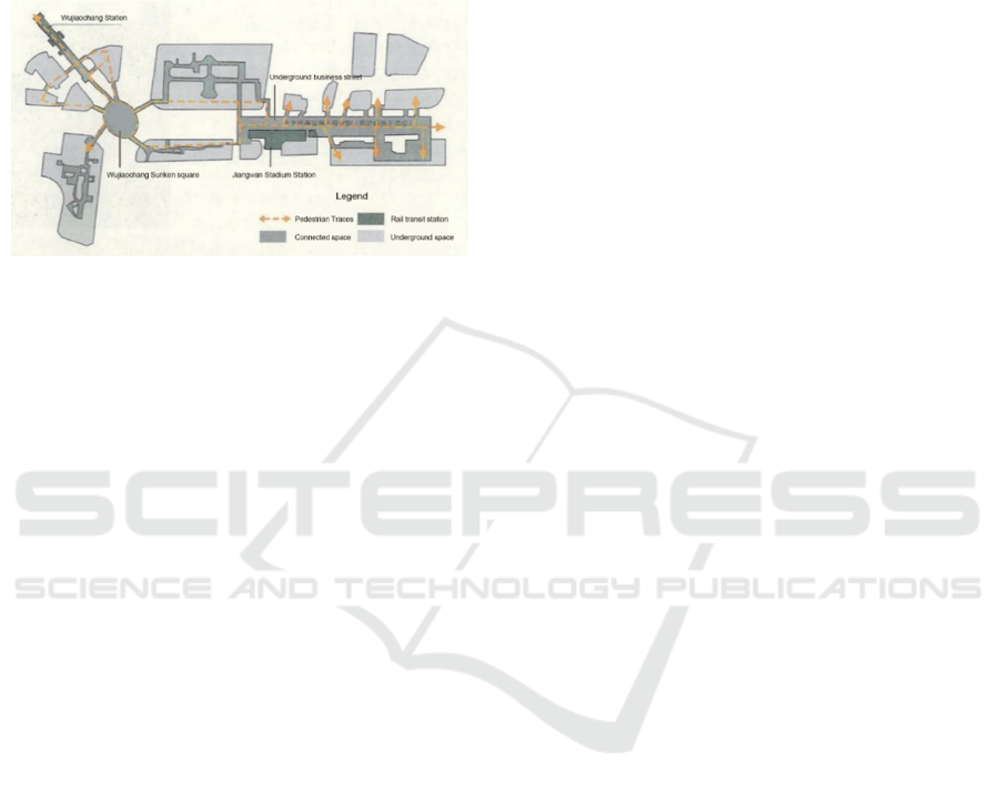
In addition, the Middle Ring Road and Railway
Line 10 build a three-dimensional transportation
network through elevated roads, vehicular tunnels and
underground pedestrian systems. The sunken plaza at
the center intersection is directly connected to the
basement level of the Pentagon Center subway station
and surrounding buildings. When passengers exit
from the Wujiaochang subway station, they can pass
through the sunken plaza and directly enter the
interior of the surrounding buildings. The commercial
street constructed underneath Songhu Road becomes
a corridor linking the Wujiaochang Metro Station and
the Jiangwan Stadium Metro Station. Through the
commercial street, the pedestrian flow will be
directed to the Metro Station, Daxue Road, Zhengmin
Road, Zhengtong Road, Jiangwan Stadium,
Chuangzhitiandi Plaza and other places along the
route. Pedestrians no longer have to cross the street
from the ground level and jostle with the traffic. The
overall business atmosphere is perpetuated, while the
pedestrian flow from the two metro stations ensures
the commercial vitality of the neighborhood. The use
of convenient public transportation to drive
development is in line with the development ideas of
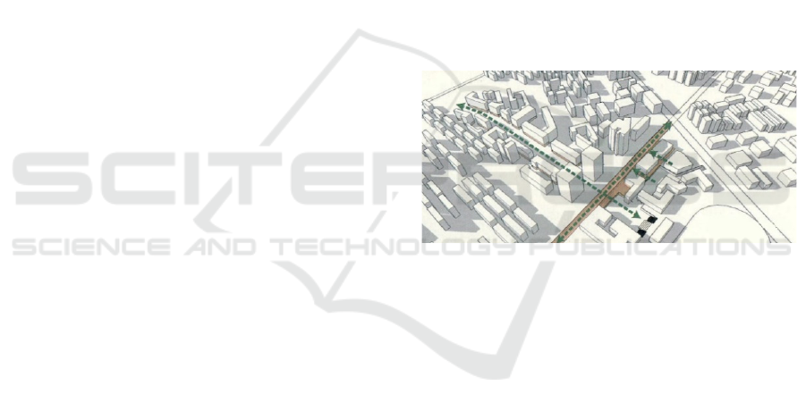
the TOD model. Figure 1 shows the underground
pedestrian system in the area.
Figure 1: Underground pedestrian system(Huang,
2021).
The public space on the ground level is organized
on the axis of Songhu Road and Daxue Road (Figure
2). The sunken public square along Songhu Road has
a total area of about 13,000 square meters. It can be
divided into two sunken plazas in the north and south,
with a sinking depth of about 5 meters. The north
sunken plaza consists of 7 modern-style intelligent
office buildings and is connected to the south sunken
space, with an area of more than 5,100 square meters;
the south sunken space is directly opposite the
Jiangwan Stadium and is also the main entrance to the
entire sunken space, which is roughly a rectangular
space with a width of 6 meters and a length of 120
meters. The area is about 7,800 square meters. On the
south side of the area are two separate office
buildings. The sunken plaza is directly connected to
the pedestrian system on the ground floor, forming a
continuation of the pedestrian network. Company
employees can come to the industrial park directly
through the pedestrian system. On both sides of the
Research on the Development of Urban Mixed-Use Neighborhoods Under the TOD Model: The Case of Shanghai Chuangzhitiandi
Neighborhood
291
axis where Daxue Road is located, residential and
recreational functions are dominant and the overall
atmosphere is more relaxed. Four public squares are
connected through Daxue Road, forming a public
space system for the street. It enhances the walking
experience and creates a more casual street
atmosphere.
Figure 2: Songhu
Road
and Daxue Road axes (Huang,
2021).
3.3 Functional Layout
According to the overall plan, the Chuangzhitiandi
Neighborhood needs to be multi-functional for work,
life and leisure. The whole area is divided into four
parts: Chuangzhitiandi Technology Park, Chuangzhi
SOHO, Chuangzhifang Residential Area and
Jiangwan Stadium. The northernmost part of the area,
the Chuangzhitiandi Technology Park, takes full
advantage of the resources of the surrounding
universities and gathers a large number of
technological enterprises. INNOSPACE+ on the
north side of Chuangzhi SOHO assumes the function
of business incubation for small and medium-sized
enterprises, and serves as a spatial carrier for maker
spaces, co-working and incubation platforms.
Chuangzhifang Residential Area is a knowledge
community with a focus on living and residential
functions, mainly including a purely residential high-
end neighborhood in the northwest corner of the
community and a mixed commercial and residential
area on both sides of Daxue Road. The Jiangwan
Stadium is a historical building conservation and
utilization area. Based on preserving the original
building structure, more public sports space has been
added. It is also revitalized by modestly implanting
commercial functions in the surrounding area.
Inside the neighborhood, the Chuangzhitiandi
Neighborhood adopts a vertical commercial model.
Ground-floor stores along the street are provided with
out-swinging commercial areas along the street,
enhancing the commercial atmosphere of the street.
Sidewalks are also maintained at a width of 4 meters
or more for high passability, creating a pedestrian-
friendly neighborhood scale. The stores along the
street are commercial functions such as restaurants,
stores and bookstores. The upper floors of the stores
have a mixed residential and office space pattern with
localized voids and relatively flexible functions. The
verticalized mix of functions spreading upwards from
the ground floor commercials also makes the space
richer.
3.4 Recommendations for the case
Most of the commercial stores in the sunken plaza of
Creative World along Songhu Road tend to be
educational and office functions, with only a small
portion of catering and recreational functions
supplementing them. Combined with the
characteristics of the sunken outdoor leisure activity
space, this is not conducive to people staying in the
sunken space for a long time. Although the sunken
plaza, the subway station and the underground
commercial street are whole from the perspective of
the pedestrian system, the commercial atmosphere is
not carried over to the sunken plaza at present, which
seems relatively cold. It is possible to increase the
proportion of food and beverage and entertainment
functions in the sunken space, make better use of the
human resources brought by the transportation nodes,
and enhance the commercial vitality of the sunken
space. Because of this, the connection between the
transportation node of the subway station and the
sunken plaza is particularly important.
The main way to reach the transportation nodes of
the subway stations and the surrounding
neighborhoods is through the underground pedestrian
system. However, the underground pedestrian system
has many exits, and it is easy to get lost when passing
through the underground passageways due to the lack
of ground level references. The lack of a clear signage
system for the contact passages does not guide the
flow of people to the exits of the sunken space. For
youthful neighborhoods like Chuangzhitiandi,
personalized expressive devices can be added to the
underground pedestrian system, so that visitors
arriving by public transportation can experience the
unique neighborhood culture. The related venues can
also be made more unique to the area to attract more
people. For example, it is possible to add hints to the
ground-level content in the visual design of the
underground pedestrian street and set up markers to
indicate the intersection of the underground space and
the two axes of Daxue Road and Songhu Road.
To summarize, the current sunken plaza of
Chuangzhitiandi is single-functional and lacks
MLSCM 2024 - International Conference on Modern Logistics and Supply Chain Management
292

vitality. There is a need to increase the number of food
and beverage and entertainment functions, as well as
to add a more recognizable visual guide design for the
underground pedestrian system.
4 CONCLUSIONS
This paper selects Shanghai Chuangzhitiandi
Neighborhood as a case study. It analyzes the
realization of station-city integration under TOD
mode from the perspective of urban design in terms
of project overview, traffic organization and
functional layout, and gives the author's evaluation
and suggestions.
Located in the Wujiaochang sub-centre of the city,
the Chuangzhitiandi Neighborhood is easily
accessible by one subway line and more than ten bus
routes. A convenient underground pedestrian system
connects the two subway stations to the surrounding
buildings as a whole. Convenient public
transportation is used to bring in sufficient pedestrian
flow, which in turn drives development. The above
ground space is distributed along the axis of the two
main roads in the area. According to the overall
planning layout, the Chuangzhitiandi Neighborhood
combines multiple functions such as work, life and
leisure. Inside the neighborhood, the verticalization of
functions through the upward spread of ground-floor
retail makes the space richer. The shortcomings of the
case are that the sunken plaza of Chuangzhitiandi is
relatively single-functional and lacks vitality, which
needs to be increased in terms of food and beverage
and entertainment; the design of the underground
pedestrian system lacks recognizability and needs to
be improved.
Overall, as an excellent case of TOD urban mixed-
use neighbourhood, Chuangzhitiandi Neighborhood
shows us the feasibility of using public transportation
to drive development. It also provides a reference for
future urban renewal and new town construction
programs in China.
REFERENCES
Calthorpe, P., 1993. The Next American Metropolis.
Princeton Architectural Press, New York.
Howard, E., Osborn, F. J., & Mumford, L., 2013. Garden
Cities of To-morrow. Routledge.
Huang, X., Xiang, J., & Hongfei, X., 2021. Integration
mechanism of the urban sunken plaza and surrounding
environment under different spatial scales—Taking
Shanghai Chuangzhidiandi sunken plaza as an example.
Modern Urban Research, (06), 52-59.
Ibraeva, A., de Almeida Correia, G. H., Silva, C., et al.,
2020. Transit-oriented development: A review of
research achievements and challenges. Transportation
Research Part A: Policy and Practice, 132, 110-130.
Jiawen, Y., Yang, D., & Xiaohui, L., 2020. Land
consolidation practice of mixed-use development under
TOD strategy—Exemplified by Shanghai, Shenzhen,
and Dongguan. International Urban Planning, 35(04),
124-130.
Knowles, R. D., Ferbrache, F., & Nikitas, A., 2020.
Transport’s historical, contemporary and future role in
shaping urban development: Re-evaluating transit-
oriented development. Cities, 99, 102607.
Peng, D., Hui, F., Shi, C., et al., 2024. Evaluation of renewal
potential of rail transit stations based on TOD concept.
Science and Industry, 24(12), 249-255.
Perry, C., 2015. The neighborhood unit. In The City Reader.
Routledge, pp. 607-619.
Sharifi, A., 2016. From Garden City to Eco-urbanism: The
quest for sustainable neighborhood development.
Sustainable Cities and Society, 20, 1-16.
Shuai D., Jifu G., Shidong C., et al., 2024. Discussion on
Key Issues of Urban Transportation Development—
Roundtable Discussion on the Launching of “Strategy
for the Development of Urban Transportation in
China’s Cities in the Year 2035”. Urban Transportation,
22(03), 58-6.
Xi, L., 2024. Architectural and Traffic Flow Design for
Station-City Integration under TOD Mode—Taking the
Architectural Design of Baiyun Station as an Example.
Urban Architecture, 21(15), 179-182+211.
Yuq, Q. L., 2023. Comprehensive development practice of
station-city integration based on TOD concept. Smart
City, 9(07), 4-6.
Research on the Development of Urban Mixed-Use Neighborhoods Under the TOD Model: The Case of Shanghai Chuangzhitiandi
Neighborhood
293
