
A Fusion Approach for Enhanced Remote Sensing Image
Classification
Vian Abdulmajeed Ahmed
1a
, Khaled Jouini
1b
, Amel Tuama
2
and Ouajdi Korbaa
1
c
1
University of Sousse, MARS Research Lab, LR17ES05, ISITCom, 4011 H. Sousse, Tunisia
2
Northern Technical University, Computer Engineering Techniques Department, Iraq
Keywords: Remote Sensing, Land Cover Mapping, Features Fusion, Convolutional Neural Networks (CNNs),
Scale-Invariant Feature Transform (SIFT), Image Classification.
Abstract: Satellite imagery provides a unique and comprehensive view of the Earth's surface, enabling global-scale land
cover mapping and environmental monitoring. Despite substantial advancements, satellite imagery analysis
remains a highly challenging task due to intrinsic and extrinsic factors, including data volume and variability,
atmospheric conditions, sensor characteristics and complex land cover patterns. Early methods in remote
sensing image classification leaned on human-engineered descriptors, typified by the widely used Scale-
Invariant Feature Transform (SIFT). SIFT and similar approaches had inherent limitations in directly
representing entire scenes, driving the use of encoding techniques like the Bag-of-Visual-Words (BoVW).
While these encoding methods offer simplicity and efficiency, they are constrained in their representation
capabilities. The rise of deep learning, fuelled by abundant data and computing power, revolutionized satellite
image analysis, with Convolutional Neural Networks (CNNs) emerging as highly effective tools. Nevertheless,
CNNs' extensive need for annotated data limits their scope of application. In this work we investigate the
fusion of two distinctive feature extraction methodologies, namely SIFT and CNN, within the framework of
Support Vector Machines (SVM). This fusion approach seeks to harness the unique advantages of each feature
extraction method while mitigating their individual limitations. SIFT excels at capturing local features critical
for identifying specific image characteristics, whereas CNNs enrich representations with global context,
spatial relationships and hierarchical features. The integration of SIFT and CNN features helps thus in
enhancing resilience to perturbations and generalization across diverse landscapes. An additional advantage
is the adaptability of this approach to scenarios with limited labelled data. Experiments on the EuroSAT
dataset demonstrate that the proposed fusion approach outperforms SIFT-based and CNN-based models used
separately and that it achieves either better or comparable results when compared to existing notable
approaches in remote sensing image classification.
1 INTRODUCTION
Satellite imagery plays a pivotal role in various
applications, including land cover mapping,
environmental monitoring, disaster assessment, and
urban planning. Thanks to advances in Earth
observation technology, the volume of remote
sensing images is rapidly increasing. Understanding
these vast and complex images has become an
increasingly important and challenging task (Janga et
al., 2023). At the heart of this challenge lies scene and
a
https://orcid.org/0009-0002-5924-6139
b
https://orcid.org/0000-0002-3802-9074
c
https://orcid.org/0000-0003-4462-1805
images classification, a complex task that has
garnered significant attention from the research
community. The central goal of remote sensing scene
classification is to accurately assign predefined
semantic categories to images. Scene classification
requires a high degree of accuracy and adaptability,
as the scenes encountered in practice are typically
diverse, spanning both rural and urban
landscapes(Wang et al., 2022). To meet the
requirements of these diverse applications, a
classification model must be equipped to handle
554
Ahmed, V., Jouini, K., Tuama, A. and Korbaa, O.
A Fusion Approach for Enhanced Remote Sensing Image Classification.
DOI: 10.5220/0012376600003660
Paper published under CC license (CC BY-NC-ND 4.0)
In Proceedings of the 19th International Joint Conference on Computer Vision, Imaging and Computer Graphics Theory and Applications (VISIGRAPP 2024) - Volume 2: VISAPP, pages
554-561
ISBN: 978-989-758-679-8; ISSN: 2184-4321
Proceedings Copyright © 2024 by SCITEPRESS – Science and Technology Publications, Lda.

variations in scale, atmospheric conditions, and noise,
while also being capable of recognizing complex
spatial patterns(Weiss et al., 2020).
In the early stages of remote sensing scene
classification, many methods relied heavily on
human-crafted features, with Scale-Invariant Feature
Transform (SIFT) being a prominent example. SIFT
and similar methods faced the challenge of directly
representing an entire image due to their inherent
local nature (Weinzaepfel et al., 2011). To address
this limitation, local descriptors often employed
encoding methods, such as the popular Bag-of-
Visual-Words (BoVW). While these encoding
methods offered simplicity and efficiency, they
simultaneously had limited representation
capabilities, especially as they do not allow to
represent spatial relationships ( Cheng et al., 2019).
In response to these limitations, unsupervised
learning methods, which autonomously learn features
from unlabeled images, emerged as an attractive
alternative to human-crafted descriptors. These
methods, often employing techniques like k-means
clustering, presented a promising avenue for scene
classification. Nevertheless, unsupervised methods
lack the supervised learning's advantage of having
class labels to guide the feature learning process,
which often lead to learn features that are not relevant
to the classification task ( Cheng et al., 2019).
The advances in deep learning theory, coupled
with the increased availability of remote sensing data
and parallel computing resources, ushered in a new
era for remote sensing image scene classification.
Deep learning models have demonstrated their
prowess in feature description across various
domains, and remote sensing image scene
classification was no exception (Aksoy et al., 2023).
Convolutional Neural Networks (CNNs) emerged as
a powerful tool, pushing the boundaries of
classification accuracy in the field. However, the
data-hungry nature of CNNs and their extensive need
for annotated training data limit their scope of
application.
In this study, we investigate the fusion of two
distinctive feature extraction methods, namely SIFT
and CNN, within the framework of Support Vector
Machines (SVM) for remote sensing images
classification. This approach aims to harness the
benefits of both feature extraction approaches, while
overcoming the limitations of each method used
separately. SIFT excels in capturing unique local
features that are essential for recognizing unique
characteristics within an image. The global context
and the hierarchical features learned by CNNs
contribute to better generalization, ensuring that the
model can accurately classify scenes exhibiting
complex patterns that are challenging to capture with
local features alone. An additional advantage of this
approach is its adaptability to situations with limited
labeled data, a common issue in remote sensing.
The EuroSAT dataset (Cheng et al., 2020) is a
widely recognized and extensively employed
collection of satellite images containing 10 classes of
land cover. It consists of 27,000 images collected by
the Sentinel-2 satellite, having a spatial resolution of
10 meters. Experiments on EuroSAT dataset
demonstrate that our fusion approach outperforms,
not only SIFT and CNN used separately, but also
existing remote sensing image classification
approaches.
The remainder of this paper is organized as
follows. Section II briefly reviews related work.
Section III presents our features fusion approach.
Section IV provides a comparative experimental
study on EuroSAT dataset. Finally, section V
concludes the paper.
2 RELATED WORK
Land Use and Land Cover (LULC) classification has
garnered substantial attention within the scientific
community, with numerous studies and reviews
dedicated to the comparison of various approaches
and emerging trends. For the sake of conciseness and
due to lack of space, we mainly focus in the sequel on
approaches that employ the EuroSAT dataset used in
our experimental study or presenting similarities with
our approach. Existing approaches and studies can be
broadly classified into two families: Machine
Learning (ML)-based algorithms and Deep Learning
(DL)-based methods(Yaloveha et al., 2023).
The studies presented in (Hu et al., 2014), (Chen
& Tian, 2015), and (Thakur & Panse, 2022) are
representative of ML-based approaches. Hu et al.
(2014) proposed a method that utilizes randomly
sampled image patches for Unsupervised Feature
Learning (UFL) in image classification. They applied
the BOVW model to this approach and conducted
experiments on an aerial scene dataset. The
experiments on the dataset present encouraging
results with an accuracy of 90.03%. (Chen & Tian,
2015) introduced the Pyramid of Spatial Relations
(PSR) model, designed to incorporate both relative
and complete spatial information into the BOVW
framework for LULC classification. Experiments
conducted on a high-resolution remote sensing image
revealed that the PSR model achieves an average
classification accuracy of 89.1%. In (Thakur &
A Fusion Approach for Enhanced Remote Sensing Image Classification
555

Panse, 2022), the authors evaluate the performance of
four machine learning algorithms: decision tree (DT),
k-nearest neighbor (KNN), support vector machine
(SVM), and random forest (RF). The results indicate
that RF exhibits superior performance compared to
DT, KNN, and SVM, while SVM and DT exhibit
similar levels of effectiveness.
The studies (P Helber et al., 2018), (Dewangkoro
& Arymurthy, 2021) and (Temenos et al., 2023) are
representative of DL-based studies. The authors in
(Temenos et al., 2023) introduce an interpretable deep
learning framework for LULC classification using
SHapley Additive exPlanations (SHAPs). (Temenos
et al., 2023) uses a compact CNN model for images
classification and then feeds the results to a SHAP
deep explainer. Experimental results on the EuroSAT
dataset demonstrate the CNN’s accurate
classification with an overall accuracy of 94.72%,
whereas the classification accuracy on three-band
combinations on each of the dataset’s classes
highlight its improvement when compared to
standard approaches. The SHAP explainable results
of the proposed framework shield the network’s
predictions by showing correlation values that are
relevant to the predicted class, thereby improving the
classifications occurring in urban and rural areas with
different land uses in the same scene.
Another interesting DL-based study is presented
in (Dewangkoro & Arymurthy, 2021). The approach
of (Dewangkoro & Arymurthy, 2021) uses different
CNN architectures for feature extraction, namely
VGG19, ResNet50, and InceptionV3. Then, the
extracted feature is recalibrated using Channel
Squeeze & Spatial Excitation (sSE) block. The
approach also uses SVM and Twin SVM (TWSVM)
as classifiers. VGG19 with sSE block and TWSVM
achieved the highest experimental results with
94.57% accuracy, 94.40% precision, 94.40% recall,
and 94.39% F1-score.
In the study by (P Helber et al., 2018), the authors
compares vaious CNN architectures, namelya
shallow CNN, a ResNet50-based model model and a
GoogleNet-based model. The overall classification
accuracy achieved is 89.03%, 98.57%, 98.18%
respectively. The authors also evaluated the
performance of the Bagof-Visual-Words (BoVW)
approach using SIFT features and a trained SVM. The
study of (P Helber et al., 2018) shos that all CNN
approaches outperform the BoVW method and,
overall, deep CNNs perform better than shallow
CNNs which achieves an overall accuracy of 89.03%
on EuroSAT dataset.
The aforementioned studies demonstrate that
there is no one-size-fits-all algorithm that can attain
the highest accuracy for all the classes under
consideration. Furthermore, as this section highlights,
existing approaches tend to concentrate on either
classical machine learning methods or deep learning
algorithms, with none delving into the advantages
that can be derived from integrating classical methods
with deep learning algorithms. Our study aims to
underscore and quantify the potential benefits of such
an integration.
3 FEATURES FUSION VS.
HAND-CRAFTED AND
CNN-LEARNED FEATURES
Hand-crafted features have played a significant role
in computer vision applications, particularly image
classification. These features are derived through
non-learning processes, directly applying various
operations to image pixels. They offer advantages
like rotation and scale invariance, achieved by
efficiently encoding local gradient information.
However, hand-crafted features have three notable
limitations (Tsourounis et al., 2022): (i) They provide
a low-level representation of data and lack the ability
to offer an abstract representation crucial for
recognition tasks; (ii) Local descriptors like SIFT do
not yield a fixed-length vector representation of input
images, necessitating additional logic for local
descriptor encoding, such as Bag-of-Visual-Words
(BoVW); and (iii) Their capacity is fixed and limited
by a predefined mapping from data to feature space,
regardless of specific recognition needs.
In the past decade, hand-crafted methods have
been largely supplanted by deep Convolutional
Neural Networks (CNNs). CNNs employ an end-to-
end learning approach, typically in a supervised
manner. Each input image is associated with a
ground-truth label, and the CNN model's weights are
updated iteratively until the model's output aligns
with the label. This way, CNNs construct hierarchical
feature representations through a learning process
that minimizes a defined cost function. CNNs learn
feature representation and encoding directly from
images, resulting in a model that provides high-level
feature representations once trained on a particular
dataset and task. However, CNNs demand extensive
data and are sensitive to data quality, making them
dependent on large annotated datasets while posing
challenges related to achieving scale, rotation, or
geometric invariance.
In this study, we investigate the synergy between
local descriptors (SIFT) and CNN-learned
VISAPP 2024 - 19th International Conference on Computer Vision Theory and Applications
556

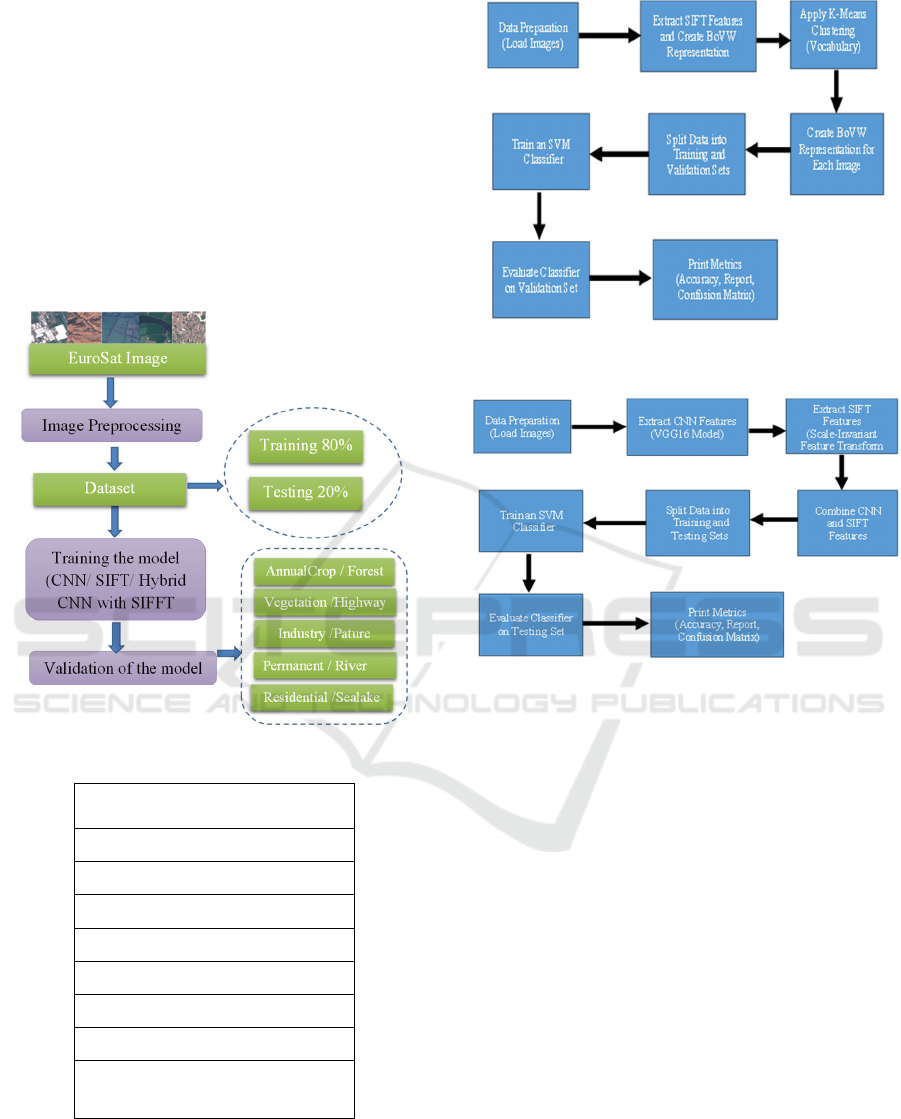
descriptors. To this end, we compare the fusion of
CNN-SIFT features to the cases where SIFT and
CNN are used separately. The framework of the
proposed models is shown in Figure1. It is worth
noting that to gain a more comprehensive
understanding of the isolated impact of the fusion
approach without any additional considerations or
optimizations, we opted for a basic SIFT-based model
and a straightforward CNN architecture for feature
extraction. While we acknowledge that more complex
CNN architectures, such as those used in (Patrick
Helber et al., 2019) and (Dewangkoro & Arymurthy,
2021), have the potential to further improve
predictive performance, such complex architectures
make it difficult to quantify the specific advantages
gained from incorporating SIFT-based descriptors.
The three models that we study are presented in the
sequel.
3.1 Model 1: CNN-Based Remote
Sensing Image Classification
The architectural components of the explored CNN
model are depicted in Figure 2. The model
incorporates two convolutional layers to capture
essential image features. The initial convolutional
layer operates on input images with dimensions of
(64, 64, 3) and employs 32 filters with Rectified
Linear Unit (ReLU) activation functions, each having
a size of 3x3. This layer effectively extracts
fundamental characteristics from the input data. The
output features from the first layer are further refined
by a second convolutional layer, consisting of 64
filters, each with a size of 3x3. The model integrates
two max-pooling layers for spatial dimension
reduction. The first max-pooling layer reduces the
spatial dimensions of the feature maps by a factor of
two, enhancing computational efficiency. The second
max-pooling layer further compresses the spatial
dimensions, facilitating more abstract feature
extraction. A flattened layer precedes the fully
connected layers, transforming the 2D feature maps
into a 1D vector. The network architecture comprises
also two dense layers, with the first layer housing 128
neurons activated by ReLU. This configuration
allows the model to learn intricate representations
from the data. For multi-class classification tasks, the
final layer encompasses ten neurons, utilizing the
SoftMax activation function to generate class
probabilities. During training, we employ the Adam
optimizer and a sparse categorical cross-entropy loss
function to optimize the model. The primary
objective is to minimize the loss and ensure accurate
categorization through the training process. "Rather
than training the investigated CNN model from
scratch, we employ transfer learning and use a pre-
trained model with weights acquired from the
ImageNet dataset (Abou Baker et al., 2022) .
3.2 Model 2: SIFT-Based Remote
Sensing Image Classification
The different steps of the second studied approach are
illustrated in Figure 3. The first step involves the
conversion of the original satellite images into
grayscale format, simplifying the data while retaining
essential visual characteristics. Following this
conversion, the SIFT algorithm is applied to identify
key points and extract local feature descriptors. These
SIFT descriptors represent distinctive image regions
and are crucial for capturing unique visual patterns.
To further streamline the feature representation and
enable efficient classification, we adopt the Bag-of-
Visual-Words (BoVW). Here, the extracted SIFT
descriptors are quantized into visual words, reducing
the feature dimensionality and forming the basis for
image representation. The quantization process is
facilitated by k-means clustering, which groups
similar descriptors into clusters, and the cluster
centers become the visual words. Finally, we employ
a Support Vector Machine (SVM) model to train on
the BoVW-represented satellite images.
3.3 Model 3: Fusion of SIFT and CNN
Features
This paper introduces a novel hybrid model that
synergizes the strengths of CNN-learned features
with SIFT descriptors to enhance remote sensing
image classification (Figure 4). The proposed
approach harnesses the power of the CNN to extract
high-level, semantically rich features, providing a
global understanding of the image. It also employs the
SIFT detector (Open CV SIFT) to capture fine-
grained, local details, benefiting from its robustness
to various transformations (e.g. scale and rotation).
The SIFT features are flattened and have lengths
that are either zero-padded or truncated to 128. To
extract deep features, we leverage a pre-trained CNN
architecture with weights sourced from ImageNet.
The base model is modified by excluding the final
fully connected layers (i.e. Include top=False),
retaining only the convolutional layers. The input
images, which are initially of varying dimensions, are
pre-processed and resized to meet the (224, 224, 3)
input shape requirement of the CNN model.
Once the SIFT and the CNN features are
generated, a unified feature vector is produced by
A Fusion Approach for Enhanced Remote Sensing Image Classification
557
horizontally stacking the CNN features with the
truncated/flattened SIFT features. Each image is
represented by this feature vector combination, which
is a rich representation, encapsulating both global and
local information. For the task of classification, we
employ a straightforward Support Vector Machine
(SVM) with a radial basis function (RBF) kernel. The
RBF kernel's flexibility enables the model to capture
complex decision boundaries in the feature space. As
demonstrated in our experimental study, this synergy
between deep learning-based features from the CNN
a conventional computer vision characteristic from
SIFT yields enhanced classification performance.
Figure 1: Frame Work for the proposed model.
Input (64x64x3 Image
Data)
Conv2D (32) 3x3,ReLU
MaxPooling 2x2
Conv2D (64) 3x3, ReLU
MaxPooling 2x2
Flatten
Dense (128) | ReLU
Dense (10) Softmax
Output (10 classes)
Figure 2: Proposed CNN architecture for classification
Remote sensing images.
Figure 3: Proposed SIFT procedure for classification
Remote Sensing Images.
Figure 4: Proposed Hybrid CNN with SIFT models.
4 EXPERIMENTAL STUDY
The EuroSAT dataset (Patrick Helber et al., 2019)
used in our experiments, is openly and freely provided
by the Copernicus Earth observation program. The
dataset is generated with 27,000 labeled and
georeferenced image patches, where the size of each
image patch is 64_64 m. To ech of the 10 classes of
the dataset corresponds 2000 to 3000 images. The
LULC classes in this dataset are permanent crop,
annual crop, pastures, river, sea & lake, forest,
herbaceous vegetation, industrial building, highway
and residential building (Patrick Helber et al., 2019).
In our experiments, 80% of the dataset was
allocated for training, while the remaining instances
were reserved for testing. The studied CNN
architecture was implemented using Tensorflow (Yu
et al., 2019) and Keras (Lee & Song, 2019). OpenCV
(Culjak et al., 2012) was used for SIFT features
generation. All methods were run using their default
settings, and no special tuning was done.
VISAPP 2024 - 19th International Conference on Computer Vision Theory and Applications
558
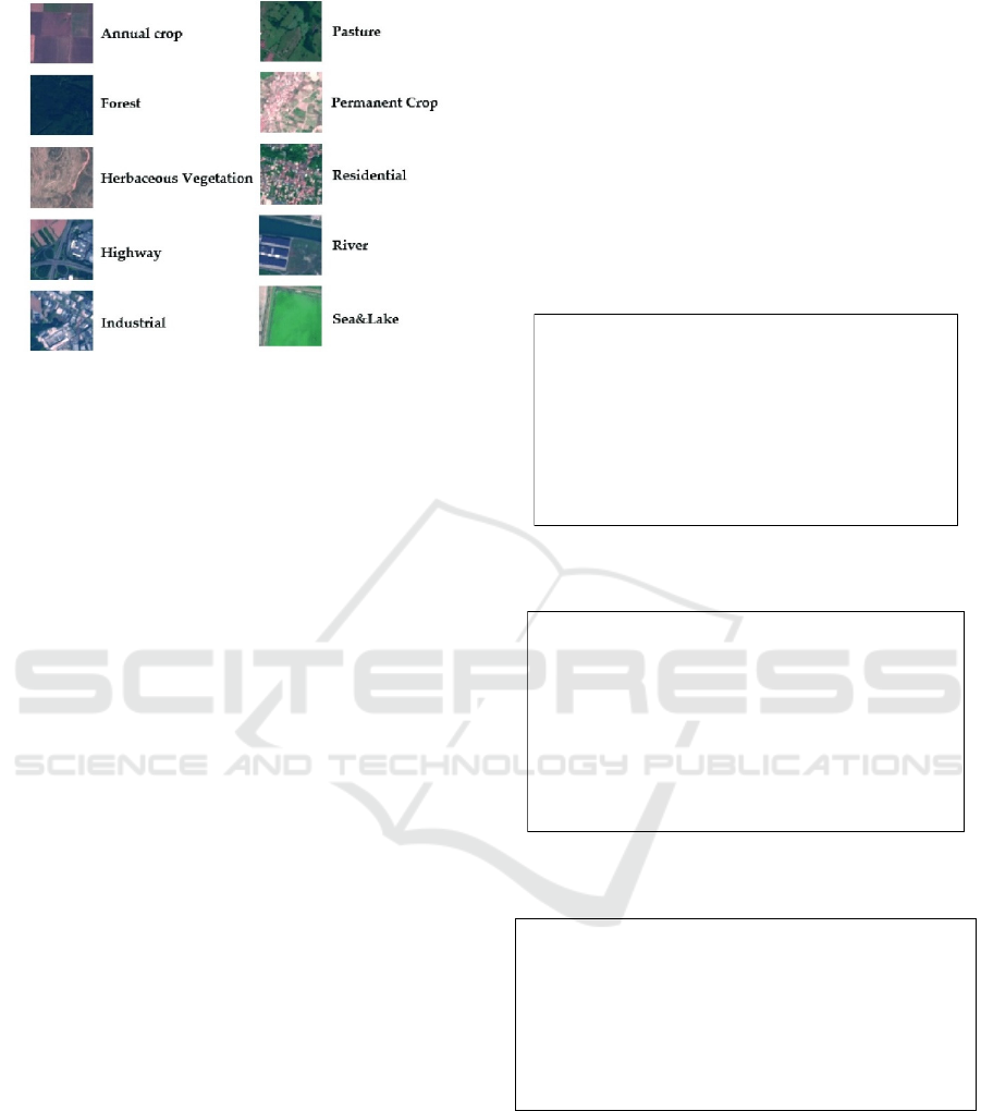
Figure 5: Sample images of Eurosat dataset ( Helber et al.,
2019).
The primary goal of our study is to bring to light the
advantages that can be drawn from combining SIFT
and CNN features. We then compare and contrast
three different remote sensing classification models:
CNN-based, SIFT-based, and a fusion approach
combining SIFT and CNN features. Figures 6, 7, 8, 9,
10 and 11 illustrate, respectively, the confusion
matrix and the detailed classification report of the
CNN-based model (Model 1), The SIFT-based model
(Model 2) and the model based on a fusion of CNN
and SIFT features (Model 3). Table 4.1. provides the
overall accuracy of the different models. As shown in
these figures and in Table 4.1, the features fusion
approach by far outperforms the SIFT-based model
and the CNN-based model, allowing an enhancement
of accuracy of 64.29% and 84.10% respectively.
Table 4.2 compares the accuracy results of our
models with some of notable existing approaches. As
shown in Table 4.2 our approach achieves an overall
accuracy of 92%, and, except for the approach
presented in (Dewangkoro & Arymurthy, 2021), it
outperforms all other models. The "BoVW (SVM,
SIFT, k = 500)" model, based on BoVW with SVM
and SIFT, achieves an overall accuracy of 70%. The
"UFL" model achieves an overall accuracy of 90%,
demonstrating the effectiveness of unsupervised
feature learning. The "Pyramid of Spatial Relations"(
Chen & Tian, 2015) model reaches 89% accuracy,
emphasizing the importance of capturing spatial
relationships. The approach presented in
(Dewangkoro & Arymurthy, 2021) uses different
CNN architectures for feature extraction, namely
VGG19, ResNet50, and InceptionV3, and achieves an
accuracy of 94%. The approach (Dewangkoro &
Arymurthy, 2021) inherits the advantages and
limitations of deep neural architectures. Our approach
achieves comparable performance to that of
(Dewangkoro & Arymurthy, 2021) while being less
resource-intensive and less reliant on the availability
of massive labelled data.
As mentioned earlier, in order to better understand
the impact of the fusion approach in isolation, we
implemented a basic SIFT-based model and a simple
CNN architecture for feature extraction. However, it
is worth noting the use in our approach of more
sophisticated CNN architectures, such as those used
in (Helber et al., 2019) and (Dewangkoro &
Arymurthy, 2021), have the potential to further
enhance predictive performance.
Figure 6: Confusion Matrix for CNN model for remote
sensing images classification.
Figure 7: Precision, Recall, F1-Score for CNN model for
remote sensing images classification.
Figure 8: Precision, Recall, F1-Score for SIFT model for
remote sensing images classification.
[[526 2 16 13 0 15 16 0 4 3]
[ 0 577 2 0 0 21 0 0 1 5]
[ 6 3 479 16 3 8 71 10 5 1]
[ 16 0 23 358 6 11 42 14 45 0]
[ 0 0 10 41 396 0 7 38 1 0]
[ 15 5 20 13 0 350 8 0 9 3]
[ 23 0 54 33 1 9 345 2 6 0]
[ 0 0 14 9 3 0 6 565 0 0]
[ 37 12 13 84 1 13 6 3 320 1]
[ 4 4 1 1 0 3 0 0 7 586]]
precision recall f1-score support
0 0.84 0.88 0.86 595
1 0.96 0.95 0.95 606
2 0.76 0.80 0.78 602
3 0.63 0.70 0.66 515
4 0.97 0.80 0.88 493
5 0.81 0.83 0.82 423
6 0.69 0.73 0.71 473
7 0.89 0.95 0.92 597
8 0.80 0.65 0.72 490
9 0.98 0.97 0.97 606
precision recall f1-score support
AnnualCrop 0.65 0.71 0.68 520
Forest 0.00 0.00 0.00 66
HerbaceousVegetation 0.40 0.36 0.38 461
Highway 0.53 0.45 0.49 483
Industrial 0.74 0.86 0.79 527
Pasture 0.28 0.65 0.40 244
PermanentCrop 0.51 0.41 0.45 483
Residential 0.77 0.78 0.78 592
River 0.42 0.29 0.35 458
SeaLake 0.00 0.00 0.00 54
A Fusion Approach for Enhanced Remote Sensing Image Classification
559

Figure 9: Confusion Matrix for SIFT model for remote
sensing images classification.
Figure 10: Precision, Recall, F1-Score for Hybrid CNN
with SIFT model for remote sensing images classification.
Figure 11: Confusion Matrix for Hybrid CNN with SIFT
model for remote sensing images classification.
Table 4.1: The results of accuracy for the proposed models.
Accurac
y
Model
0.83CNN
0.56SIFT
0.92Fusion of CNNs and SIFT features
Table 4.2: The accuracy Result of the proposed model
compare with related work.
Accurac
y
Models
0.87CNN two laye
r
( Helber et al., 2018)
0.70 BoVW (SVM, SIFT, k = 500) ( Helber et
al., 2018
)
0.90UFL (Hu et al., 2014)
0.89 Pyramid of spatial relatons( Chen & Tian,
2015)
0.94 Combination of different CNNs deep
architectures (Dewangkoro & Arymurthy,
2021)
0.92 Fusion of CNNs and SIFT features
(p
ro
p
osed model
)
5 CONCLUSION AND FUTURE
WORK
5.1 Conclusion
Remote sensing image classification is a crucial task
for various critical applications, including land cover
mapping, environmental monitoring, and disaster
response. In this work we investigated the fusion of
hand-crafted features (SIFT) and CNN-learned
features to enhance remote sensing image
classification. SIFT excels in capturing local features
essential for discerning specific image attributes.
Meanwhile, CNNs' ability to learn global context and
hierarchical features, enhances generalization and
allows accurate classification of scenes with complex
patterns. The experimental study conducted over the
EuroSAT dataset shows that our fusion approach
allows a substantial classification enhancement with
regards to CNN and SIFT used separately: up to
10.84% accuracy enhancement when compared to
CNN and up to 64.29% enhancement when compared
to SIFT. Although our fusion approach was
implemented using straightforward SIFT-based
Model and CNN architecture (to better isolate the
benefits of features fusion), our experimental study
shows that it achieves better or comparable results
with notable existing remote sensing image
classification approaches.
5.2 Future Work
The promising obtained results pave the way for the
exploration of other applications and further forms of
collaboration between classical hand-crafted features
and modern deep features. We are currently exploring
two research directions. The first involves remote
sensing images enhancement during registration,
which aims at improving the quality of remote
sensing images to make them more amenable to
subsequent analysis. The second focuses on the
detection of changes in images captured within the
same geographic areas but at different time points.
Such change detection is crucial several critical in
domains such as environmental monitoring. To this
end we are currently investigating the integration of
SIFT and Siamese networks for efficient change
detection in remote sensing image.
[[371 0 20 15 0 67 12 0 35 0]
[ 2 0 5 0 0 57 0 0 2 0]
[ 21 1 167 29 39 100 51 24 29 0]
[ 46 0 36 216 25 20 56 23 61 0]
[ 2 0 3 15 454 0 21 30 2 0]
[ 25 0 28 2 0 159 6 13 11 0]
[ 30 0 59 39 69 35 198 28 25 0]
[ 2 0 34 17 27 24 14 464 10 0]
[ 66 0 57 73 3 73 34 17 135 0]
[ 7 0 7 1 0 26 0 1 12 0]]
precision recall f1-score support
AnnualCrop 0.91 0.97 0.94 534
Forest 0.88 0.93 0.90 69
HerbaceousVegetation 0.89 0.90 0.89 473
Highway 0.90 0.87 0.89 479
Industrial 0.93 0.96 0.94 512
Pasture 0.93 0.90 0.91 251
PermanentCrop 0.90 0.87 0.88 486
Residential 0.97 0.97 0.97 591
River 0.91 0.88 0.89 441
SeaLake 0.96 0.88 0.92 52
[[516 1 4 1 0 2 5 0 4 1]
[ 0 64 1 0 0 3 0 0 1 0]
[ 2 2 425 7 5 0 20 7 5 0]
[ 12 2 2 418 5 4 9 2 24 1]
[ 0 0 1 6 489 0 7 9 0 0]
[ 5 3 11 0 0 225 4 0 3 0]
[ 16 0 28 6 11 1 422 1 1 0]
[ 0 1 3 0 12 0 1 574 0 0]
[ 13 0 3 27 1 7 2 0 388 0]
[ 3 0 0 0 0 1 0 0 2 46]]
VISAPP 2024 - 19th International Conference on Computer Vision Theory and Applications
560

REFERENCES
Abou Baker, N., Zengeler, N., & Handmann, U. (2022). A
Transfer Learning Evaluation of Deep Neural Networks
for Image Classification. In Machine Learning and
Knowledge Extraction (Vol. 4, Issue 1,pp. 22–41).
https://doi.org/10.3390/make4010002
Aksoy, M. Ç., Sirmacek, B., & Ünsalan, C. (2023). Land
classification in satellite images by injecting traditional
features to CNN models. Remote Sensing Letters,
14(2), 157–167. https://doi.org/10.1080/2150704X.
2023.2167057
Chen, S., & Tian, Y. (2015). Pyramid of Spatial Relatons
for Scene-Level Land Use Classification. IEEE
Transactions on Geoscience and Remote Sensing,
53(4), 1947–1957. https://doi.org/10.1109/TGRS.
2014.2351395
Cheng, G, Xie, X., Han, J., Guo, L., & Xia, G.-S. (2020).
Remote Sensing Image Scene Classification Meets
Deep Learning: Challenges, Methods, Benchmarks,
and Opportunities. IEEE Journal of Selected Topics in
Applied Earth Observations and Remote Sensing, 13,
3735–3756. https://doi.org/10.1109/JSTARS.2020.
3005403
Cheng, Gong, Xie, X., Han, J., Guo, L., & Xia, G. S. (2019).
Remote Sensing Image Scene Classification Meets
Deep Learning: Challenges, Methods, Benchmarks,
and Opportunities. IEEE Journal of Selected Topics in
Applied Earth Observations and Remote Sensing,
13(X), 37353756. https://doi.org/10.1109/JSTARS.
2020.3005403
Culjak, I., Abram, D., Pribanic, T., Dzapo, H., & Cifrek, M.
(2012). A brief introduction to OpenCV. 2012
Proceedings of the 35th International Convention
MIPRO, 1725–1730.
Dewangkoro, H. I., & Arymurthy, A. M. (2021). Land use
and land cover classification using CNN, SVM, and
Channel Squeeze & Spatial Excitation block. IOP
Conference Series: Earth and Environmental Science,
704(1). https://doi.org/10.1088/1755-1315/704/1/012
048
Helber, P, Bischke, B., Dengel, A., & Borth, D. (2018).
Introducing Eurosat: A Novel Dataset and Deep
Learning Benchmark for Land Use and Land Cover
Classification. IGARSS 2018 - 2018 IEEE International
Geoscience and Remote Sensing Symposium, 204–207.
https://doi.org/10.1109/IGARSS.2018.8519248
Helber, Patrick, Bischke, B., Dengel, A., & Borth, D.
(2019). Eurosat: A novel dataset and deep learning
benchmark for land use and land cover classification.
IEEE Journal of Selected Topics in Applied Earth
Observations and Remote Sensing, 12(7), 2217–2226.
https://doi.org/10.1109/JSTARS.2019.2918242
Hu, F., Xia, G.-S., Wang, Z., Zhang, L., & Sun, H. (2014).
Unsupervised feature coding on local patch manifold
for satellite image scene classification. 2014 IEEE
Geoscience and Remote Sensing Symposium, 1273–
1276. https://doi.org/10.1109/IGARSS.2014.6946665
Janga, B., Asamani, G. P., Sun, Z., & Cristea, N. (2023). A
Review of Practical AI for Remote Sensing in Earth
Sciences. In Remote Sensing (Vol. 15, Issue 16).
https://doi.org/10.3390/rs15164112
Lee, H., & Song, J. (2019). Introduction to convolutional
neural network using Keras; an understanding from a
statistician. Communications for Statistical
Applications and Methods, 26(6), 591–610.
Temenos, A., Temenos, N., Kaselimi, M., Doulamis, A., &
Doulamis, N. (2023). Interpretable Deep Learning
Framework for Land Use and Land Cover
Classification in Remote Sensing Using SHAP. IEEE
Geoscience and Remote Sensing Letters, 20, 1–5.
https://doi.org/10.1109/LGRS.2023.3251652
Thakur, R., & Panse, P. (2022). Classification Performance
of Land Use from Multispectral Remote Sensing
Images using Decision Tree, K-Nearest Neighbor,
Random Forest and Support Vector Machine Using
EuroSAT. nternational Journal of Intelligent Systems
and Applications in Engineering IJISAE, 2022(1s),67–
77. https://github.com/phelber/EuroSAT
Tsourounis, D., Kastaniotis, D., Theoharatos, C.,
Kazantzidis, A., & Economou, G. (2022). SIFT-CNN:
When Convolutional Neural Networks Meet Dense
SIFT Descriptors for Image and Sequence
Classification. Journal of Imaging, 8(10).
https://doi.org/10.3390/jimaging8100256
Wang, X., Xu, H., Yuan, L., Dai, W., & Wen, X. (2022). A
Remote-Sensing Scene-Image Classification Method
Based on Deep Multiple-Instance Learning with a
Residual Dense Attention ConvNet. In Remote Sensing
(Vol. 14, Issue 20). https://doi.org/10.3390/rs14205095
Weinzaepfel, P., Jégou, H., & Pérez, P. (2011).
Reconstructing an image from its local descriptors.
Proceedings of the IEEE Computer Society Conference
on Computer Vision and Pattern Recognition, 337–344.
https://doi.org/10.1109/CVPR.2011.5995616
Weiss, M., Jacob, F., & Duveiller, G. (2020). Remote
sensing for agricultural applications: A meta-review.
Remote Sensing of Environment, 236, 111402.
https://doi.org/https://doi.org/10.1016/j.rse.2019.11140
2
Yaloveha, V., Podorozhniak, A., Kuchuk, H., &
Garashchuk, N. (2023). Performance Comparison of
Cnns on High-Resolution Multispectral Dataset
Applied To Land Cover Classification Problem.
Radioelectronic and Computer Systems, 2023(2(106)),
107–118. https://doi.org/10.32620/REKS.2023.2.09
Yu, L., Li, B., & Jiao, B. (2019). Research and
Implementation of CNN Based on TensorFlow. IOP
Conference Series: Materials Science and Engineering,
490, 42022. https://doi.org/10.1088/1757-899X/490/
4/042022.
A Fusion Approach for Enhanced Remote Sensing Image Classification
561
