
Big Data Synthesis and Class Imbalance Rectification for Enhanced
Forest Fire Classification Modeling
Fatemeh Tavakoli
1 a
, Kshirasagar Naik
1 b
, Marzia Zaman
2 c
, Richard Purcell
3 d
,
Srinivas Sampalli
3 e
, Abdul Mutakabbir
4 f
, Chung-Horng Lung
4 g
and Thambirajah Ravichandran
5 h
1
Department of Electrical and Computer Engineering, University of Waterloo, Waterloo, ON, Canada
2
Research and Development, Cistel Technology, Ottawa, ON, Canada
3
Faculty of Computer Science, Dalhousie University, Halifax, NS, Canada
4
Department of Systems and Computer Engineering, Carleton University, Ottawa, ON, Canada
5
Research and Development, Hegyi Geomatics International Inc., Ottawa, ON, Canada
Keywords:
Forest Fire, Classification, Machine Learning, Supervised Learning, Dataset, Big Data, Random Forest,
XGBoost, LightGBM, SMOTE, NearMiss, SMOTE-ENN.
Abstract:
Forest fires have been escalating in frequency and intensity across Canada in recent times. This study em-
ploys machine learning techniques and builds a dataset framework utilizing Copernicus climate reanalysis
data combined with historical fire data to develop a fire classification framework. Three algorithms, Random
Forest, XGBoost, and LightGBM, were evaluated. Given the pronounced class imbalance of 154:1 between
“non-fire” and “fire” events, we rigorously employed two re-sampling strategies: Spatiotemporal, focusing on
spatial and seasonal considerations, and Technique-Driven, leveraging advanced algorithmic approaches. Ul-
timately, XGBoost combined with NearMiss Version 3 in a 0.09 sampling ratio between “non-fire” and “fire”
events yielded the best results: 98.08% precision, 86.06% sensitivity, and 93.03% specificity.
1 INTRODUCTION
The increasing prevalence of forest fires poses a sub-
stantial threat to both ecological systems and hu-
man communities. This challenge is magnified by
contributing factors such as climate change, anthro-
pogenic activities, and constrained preventive and
management measures. A recent study reveals that
the global tree cover loss attributed to forest fires has
nearly doubled in the past two decades (Tyukavina
et al., 2022). Specifically in Canada, an alarming 9.5
million hectares were burned in just the first seven
months of 2023, highlighting the severity of the prob-
a
https://orcid.org/0009-0008-9734-6417
b
https://orcid.org/0000-0002-1064-4905
c
https://orcid.org/0000-0002-0610-0470
d
https://orcid.org/0009-0005-1526-8338
e
https://orcid.org/0000-0002-8742-5786
f
https://orcid.org/0009-0004-9850-8239
g
https://orcid.org/0000-0002-5662-490X
h
https://orcid.org/0000-0002-3579-2832
lem (Canadian Interagency Forest Fire Centre, 2023).
Amid these challenges, Machine Learning (ML)
emerges as a robust solution. With its capability to
dissect intricate datasets and adapt to swift environ-
mental changes, it holds promise for transformative
forest fire management. Applications of ML in this
domain encompass:
• Early Detection: Analyzing satellite and sensor
data for preliminary fire indications.
• Predictive Analysis: Employing historical
weather and vegetation data to predict forest fire
probabilities in specific regions.
• Resource Allocation: Strategically allocating
firefighting resources based on past fire incidents
and resource availability.
• Post-Fire Analysis: Quantifying the environmen-
tal ramifications of fires and forecasting the nec-
essary recovery durations.
Building upon the predictive potential of ML, this
study introduces an ML-based framework for forest
fire classification. Utilizing Copernicus climate data,
264
Tavakoli, F., Naik, K., Zaman, M., Purcell, R., Sampalli, S., Mutakabbir, A., Lung, C. and Ravichandran, T.
Big Data Synthesis and Class Imbalance Rectification for Enhanced Forest Fire Classification Modeling.
DOI: 10.5220/0012363000003636
Paper published under CC license (CC BY-NC-ND 4.0)
In Proceedings of the 16th International Conference on Agents and Artificial Intelligence (ICAART 2024) - Volume 2, pages 264-275
ISBN: 978-989-758-680-4; ISSN: 2184-433X
Proceedings Copyright © 2024 by SCITEPRESS – Science and Technology Publications, Lda.
we differentiate “fire” and “non-fire” incidents, em-
phasizing the role of ML in predictive analysis for for-
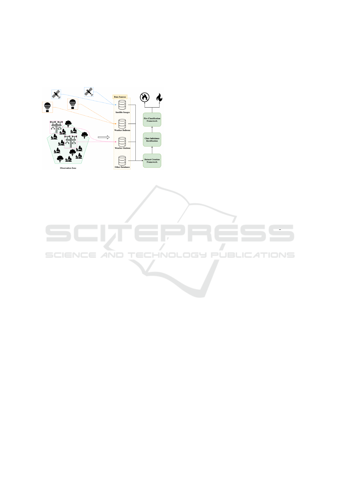
est fire management. Figure 1 presents the proposed
system model with its key contributions.
Figure 1: Proposed system model.
This research offers significant contributions to
the field of forest fire predictive analysis in the fol-
lowing three primary areas.
C1 Dataset Creation Framework: To address the
need for comprehensive forest fire datasets, we
assembled a unique dataset comprising 27 vari-
ables from various sources. A pivotal source
is the Copernicus re-analysis climate data (Hers-
bach et al., 2023), which integrates multiple data
sources to offer a comprehensive record of his-
torical climate conditions, some of which are
presented in Figure 1. Other sources include
the Canadian Wildland Fire Information Sys-
tem (CWFIS) Datamart (Service, 2022), Statis-
tics Canada (Statistics Canada, 2021), and Ar-
cGIS RESET (Saskatchewan Government, 2022).
This multi-source dataset is instrumental in eval-
uating ML models and bridges knowledge gaps,
promoting more nuanced research and practical
applications.
C2 Class Imbalance Rectification: Given the 154:1
class imbalance between “non-fire” and “fire”
events, we employed two re-sampling strategies.
The ratio was calculated by dividing the num-
ber of “non-fire” events by the number of “fire”
events.
i. Spatiotemporal Resampling: A focus on spa-
tial and seasonal relevance to fires.
ii. Technique-Driven Resampling: Leveraging
NearMiss Version 3 (NearMiss3), Synthetic
Minority Over-sampling Technique (SMOTE),
as well as its variant combined with Edited
Nearest Neighbors (ENN) — termed (SMOTE-
ENN) — for balanced event representation.
These strategies enhanced our dataset’s robust-
ness against the prevailing class imbalance.
C3 Fire Classification Framework: We devised a
specialized ML framework for the classification
of forest fires. In this context, forest fire classifi-
cation refers to the categorization of a given ge-
ographical region or dataset into “fire” or “non-
fire” based on certain environmental and climatic
features. Let F represent the feature set for forest
fire classification, defined as:
F = {T,SW, E,R,W,P,Pr,V }
where:
T : Temperature
SW : Soil Water
E : Evaporation
R : Runoff
W : Wind
P : Pressure
Pr : Precipitation
V : Vegetation
Given the feature set F defined above, our dataset
comprises these eight primary categories. They
collectively contribute to 22 specific environmen-
tal and climatic features. Additional columns in
the dataset represent the day of the year, year of
fire, latitude, longitude, and a coordinate ID, cul-
minating in a total of 27 columns. In predictive
modeling for complex events like forest fires, em-
ploying a model with a broad array of features
enhances the precision and performance in distin-
guishing between “fire” and “non-fire” events by
providing a comprehensive analysis.
This framework employs widely-used algorithms,
including Random Forest (RF), Extreme Gradient
Boosting (XGBoost), and Light Gradient Boost-
ing Machine (LightGBM). It has been rigorously
tested on unseen data to ascertain its real-world
applicability and generalizability.
To conduct experiments and demonstrate contri-
bution C1, a dataset was collected for the province
of Saskatchewan, Canada, spanning the years 2000–
2018. Data sources include Copernicus Reanaly-
sis Climate data, CWFIS Datamart, the provincial
boundary shapefile provided by Statistics Canada, and
provincial water body information provided by Ar-
cGIS RESET. This effort yielded a total of 4,714,983
raw data points, which will be explained further in
Section 3. For contributions C2 and C3, a joint
methodology is presented in Section 4.
In managing class imbalance in fire detection, the
NearMiss3 method with a 0.09 sampling ratio proved
pivotal. This led the RF model to achieve 78.3%
accuracy, 74.8% sensitivity, and 78.3% specificity.
Big Data Synthesis and Class Imbalance Rectification for Enhanced Forest Fire Classification Modeling
265

However, XGBoost, when combined with NearMiss3
at a 0.09 ratio, stood out with 98.08% accuracy,
86.06% sensitivity, and 93.03% specificity. Light-
GBM reported 72.38% accuracy, 76.03% sensitivity,
and 72.36% specificity.
The paper is organized as follows: Section 2 dis-
cusses relevant literature on data methods, imbal-
ance techniques, and ML models. Section 3 covers
data collection. Section 4 describes the modeling ap-
proach. Results are presented in Section 5, and Sec-
tion 6 concludes with future directions.
2 LITERATURE REVIEW
The domain of forest fire prediction has seen rapid
advancements, with researchers adopting varied data
collection methods, addressing dataset imbalances,
and employing advanced machine learning tech-
niques. This section provides a comprehensive
overview of these developments, pinpointing areas of
consensus and highlighting future research directions.
2.1 Data Collection Methods
Data collection is pivotal for the development of ef-
fective ML models in forest fire detection. Numerous
techniques have been explored, ranging from satel-
lite imagery, remote sensing, and Internet of Things
(IoT) deployments to the use of weather stations, Un-
manned Aerial Vehicles (UAVs), ground sensors, his-
torical records, and crowd-sourced data. A compre-
hensive overview of these methods and the corre-
sponding studies can be found in Table 1.
Rather than conducting primary data collection,
several studies prefer to utilize existing datasets.
Prominent examples are the UC Irvine ML repository
dataset from Portugal (Cortez and Morais, 2007), (El-
sarrar et al., 2019) and the SaskFire for time-series
classification (Laube and Hamilton, 2021). Moreover,
Kaggle datasets have played a crucial role in research,
as seen in studies like (Preeti et al., 2021).
In our study, we utilize the Copernicus reanaly-
sis data, valued for its comprehensive coverage, high
temporal resolution, and absence of missing data, en-
suring a robust foundation for accurate forest fire pre-
dictions with our ML models.
2.2 Imbalance Dataset
ML’s application to forest fire prediction often grap-
ples with the challenge of data imbalance. A con-
siderable portion of existing research, such as (Bui
et al., 2018), (Li et al., 2020), and (Hong et al., 2018),
employs an equal 1:1 distribution of fire and non-fire
data points. This approach, while simplifying analy-
sis, might not accurately represent the natural dispar-
ity observed in real-world fire incidents. Such dis-
crepancies can compromise the applicability of de-
rived predictive models in practical scenarios (Kaur
et al., 2023).
Some studies acknowledge the imbalance issue
but often settle for predefined ratios, like 3:1 or 10:1.
Others defer addressing the problem, relegating it to
sections on future work. Addressing this gap (Mu-
takabbir et al., 2023b), the Spatio-Temporal Agnostic
Subsampling (STAS) framework has been introduced
as an innovative approach to manage data imbalance
in forest fire prediction (Mutakabbir et al., 2023a).
In our research, we strive to address this oversight
by emphasizing the significance of Spatiotemporal re-
sampling, focusing on the spatial and seasonal pat-
terns of fire events. Additionally, our methodology
incorporates advanced re-sampling techniques to en-
sure a balanced and accurate representation of events
in the data.
2.3 ML Models in Forest Fire
Forest fire modeling has transitioned from traditional
statistical methods to advanced ML techniques. Ini-
tial models focused on logistic regression and deci-
sion trees, evolving to neural networks and ensemble
methods for more effective fire dynamics prediction
(Safi and Bouroumi, 2013). Ensemble methods, par-
ticularly RF and Gradient Boosting, are noted for their
robust predictive capabilities through model aggrega-
tion (Rodriguez-Galiano et al., 2012). Time-series
analyses, especially with Long Short-Term Memory
(LSTM), have proven effective in addressing the se-
quential nature of forest fire data (Natekar et al.,
2021). A survey of literature from 2014 to 2022 iden-
tified 38 pertinent studies on IEEE Xplore, reflecting
a trend from RF and SVM towards more complex al-
gorithms like gradient boosting and LSTM (Purcell
et al., 2023).
Despite deep learning’s increasing application for
its predictive accuracy as seen in (Mutakabbir et al.,
2023a), our study opts for ML strategies that offer
computational efficiency and enhanced interpretabil-
ity in managing imbalanced datasets.
3 DATASET CREATION
FRAMEWORK
This section introduces the processes undertaken to
gather a dataset suitable for predicting forest fires us-
ICAART 2024 - 16th International Conference on Agents and Artificial Intelligence
266
Table 1: Forest Fire Data Collection Methods.
References Method Method Description
(Preeti et al., 2021),
(Ghate et al., 2023)
Satellite Imagery Utilizing satellite sensors to capture images of forests and ana-
lyze them for fire detection.
(Ali et al., 2022),
(Hidayanto et al., 2021),
(Kosovi
´
c et al., 2020)
Remote Sensing Using remote sensing technologies, such as LiDAR or infrared
sensors, to collect data on vegetation health, temperature, and
other relevant factors.
(Suklabaidya and Das,
2023),
(Zope et al., 2020),
(Hidayanto et al., 2021)
IoT sensors Deploying IoT sensors in forested areas to collect environmental
data, such as temperature, humidity and air quality.
(Omar et al., 2021) Weather Stations Deploying weather stations in or near forested areas to collect
real-time weather data, including temperature, humidity, wind
speed, and precipitation.
(Sudhakar et al., 2020) UAVs Using drones equipped with cameras and sensors to capture
high-resolution images and collect data in fire-prone areas.
(Sudhakar et al., 2020) Ground-Based Sen-
sors
Installing ground-based sensors, such as temperature and mois-
ture sensors, to monitor forest conditions and detect anomalies.
(Singh et al., 2019),
(Tayal et al., 2022)
Historical Fire
Records
Analyzing historical fire records and incorporating them into the
dataset for model training and validation.
(Sudhakar et al., 2020) Crowd-Sourced Data Gathering data from crowd-sourced platforms where volun-
teers contribute fire-related information, including fire incidents,
burned areas, and fire severity assessments.
ing ML techniques. Data gathering plays a pivotal
role as it marks the initial step towards predicting ig-
nition points in forests. Several factors thought to in-
fluence forest fire were considered. These common
factors include humidity, temperature, surface pres-
sure, and precipitation. Although various papers have
proposed datasets considering one or two of these fac-
tors, our work encompasses a broader array of fea-
tures to enhance the relationship between these ele-
ments when building ML models.
Figure 2 illustrates the proposed dataset creation
framework. Subsequent sections provide a compre-
hensive insight into its implementation and discuss
the generation of the Saskatchewan dataset, tailored
for our forest fire prediction research. This frame-
work is versatile enough to accommodate data from
various provinces or geographic regions. Within this
dataset, “fire” points are represented by 1, and “non-
fire” points by 0.
Four primary data sources underpin this frame-
work, as shown in Figure 2: meteorological data (re-
ferred to as cmet src), provincial boundary file (re-
ferred to as bound src), historical fire data (referred
to as fire src), and water bodies file (referred to as
water src). Both the meteorological data and the
historical fire data are expected to encompass coordi-
nates and date information. Moreover, the historical
fire dataset should offer details about the fire’s mag-
nitude and origin.
The provincial boundary file and the water bodies
file, both provided in shapefile format, play specific
Figure 2: Dataset Creation Framework.
roles in the data processing:
• Provincial Boundary File: This file defines the
limits of a predetermined area, effectively tailor-
ing the dataset to the desired region. After speci-
Big Data Synthesis and Class Imbalance Rectification for Enhanced Forest Fire Classification Modeling
267

fying this region, it becomes possible to integrate
pertinent fire-related information. The process of
merging meteorological data with historical fire
records involves several factors. One such factor
is the scale of the affected area by the fire. The en-
tries in the “fire” column are gauged based on the
extent of the fire within a particular spatial range.
• Water Bodies File: This file is employed to re-
fine the dataset by filtering out data points that
lie within the region’s aquatic zones. Such zones
encompass lakes, seas, oceans, substantial rivers,
and large salt flats. By excluding these points,
the dataset becomes more focused, eliminating re-
gions where fires are less likely to occur.
In the following subsections, the integration of
each source into the framework and its role in pro-
ducing the final raw data is detailed.
3.1 Climate Reanalysis Data
We utilize the high-resolution European Environment
Agency (ERA)5 dataset from the Copernicus Climate
Change Service (Hersbach et al., 2023) for meteoro-
logical data retrieval. Produced by European Cen-
tre for Medium-Range Weather Forecasts (ECMWF),
this dataset has been operational since 1940, offer-
ing a three-dimensional grid of climate variables at
sub-daily intervals. Its comprehensive temporal and
spatial resolution is particularly suited for analyzing
complex interactions in climate patterns, pivotal in
forest fire risk modeling. Referred to as cmet src
in Figure 2, ERA5’s granularity supports the precise
detection of environmental phenomena essential for
prediction models.
3.1.1 Spatial Resolution
The horizontal resolution of the fixed grid is 0.25
◦
x 0.25
◦
on a regular lat-lon grid projection. To iso-
late data specific to the targeted province, the subre-
gion coordinates provided in Table 2 are taken into
account.
Table 2: Sub-Region Coordinates.
xmin ymin xmax ymax
Saskatchewan -109.99 48.99 -101.36 60.00
The retrieved files consist of 19 files in the
NetCDF format (Network Common Data Form) with
a “.nc” extension, referred to as cmet in. NetCDF
files are multidimensional scientific data files. Each
layer stores information about one of the retrieved
features, such as temperature, humidity, pressure, and
wind speed. These files have been analyzed and con-
verted to tabular data with “.csv” extensions using R
programming language (Purcell et al., 2023). The
output from the “Clip to targeted province” box in
Figure 2 is named cmet out.
3.1.2 Temporal Resolution
ERA5 provides data with an hourly temporal resolu-
tion, spanning from January 1950 up to the present.
For the purposes of this project, the focus is solely
on the data collected at 12 noon. This decision is
guided by the Canadian Fire Weather Index, which in-
dicates that noon is a critical time for predicting wild-
fire risk levels (Lawson and Armitage, 2008). The
dataset covers the period from 2000 to 2018 and in-
cludes observations for every day of each month.
3.2 Historical Fire Data Point
The historical fire data has been sourced from the
CWFIS Datamart (Service, 2022). Fire point data
from the National Fire Database consist of a collec-
tion of forest fire locations, provided by various Cana-
dian fire management agencies, including provinces,
territories, and Parks Canada.
The National Fire Database’s fire point data
shapefile, referred to as fire in in Figure 2, has been
downloaded. This shapefile contains historical fire
data for all of Canada, spanning the years 1946 to
2021. We imported this shapefile as a vector layer
into the Quantum Geographic Information System
(QGIS) and subsequently saved it as a CSV (Comma
Separated Values) file. The exported file, named
fire out, was filtered based on province and year,
selecting only records pertaining to Saskatchewan and
covering the years 2000–2018. During this process,
the dates in the YYYY-MM-DD format were con-
verted to the day of the year. Some preliminary
data cleaning was also carried out to remove data
points outside the provincial boundaries. These steps
were performed in the box labeled “Filter and Pre-
processing Data” in Figure 2, and the output file is
called fire of.
The cmet out and fire of files from the previ-
ous steps were merged, and the target column “fire”
was added using Algorithm 1. This is highlighted
in the box titled “Filter and Join on (Coordinate ID,
day)” in Figure 2. To populate the “fire” column, we
considered both the spatial resolution of the meteoro-
logical data, which was set at 0.25 degrees, and the
size of the fires. The “fire” column is populated based
on two conditions: 1) whether there are any histori-
cal fires within a given bounding box; and 2) whether
there are any within a radius calculated based on the
ICAART 2024 - 16th International Conference on Agents and Artificial Intelligence
268

fire’s size. If a fire meets either of these conditions,
the column “fire” for that particular location is set to
1; otherwise, it remains at 0. This approach helps us
identify locations that are in close proximity to histor-
ical fires.
Data: df1, df2, fire df copy, frame
Result: Updated df2 with “fire” column
indicating fire proximity
Initialize df1 from fire df copy;
Initialize df2 from frame and add “fire” column
set to 0;
foreach location in df2 do
Extract location attributes: lat, lon, doy,
year;
Filter fires from df1 by day and year into
fire df ;
foreach fire in fire df do
Extract fire attributes: LATITUDE,
LONGITUDE, SIZE HA;
Compute distance using haversine
between fire and location;
Determine if fire is within proximity
using calculated distance and fire
radius;
if fire is inside or near location then
Update “fire” attribute in df2 and
exit loop;
end
end
end
Algorithm 1: Check for Fire Proximity.
Data: lon1, lat1, lon2, lat2 (in degrees)
Result: Distance between two points in
kilometers
Function haversine(lon1, lat1, lon2, lat2)
Convert lon1, lat1, lon2, lat2 to radians;
dlon ← lon2 −lon1;
dlat ← lat2 −lat1;
a ← sin
2
(dlat/2)+ cos(lat1) ×cos(lat2) ×
sin
2
(dlon/2);
c ← 2 ×asin(
√
a);
R ← 6371 ; // R: Radius of Earth in
kilometers
return c ×R;
Algorithm 2: Calculate Distance Using Haversine For-
mula.
Algorithm 1 serves two primary functions:
1. It employs the haversine formula, as detailed in
Algorithm 2, to calculate the distance between fire
locations and meteorological data points based on
Data: lat1, lon1, lat2, lon2 (coordinates),
resolution degrees (bounding box
resolution)
Result: Boolean indicating if the coordinate is
inside the bounding box
Function is coordinate inside(lat1, lon1,
lat2, lon2, resolution degrees)
lat di f f ← |lat1 −lat2|;
lon di f f ← |lon1 −lon2|;
if lat di f f ≤ resolution degrees and
lon di f f ≤ resolution degrees then
return True;
else
return False;
end
Algorithm 3: Check if a Coordinate is Inside a Bounding
Box.
their latitude and longitude. The haversine for-
mula is specifically designed to compute distances
on a sphere, making it ideal for calculating dis-
tances on the Earth’s surface given its curvature.
This ensures a more accurate distance measure-
ment compared to simpler Cartesian calculations.
2. The algorithm checks whether each data point lies
within a square bounding box of a given resolu-
tion, as demonstrated in Algorithm 3.
Algorithm 1 gives the full overview of the process.
The objective is to find out if a certain location (given
by the latitude and longitude coordinates) is within
the vicinity of a fire event from historical data. Dur-
ing this data preprocessing phase, we filtered out rows
corresponding to periods outside of the fire seasons to
ensure that our dataset primarily captures the relevant
timeframes when forest fires are most likely to occur.
The data out file is the final output of this step.
3.3 Provincial Boundary
To isolate data specific to our targeted province,
Saskatchewan, we require a separate source for
provincial boundary information. These boundary
files provide geographic coordinates in terms of lati-
tude and longitude and portray the full extent of the
area, including any adjacent coastal water regions.
This data source is represented as bound src in work-
flow Figure 2.
For the purposes of this study, bound in file, the
2021 census boundary shapefile provided by Statis-
tics Canada was used to determine the Saskatchewan
provincial boundary.
Big Data Synthesis and Class Imbalance Rectification for Enhanced Forest Fire Classification Modeling
269
3.4 Water Body Shapefile
To refine the quality and relevance of our dataset, we
performed a second round of data extraction specifi-
cally designed to exclude water bodies from the geo-
graphical locations studied. Since water bodies, such
as, lakes, rivers, and oceans are not susceptible to
fires, their inclusion in the dataset would not provide
any meaningful insights for our predictive fire model.
These extraneous data could even introduce noise or
bias, thereby affecting the model’s accuracy.
To introduce this supplementary layer of data
cleaning, a specific shapefile, termed water in,
which contains detailed geographic information about
water bodies, was employed. Using this shapefile,
data points in data out corresponding to water bod-
ies were effectively removed. This optimization en-
hances the accuracy and relevance of analysis in sub-
sequent research stages. In Figure 2, data of repre-
sents the output file containing the finalized raw data.
3.5 Saskatchewan Dataset Summary
Data was collected annually from 2000-2018 from the
ERA5 dataset, as shown in Table 3 for Saskatchewan.
While centered on Saskatchewan, the framework, de-
tailed in Section 4, is adaptable for other locations.
The Final Raw Data, shown in Figure 2, is used as in-
put for the modeling framework depicted in Figure 3.
Table 3: Summary of Saskatchewan forest fire dataset.
Dataset Samples Features Classes
Sask Forest Fire 4,381,020 27 2
4 MODELING FRAMEWORK
In this section, we detail the modeling methodology
employed in this paper. Class imbalance in datasets
poses considerable challenges when striving for pre-
cise and robust ML models. The approach we adopt
to tackle these challenges is illustrated in Figure 3.
Within this framework, a fundamental decision cen-
ters around choosing the most suitable sampling tech-
nique. In this study, we thoroughly examine three
techniques, each addressing different facets of im-
balance correction: over-sampling, under-sampling,
and a hybrid approach. Specifically, the NearMiss3,
SMOTE, and SMOTE and ENN (SMOTE-ENN)
techniques were assessed to determine their effective-
ness in generating balanced datasets, as highlighted in
contribution C2. Upon determining the optimal sam-
pling technique using the base classifier, which is RF,
we pivot our attention to model selection and opti-
mization. We employ three classifiers: RF, XGBoost,
and LightGBM, aiming to achieve optimal classifica-
tion, as discussed in contribution C3. Subsequent sub-
sections provide a deeper understanding of each step,
illustrating the sophisticated interplay between sam-
pling and modeling within our proposed framework.
Figure 3: Modeling framework.
4.1 Modeling Overview
Figure 3 displays the modeling framework steps. The
final raw data from the Dataset Creation Framework
(see Figure 2) is first enhanced in Box 0, then split
into training and test sets in Box 1. Data is standard-
ized to ensure a consistent scale across features. Fol-
lowing this, and before addressing the class imbal-
ance in Box 2, three re-sampling techniques - over-
sampling, under-sampling, and hybrid - are evaluated.
Using RandomSearchCV within a pipeline archi-
tecture helps in determining the most effective pa-
ICAART 2024 - 16th International Conference on Agents and Artificial Intelligence
270

rameters for the chosen re-sampling technique. The
RF model serves as a benchmark to evaluate the effi-
ciency of the re-sampling, leading to the selection of
the most appropriate re-sampling method for model
fitting, as depicted in Box 3.
The model’s performance, evaluated using metrics
such as, accuracy, sensitivity, specificity, and ROC-
AUC, is detailed in Box 4. Hyperparameter tuning,
presented in Box 5, refines algorithm accuracy. The
final stage of the methodology, in Box 6, identifies
important features. By rerunning the modeling with
these key features, we assess if a simplified feature
space retains or enhances predictive power.
The study applies three ML algorithms, the whole
process is repeated three times o identify the optimal
model, represented as the last step in Box 7 of the
framework. The next subsections briefly describes
Technique-Driven re-sampling methods and model-
ing algorithms.
4.2 Re-Sampling Techniques
Re-sampling techniques, namely, NearMiss3,
SMOTE, and SMOTE-ENN. are instrumental for
refining class distributions, thereby enhancing
model performance, particularly in scenarios where
instances of the minority class hold critical signif-
icance. An essential aspect of these techniques is
the concept of the sampling strategy, interchangeably
referred to as the “sampling ratio” in our context.
The sampling strategy, often defined as a floating-
point value using the sampling strategy parame-
ter, signifies the intended proportion of samples from
the minority class relative to the majority class post-
resampling (Lema
ˆ
ıtre et al., 2017). Mathematically,
denoting the sampling strategy as α and the counts
of samples in the minority and majority classes as
N
minority
and N
majority
respectively, this relationship
can be expressed as:
α =
N
minority
N
majority
(1)
Next, we will offer concise descriptions of each
Technique-Driven re-sampling method.
4.2.1 NearMiss3
NearMiss is an under-sampling strategy designed to
reduce instances from the majority class. Of its var-
ious versions, NearMiss3 stands out. It selects ma-
jority class samples based on their distance to distant
minority class samples. In essence, it retains majority
class instances with the shortest average distance to a
specified number of the most distant minority samples
(Lema
ˆ
ıtre et al., 2017).
4.2.2 SMOTE
SMOTE is a prominent over-sampling technique that
creates synthetic samples for the minority class. It
operates by selecting two or more similar instances
in the feature space and producing a new instance
as a convex combination of the selected instances.
Through interpolation, SMOTE expands the data rep-
resentation for the minority class, aiming to balance
the class distribution (Lema
ˆ
ıtre et al., 2017).
4.2.3 SMOTE-ENN
SMOTE-ENN integrates principles of both over-
sampling and data cleaning. It begins with the
SMOTE approach to over-sample the minority class.
Subsequently, the ENN method is employed, remov-
ing majority class instances that are misclassified by
their three nearest neighbors. This dual approach not
only adds synthetic instances for balance but also re-
fines the dataset by eliminating ambiguous or extrane-
ous majority class instances (Lema
ˆ
ıtre et al., 2017).
4.3 Modeling Algorithms
Three state-of-the-art classifiers were employed to
achieve optimal classification. A concise overview of
these classifiers is as follows:
• Random Forest (RF): An ensemble method that
uses multiple decision trees. Random subsets of
features are chosen for node splits, making it ro-
bust and less prone to overfitting.
• XGBoost: An optimized gradient boosting algo-
rithm known for its computational efficiency and
versatility. It is suitable for large datasets and can
capture complex non-linear relationships.
• LightGBM: A gradient boosting framework
leveraging a histogram-based algorithm. It na-
tively handles categorical attributes and is de-
signed for fast computation, reduced memory use,
and scalability with large datasets.
Each classifier provides a unique perspective on
the data, enhancing our understanding and predictive
capabilities.
5 RESULTS
In this section, we first delve into various re-sampling
strategies, including Spatiotemporal, and Technique-
Driven approaches. Subsequent analyses then focus
on the performance of RF and gradient boosting algo-
rithms, culminating in a discussion on the best model.
Big Data Synthesis and Class Imbalance Rectification for Enhanced Forest Fire Classification Modeling
271

Table 4 presents the results from the Final Raw
Data post-preprocessing, split into training and test-
ing sets at ratios of 80% and 20%, respectively. All
models consistently show high accuracy rates of ap-
proximately 99%. However, detailed analysis indi-
cates low sensitivity values, ranging from 0.01 to
0.04, pointing to challenges in classifying the minor-
ity class, labeled as 1 or “fire”. On the other hand,
specificity is at a consistent 1.00, reflecting the mod-
els’ ability to identify the majority class, labeled as
0 or “non-fire”. These metrics confirm a class im-
balance in the dataset, emphasizing the necessity of
re-sampling techniques for improved model general-
ization.
Table 4: Initial results before re-sampling.
Model Accuracy Sensitivity Specificity ROC-AUC
Random Forest 0.99 0.04 1.00 0.93
XGBoost 0.99 0.01 1.00 0.92
LightGBM 0.99 0.03 1.00 0.88
5.1 Re-Sampling
To tackle class imbalance in the fire detection dataset,
specific strategies were employed. Throughout the
process, two types of re-sampling were performed.
5.1.1 Spatiotemporal Re-Sampling
The Spatiotemporal Re-sampling method incorpo-
rates both spatial (geographical) and temporal (time-
related) dimensions to adapt and streamline data. This
ensures consistent data representation across differ-
ent geographical areas and timeframes. This method-
ology is especially beneficial for analyzing dynamic
geospatial patterns. Within our study, we utilized four
distinct data refinement stages:
i. Study Area Restriction: Initially, the data was
clipped to match the boundaries of the specified
study region, ensuring the exclusion of irrelevant
geographical information. This was conducted
prior to the inclusion of the “fire” attribute.
ii. Seasonal Filtering: Days not within fire-prone
seasons were removed to ensure data relevance.
iii. Historical Fire Incidence: After adding the
“fire” column, areas with no historical fire inci-
dents were excluded.
iv. Exclusion of Water Bodies: To elevate the data’s
relevance and accuracy, water bodies were sys-
tematically eliminated from the dataset.
A visual representation of the data processing flow
is available in Figure 2, with a detailed explanation
provided in Section 3. Table 5 presents the changes in
the size and composition of the dataset at each stage,
delineating both the “fire” and “non-fire” instances.
Table 5: Number of Records Removed in Spatiotemporal
Resampling Stages.
Stage Fire Non-fire
Study Area Restriction 0 10,930,500
Seasonal Filtering 30,548 5,625,277
Historical Fire Incidence 30,548 4,684,435
Exclusion of Water Bodies 28,256 4,352,764
5.1.2 Technique-Driven Re-sampling
When employing different re-sampling techniques
and using varying ratios, it was observed that RF was
computationally more costly compared to XGBoost
and LightGBM. Consequently, the experiment was
structured in two separate runs. The first run solely
utilized RF, while the second combined XGBoost
and LightGBM. Among the re-sampling techniques,
SMOTE-ENN proved to be the most time-consuming,
requiring approximately 1000 minutes to determine
the model’s performance. In comparison, SMOTE
took approximately 30 minutes, and NearMiss3 ap-
proximately 12 minutes. The results of these method-
ologies are elucidated in Subsection 5.3.
5.2 Performance Analysis of RF
To combat the imbalance, NearMiss3, an undersam-
pling technique, was employed, being especially per-
tinent for classifying critical events such as fire. Table
6 showcases the NearMiss3 model’s empirical results,
highlighting consistent performance across metrics.
Table 6: Performance results of RF with NearMiss3 re-
sampling.
Sampling Ratio Specificity Sensitivity ROC-AUC fire non-fire
0.05 0.71 0.68 0.82 16000 200500
0.06 0.72 0.69 0.81 16100 199500
0.07 0.74 0.70 0.83 16300 201000
0.08 0.76 0.72 0.86 16660 208250
0.09 0.76 0.75 0.85 16660 185111
0.10 0.77 0.73 0.87 16700 209000
The exploration extended beyond the initial meth-
ods. Experiments were conducted using SMOTE for
over-sampling and a hybrid method that combines
SMOTE with ENN. While the over-sampling tech-
niques have the capability to generate high-quality
synthetic data, they did not outperform NearMiss3 in
terms of specificity, sensitivity, or ROC-AUC. The as-
sociated computational overhead and reduced model
interpretability presented further drawbacks.
The SMOTE-ENN technique yielded a ROC-
ICAART 2024 - 16th International Conference on Agents and Artificial Intelligence
272

AUC of 0.9527, but exhibited challenges in sensitivity
for the minority class. Refer to Table 7 for a summary.
Table 7: RF classification report for SMOTE-ENN method.
Metric Non-fire Class Fire Class
Recall (Sensitivity) 1.00 0.37
Specificity 0.996 0.34
To sum up, while SMOTE-ENN showed impres-
sive ROC-AUC scores, it did not provide optimal sen-
sitivity for the minority class. This makes NearMiss3
a more favorable choice for our specific fire detection
task, as it demonstrated stable performance across key
metrics without the computational complexity associ-
ated with the other methods.
5.3 Performance Analysis of Gradient
Boosting Algorithms
This section reviews the impact of sampling ratios
on XGBoost and LightGBM, gradient boosters op-
timized for different data scales. Their performance
with re-sampling techniques is detailed in upcoming
figures.
Figure 4 presents the results of NearMiss3. While
both models vary in recall as changes in under-
sampling, they maintain notable ROC-AUC and F1
scores. XGBoost excels in recall at a 0.03 sampling
ratio, while LightGBM sometimes classifies all in-
stances as “fire”.
In Figure 5, SMOTE re-sampling yields consis-
tently high specificity and balanced precision-recall
for both models. XGBoost’s recall peaks at specific
ratios, and LightGBM’s recall tops at a 1.000 ratio.
Their ROC-AUC scores indicate strong class differ-
entiation.
Figure 6 depicts SMOTE-ENN results. Both mod-
els exhibit varying recall with consistent ROC-AUC
values. LightGBM’s recall spikes at aggressive sam-
pling, slightly compromising specificity.
In terms of recall, the SMOTE method provided
superior results compared to NearMiss3 and SMOTE-
ENN, especially when aggressive over-sampling
strategies were adopted. Specificity was consistently
high in all cases, suggesting minimal compromise in
accurately identifying negative instances. It is essen-
tial to highlight that while NearMiss3 provided high
recall in specific instances, it often came at the cost
of precision. Such a scenario is not ideal, especially
when the consequences of false positives are signifi-
cant. The high ROC-AUC values across models and
techniques underline the efficacy of the models in dis-
tinguishing between the two classes.
5.4 Best Model
Utilizing the NearMiss3 method with a 0.09 sampling
ratio, the class imbalance in fire detection was ad-
dressed by adjusting the majority class (“non-fire”)
in relation to the minority class (“fire”). The per-
formance of three ML models, namely, RF, XG-
Boost, and LightGBM, is summarized in Table 8.
Specifically, XGBoost demonstrated superior results.
The synergy between XGBoost and undersampling
arises from the former’s gradient boosting mechanism
which inherently handles bias towards the majority
class. When combined with undersampling, which
reduces the volume of the majority class, XGBoost
is better equipped to discern patterns in the minority
class, thereby enhancing model performance on im-
balanced datasets. This underscores the importance
of an optimized undersampling technique when deal-
ing with such datasets.
Table 8: Summary of best performance results.
Model Accuracy Sensitivity Specificity
Random Forest 0.7832 0.7478 0.7834
XGBoost 0.9808 0.8606 0.9303
LightGBM 0.7238 0.7603 0.7236
6 CONCLUSION AND FUTURE
WORK
Forest fires intensified by climate change emphasize
the inadequacies of conventional prediction methods.
Addressing the prevalent class imbalance in fire data,
our research offers a robust dataset, a tailored ML ap-
proach, and effective solution for class imbalance is-
sue for Canadian forest fire classification. Harnessing
the Copernicus reanalysis dataset, the framework in-
tegrates state-of-the-art algorithms such as RF, XG-
Boost, and LightGBM. This comprehensive approach
not only improves predictive accuracy but also en-
sures a balanced representation of both fire and non-
fire classes, enhancing the model’s reliability in real-
world scenarios.
Through testing, NearMiss3 was the standout
re-sampling method. Results recorded were: RF
(78.3% accuracy, 74.8% sensitivity, 78.3% speci-
ficity), XGBoost (98.08% precision, 86.06% sensitiv-
ity, 93.03% specificity), and LightGBM (72.38% ac-
curacy, 76.03% sensitivity, 72.36% specificity).
The findings suggest that while the NearMiss3
technique excels in optimizing sensitivity, there is a
discernible trade-off with precision as the sampling
ratio increases. The optimal range between 0.01 and
0.1 for the sampling ratio was found to strike a bal-
Big Data Synthesis and Class Imbalance Rectification for Enhanced Forest Fire Classification Modeling
273
(a) Recall with NearMiss3
(b) ROC-AUC with NearMiss3
(c) Weighted F1 score with NearMiss3
Figure 4: Performance results of XGBoost and LightGBM with NearMiss3 re-sampling.
(a) Recall with SMOTE
(b) ROC-AUC with SMOTE
(c) Weighted F1 score with SMOTE
Figure 5: Performance results of XGBoost and LightGBM with SMOTE re-sampling.
(a) Recall with SMOTE-ENN
(b) ROC-AUC with SMOTE-ENN
(c) Weighted F1 score with SMOTE-
ENN
Figure 6: Performance results of XGBoost and LightGBM with SMOTE-ENN re-sampling.
ance by ensuring a diverse enough sample for robust
modeling while avoiding over-sampling, which can
lead to overfitting and reduce the model’s generaliza-
tion capabilities.
Future research avenues include expanding
datasets and exploring advanced algorithms such
as Generative Adversarial Networks (GANS) to
handle imbalanced data. Collaborations for real-time
predictions can elevate this study into actionable
forest management, addressing escalating challenges.
REFERENCES
Ali, S. D., Ridwan, I., Septiana, M., Fithria, A., Rezekiah,
A. A., Rahmadi, A., Asyari, M., Rahman, H., and Sya-
farina, G. A. (2022). Geoai for disaster mitigation:
Fire severity prediction models using sentinel-2 and
ann regression. In 2022 IEEE International Confer-
ence on Aerospace Electronics and Remote Sensing
Technology (ICARES), pages 1–7. IEEE.
Bui, D. T., Van Le, H., and Hoang, N.-D. (2018). Gis-based
spatial prediction of tropical forest fire danger using
a new hybrid machine learning method. Ecological
Informatics, 48:104–116.
Canadian Interagency Forest Fire Centre (2023). Fire statis-
tics. Available at https://ciffc.net/statistics. Accessed:
2023-09-26.
Cortez, P. and Morais, A. d. J. R. (2007). A data mining
approach to predict forest fires using meteorological
data.
Elsarrar, O., Darrah, M., and Devine, R. (2019). Analysis
of forest fire data using neural network rule extraction
with human understandable rules. In 2019 18th IEEE
International Conference On Machine Learning And
Applications (ICMLA), pages 1917–19176. IEEE.
Ghate, S. N., Sapkale, P., and Mukhedkar, M. (2023). For-
est wildfire detection and forecasting utilizing ma-
chine learning and image processing. In 2023 Inter-
national Conference for Advancement in Technology
(ICONAT), pages 1–8. IEEE.
Hersbach, H., Bell, B., Berrisford, P., Biavati, G., Hor
´
anyi,
A., Mu
˜
noz Sabater, J., Nicolas, J., Peubey, C., Radu,
R., Rozum, I., Schepers, D., Simmons, A., Soci, C.,
Dee, D., and Th
´
epaut, J.-N. (2023). Era5 hourly data
on single levels from 1940 to present. Copernicus
Climate Change Service (C3S) Climate Data Store
(CDS). Accessed on 01-10-2022.
Hidayanto, N., Saputro, A. H., and Nuryanto, D. E. (2021).
Peatland data fusion for forest fire susceptibility pre-
diction using machine learning. In 2021 4th Interna-
tional Seminar on Research of Information Technol-
ogy and Intelligent Systems (ISRITI), pages 544–549.
IEEE.
ICAART 2024 - 16th International Conference on Agents and Artificial Intelligence
274

Hong, H., Tsangaratos, P., Ilia, I., Liu, J., Zhu, A.-X., and
Xu, C. (2018). Applying genetic algorithms to set
the optimal combination of forest fire related variables
and model forest fire susceptibility based on data min-
ing models. the case of dayu county, china. Science of
the Total Environment, 630:1044–1056.
Kaur, P., Naik, K., Purcell, R., Sampalli, S., Lung, C.-H.,
Zaman, M., and Mutakabbir, A. (2023). Data inte-
gration framework with multi-source big data for en-
hanced forest fire prediction. Manuscript under re-
view.
Kosovi
´
c, B., Jimenez, P., McCandless, T., Petzke, B.,
Massie, S., Siems-Anderson, A., DeCastro, A.,
Mu
˜
noz-Esparza, D., and Haupt, S. E. (2020). Es-
timation of fuel moisture content by integrating sur-
face and satellite observations using machine learn-
ing. In IGARSS 2020-2020 IEEE International Geo-
science and Remote Sensing Symposium, pages 3626–
3628. IEEE.
Laube, R. and Hamilton, H. J. (2021). Wildfire occurrence
prediction using time series classification: A compar-
ative study. In 2021 IEEE International Conference
on Big Data (Big Data), pages 4178–4182. IEEE.
Lawson, B. D. and Armitage, O. (2008). Weather guide for
the canadian forest fire danger rating system.
Lema
ˆ
ıtre, G., Nogueira, F., and Aridas, C. K. (2017).
Imbalanced-learn: A python toolbox to tackle the
curse of imbalanced datasets in machine learning.
Journal of Machine Learning Research, 18(17):1–5.
Li, Y., Feng, Z., Chen, S., Zhao, Z., and Wang, F. (2020).
Application of the artificial neural network and sup-
port vector machines in forest fire prediction in the
guangxi autonomous region, china. Discrete Dynam-
ics in Nature and Society, 2020:1–14.
Mutakabbir, A., Lung, C.-H., Ajila, S. A., Zaman, M., Naik,
K., Purcell, R., and Sampalli, S. (2023a). Forest fire
prediction using multi-source deep learning. In EAI
BDTA 2023 - 13th EAI International Conference on
Big Data Technologies and Applications (BDTA).
Mutakabbir, A., Lung, C.-H., Ajila, S. A., Zaman, M., Naik,
K., Purcell, R., and Sampalli, S. (2023b). Spatio-
temporal agnostic deep learning modeling of forest
fire prediction using weather data. In 2023 IEEE 47th
Annual Computers, Software, and Applications Con-
ference (COMPSAC), pages 346–351. IEEE.
Natekar, S., Patil, S., Nair, A., and Roychowdhury, S.
(2021). Forest fire prediction using lstm. In 2021
2nd International Conference for Emerging Technol-
ogy (INCET), pages 1–5. IEEE.
Omar, N., Al-zebari, A., and Sengur, A. (2021). Deep learn-
ing approach to predict forest fires using meteorolog-
ical measurements. In 2021 2nd international infor-
matics and software engineering conference (IISEC),
pages 1–4. IEEE.
Preeti, T., Kanakaraddi, S., Beelagi, A., Malagi, S., and
Sudi, A. (2021). Forest fire prediction using machine
learning techniques. In 2021 International Confer-
ence on Intelligent Technologies (CONIT), pages 1–6.
IEEE.
Purcell, R., Naik, K., Sampalli, S., Lung, C.-H., Zaman, M.,
Mutakabbir, A., Kaur, P., and Tavakoli, F. (2023). A
framework for creating forest fire ignition prediction
datasets. Manuscript under review.
Rodriguez-Galiano, V. F., Ghimire, B., Rogan, J., Chica-
Olmo, M., and Rigol-Sanchez, J. P. (2012). An as-
sessment of the effectiveness of a random forest clas-
sifier for land-cover classification. ISPRS journal of
photogrammetry and remote sensing, 67:93–104.
Safi, Y. and Bouroumi, A. (2013). Prediction of forest fires
using artificial neural networks. Applied Mathemati-
cal Sciences, 7(6):271–286.
Saskatchewan Government (2022). Hydrography map
service. Available at https://gis.saskatchewan.ca/
arcgis/rest/services/Hydrography/MapServer. Ac-
cessed: 2022-09-26.
Service, C. F. (2022). Canadian wildland fire information
system (cwfis) datamart. Licensed under the Open
Government Licence - Canada. Available at http://
open.canada.ca/en/open-government-licence-canada.
Singh, B., Kumar, N., and Tiwari, P. (2019). Extreme learn-
ing machine approach for prediction of forest fires us-
ing topographical and metrological data of vietnam.
In 2019 Women Institute of Technology Conference
on Electrical and Computer Engineering (WITCON
ECE), pages 104–112. IEEE.
Statistics Canada (2021). 2021 standard geographical
classification (sgc) - boundaries. Available at
https://www12.statcan.gc.ca/census-recensement/
2021/geo/sip-pis/boundary-limites/index2021-eng.
cfm?year=21. Accessed: 2022-09-26.
Sudhakar, S., Vijayakumar, V., Kumar, C. S., Priya, V.,
Ravi, L., and Subramaniyaswamy, V. (2020). Un-
manned aerial vehicle (uav) based forest fire detection
and monitoring for reducing false alarms in forest-
fires. Computer Communications, 149:1–16.
Suklabaidya, S. and Das, I. (2023). Processing iot sen-
sor fire dataset using machine learning techniques. In
2023 International Conference on Intelligent Systems,
Advanced Computing and Communication (ISACC),
pages 1–7. IEEE.
Tayal, D. K., Agarwal, N., Jha, A., Abrol, V., et al. (2022).
To predict the fire outbreak in australia using histori-
cal database. In 2022 10th International Conference
on Reliability, Infocom Technologies and Optimiza-
tion (Trends and Future Directions)(ICRITO), pages
1–7. IEEE.
Tyukavina, A., Potapov, P., Hansen, M. C., Pickens, A. H.,
Stehman, S. V., Turubanova, S., Parker, D., Zalles, V.,
Lima, A., Kommareddy, I., et al. (2022). Global trends
of forest loss due to fire from 2001 to 2019. Frontiers
in Remote Sensing, 3:825190.
Zope, V., Dadlani, T., Matai, A., Tembhurnikar, P., and
Kalani, R. (2020). Iot sensor and deep neural network
based wildfire prediction system. In 2020 4th Interna-
tional Conference on Intelligent Computing and Con-
trol Systems (ICICCS), pages 205–208. IEEE.
Big Data Synthesis and Class Imbalance Rectification for Enhanced Forest Fire Classification Modeling
275
