
Analysis of Point Cloud Domain Gap Effects for 3D Object Detection
Evaluation
Aitor Iglesias
1,2 a
, Mikel Garc
´
ıa
1,2 b
, Nerea Aranjuelo
1 c
, Ignacio Arganda-Carreras
2,3,4,5 d
and Marcos Nieto
1 e
1
Fundaci
´
on Vicomtech, Connected and Cooperative Automated Systems, Spain
2
University of the Basque Country (UPV/EHU), Donostia - San Sebastian, Spain
3
IKERBASQUE, Basque Foundation for Science, Bilbao, Spain
4
Donostia International Physics Center (DIPC), Donostia - San Sebastian, Spain
5
Biofisika Institute, Leioa, Spain
Keywords:
Point Clouds, Deep Learning, Domain Gap, Object Detection, Simulation.
Abstract:
The development of autonomous driving systems heavily relies on high-quality LiDAR data, which is essential
for robust object detection and scene understanding. Nevertheless, obtaining a substantial amount of such data
for effective training and evaluation of autonomous driving algorithms is a major challenge. To overcome
this limitation, recent studies are taking advantage of advancements in realistic simulation engines, such as
CARLA, which have provided a breakthrough in generating synthetic LiDAR data that closely resembles real-
world scenarios. However, these data are far from being identical to real data. In this study, we address the
domain gap between real LiDAR data and synthetic data. We train deep-learning models for object detection
using real data. Then, those models are rigorously evaluated using synthetic data generated in CARLA. By
quantifying the discrepancies between the model’s performance on real and synthetic data, the present study
shows that there is indeed a domain gap between the two types of data and does not affect equal to different
model architectures. Finally, we propose a method for synthetic data processing to reduce this domain gap.
This research contributes to enhancing the use of synthetic data for autonomous driving systems.
1 INTRODUCTION
In the current context of the automotive industry, road
safety and autonomous driving have emerged as criti-
cal areas of research and development. Accurate and
reliable detection of objects in a vehicle’s near envi-
ronment is essential to ensure the safety of passen-
gers, pedestrians, and other road users. One of the
key challenges in achieving this level of accuracy and
reliability lies in the development of advanced sensor
technologies that can provide real-time data about the
surrounding environment. As technology advances,
LiDAR point clouds have arisen as a promising source
of three-dimensional data, offering a detailed repre-
sentation of the environment around the vehicle (Li
a
https://orcid.org/0009-0007-0828-991X
b
https://orcid.org/0000-0002-3973-7267
c
https://orcid.org/0000-0002-7853-6708
d
https://orcid.org/0000-0003-0229-5722
e
https://orcid.org/0000-0001-9879-0992
and Ibanez-Guzman, 2020; Li et al., 2021a). These
representation presents an opportunity to significantly
enhance 3D object detection systems compared to tra-
ditional image-based methods (Li et al., 2021b).
Data acquisition is crucial for developing and val-
idating automotive object detection algorithms. For
example, Kalra and Paddock (2016) estimate that
achieving a 1.09 fatalities per 100 million miles rate
with 95% confidence for autonomous vehicles would
require 275 million miles. However, obtaining large,
diverse, and representative real-world driving datasets
can be costly and limiting in terms of time and re-
sources. To address these limitations, the generation
of synthetic data is gaining popularity as a practical
solution. Simulators such as Dosovitskiy et al. (2017)
and Rong et al. (2020) enable the creation of virtual
environments that accurately replicate driving condi-
tions, offering the ability to generate substantial vol-
umes of data in a controlled and diverse manner.
Generated data is often used to train deep learning
models or to validate automotive functions. However,
278
Iglesias, A., García, M., Aranjuelo, N., Arganda-Carreras, I. and Nieto, M.
Analysis of Point Cloud Domain Gap Effects for 3D Object Detection Evaluation.
DOI: 10.5220/0012357200003660
Paper published under CC license (CC BY-NC-ND 4.0)
In Proceedings of the 19th International Joint Conference on Computer Vision, Imaging and Computer Graphics Theory and Applications (VISIGRAPP 2024) - Volume 4: VISAPP, pages
278-285
ISBN: 978-989-758-679-8; ISSN: 2184-4321
Proceedings Copyright © 2024 by SCITEPRESS – Science and Technology Publications, Lda.

Studies (Dworak et al., 2019; Huch et al., 2023) reveal
a domain gap between real and synthetic data, which
can negatively affect the results. The domain gap
refers to the mismatch or disparity between the data
distribution. This paper examines the domain gap
in point cloud-based object detection models trained
with real data and presents a method to mitigate it.
In the present study, we have designed a workflow
as shown in Figure 1 to improve the understanding
of the domain gap between synthetic and real point
cloud data by performing the following contributions:
• Synthetic Data Generation Pipeline. We
propose a synthetic data generation pipeline to
generate data in a standardized format, which can
be easily adapted to different sensor setups. We
used this pipeline to generate our own synthetic
dataset: https://datasets.vicomtech.
org/di21-carla-point-cloud-data/
carla-point-cloud-data.md.
• Analysis of the Generalization of Models
Against Synthetic Data. We evaluate different
architectures of LiDAR-based 3D object detection
models with the generated synthetic dataset. We
then analyze the ability of each model to adapt to
this domain.
• Investigation of the Domain Gap Between Real
and Synthetic Data. We compare the gener-
ated synthetic point clouds with point clouds of
a dataset with real data to identify the differences
between both domains.
• Domain Gap Reduction. We propose a method
to reduce the domain gap between real and syn-
thetic data. This method is able to reduce the pre-
cision difference of the models between both do-
mains.
The rest of this paper is organized into five sec-
tions. The first section presents the state of the art
of point cloud datasets and deep learning models, es-
pecially emphasizing the existing knowledge gap re-
garding the response of models to synthetic data. The
second section describes the methodology used dur-
ing this research. The third section details the exper-
iments done during the investigation. In the fourth
section, an exhaustive analysis of the results can be
found. Finally, the last section compiles the conclu-
sions and future work of the research.
2 RELATED WORK
The development of autonomous driving has relied
heavily on the availability of high-quality datasets
for training and validating autonomous driving al-
gorithms. Among the most popular datasets are
KITTI (Liao et al., 2021), Waymo (Sun et al., 2019),
and nuScenes (Caesar et al., 2019). However, the
datasets used in autonomous driving present some
challenges, such as data limitations, particularly in ac-
quiring data for rare or extreme driving scenarios that
are difficult to obtain.
Given the considerable expense and practical dif-
ficulties associated with obtaining only real data to
meet the necessary quantity, variability, and diversity,
synthetic data are widely utilized as supplementary
resources (Qiao and Zulkernine, 2023; Wang et al.,
2019; Inan et al., 2023). These data are generated
to cover hazardous or unusual situations that may
not be easily found in real data and avoid the pro-
cess and cost associated with obtaining and anno-
tating real data. For the generation of these data,
simulation environments such as CARLA (Dosovit-
skiy et al., 2017) or LGSVL (Rong et al., 2020) are
used and even datasets exclusively with synthetic data
have been published (Kloukiniotis et al., 2022; Sekkat
et al., 2022; Xu et al., 2022).
Synthetic data are often used to study functions
such as object detection. Object detection in point
clouds is a constantly evolving area of research in the
fields of machine perception, computer vision, and
robotics (Li et al., 2021b). This task is very chal-
lenging due to the complexity and variability of point
clouds, which are sparse and unordered and may con-
tain noise, occlusions, and objects with very different
shapes and sizes. In recent years, several deep learn-
ing models have been proposed for the detection of
objects in point clouds (Lang et al., 2018; Zhu et al.,
2020; Yin et al., 2020; Bai et al., 2022). However,
these models are still far from achieving the results
needed for a fully autonomous vehicle as described by
Mart
´
ınez-D
´
ıaz and Soriguera (2018). However, these
models are usually trained on public datasets where
capturing the full spectrum of real-world edge sce-
narios is often unfeasible, resulting in a knowledge
gap regarding how the trained models will perform in
critical edge scenarios. Consequently, the use of syn-
thetic data has emerged as a pivotal strategy to sup-
plement the available datasets.
Although different research proves the effective-
ness of synthetic data, different works (Dworak et al.,
2019; Huch et al., 2023) demonstrate that the impact
of a domain gap may diverge across deep learning
models depending on their architecture. This is espe-
cially accentuated when using synthetic data. Further-
more, the state-of-the-art LiDAR-based 3D detection
models are not analyzed in terms of generalization or
sensitivity to this domain gap.
Analysis of Point Cloud Domain Gap Effects for 3D Object Detection Evaluation
279
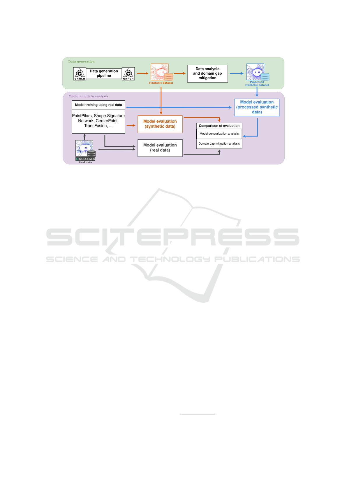
Figure 1: Methodology of the research. First, we generate a synthetic dataset, analyze it, and propose a domain gap mitigation
strategy. Then, we train different architectures of LiDAR-based 3D object detection models and evaluate their performance
with real data, synthetic data, and processed synthetic data.
3 METHODOLOGY
The methodology proposed in this research is divided
into two parts, as can be seen in Figure 1. The first
part is focused on data generation and processing, and
the second one is about model training and evaluation.
In the first part, we first generate a synthetic dataset
using the CARLA simulator, thenceforth we study the
peculiarities of these data and propose a strategy to
mitigate the potential domain gap. In the second part,
we first train state-of-the-art LiDAR-based 3D object
detection models with different architectures. Subse-
quently, we evaluate these models with a real-world
dataset (the nuScenes dataset in this case), the syn-
thetic dataset, and the processed synthetic dataset. Fi-
nally, the results of the evaluations for the different
domains are compared and analyzed.
3.1 Data Generation Pipeline
In this work, we design a pipeline for the creation of
synthetic datasets using the CARLA simulator (Doso-
vitskiy et al., 2017). This dataset will later be used to
evaluate object detection models in point clouds. We
use CARLA due to its extensive usage in state-of-the-
art research (Kloukiniotis et al., 2022; Sekkat et al.,
2022; Xu et al., 2022) and its versatile capabilities,
but other alternatives could be used as well.
3.1.1 Data Acquisition
To generate point clouds using the CARLA simula-
tor we use two virtual sensors attached to a vehicle of
the simulator. First, we use a LiDAR sensor to gener-
ate point clouds. Second, we use a semantic LiDAR,
which does not represent a real sensor but provides the
type of object the simulated LiDAR rays collide with.
Both LiDARs are needed to generate the data and the
corresponding automatic annotations. The data gen-
eration process is conducted as follows.
First, before data generation, we define the sensor
information of our setup in the standardized OpenLA-
BEL
1
format. This format defines how information
on the extrinsic and intrinsic parameters of the sensors
of the vehicle must be indicated. The flexibility of this
format allows easily defining different sensor setups
to be simulated. Once we have the sensor informa-
tion defined in an OpenLabel format file, the CARLA
map where the scene will take place is selected and
loaded. Then, we load the ego-vehicle and attach the
sensors specified in the file. After loading the map,
the sensors, and the vehicle, several actors are gen-
erated at different points of the scene, these actors
are selected from a distribution of cars, trucks, vans,
buses, bikes, motorcycles, and pedestrians. After the
loading of different actors, all of them are activated in
auto-pilot mode, enabling independent movement in
compliance with traffic regulations.
Before starting to generate and annotate data we
define a margin of 200 frames (20 seconds) for each
vehicle to reach the appropriate speed for the position
they are in, as when they are loaded, they are station-
ary. Within frame, a point cloud is stored. Then, we
use the semantic LiDAR to automatically generate an-
1
https://www.asam.net/standards/detail/openlabel/
VISAPP 2024 - 19th International Conference on Computer Vision Theory and Applications
280

notations for the actors appearing in the point cloud.
Generated data can be seen in Figure 2.
3.1.2 Data Structure
The generated dataset can be categorized into two pri-
mary components: point clouds and their correspond-
ing annotations, with the annotations being stored in
OpenLABEL format. Each scene is defined by an
OpenLABEL file, containing the timestamp of every
frame. Each frame encapsulates the following data:
• Transformation matrix: This field holds a matrix
detailing the vehicle’s position and orientation in
relation to the ego vehicle’s initial position within
the frame.
• Objects: This section comprises annotations for
the objects depicted in the frame, each consisting
of: 3D bounding box, velocity vector, accelera-
tion vector, velocity, acceleration and class.
3.2 Data Analysis and Domain Gap
Mitigation
Once we generate the data, we compare the synthetic
point clouds with point clouds of a real-world dataset
(more specifically, the nuScenes dataset). We identify
the following differences:
1. All the lasers used by a simulated LiDAR always
obtain information. This does not happen with a
real LiDAR, because either by the surface or the
material with which the laser collides or by the
weather, many of the points are lost. However,
this does not happen in a simulated environment.
2. The points form perfect circles in synthetic point
clouds. This is a result of the simulation environ-
ment. Real LiDAR cannot obtain the same accu-
racy as sensors used in simulators, due to sensor
errors, surface irregularities, weather, or even mo-
tion distortion. This is why real point clouds do
not have perfect rings like synthetic clouds.
3. Finally, another factor that causes these domains
to be different is the intensity value of the points.
Intensity calculation of CARLA lacks realism as it
solely relies on point distance, it does not take into
account the material with which the laser collides
or the angle of incidence.
These differences can be seen in Figure 3, which
illustrates variations between a point cloud from the
nuScenes dataset and a synthetic dataset. The color of
the points varies based on the intensity of the points.
Based on the detected data disparities, we propose to
process the virtually generated clouds to mitigate the
difference between the two domains as follows.
1. To solve the problem of point loss in the real envi-
ronment, some points are randomly removed from
the cloud.
2. To solve the problem of perfect virtual point
clouds, in comparison with the inherent noise ob-
tained from the measurements of real LiDAR, we
add a random noise distribution to the points.
3. Finally, to deal with the problem of intensity val-
ues, we propose to change all intensity values to a
common value.
3.3 Model and Data Analysis
To study the differences between real and synthetic
data, and the performance of object detection models
on real and synthetic point clouds. We train differ-
ent architectures of these models, along with models
having various configurations in terms of point cloud
accumulation. In this way, a more exhaustive study of
the domain gap between real and synthetic data can
be performed. We train the models with real data and
then evaluate them with real data as well as with syn-
thetic and processed synthetic data.
4 EXPERIMENTS
In the upcoming section, we delve into the experimen-
tal phase of our study, where our first objective is to
generate a synthetic dataset. We list the parameters
used in data processing and summarize the obtained
dataset. We also present the LiDAR-based 3D mod-
els we utilized, as well as their configuration.
4.1 Synthetic Data
The generated dataset consists of 9,600 point clouds,
which correspond to 96 scenes with 100 point clouds
each, at a frame rate of 0.1 seconds. Each point cloud
is labeled with information about the objects present
in it, encompassing 6 different classes: car, pedes-
trian, bicycle, motorcycle, bus, and truck. Detailed
quantitative information can be found in Table 1.
4.1.1 Data Generation
For the generation of these data, four maps from
the CARLA simulation environment are used to give
more variety to the dataset scenes these maps have
rural and urban environments. In addition, the de-
fault weather and time settings are used, because, in
the simulator, the LiDAR sensor is not affected by
these changes. In each scene, 30 cars, 10 trucks,
Analysis of Point Cloud Domain Gap Effects for 3D Object Detection Evaluation
281
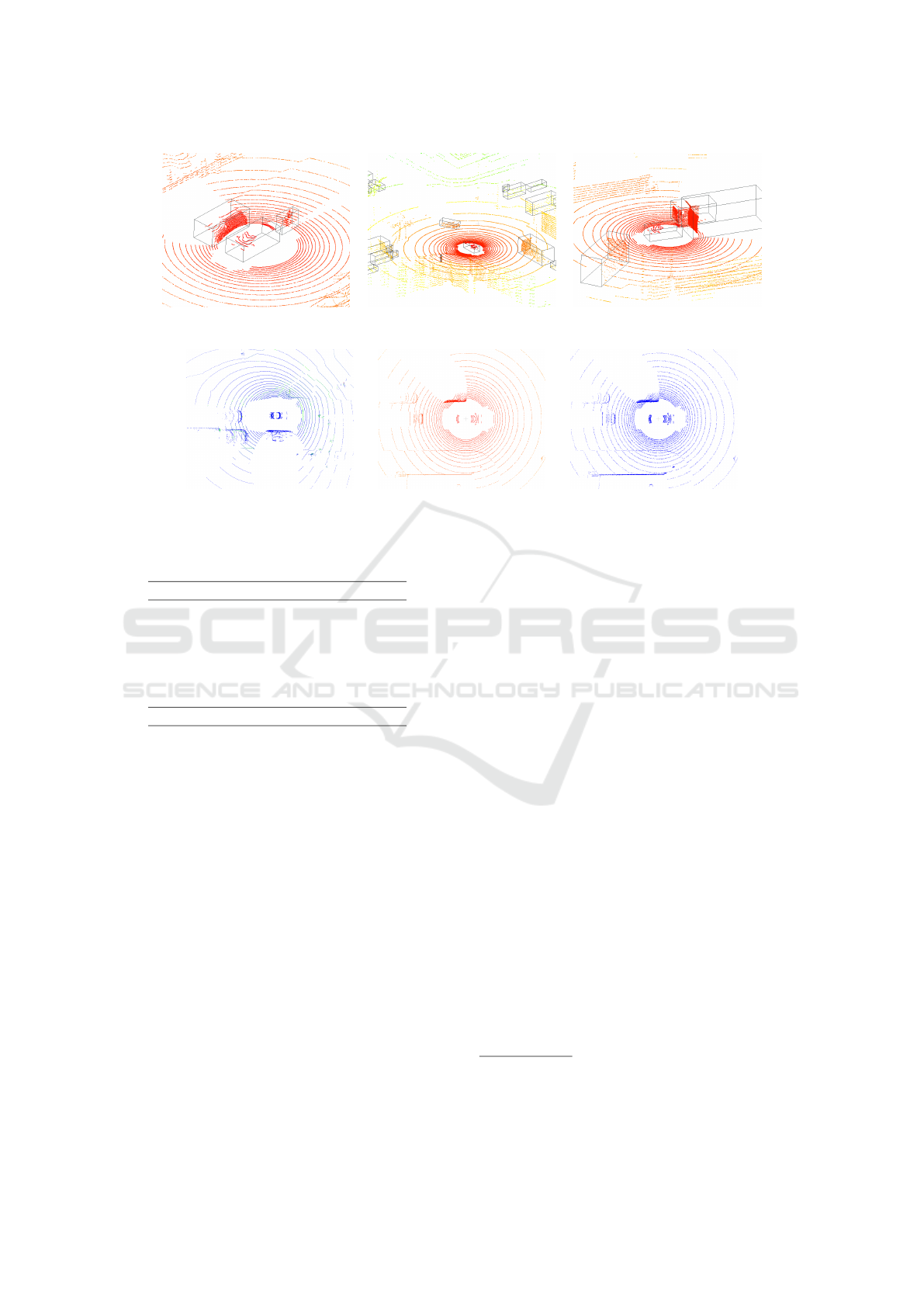
Figure 2: Example of generated point clouds. Each image is a point cloud of a different scene.
Figure 3: Comparison between point clouds of different domains. In the first column a point cloud of the nuScenes dataset, in
the second column a point cloud of the synthetic dataset and in the third column the point cloud of the synthetic dataset after
applying our processing on it.
Table 1: Number of annotations of the synthetic dataset.
Object Class Number of annotations
car 48,878
truck 26,273
bus 13,097
pedestrian 29,373
motorcycle 20,526
bicycle 18,177
total 156,324
10 vans, 10 buses, 20 bikes, 20 motorcycles and 60
pedestrians are loaded. We employ this distribution in
an attempt to simulate the distribution of the dataset
against which the models are evaluated, the nuScenes
dataset (Caesar et al., 2019).
4.1.2 Synthetic Data Processing
The values for the reduction and translation of the
points (Section 3.2) are selected trying to obtain
clouds as close to reality as possible. We empirically
found the optimal percentage of points to remove is
10% and the optimal value for the translation is a
range of [−0.05, 0.05] meters in each axis. As for the
intensity value, we decide to take the value 1 as it is
one of the most common in real point clouds since the
car is surrounded by poorly reflecting objects such as
the road. Note that these changes do not completely
eliminate the domain gap, but they do reduce it. In
Figure 3 it can be seen a comparison of the change of
the cloud before and after applying the processing.
4.2 Model Configuration and Training
For our experiments, we employ the MMDetection3D
library (Contributors, 2020) due to its rich assortment
of point cloud object detection models. We use the
nuScenes (Caesar et al., 2019) dataset. In this re-
search, we employ two categories of models of the
state-of-the-art with different architectures and prop-
erties. The first category includes PointPillars (Lang
et al., 2018) and Shape Signature Network (Zhu et al.,
2020), which convert the point cloud into an interme-
diate representation like voxels or pillars. The second
category comprises CenterPoint (Yin et al., 2020) and
TransFusion (Bai et al., 2022) (LiDAR only), which
not only transform the point cloud into an intermedi-
ate representation but also incorporate the top-view of
the point cloud. To assess the impact of point cloud
accumulation, we conduct model training in two dis-
tinct configurations: one where no sweeps
2
are incor-
porated (denoted as ”0 sweeps”), and another where
10 sweeps are integrated into the training process.
Furthermore, due to the limitations of the CARLA
simulator, only 6 classes are considered for this study
(car, truck, bus, pedestrian, motorcycle, bicycle) even
though nuScenes contains 10 classes. The models are
trained replicating the state-of-the-art configuration,
we use the usual state-of-the-art 3D object detection
2
Sweeps in the nuScenes benchmark refer to the inter-
mediate frames without annotations, while samples refer to
those key frames with annotations. Sweeps are used to ac-
cumulate point clouds and thus make the main cloud denser.
VISAPP 2024 - 19th International Conference on Computer Vision Theory and Applications
282
Table 2: Comparison of model evaluation (average precision) across 0 sweep models using three types of data: real data,
synthetic data, and processed synthetic data.
Model PointPillars (Lang et al., 2018) SSN (Zhu et al., 2020) CenterPoint (Yin et al., 2020) TransFusion (Bai et al., 2022)
Dataset Real Synth P. synth Real Synth P. synth Real Synth P. synth Real Synth P. synth
car 0.733 0.593 0.605 0.722 0.656 0.669 0.741 0.125 0.588 0.806 0.500 0.771
truck 0.306 0.584 0.582 0.372 0.633 0.630 0.399 0.007 0.428 0.426 0.500 0.831
bus 0.395 0.280 0.258 0.435 0.304 0.293 0.570 0.000 0.216 0.696 0.000 0.271
pedestrian 0.569 0.537 0.620 0.481 0.592 0.578 0.654 0.053 0.312 0.783 0.000 0.983
motorcycle 0.232 0.717 0.708 0.239 0.676 0.677 0.317 0.000 0.024 0.531 0.000 0.057
bicycle 0.034 0.432 0.428 0.027 0.528 0.502 0.180 0.053 0.119 0.285 0.079 0.351
Mean 0.378 0.524 0.533 0.379 0.565 0.558 0.477 0.040 0.281 0.588 0.180 0.544
Table 3: Comparison of model evaluation (average precision) across 10 sweep models using three types of data: real data,
synthetic data, and processed synthetic data.
Model PointPillars (Lang et al., 2018) SSN (Zhu et al., 2020) CenterPoint (Yin et al., 2020) TransFusion (Bai et al., 2022)
Dataset Real Synth P. synth Real Synth P. synth Real Synth P. synth Real Synth P. synth
car 0.803 0.662 0.673 0.816 0.615 0.636 0.821 0.331 0.563 0.871 0.000 0.770
truck 0.362 0.522 0.515 0.464 0.564 0.584 0.484 0.320 0.590 0.387 0.000 0.693
bus 0.426 0.194 0.180 0.561 0.316 0.309 0.627 0.037 0.247 0.734 0.000 0.246
pedestrian 0.742 0.873 0.841 0.665 0.769 0.732 0.748 0.455 0.949 0.866 0.000 0.974
motorcycle 0.332 0.540 0.533 0.427 0.640 0.626 0.433 0.000 0.054 0.620 0.000 0.000
bicycle 0.094 0.333 0.337 0.158 0.721 0.740 0.302 0.094 0.204 0.294 0.081 0.311
Mean 0.460 0.521 0.513 0.515 0.604 0.604 0.569 0.206 0.434 0.629 0.013 0.499
Figure 4: Average precision values for each data type: syn-
thetic (red), real (blue) and synthetic processed (orange),
without point cloud accumulation for each model.
evaluation metrics. We focus mainly on the Average
Precision (AP). Model evaluation results can be found
in Tables 2 and 3.
4.3 Analysis of the Results
The trained models are evaluated with real, synthetic,
and processed synthetic data. Results can be seen
in Tables 2 (0 sweeps) and 3 (10 sweeps). Notably,
PointPillars and SSN exhibit superior performance
on synthetic data, while CenterPoint and TransFusion
have a better performance on real data. We think that
the reason for the accuracy drop in CenterPoint and
TransFusion may be due to the use of the heatmap
obtained from the top view of the point cloud, a rep-
resentation seemingly more prone to domain gap ef-
fects. Although the difference in accuracy is low for
the first two models, the fact that it is so high for the
other two models implies that some models cannot
generalize properly and that there is indeed a signifi-
cant domain gap between synthetic and real data.
After applying our proposed processing to syn-
thetic point clouds, a comparison of model perfor-
mance reveals that those achieving superior preci-
sion on synthetic data exhibit slightly lower precision
across most classes, aligning them more closely with
results obtained from real data. The precision of Cen-
terPoint and TransFusion has increased drastically, re-
ducing the precision gap between both kinds of data.
This can be seen especially in Figure 4, where the
mean AP of each model with different data types can
be found. The loss of accuracy does not imply that
our processing does not reduce the domain gap, on
the contrary, the accuracy gap is reduced in most of
the cases. The difference between the AP in the real
and synthetic domain decreases since the processing
applied to the clouds is effective, making synthetic
and real clouds more similar.
While all models get a notable improvement when
accumulating point clouds on real data, this is not al-
ways the case with synthetic data, the only model that
behaves the same way is CenterPoint. PointPillars
and SSN hardly notice the change between single-
scan and accumulated point clouds. The accuracy
of TransFusion is reduced when accumulating point
clouds, increasing the domain gap. We conclude that
in the case of synthetic point clouds, the accumula-
tion can have different results depending on the model
used, as it can be either detrimental or favorable.
The TransFusion model exemplifies a notable de-
crease in accuracy differences across domains. With-
out point cloud accumulation, our processing reduces
the difference by 36.4% and with accumulation it is
Analysis of Point Cloud Domain Gap Effects for 3D Object Detection Evaluation
283
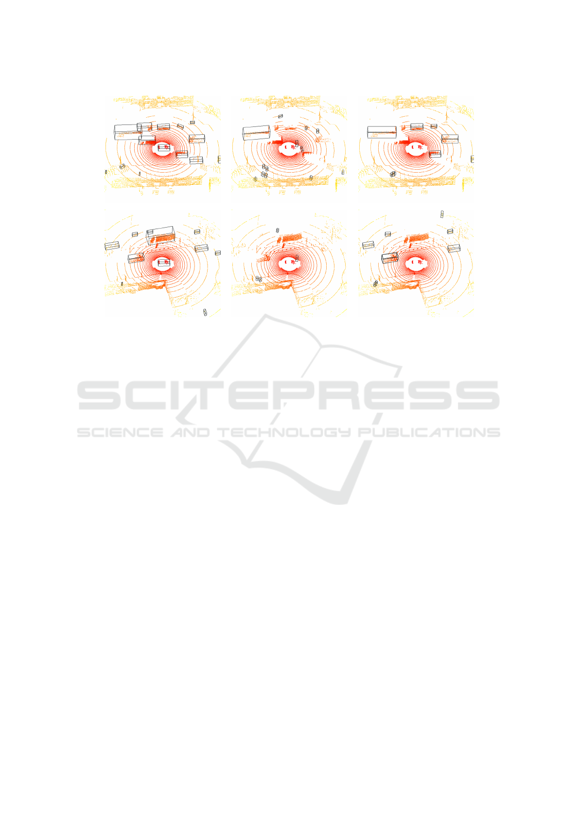
Figure 5: Comparison of detections in synthetic point clouds obtained with the CenterPoint model without point cloud accu-
mulation. In each row, there is a frame of a different scene, the left column (a) contains the ground truth bounding boxes, the
middle column (b) the detections without cloud processing and the right column (c) the detections with our cloud processing.
reduced by 48.6%. CenterPoint also reduces the accu-
racy difference with and without point cloud accumu-
lation by 24.1% and 22.8%, respectively. With Point-
Pillars, we have only achieved a reduction of 0.8%
with point cloud accumulation and with SSN we have
only archived a reduction of 0.7%. Our method effec-
tively minimizes differences across all models, par-
ticularly in the car and pedestrian classes. The impact
extends to other classes in most models. Based on
these results, we conclude that our method reduces the
difference between real and synthetic point clouds,
even though high-performing models may not be as
noticeably affected by our processing proposal.
In this paper, we also present qualitative results
in Figure 5, illustrating the detection performance
of our models on synthetic data and processed syn-
thetic data in comparison to ground truth annotations.
These images show the effectiveness of our proposed
point cloud processing techniques. By comparing the
model’s detections on raw synthetic data to those on
processed synthetic data, it is remarkable how our
point cloud processing method significantly enhances
the detection results, as a consequence of the domain
gap reduction. These images highlight the improve-
ments achieved by our approach, demonstrating the
enhanced accuracy and robustness of the detection
system when applied to processed point cloud data.
5 CONCLUSIONS AND FUTURE
WORK
Recent advancements in driving simulators have
transformed them into powerful tools for data genera-
tion. However, despite the easy access to data through
these tools, there remains a question about their suit-
ability for validating Automated Driving (AD) func-
tions. Our study shows that there is a domain gap
between real and simulated point cloud data.
Our study introduces an innovative synthetic data
generation pipeline that creates standardized data
adaptable to diverse sensor setups.
We study the evaluation of different LiDAR-based
3D object detection architectures concerning their
performance with both real and synthetic data. Our
findings reveal distinct responses across the models.
PointPillars and SSN exhibited robustness to domain
gap effects, while CenterPoint and TransFusion ex-
hibited higher challenges in object detection when ex-
posed to synthetic data. These observations empha-
size the algorithmic influence on domain gap effects,
underscoring the need for a prior analysis to assess
how synthetic data may affect a specific algorithm.
Furthermore, we examined the domain gap be-
tween real and synthetic point clouds, identifying key
distinctions. Our analysis revealed variations in re-
flected point numbers, structural differences in ring
patterns, and fluctuations in point intensity values.
VISAPP 2024 - 19th International Conference on Computer Vision Theory and Applications
284

In response to these insights, we propose a do-
main gap reduction process for point clouds. This
process proves its effectiveness through clear quali-
tative enhancements and a substantial reduction in ac-
curacy gaps among various models when comparing
their performance on real and synthetic data. Notably,
this reduction is particularly prominent in the case of
point cloud accumulation, where the CenterPoint and
TransFusion models exhibit accuracy differences that
are reduced by 22.8% and 48.6%, respectively. This
approach can be applied to more reliably validate AD
functions using synthetic point clouds.
This paper, has not investigated the potential of
training models using solely synthetic data or in con-
junction with real data, and it does not assess the con-
tribution of these data in training, with or without pro-
cessing. The exploration of this task is deferred to fu-
ture work. Regarding the domain gap, although it has
been possible to reduce it, it still exists and has not yet
been completely reduced; continuing with the quan-
tification and reduction of the domain gap in point
clouds is still a pending and developing task.
ACKNOWLEDGEMENTS
This work has received funding from Basque Gov-
ernment under project AutoTrust of the program
ELKARTEK-2023. This work is partially supported
by the Ministerio de Ciencia, Innovaci
´
on y Universi-
dades, AEI, MCIN/AEI/10.13039/501100011033.
REFERENCES
Bai, X., Hu, Z., Zhu, X., Huang, Q., and et al. (2022). Trans-
fusion: Robust lidar-camera fusion for 3d object de-
tection with transformers.
Caesar, H., Bankiti, V., Lang, A. H., and et al. (2019).
nuscenes: A multimodal dataset for autonomous driv-
ing.
Contributors, M. (2020). MMDetection3D: OpenMM-
Lab next-generation platform for general 3D ob-
ject detection. https://github.com/open-mmlab/
mmdetection3d.
Dosovitskiy, A., Ros, G., Codevilla, F., Lopez, A., and
Koltun, V. (2017). Carla: An open urban driving sim-
ulator.
Dworak, D., Ciepiela, F., Derbisz, J., Izzat, I., and et al.
(2019). Performance of lidar object detection deep
learning architectures based on artificially generated
point cloud data from carla simulator. In 2019 24th
International Conference on MMAR, pages 600–605.
Huch, S., Scalerandi, L., Rivera, E., and Lienkamp, M.
(2023). Quantifying the lidar sim-to-real domain shift:
A detailed investigation using object detectors and an-
alyzing point clouds at target-level. IEEE Transac-
tions on Intelligent Vehicles, 8(4):2970–2982.
Inan, B. A., Rondao, D., and Aouf, N. (2023). Enhancing
lidar point cloud segmentation with synthetic data. In
2023 31st MED, pages 370–375.
Kalra, N. and Paddock, S. M. (2016). Driving to Safety:
How Many Miles of Driving Would It Take to Demon-
strate Autonomous Vehicle Reliability? RAND Cor-
poration, Santa Monica, CA.
Kloukiniotis, A., Papandreou, A., Anagnostopoulos, C.,
and et al. (2022). Carlascenes: A synthetic dataset
for odometry in autonomous driving. In CVPR Work-
shops, pages 4520–4528.
Lang, A. H., Vora, S., Caesar, H., and et al. (2018). Point-
pillars: Fast encoders for object detection from point
clouds.
Li, Y. and Ibanez-Guzman, J. (2020). Lidar for autonomous
driving: The principles, challenges, and trends for au-
tomotive lidar and perception systems. IEEE Signal
Processing Magazine, 37(4):50–61.
Li, Y., Ma, L., Zhong, Z., and et al. (2021a). Deep learn-
ing for lidar point clouds in autonomous driving: A
review. IEEE Transactions on Neural Networks and
Learning Systems, 32(8):3412–3432.
Li, Y., Ma, L., Zhong, Z., Liu, F., Chapman, M. A., and
et al. (2021b). Deep learning for lidar point clouds
in autonomous driving: A review. IEEE TNNLS,
32(8):3412–3432.
Liao, Y., Xie, J., and Geiger, A. (2021). Kitti-360: A novel
dataset and benchmarks for urban scene understand-
ing in 2d and 3d.
Mart
´
ınez-D
´
ıaz, M. and Soriguera, F. (2018). Autonomous
vehicles: theoretical and practical challenges. Trans-
portation Research Procedia, 33:275–282. CIT2018.
Qiao, D. and Zulkernine, F. (2023). Adaptive feature fusion
for cooperative perception using lidar point clouds. In
Proceedings of the IEEE/CVF WACV, pages 1186–
1195.
Rong, G., Shin, B. H., Tabatabaee, H., Lu, Q., Lemke,
S., and et al. (2020). LGSVL simulator: A high
fidelity simulator for autonomous driving. CoRR,
abs/2005.03778.
Sekkat, A. R., Dupuis, Y., Kumar, V. R., and et al.
(2022). SynWoodScape: Synthetic surround-view
fisheye camera dataset for autonomous driving. IEEE
Robotics and Automation Letters, 7(3):8502–8509.
Sun, P., Kretzschmar, H., and Dotiwalla, Xerxes, e. a.
(2019). Scalability in perception for autonomous driv-
ing: Waymo open dataset.
Wang, F., Zhuang, Y., Gu, H., and Hu, H. (2019). Automatic
generation of synthetic lidar point clouds for 3-d data
analysis. IEEE TIM, 68(7):2671–2673.
Xu, R., Xiang, H., Xia, X., Han, X., and et al. (2022).
Opv2v: An open benchmark dataset and fusion
pipeline for perception with vehicle-to-vehicle com-
munication.
Yin, T., Zhou, X., and Kr
¨
ahenb
¨
uhl, P. (2020). Center-based
3d object detection and tracking. CVPR.
Zhu, X., Ma, Y., Wang, T., Xu, Y., and et al. (2020). Ssn:
Shape signature networks for multi-class object detec-
tion from point clouds.
Analysis of Point Cloud Domain Gap Effects for 3D Object Detection Evaluation
285
