
Investigating the Use of the Thunkable End-User Framework
to Develop Haptic-Based Assistive Aids in the Orientation
of Blind People
Alina Vozna
a
, Giulio Galesi
b
and Barbara Leporini
c
ISTI-CNR, Pisa, Italy
Keywords: Accessibility, Inclusive Tools, Accessible Tools, Inclusive Cultural Experience, Thunkable.
Abstract: Nowadays mobile devices are essential tools for visiting cultural heritage sites. Thus, it is very important to
provide an inclusive cultural mobile experience for anyone. In this study, we investigate how to create
accessible apps to enhance the experience of the visually impaired people in outdoor cultural itineraries. In
such a context, the integration of specific features for improving accessibility for blind people may require
high skills. This study investigates how it is possible to exploit a simple-to-use developing environment,
Thunkable framework, which does not require specific technical competencies, to easily develop an accessible
app.
1 INTRODUCTION
The World Health Organization states that more than
2.2 billion people have visual impairments, of which
1 billion have preventable or untreated problems
(WHO, 2022). This makes tasks that require spatial
understanding challenging for them. Technical
solutions to perform everyday activities that were not
previously possible (Jones et al., 2019; Wang and Yu,
2017), such as touchscreen interactions and many
applications for orientation and mobility in both
indoor and outdoor environments, but few help with
cultural routes. Our study focuses on improving
cultural guides for visually impaired visitors. We're
developing tools, including an app, that provide tour
information and accessibility details. This should
improve the experience for visually impaired users
and make them part of the tool's target audience. A
major barrier to the diffusion of accessibility is the
high skill level of the people who develop these
accessible digital solutions. Through a case study, we
propose how to create inclusive tools that are also
easy to develop. Some design aspects related to the
inclusion of accessible maps and haptic feedback are
a
https://orcid.org/0009-0009-0179-6948
b
https://orcid.org/0000-0001-6185-0795
c
https://orcid.org/0000-0003-2469-9648
1
https://thunkable.com/#/
also considered in this study. Blind and visually
impaired people use screen readers with integrated
speech synthesis to navigate websites or mobile
applications. However, for the screen reader to work
properly, it must be programmed to read and
recognize all the information on the screen as
faithfully as possible, without causing confusion or
creating an additional cognitive load. A focus group
was conducted to gain insights from the blind and
visually impaired community about digital tools to
assist in visiting cultural routes. Participant feedback
informed the development of an application to test the
potential of the Thunkable
1
framework for creating
accessible interfaces. Specifically, this paper
investigates:
1) the Thunkable framework as an end-user
development tool for the development of an
accessible app,
2) the implementation of haptic feedback as an
assistive tool in the exploration of a digital map.
294
Vozna, A., Galesi, G. and Leporini, B.
Investigating the Use of the Thunkable End-User Framework to Develop Haptic-Based Assistive Aids in the Orientation of Blind People.
DOI: 10.5220/0012181900003584
In Proceedings of the 19th International Conference on Web Information Systems and Technologies (WEBIST 2023), pages 294-301
ISBN: 978-989-758-672-9; ISSN: 2184-3252
Copyright © 2023 by SCITEPRESS – Science and Technology Publications, Lda. Under CC license (CC BY-NC-ND 4.0)

2 RELATED WORK
Smartphones and tablets are widely used by people of
all ages, including people with disabilities. They
serve as important tools, especially for the visually
impaired, acting as assistive technologies. These
technologies improve the autonomy, safety, and
social engagement of visually impaired people,
reducing their isolation. Despite the accessibility
features built into cell phones, there are apps tailored
to assist blind users with various tasks, especially
when they are outside their homes, such as navigating
cities or shopping. These apps enable full use of the
device through features such as voice commands and
auditory feedback.
Bigham et al. (2010) developed VizWiz::LocateI,
a cell phone app addressing the challenge of handling
excessive information in apps, often visually encoded
through text and colors. This complexity poses
usability issues for visually impaired users.
Innovative solutions include Blindhelper (Meliones,
2016), aiding navigation for the blind. It integrates a
smartphone app with an embedded system for
accurate pedestrian detection via GPS, obstacle
identification, and traffic light status. The app offers
voice-guided navigation and user assistance.
Another notable application, BlindNavi, attempts
to simplify navigation by combining all relevant
information into a single application. This eliminates
the need to switch between multiple apps when
navigating in nature. It uses technologies such as
iBeacon to provide accurate navigation directions to
visually impaired users. BlindRouteVision offers a
novel approach by using a smartphone app to improve
pedestrian navigation for visually impaired people
without requiring assistance. This application detects
the status of traffic lights and identifies obstacles in
the user's path to ensure safer navigation. Augmented
reality has also made strides in helping the visually
impaired. A mobile application uses augmented
reality to suggest optimal routes while taking safety
into account. It evaluates predefined parameters to
discard routes that pose a potential risk to the mobility
of the visually impaired (Medina-Sanchez, 2021). In
the area of public transportation, an app has been
developed to address a common challenge faced by
visually impaired individuals: understanding when to
signal a stop on public transit. This app informs users
of their location along the route, granting them more
independence (Lima, 2018). In contrast, another
application employs a camera and voice messages to
provide real-time identification of objects, as well as
their distance and direction relative to the camera.
(Meenakshi, 2022).
Several factors must be considered when
designing a website or application, such as the use of
alternative text, appropriate color contrasts, and the
use of markup instead of images to convey
information. All of these factors are organized by the
W3C in the form of guidelines (W3C, 2023). The goal
of this work is to design useful tools for accessible
use of itineraries, cultural (and other) routes.
3 METHOD
In this work, we assessed the accessibility support of
the Thunkable app development framework, which
offers a 'Design' section for UI layout and a 'Blocks'
section to link components. The Thunkable Live
application must be installed on the mobile device to
test the prototype on the smartphone. The main
purpose of this work is to find out whether the
framework enables the developers to create
accessible interfaces. Thus, features such as
alternative descriptions, labels of buttons and links, as
well as the inclusion of haptic features have been
considered in the design. Design specifications have
been gathered by involving potential end-users who
expressed their expectations and preferences about
tools that should be available along the itinerary.
A prototype app has been therefore designed and
developed with the Thunkable framework. In order to
make the itinerary as inclusive as possible, the use of
the QR code was exploited to make the traditional
panels that are usually available along the itinerary
usable for the blind. This is intended to enrich the user
experience and thus be a practical indication for
planners.
4 THE APP PROTOTYPE
4.1 User Requirements
To gather information from visually impaired and
blind users about their preferences and expectations
regarding the application, a series of remote focus
groups were organised. Ten users participated in the
focus groups, six blind and four visually impaired.
The focus groups addressed three different topics:
outdoor mobility (in the context of walking with a
mobile navigator/orienteer), orientation (and the
ability to explore a digital map and how it is perceived
by the user), and the user experience (and how
different technologies are used in everyday
environments, from computers to cell phones).
Investigating the Use of the Thunkable End-User Framework to Develop Haptic-Based Assistive Aids in the Orientation of Blind People
295
Some specifications for interacting with the
application were discussed with users. These include
a simple and direct navigation menu, a help button to
always assist the user in navigating, various search
options (verbal, keyboard input, and a dropdown
menu). In order to be accessible, it is important that
a) the correct labelling allows the screen reader to
read all the icons, buttons and text, and b) all the
elements of the user interface have semantics so that
the user knows the function of each element and
especially how to interact with them.
The preferences and expectations of blind users
can be summarized as follows.
In terms of mobility, users mostly prefer
vibration-based instructions, although this could be
challenging for those unfamiliar with haptic
technology. Instructions on how to use and adjust the
vibrations could help. Preferences vary: some prefer
continuous vibrations, while others opt for subtle
audible cues. Warning signals for distances, stops,
benches, crosswalks, and traffic lights are critical.
Trail verification is essential for wayfinding, which
includes a star-based (from 1 to 5) rating system and
customizable text inputs. Marking points of interest
with distinct vibrations or voice notifications, as well
as retrievable vibrations when a POI is reached, are
beneficial. Testing Thunkable's custom haptic
capabilities during map development showed great
interest. Since the application is not intended to be
used only by blind people, it was decided to complete
a questionnaire (via Google Form) to understand if
and how certain functions and features are useful for
sighted people. Questions addressed user
characterization (gender, age, how often they hike),
information that might be useful for viewing the trail,
and points of interest. A question about the type of
feedback preferred for detecting POI, and finally,
interest in wearing a device that provides more
information. Results showed overlap in desired
features between the two groups. For example, many
(50%) sighted users expressed interest in timely
information and in having content read aloud rather
than reading from the screen.
4.2 App Architecture
The app was designed to facilitate user interaction
and navigation through content with a simple and
clear layout. Our goal was to develop an accessible
mobile application that would allow visually
impaired users to interact via voice commands and
multi-touch. We designed the user interface with
2
https://www.airtable.com/
high-contrast background and foreground colors so
that visually impaired users could better identify
components on the screen. We developed the
application so that it could be used in conjunction
with the screen reader by adding a brief description of
the components that users could interact with.
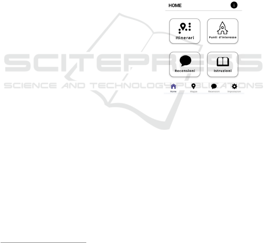
Homepage. On the home page, users will
immediately find the most important elements,
organised into four macro sections: Itineraries, Point
of Interest, Reviews and Instructions. A navigation
menu at the bottom of the app is very useful to
navigate within the different pages without getting
lost, with the possibility to return to the home page by
simply clicking on the left button. The menu is
divided into four main pages: Home, Map, Reviews
and Settings (see figure 1).
Figure 1: Screenshot of the home page.
Itineraries. In this section, the user can select an item
from a list of itineraries, with the possibility of
performing a voice search, entering the name in the
search box, or selecting by location: Toscana,
Liguria, Sardegna, Corsica, PACA (Provenza-Alpi-
Costa Azzurra). To implement the list, the 'Data
viewer list' component was added, which allows to
link a data source and select which data to display. In
the case of this project, it was decided to place all the
data in Airtable
2
, a spreadsheet that can be used to
create data tables in various formats. The information
to be displayed included the title of the trail, a subtitle
representing the region in which it is located, and an
image of the trail map. Each itinerary opens a
description page with information on name, length,
altitude, routes and navigation (for download).
WEBIST 2023 - 19th International Conference on Web Information Systems and Technologies
296
Point of Interest. In this section, the user can choose
from a list of places of interest with appropriate
search options, including selection by category:
Church, Hermitage, Parish. The data viewer list was
also used in this case, in order to be able to visualise
the data via Airtable, but compared to the itineraries,
it was decided to add a text alongside the title and
subtitle. This text represents the different POI
categories. The description page displays information
about the name, pictures, five icons for accessibility
and five icons for the vehicles you can use to reach
the place, as illustrated in figure 6.
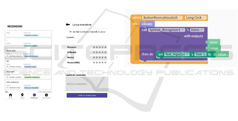
Reviews. In the “Reviews" section (see figure 2), the
user can see all the comments left by other users. In
the preview, the name of the route and the type of
disability of the commentator are highlighted.
Clicking on one of the comments opens the page with
the comment and the rating (stars received) for the
different categories: Route, Difficulty, Services,
Accessibility.
Figure 2: Screenshot of the Review page.
Instructions. Finally, the 'Instructions' button is
designed to help users navigate each page. In addition
to this button on the home page, a small button has
been added in the upper right corner to provide the
ability to access the instructions at any time. The
tutorials are organised so that the page titles are
displayed and clicking on one of these titles displays
the explanatory text. The buttons have been designed
in line with the app's colour palette, i.e. white text on
a purple background.
4.3 Accessibility Features
Blind and visually impaired people use a screen
reader with integrated speech synthesis to navigate
web portals or mobile devices. However, for the
screen reader to work properly, it must be
programmed so that all information on the screen is
read and recognized as faithfully as possible. By
following the W3C Web Accessibility Guidelines
(WCAG) 2.2 we were able to make the application
suitable for use by visually impaired users and others.
According to users' preferences and expectations, the
following accessibility features were implemented in
the prototype app. This allowed us to test whether the
Thunkable development environment enables the
inclusion of such features.
Microphone. Using the microphone for searching is
a useful navigation option for all user categories. To
enable this tool, the voice recognition component has
been integrated. This is an invisible component that
listens to the target voice and returns a text value after
the entire sentence is spoken. It stops listening when
all sounds have been revealed.
Figure 3: Microphone usage code.
As illustrated in figure 3, for the text value it
returns, 'Text's input text' was set to the value of the
speech recognizer. So as soon as the speech is
finished, the text is transferred to the search box.
When the user taps the microphone once, a short
vibration alerts them that it is a record button. If, on
the other hand, it is held down, a longer vibration
alerts the user to the possibility of recording. Since it
is not enough to convey information only via a
vibration, this feedback was combined with a voice
output for better understanding.
Page Structure. Navigation between pages is made
difficult when information is arranged without a
logical structure. Moreover, too much information on
a single page leads to such confusion that users are
forced to abandon the page, leaving them frustrated.
Thus, it is important to arrange all elements and
information in a simple and easy-to-understand way,
create simple pages and move excess information.
Additional information can be activated via buttons if
the user has an interest in going deeper, saving time
Investigating the Use of the Thunkable End-User Framework to Develop Haptic-Based Assistive Aids in the Orientation of Blind People
297
listening to the excess information. Finally, on the
travel page, it was decided to structure the
information about altitudes and elevations in a way
that can be better read by the screen reader, avoiding
columns that are difficult to decipher by the screen
reader.
Alternative Text/Description. According to W3C
guidelines, it is necessary to insert alternative text for
images, video graphics and buttons. Since there is no
way to insert alternative text for images in Thunkable,
all images have been converted to buttons. This
makes it possible to insert text that is not visible on
the page, but can be recognized by the screen reader
and thus read by users. For accessibility reasons, each
button has text describing its function and explaining
what it depicts.
Digital Map. The biggest challenge was making the
map accessible, as Thunkable does not have the tools
to create it. To make the map more user-friendly, the
first step was to include a pop-up warning about
activating GPS. Activating the code starts the position
sensor, which detects the user's current position and
displays it on the map with a different colored marker.
Then all the markers of the points of interest of the
different locations are displayed as illustrated in
figure 4.
Figure 4: Example of code to add marker.
As illustrated in figure 5, the ‘Navigate by Region’
button allows the user to select one of the six regions
to avoid moving around the screen and losing control
of the map. By selecting the region, the map zooms in
on the selected location with its points of interest.
Clicking on POI activates a dual recognition vibration
with speech synthesis that announces the name
(Paratore, 2023).
Dark Screen Mode. Dark mode or dark theme
indicates a negative contrast polarity in which text
and background colors are inverted and it is an
excellent aid for visually impaired people as, thanks
to the dimming of the screen allows them to see and
read content and reduces eye fatigue. During the
questionnaire administered to blind and visually
impaired users, it emerged that most visually
impaired users prefer dark mode mainly because of
the sunlight reflecting off the screen does not allow
them to view the content present. Therefore, it was
decided to include this mode in the project as well.
Figure 5: Map showing the points of interest and the
“Navigate by Region” button.
Haptic. Haptic systems are critical in providing users
with a variety of feedback on their actions, often
using sound and vibration. This project focused on
optimizing haptic feedback, primarily through sound
and vibration, for assistive smartphone technologies.
The design was primarily aimed at improving the
effectiveness of interactions, especially for blind
users. To make vibration informative for blind users,
a combination of adaptive vibration and audio
feedback was considered. A specific example is the
use of double vibration patterns with a short pause to
distinguish interactions. These intuitive vibrations
were complemented by clear explanations on the
app's user interface to enhance usability. The study
also explored the integration of auditory cues with
haptic feedback, as both modalities can convey
information synergistically. This hybrid approach
was evident in voice search, where different
vibrations combined with voice instructions
improved users' understanding of available actions.
In addition, the study presents an innovative approach
by combining audio feedback with haptics. A notable
example is the "play or pause" function on the page
describing points of interest (POI). This feature
consists of two different buttons, "Play" and "Stop","
WEBIST 2023 - 19th International Conference on Web Information Systems and Technologies
298
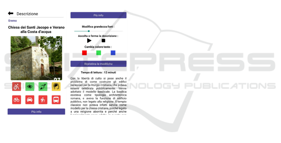
which allow the user to trigger the voice output of the
description text or to pause it if needed. The choice of
these buttons is based on the recognition that not all
users rely exclusively on screen readers. These
buttons provide a comprehensive solution for the
different user groups of the app with different
preferences. It's worth noting that this feature isn't
only beneficial for the visually impaired, but enriches
the experience for all users.
Customization. A button is located on the
description page of all POIs. It is used to change the
text size, which by default starts at 18 and goes up to
50. It is also possible to have the description read
aloud using a text-to-speech function. Finally, it is
possible to change the color of the text. A very useful
feature not only for the visually impaired, but also for
the color blind or people with other visual
impairments.
Figure 6: Screenshot of the description POI page.
5 EVALUATION
5.1 User Testing
In collaboration with the Italian Association of the
Blind (Unione Italiana Ciechi e Ipovedenti), a test
was conducted to evaluate the use of the prototype by
visually impaired people. During the tests, the
difficulties encountered by the users were observed
and analysed in order to identify the possible
problems and find solutions to improve the
application or the function.
For the tests, an Android-based smartphone was
chosen as the test device, on which the Thunkable
Live development platform was installed. In this way,
it is possible to perform a live test considering all the
developed components mentioned in the previous
section.
Tasks. To evaluate usability, a series of tasks were
outlined for users to complete. These tasks involve
goal-oriented activities, requiring descriptions of the
steps taken, task duration, and whether they were
successfully accomplished. Six tasks were proposed
to each user:
1. From the ‘map section’, navigate by choosing a
region and find the different POIs of the selected
region.
2. Within the ‘POI page’, filter the search in
"Church," by category selection, choose one and
read the description page.
3. Perform a search for POIs via the search box.
4. In the ’Itineraries page’, search for a route via
voice search, select the route and read the found
page.
5. In the description of the itineraries, add a user
review.
6. Read the reviews added by other users.
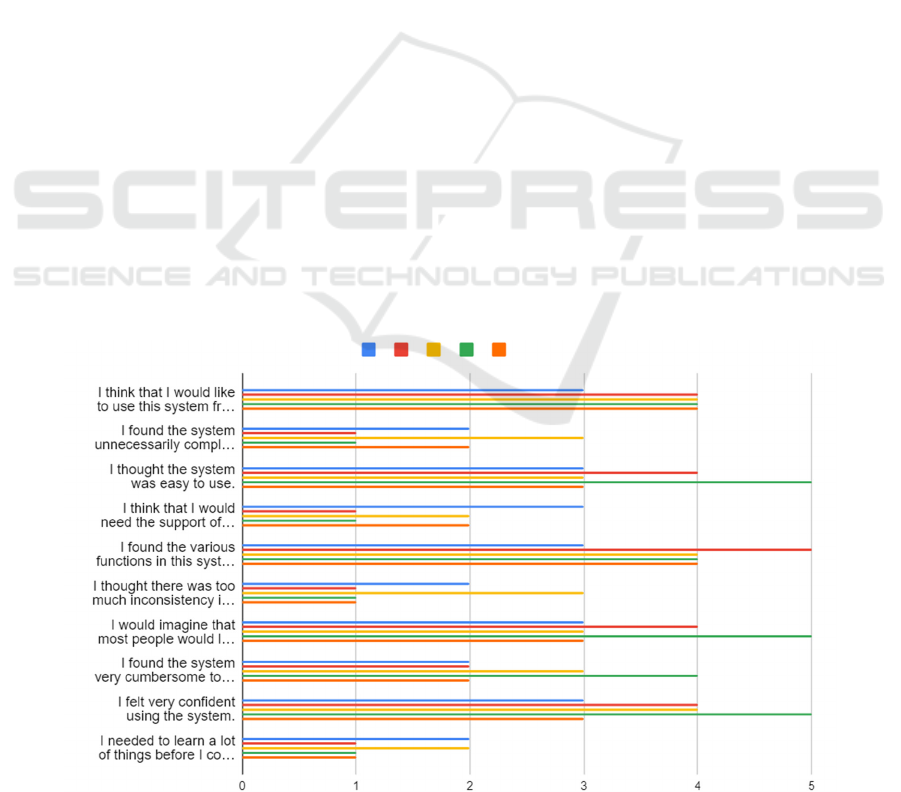
SUS – System Usability Scale (Sauro, 2011). Once
the user-test tasks have been completed, users are
presented with a short questionnaire to be completed,
the System Usability Scale. The SUS is a 10-item
questionnaire with 5 response options, where 1
indicates "strongly disagree", while 5 indicates
"strongly agree". The questionnaire is composed as
follows:
1. I think that I would like to use this system
frequently.
2. I found the system unnecessarily complex.
3. I thought the system was easy to use.
4. I think that I would need the support of a
technical person to be able to use this system.
5. I found the various functions in this system were
well integrated.
6. I thought there was too much inconsistency in
this system.
7. I would imagine that most people would learn to
use this system very quickly.
8. I found the system very cumbersome to use.
9. I felt very confident using the system.
10. I needed to learn a lot of things before I could
get going with this system.
5.2 Participants
Only 5 users gave their consent to participate in the
test": 4 blind and 1 visually impaired, aged from 45
Investigating the Use of the Thunkable End-User Framework to Develop Haptic-Based Assistive Aids in the Orientation of Blind People
299
to 60. Four users were male and one female. Two of
blind participants (one male and one female) are very
expert users while the other ones considerate
themselves as intermediate users.
5.3 Results
During the test, time was measured and interaction
with the product was analysed: all tasks were
completed smoothly in a short time, in average about
five minutes, for completing all the tasks. The
interaction did not show major difficulties in
understanding the use of the interfaces except in a few
cases that were reported in order to improve the
application.
Limitations. The development of the app
encountered several challenges that underscored the
complexity of creating an optimal user experience for
people with visual impairments. One major hurdle
was the use of the map function, particularly the
accurate selection of markers for navigation. This
underscored the need for precise design of haptic
feedback to effectively distinguish between different
inputs.
Inconsistencies in the wording of the rating page
on different devices also proved to be a drawback.
The content appeared in different languages on
different cell phones, which can create a language
barrier for users. This underscores the importance of
thorough cross-device testing to ensure consistency
regardless of user location or device settings.
Screen reader accessibility issues were another
problem. Some screen readers had difficulty
recognizing the microphone button for voice input,
which hindered voice search functionality.
Additionally, the 'Search' button lacked clear
warnings upon activation, potentially confusing users
during search operations. The absence of
comprehensive auditory and tactile cues highlighted
the necessity for more intuitive and complete
feedback mechanisms.
Concerning the SUS questionnaire, the results
collected so far show a positive average, where the
user did not find difficulties in using the system,
finding it simple and well organized. Figure 7 shows
the results of the SUS questionnaire.
6 CONCLUSIONS AND FUTURE
WORK
This work investigated the accessibility by design
offered by the Thunkable Framework. The study
found that creating an accessible app with Thunkable
is suitable for people without programming skills.
However, ensuring accessibility often requires
specific customization, as certain features are not
directly supported by the framework. In particular,
being compliant with accessibility principles such as
alternative image descriptions requires specific
solutions. This challenge, already noted in other
development environments such as App Inventor
(Leporini, 2020), underscores the importance of the
Figure 7: The results of the SUS questionnaire responses.
WEBIST 2023 - 19th International Conference on Web Information Systems and Technologies
300

contributions of this study. The key innovation lies in
the development of an app prototype using the
Thunkable framework. This app is designed to
facilitate navigation and exploration of outdoor
environments, with a focus on travel routes. The app
seamlessly provides information about itineraries and
points of interest along the routes and allows users to
post and access reviews from others. The app also
integrates a digital map for navigating different
regions. What makes the app special is the explicit
consideration of accessibility during development.
This includes the inclusion of alternative text, voice
dictation via the microphone, and the implementation
of haptic feedback, which enhances the user
experience when exploring the digital map.
The evaluation found that some adjustments are
needed to address the limitations of the Thunkable
platform. Therefore, a recommendation for future
development of this project is to improve accessibility
through targeted design. It might be useful to provide
users with an overview of the route within the routes
in the form of a video presentation or photos of key
points. Also, it would be a good option to offer the
possibility to select a language other than Italian.
During the evaluation, difficulties arose in the
map design, so some information essential for good
usability could not be included. In this case, with a
view to the future, the code could be modified to store
points of interest and users' favourite routes.
The Thunkable platform is constantly being
updated, and new features could overcome the
highlighted limitations, making it easier to exploit
multimedia and multimodal functionalities for
enhancing inclusion; as a result, we intend to conduct
a new test with a larger number of participants
shortly.
ACKNOWLEDGMENTS
This work was funded by the Italian Ministry of
Research through the research projects of national
interest (PRIN) TIGHT (Tactile InteGration for
Humans and arTificial systems).
REFERENCES
Bigham, J. P., Jayant, C., Miller, A., White, B., Yeh, T.
(2010). VizWiz:: LocateIt-enabling blind people to
locate objects in their environment. In 2010 IEEE
Computer Society Conference on Computer Vision and
Pattern Recognition-Workshops (pp. 65-72). IEEE.
Hsuan-Eng Chen, Yi-Ying Lin, Chien-Hsing Chen, and I-
Fang Wang (2015). BlindNavi: A Navigation App for
the Visually Impaired Smartphone User. In Proceedings
of the 33rd Annual ACM Conference Extended
Abstracts on Human Factors in Computing Systems
(CHI EA '15). Association for Computing Machinery,
New York, NY, USA, 19–24.
Jones, N., Bartlett, H. E., & Cooke, R. (2019). An analysis
of the impact of visual impairment on activities of daily
living and vision-related quality of life in a visually im-
paired adult population. British Journal of Visual
Impairment, 37(1), 50-63
Leporini, B., & Catanzaro, G. (2020). App Inventor as a
Developing Tool to Increase the Accessibility and
Readability of Information: A Case Study. In 9th
International Conference on Software Development
and Technologies for Enhancing Accessibility and
Fighting Info-exclusion (pp. 71-75).
Lima, A., Mendes, D., & Paiva, S. (2018). Outdoor
navigation systems to promote urban mobility to aid
visually impaired people. Journal of Information
Systems Engineering & Management, 3(2), 14.
Medina-Sanchez, E. H., Mikusova, M., & Callejas-Cuervo,
M. (2021). An interactive model based on a mobile
application and augmented reality as a tool to support
safe and efficient mobility of people with visual
limitations in sustainable urban environments.
Sustainability, 13(17), 9973.
Meenakshi, R., Ponnusamy, R., Alghamdi, S., Khalaf, O. I.,
& Alotaibi, Y. (2022). Development of a Mobile App to
Support the Mobility of Visually Impaired People.
CMC-Comput. Mater. Contin, 73, 3473-3495.
Meliones, A., Filios, C. (2016). Blindhelper: A pedestrian
navigation system for blinds and visually impaired. In:
Proceedings of the 9th ACM International Conference
on PErvasive Technologies Related to Assistive
Environments, pp. 1-4, ACM.
Paratore, M. T., & Leporini, B. (2023). Exploiting the
haptic and audio channels to im-prove orientation and
mobility apps for the visually impaired. Universal
Access in the Information Society, 1-11.
Sauro, J. (2011). Measuring Usability with the System
Usability Scale (SUS), https://measuringu.com/sus, last
accessed 2023/06/20.
Theodorou, P.; Tsiligkos, K.; Meliones, A.; Filios, C.
(2022). An Extended Usability and UX Evaluation of a
Mobile Application for the Navigation of Individuals
with Blindness and Visual Impairments Outdoors—An
Evaluation Framework Based on Training. Sensors
2022, 22, 4538.
W3C (2023). Web Content Accessibility Guidelines
(WCAG) 2.2 W3C Candidate Recommendation Draft
17 May 2023. https://www.w3.org/TR/WCAG22/
Wang, S., & Yu, J. (2017). Everyday information behaviour
of the visually impaired in China. Information
Research: An International Electronic Journal, 22(1),
n1.
WHO (2022). World Health Organization.
Report on
Blindness and vision impairment, retrieved at Blindness
and vision impairment (who.int)
Investigating the Use of the Thunkable End-User Framework to Develop Haptic-Based Assistive Aids in the Orientation of Blind People
301
