
Method for Processing High-Resolution Satellite Images, Based on
Multi-GPU Programming
Christian Ovalle
1a
, Sandra Meza
2b
, Wilver Auccahuasi
3c
, Oscar Linares
4d
, Kitty Urbano
5e
,
Gabriel Aiquipa
6f
, Yoni Nicolas-Rojas
7g
, Aly Auccahuasi
8h
, Tamara Pando-Ezcurra
9i
and Karin Rojas
10 j
1
Universidad Tecnológica del Perú, Lima, Peru
2
Universidad ESAN, Lima, Peru
3
Universidad Privada del Norte, Lima, Peru
4
Universidad Continental, Huancayo, Peru
5
Universidad Científica del Sur, Lima, Peru
6
Universidad Tecnológica de los Andes, Apurímac, Peru
7
Escuela superior la Pontificia, Ayacucho, Peru
8
Universidad de Ingeniería y Tecnología, Lima, Peru
9
Universidad Privada Peruano Alemana, Lima, Perú
10
Universidad César Vallejo, Lima, Peru
kurbano@cientifica.edu.pe, gaiquipa@utea.edu.pe, yoninicolas@elp.edu.pe, aly.auccahuasi@utec.edu.pe,
tamara.pando@upal.edu.pe, krojas@ucv.edu.pe
Keywords: Satellite Image, Processing Time, Schedule, GPU, Multi GPU.
Abstract: Satellite images are being widely used today, due to the amount of information it represents, with greater
emphasis on availability, we find many services where we can download images in their multiple formats
and combinations, that is why we can mention that the Satellite images can be classified, by their resolution,
use, amount of spectral bands, among others, but they have something in common, which is the size they
occupy on the disk, we can find images that can weigh between 500 MB when it is made up of a single band
and reduced coverage on the ground, up to 10GB images can weigh, containing more than 4 bands and with
a greater coverage of the ground. To be able to work with these images, it is necessary to have workstations
with great computational capacity, to be able to support this large volume of information, which is why in
many cases clusters of workstations are used. In this work, a very practical mechanism will be presented for
processing and working with these images, using GPU, in various configurations, such as a normal case that
has a single GPU and in cases where it is counted With two GPUs, to test the methodology we work with
different satellite images of different weights and they applied basic processes, processing times were
measured in the CPU, in one GPU and in two GPUs, which were presented as results, we can indicate that
the methodology can be scalable towards the processing of different images.
a
https://orcid.org/0000-0002-5559-5684
b
https://orcid.org/0000-0002-4650-1340
c
https://orcid.org/0000-0001-8820-4013
d
https://orcid.org/0000-0002-7952-9518
e
https://orcid.org/0000-0003-2009-000X
f
https://orcid.org/0000-0002-3755-7393
g
https://orcid.org/0000-0001-6493-6084
h
https://orcid.org/0000-0001-5069-0415
i
https://orcid.org/0000-0003-0301-3440
j
https://orcid.org/0000-0002-6867-0778
618
Ovalle, C., Meza, S., Auccahuasi, W., Linares, O., Urbano, K., Aiquipa, G., Nicolas-Rojas, Y., Auccahuasi, A., Pando-Ezcurra, T. and Rojas, K.
Method for Processing High-Resolution Satellite Images, Based on Multi-GPU Programming.
DOI: 10.5220/0011962900003612
In Proceedings of the 3rd International Symposium on Automation, Information and Computing (ISAIC 2022), pages 618-626
ISBN: 978-989-758-622-4; ISSN: 2975-9463
Copyright
c
2023 by SCITEPRESS – Science and Technology Publications, Lda. Under CC license (CC BY-NC-ND 4.0)

1 INTRODUCTION
Today there are many applications to be able to
work with satellite images, between commercial and
free use, as well as many alternatives using different
computational tools that carry out tests to optimize
the use of the hardware that is intended to be able to
work with the images having in consideration of the
processing time and the response that the hardware
has to the large size of the satellite image. Making a
review of the literature, we found investigations
where reference is made to the use of satellite
images in its different types, such as optical and
radar, using different hardware and software
configurations.
We found works where reference is made to the
analysis of land cover by analyzing chromatic
characteristics, using synthetic aperture images,
which are better known as Radar images
(Auccahuasi, 2020). In the analysis of optical images
we also find works on the analysis of land cover
based on chromatic characteristics (Auccahuasi,
2018). In the work of optical images, we find works
where reference is made to the use of GPGPU
programming where the intention is to apply these
techniques to improve performance in the process of
satellite images (Auccahuasi, 2019).
In the study of large areas of land obtaining a
level of detail, through satellite images which
provide observation of the Earth which are
composed of a series of spectral bands which will
depend on the type of satellite mission which has
been conceived of the optical instrument considered
as a payload which have been represented as
multidimensional and large arrays, which requires a
good team to carry out image processing and
requires specialized software allowing a visual
interpretation of satellite images, with which it is
possible to work with These images with different
configurations are normally used with separate band
configurations where each band is worked
separately, however these images have a
particularity such as high resolution with panoramic
bands with the maximum resolution which can vary
from metric to sub-metric where the red, green, blue
bands and short wave and infrared significant wave
found in a range with low spatial resolution
(Auccahuasi, 2020).
We find satellite images with a panoramic
approach where high resolution panoramic images
and low resolution multispectral images are merged,
which is considered an important image processing
chain, the more the resolution increases and the
number of images about the panoramic approach
increases. processing time, so multithreaded
programming and general-mode GPU programming
(GPGPU) implementation which improves
performance about applications over image
processing to perform operations by analyzing
individual pixels (Kutbay, 2020).
We find works where the use of convolutional
neural network (CNN) models is used, for which it
must be expanded with respect to graphic processing
units (GPU) due to computational characteristics, to
perform the classification and detection of objects,
in the critical environments the reliability of the
models has software errors, so our objective is to
analyze the reliability of the VGG model, through a
CNN architecture, which has 2 metrics such as the
so-called Kernel Vulnerability Factor (KVF ) used to
identify vulnerable kernels and the Layer
Vulnerability Factor (LVF) used to determine the
propagation of track failures across layers, so the
new model is run by an NVIDIA GPU with an
assessment tool like the fault injector called
SASSIFI, from which it was obtained as a result that
Im2col has vulnerability between the cores and on
the hardening of the core which realizes a reduction
of the rate of corruption of silent data by 85.67%
with a time penalty of 35.63%, with an average error
which causes a misclassification of 19.7% in the
high and unacceptable injection mode this failure
mode will affect KVF and LVF because in the RF
mode it is performed at the architecture level unlike
the IOV and IOA modes at different levels then they
have been compared between VGG, AlexNet and
ResNet which indicates that LVF and KVF are
considered within the CNN network architecture,
due to the network layers, especially the
convolutional layers, responsible for implementing
the most vulnerable and invoked Im2col kernel in
these CNN networks (Wei, 2020) .
In the use of satellite images for the analysis of
disasters to ecology, such as the analysis of the oil
spill, which have adverse effects on the environment
and the economy, for which the best resources must
be available for the response to cleaning and control
incidents for which we use a multi-temporal remote
detection Technologies (RS) for the detection of
monitoring of oil spills in the ocean in the updated
RS data have been used for the detection of
hydrocarbons which require a lot time and over with
high price so the proposal of the work is detection of
oil spills starting from the voluminous multi-
temporal images LANDSAT-7 with the use of high-
performance technologies through a graphics
processing unit (GPU) and the interface Message
Pass-Through (MPI) to speed up the detection
Method for Processing High-Resolution Satellite Images, Based on Multi-GPU Programming
619

process and provide fast response, the GPU was
based on Kepler's compute architecture (Tesla K40)
using the Unified Computing Device (CUDA)
containing parallel programming with detection
algorithms, with this detection technique have been
adapted to GPU-based processing include the band
ratio and morphological attribute profile (MAP )
based on 6 structural and shape description
characteristics, namely, gray mean, standard
deviation, elongation, shape complexity, robustness
and orientation, the experiments showed significant
gains about computational speed implemented with
in a GPU and MP, making the comparison of a GPU
versus CPU, an approach with an acceleration of
around 10 × for MAP and 14 × s for band ratio
approaches, which includes the cost of data transfer,
can be seen with the MPI implementation that uses
64 cores outperforms the GPU and executes the task
which takes a long time to compute in 18 min,
unlike the GPU, it consumes about an hour
(Bhangale, 2020).
We find works where the growth of space debris
is analyzed for which a distributed monitoring is
required in order to avoid possible space collisions,
mediated a space surveillance that is based on a
terrestrial telescope which allows to track the traffic
about Space Objects Residents (RSO) in Earth orbit,
for which various applications are used such as
prediction of orbits and the evaluation of
conjunctions, for this reason the research proposes
an optimized and performance-oriented pipeline for
the extraction of sources for the automatic detection
of spatial debris in optical data which is a method
for detection that is based on morphological
operations and the Hough transform for lines, with
near real time analysis which is obtained using
general purpose computing in graphics processing
units (GPGPU), with a high degree of processing
parallelism provided by GPGPU pe Allowing to
divide the data analysis into thousands of threads to
process large data sets with limited computational
time, this proposal was approved on a large and
heterogeneous image data set with satellite images
with various orbital ranges with multiple observation
modes , which have been taken in the observation
campaign carried out from the EQUO observatory
that was installed in the Broglio Space Center (BSC)
in Kenya, which is part of the ASI-Sapienza
Agreement (Diprima, 2020).
One of the new techniques is related to being
able to analyze about the performance demands of
on-board computing taking into account both the
performance from the control parts being a payload
requiring advanced electronic systems capable of
high computational power under the limitations of
the harsh space environment, which is why a study
about the application of integrated GPUs in space
has started, which showed better performance due to
the proliferation in consumer markets based on
competitive European technology for which it is an
analysis of the application domains in order to
identify which software domains can benefit from
their use, the domain of the integrated GPU was also
analyzed to evaluate whether or not it meets the
computing power necessary for adoption in space
(Kosmidis, 2020).
In the use of radar technologies, they are used in
remote detection by satellite in order to carry out
monitoring of geographical hazards and risk
management at a synoptic scale, there is an
advanced algorithm of multi-temporal SAR
interferometry with which it can be detected ground
deformations and structural instability with
millimeter precision for which capacity is needed in
hardware resources, for which a system is
implemented that contains the computation and GPU
programming considered as an efficient
implementation with time of image algorithms, with
the which improves the emergency management
service that is based on earth observation
technology, the preliminary evaluation of the GPU
processing potentials is made, then it was compared
with the CPU and GPU implementations of the
algorithm cores time-consuming InSARs (Guerriero,
2015).
After a detailed analysis of the different works
related to the use of the GPU in image processing,
we can indicate that our proposal helps the scientific
and academic community in the analysis of satellite
images, the proposal is to present a method to work
with various hardware configurations, such as CPU,
GPU and 2 GPUs, taking as reference a large image,
which can be processed in each of the cases, the
results will determine under what conditions it is
useful to work with each of them.
2 MATERIALS AND METHODS
The materials and methods are based on Figure 1,
which indicates the steps to follow to explain in
detail the proposed methodology, where each of the
procedures will be solved so that it can be applied in
other problematic situations.
ISAIC 2022 - International Symposium on Automation, Information and Computing
620
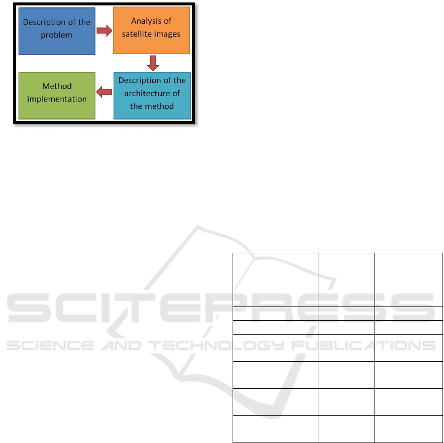
Figure 1: Proposal block diagram.
2.1 Description of the Problem
The description of the problem consists of being
able to clearly explain the problem that one has
when working with satellite images, one of the main
factors is the format, it is the first obstacle that one
has, depending on the level of processing these can
change, the common format to work and that is read
by most of the programs is the GEOTIFF. Another
problem is the area of interest, in many cases the
area of interest to be studied and analyzed is
relatively smaller than the original image, so in order
to extract the area of interest, it is necessary to load
the original image and this is already a task that the
station where you work must fulfill, another
common problem is the amount of bands present, so
most of the images have 4 bands. Making a
comparison with an image in the color settings, this
image has 3 color bands (R, G, B), so any
visualization program can display it, but if the image
has more than 4 bands, these will not can be read
and much less visualized, it is where specialized
applications are used to work with satellite images,
which performs operations to separate the images
into separate bands and thus be able to put them
together in groups of 3 images, where the images
can be viewed In the different combinations, in our
case we will take this problem where we have the 3
bands in the image, in the following procedure we
explain the analysis of these satellite images.
2.2 Analysis of Satellite Images
The satellite images have different configurations,
size, resolution, weight in MB, number of bands
among others, each of them depends on the mission
that produces it, from this group they can also be
presented in the different products that can be
presented, to For the purposes of demonstrating the
methodology, the use of the characteristic of
"number of bands" and weight in MB of the images
is used. For this reason, in Figure 2, a list of 6
images is presented grouped by size in MB, ordered
by the smallest the higher, from where we can
indicate that the image of a single band and of less
weight is the first image in the list, with a weight in
GB of 0.3, this image takes a time to be loaded in
memory of 1.47 seconds and the image The largest
image is the last image on the list with a size of 9.4
GB where the loading time of the image in memory
is 29.54 seconds. Each one of the images presented
in table 1, has its corresponding loading time in
memory. These 6 images will be the ones we will
use to check the methodology.
Let's consider that the loading time is due to the
computational capacity with which we are working,
an I7 CPU with 32 GB of memory and a solid state
hard disk.
Table 1: Group of images that will be subjected to the
methodology.
Satellite image
type
Image
size in
GB
Time to
load into
memory in
seconds
merged image 0.310 1.47
merged image 0.850 2.75
image with
separate band
1.17 3.45
image with
separate band
2.1 10.16
panchromatic
image
2.5 12.48
panchromatic
image
9.4 29.54
2.3 Description of the Architecture of
the Method
The methodology consists of the use of hardware
and software components, to be able to execute the
different algorithms developed, to evaluate the
methodology and demonstrate its applicability, as a
base programming system, the use of the MATLAB
computational tool is used, because it presents us
with an environment of adequate programming as
well as it has libraries for the access and direct work
with the GPUs of the NVIDIA brand. As a hardware
resource, a workstation composed of an i7 CPU is
used, with 32 Gb of internal memory and a solid
Method for Processing High-Resolution Satellite Images, Based on Multi-GPU Programming
621
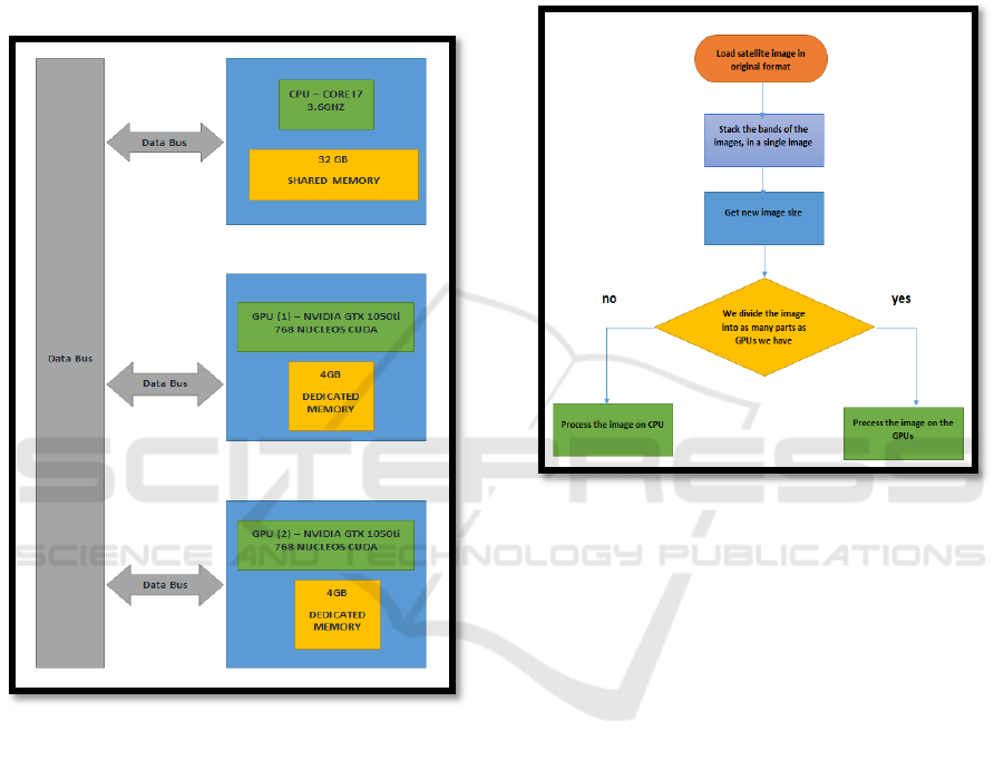
state hard disk, and as main hardware two graphics
processors (GPU) model GTX 1050ti from NVIDIA
that has 768 cuda cores. and 4GB of dedicated
memory, in figure 2, the description of the
architecture that we have to test the methodology is
presented, one of the considerations that must be
taken into account is that both GPUs have the same
characteristics, this characteristic is important for the
load balancing.
Figure 2: Configuration of the architecture available to
demonstrate the methodology.
2.4 Method Implementation
The implementation method consists of analyzing
the satellite images in such a way that its dimensions
can be obtained in order to test the methodology, the
mechanism consists of analyzing three situations, the
first is to carry out the processing in the CPU, the
second is to carry out the process in a GPU and the
third is to perform the process on two GPUs, the
processing is performed by performing the following
operations on the images, represented in the
following Pseudo code:
• We load the image
• We create a super image, joining all the
images one after another
• We make the adjustment in the contrast of
the image
• We perform the equalization of the
histogram
• We apply a Gaussian filter
• We calculate the complement of the image
Figure 3: Flow chart for the process of selecting the
architecture to choose.
In figure 3, the flow diagram for the selection
process of the architecture to choose is presented,
the choice of choosing whether to use the CPU or
the GPU consists of analyzing the size of the
images, at this time to be able to analyze and
demonstrate the methodology, procedures are
performed manually.
ISAIC 2022 - International Symposium on Automation, Information and Computing
622
Figure 4: Working model diagram using two GPUs.
In figure 4, the working model is presented when
using two GPUs, reading the original image,
obtaining its size and dimensions; For the super
image creation process, all the bands present in the
images are concatenated, in a classic way as satellite
images are presented, an image can contain 4
spectral bands that present a specific sensor, for
example an image can contain the following bands
(Red, green, blue, near infrared), depending on the
level of image processing and the mission that
performed the acquisition, these images may have
more than one band. When you have the super
image, the next process is to divide the super image
into equal parts, in our case as we have two GPUs,
the super image is divided into two images of equal
sizes.
The processing is carried out in parallel on both
images, after the result is obtained, the images are
joined again, with which we have the image in the
original format, for the processing that is considered
necessary.
Figure 5: Super image creation function.
Figure 5 presents the super image creation function,
the function receives the original image as a
parameter, where first we obtain the image
dimensions, then we decompose into separate
images for each band and finally we concatenate all
the images and the output of the function returns the
super image.
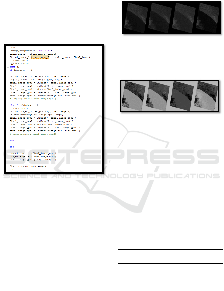
Figure 6: Function for the division of the super image.
Figure 6 represents the division of the super image,
the function receives the super image as an input
parameter, then divides into two images of similar
size, the function returns two images.
Figure 7: Code for CPU execution.
Figure 7 presents the code when operations are
performed on the image, its main characteristic is
that the entire process is carried out in the CPU, in
order to measure performance, a measurement of the
execution time is carried out from the loading of the
image. in memory until the result is displayed on the
screen.
Figure 8: Code for execution on a GPU.
Method for Processing High-Resolution Satellite Images, Based on Multi-GPU Programming
623
In figure 8, the code for the execution of the
processing of the images in the GPU is presented,
with the similar processes as the previous case, with
the difference that it is executed in the GPU that has
as index (1), similar to the process above,
performance is measured by the time it takes
between reading the image and displaying the result.
Figure 9: Code for execution on two GPUs.
In figure 9, the result of the execution in two GPUs
is presented, where the processes are similar, in this
code the parallelization function is called where 2
tasks are executed simultaneously, therefore in each
of the tasks a part of the image, performance is
measured by the time it takes between loading the
image and displaying the results.
3 RESULTS
The results that are presented are grouped in two
ways, the first shows the 6 images that have been
worked in the methodologist's demonstration, and
the second is represented in the times obtained when
applying the three forms of processing. Here are the
images.
Figure 10: First image, made up of 4 colored bands.
In Figure 10, we present the images in their
visualization of the 4 color bands, arranged one after
the other, so that we can work simultaneously with
the 4 color bands.
Figure 11: First image, after being processed.
In Figure 11, we present the images of the 4 color
bands, processed one after the other, showing the
simultaneous processing. Below we present the
results, represented by the processing times obtained
after executing the three forms of processing, the
first processing was performed on the CPU, the
second processing was performed on a GPU and the
third was performed using 2 GPUs, we must Note
that in the three cases, the result of the image
processing is the same in all 3 cases, the only
difference is the time it takes in each one.
Table 2:
Processing times, performed on the CPU.
Satellite
ima
g
e t
y
pe
image
size in GB
Processing
time
(
se
g)
mer
g
ed ima
g
e 0.310 10.42
mer
g
ed ima
g
e 0.850 13.33
image with
separate band
1.17 18.50
image with
separate band
2.1 33.22
panchromatic
ima
g
e
2.5 39.81
panchromatic
ima
g
e
9.4 305.76
In table 2, the results are presented after processing
the images using the first way, which consists of
processing the images entirely in the CPU, in the
ISAIC 2022 - International Symposium on Automation, Information and Computing
624
calculated time it is considered from the loading of
the image in memory, to the visualization of the
result. In the end, the images are sorted in ascending
order so that the larger the image, the longer the
processing time will result.
Table 3: Processing times, performed on the GPU.
Satellite image type image size
in GB
Processing time
(
se
g)
mer
g
ed ima
g
e 0.310 6.00
mer
g
ed ima
g
e 0.850 6.84
image with separate
b
an
d
1.17 10.92
image with separate
b
an
d
2.1 15.29
p
anchromatic ima
g
e 2.5 20.70
p
anchromatic ima
g
e 9.4 200.65
In table 3, the processing performed on a GPU is
presented, with the group of images, in the results
that are observed that the first images have a close
value in the processing time, this characteristic is
due to the fact that it is loaded first the image in
system memory, then the process of changing the
location from system memory to GPU memory is
performed, in larger images the difference in
processing time with processing times is more
noticeable, due to As the image is larger, the image
transfer time is compensated by the processing on
the GPU.
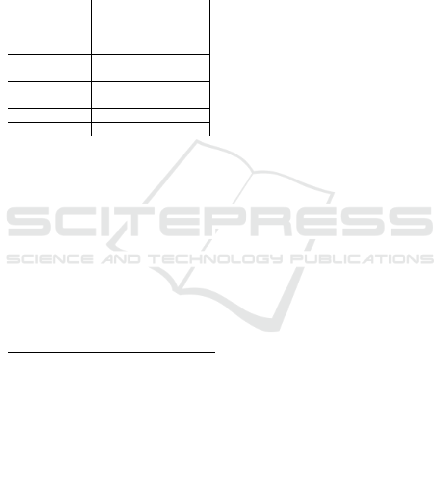
Table 4: Processing times, performed on two GPUs.
Satellite image
type
image
size in
GB
Processing
time (seg)
merged image 0.310 6.52
merged image 0.850 4.75
image with
separate band
1.17 7.45
image with
separate band
2.1 12.16
panchromatic
image
2.5 10.45
panchromatic
image
9.4 105.87
In table 4, the processing times of the images are
presented, considering that they have been processed
in 2 GPUS, a characteristic that in the images of
smaller size, the difference is short with respect to
the processing time when it is done in a single GPU,
because the transfer time between passing the image
from the system memory to the memories of the
GPUs, but this time is compensated with the
processing time, this processing time is considered
negligible when working with images of larger size,
as is the case with the last images.
4 CONCLUSIONS
The conclusions reached at the end of the
demonstration of the proposed methodology, is
organized from three points of reference, the first
from the use of software necessary for the
processing of these images, the second is related
taking as a reference the use of hardware and the
optimization of its use, and the third criterion is
related to the experience acquired in handling the
images regarding the size and weight of the images,
and we finalize with the final recommendations on
the use and processing of satellite images in general,
independent if they are optical, radar or other
images.
Regarding the management of the software, there
are different types of software that work with
satellite images on the market, your choice will
depend mainly on the type of final product that is
required to obtain, in this sense they have a practical
orientation, one of the characteristics to To be able
to work with these, is that they require a workstation
with good computational capacity, there are other
ways of working with images, through the use of
classic programs and compilers, that you can work
with when you have limited computational capacity,
that is When working under these conditions, the
proposed methodology can be of great help, where
we can control the flow of data at the time of
processing.
With regard to hardware management, the
methodology is very helpful, because it presents the
different processing options depending on what is
available, always with the same objective, which is
the optimization of resources, an important
consideration that must be taken, is the
programming language that is developed, for this it
is necessary to know if the library exists to be able to
work with the GPUs, in our case MATLAB was
chosen, because it has the libraries that are
compatible with the NVIDIA brand GPUs. With
regard to the size of the image, it is important to
indicate that the results presented show that it is not
always the best option to process in the GPUs, if it is
Method for Processing High-Resolution Satellite Images, Based on Multi-GPU Programming
625

what is required to have a lower processing time,
this is due to a characteristic of the mode of work,
any image that you want to work first is loaded into
the system memory, that is why if the processing is
carried out in the CPU, the time may be less,
because there is no transfer time of the image
between the memory of the system and the memory
of the GPU, when the image is small, it may be the
case that the processing time may be longer in the
CPU, because of the transfer time. This
characteristic changes considerably when the image
to be processed is very large, because the processing
time compensates for the transfer time, in some
cases being considered negligible, as can be seen in
the last image that has a weight of 9.4 GB.
Finally, we conclude that in the use of satellite
images, it is important to know the characteristics of
the images to be processed, such as image size, this
data is important to be able to choose where it can be
processed, as is the case of the CPU, a GPU or two
GPUs, if the image is less than 1GB in weight can
be processed on the CPU or a GPU, if the size is
larger it is recommended to choose to process it in
the configuration of two GPUs.
We can also indicate that we must know the type
of processing, format and resolution, while the
image is in its original format which is the
GEOTIFF at 16 bits, it can only be worked by
specialized software, to be able to work them it is
necessary to convert them to JPG format of 8 bits,
with which they can be observed with any standard
visualization. When working with satellite images
we must take into account the following: type of
image, type of resolution, type of format, what
hardware I have and finally the choice of software.
REFERENCES
Auccahuasi, W., Sernaque, F., Flores, E., Garzon, A.,
Barrutia, A., & Oré, E. (2020). Analysis of the
chromatic characteristics, on land cover types using
synthetic aperture images. Procedia Computer
Science, 167, 2524-2533.
Auccahuasi, W., Bernardo, M., Núñez, E. O., Sernaque,
F., Castro, P., & Raymundo, L. (2018, December).
Analysis of chromatic characteristics, in satellite
images for the classification of vegetation covers and
deforested areas. In Proceedings of the 2018 the 2nd
International Conference on Video and Image
Processing (pp. 134-139).
Aiquipa, W. A., del Carpio, J., Garcia, J., Benites, R.,
Grados, J., & Flores, E. (2019, October). Analysis of
High Resolution Panchromatic Satellite Images, Based
on GPGPU Programming. In Proceedings of the 2019
2nd International Conference on Sensors, Signal and
Image Processing (pp. 45-48).
Auccahuasi, W., Castro, P., Flores, E., Sernaque, F.,
Garzon, A., & Oré, E. (2020). Processing of fused
optical satellite images through parallel processing
techniques in multi GPU. Procedia Computer Science,
167, 2545-2553.
İ. S. Açıkgöz, M. Teke, U. Kutbay and F. Hardalaç,
"Performance evaluation of pansharpening methods on
GPU for RASAT images," 2015 7th International
Conference on Recent Advances in Space
Technologies (RAST), 2015, pp. 283-288, doi:
10.1109/RAST.2015.7208356.
Wei, J., Ibrahim, Y., Qian, S., Wang, H., Liu, G., Yu, Q.,
… Shi, J. (2020). Analyzing the impact of soft errors
in VGG networks implemented on
GPUs. Microelectronics Reliability, 110.
https://doi.org/10.1016/j.microrel.2020.113648
Bhangale, U., Durbha, S. S., King, R. L., Younan, N. H.,
& Vatsavai, R. (2017). High performance GPU
computing based approaches for oil spill detection
from multi-temporal remote sensing data. Remote
Sensing of Environment, 202, 28–44.
https://doi.org/10.1016/j.rse.2017.03.024
Diprima, F., Santoni, F., Piergentili, F., Fortunato, V.,
Abbattista, C., & Amoruso, L. (2018). Efficient and
automatic image reduction framework for space debris
detection based on GPU technology. Acta
Astronautica, 145, 332–341.
https://doi.org/10.1016/j.actaastro.2018.02.009
Kosmidis, L., Rodriguez, I., Jover, Á., Alcaide, S.,
Lachaize, J., Abella, J., … Steenari, D. (2020).
GPU4S: Embedded GPUs in space - Latest project
updates. Microprocessors and Microsystems, 77.
https://doi.org/10.1016/j.micpro.2020.103143
Guerriero, V. W. Anelli, A. Pagliara, R. Nutricato and D.
O. Nitti, "Efficient implementation of InSAR time-
consuming algorithm kernels on GPU environment,"
2015 IEEE International Geoscience and Remote
Sensing Symposium (IGARSS), 2015, pp. 4264-4267,
doi: 10.1109/IGARSS.2015.7326768.
ISAIC 2022 - International Symposium on Automation, Information and Computing
626
