
An Artificial Intelligence Application for a Network of LPI-FMCW
Mini-radar to Recognize Killer-drones
Alberto Lupidi
1
, Alessandro Cantelli-Forti
1
, Edmond Jajaga
2,*
and Walter Matta
3
1
CNIT, National Laboratory of Radar and Surveillance Systems, Pisa, Italy
2
Mother Teresa University, Skopje, North Macedonia
3
Link Campus University, Roma, Italy
Keywords: Artificial Intelligence, Miniradar, UAS, ATS, Data Assurance.
Abstract: The foundation of Internet Information Systems has been initially inspired by military applications. Means of
air attack are pervasive in all modern armed conflicts or terrorist actions. Thus, building web-enabled, real-
time, rapid and intelligent distributed decision-making systems is of immense importance. We present the
intermediate results of the NATO-SPS project “Anti-Drones” that aims to fuse data from low-probability-of-
intercept mini radars and a network of optical sensors communicating with web interfaces. The main focus of
this paper is describing the architecture of the system and the low-cost miniradar sensor exploiting micro-
Doppler effect to detect, track and recognize threats. The recognition of the target via an artificial intelligence
system is the pillar to assess these threats in a reliable way.
1 INTRODUCTION
Killer drones represent a real threat, today we cannot
not mention them as a surprisingly lethal weapon,
e.g., in the Russian invasion in Ukraine, so far.
Unmanned Aerial system (UAS), which carry
lightweight, laser-guided bombs, normally excel in
low-tech conflicts, have carried out unexpectedly
successful attacks in the early stages of Ukraine's
conflict, before the Russians were able to set up their
air defenses in the battlefield. Commercial-derived,
self-built as a hobby, UAS have long been used for
terrorist attacks on civilians and institutions or used for
other crimes such as weapons infiltration into prisons.
To facilitate the countering of killer-drones and
minimize the risk for people and assets, a NATO SPS
Anti-Drones project 1 has been focalized on the
development of a new concept of a Threat Evaluation
Subsystem (TE) of an anti-drone system able to
detect, recognize and track killer-drones. The project
scope is to progress the state of the art applying mini-
radar technology and signal processing, web data
processing and fusion, for improving real-time
intelligence of the TE subsystem and dramatically
reducing the environmental impact (e.g., ECM
pollution) in an urban environment. The core of the
1
https://antidrones-project.org/, last access 22.08.2022
system architecture is a network of LPI (Low-
probability-of-intercept) mini-radar with FMCW or
noise-like waveform, web-interfaced with on-
demand, fully digital, optical camera-integrated
imaging capability, capable of working in all weather
conditions, to be deployed and appropriately placed
on the ground in the area of the asset to be protected.
Detection, tracking and recognition of UAS with
mini-radar using micro-Doppler features is becoming
more and more popular in last few years as noted in
Guo et al. (2019), Harman (2016) and Huizing et al.
(2019).
The optical part is essential to support correct
classification and tracking of the threat and thus to
minimize false alarms. However, this paper mostly
focuses on the proposed system from the radar point
of view.
Next, the paper is organized as follows. The
system conceptual design is described in Section 2.
System requirements are described in Section 3.
Section 4 describes the developed radar devices.
System implementation detailed design takes part in
Section 5. After the citation of the requirements
needed, some results obtained during a preliminary
measurement campaign are shown and discussed in
Section 6. Section 7 describes the implemented
320
Lupidi, A., Cantelli-Forti, A., Jajaga, E. and Matta, W.
An Artificial Intelligence Application for a Network of LPI-FMCW Mini-radar to Recognize Killer-drones.
DOI: 10.5220/0011590300003318
In Proceedings of the 18th International Conference on Web Information Systems and Technologies (WEBIST 2022), pages 320-326
ISBN: 978-989-758-613-2; ISSN: 2184-3252
Copyright
c
2022 by SCITEPRESS – Science and Technology Publications, Lda. All rights reserved
features extraction process. Finally, the paper
concludes with ending notes.
2 THE CONCEPTUAL MODEL
The solution proposed in Anti-Drones project is based
on the following subsystems:
• A network of LPI polarimeter mini-radar with
wave shape FMCW or noise-like, with low
environmental impact and capability of camera
imaging on-demand, fully digital, easy
reconfigurable and high level of flexibility and
versatility, able to work in all weather conditions,
to be deployed and opportunely positioned (on
ground) in the zone of asset to be protected.
• A data processing and fusion subsystem able to
generate the situational awareness and to enable
the fast detection, recognition and tracking of
the threats within the max time to activate the
neutralization action.
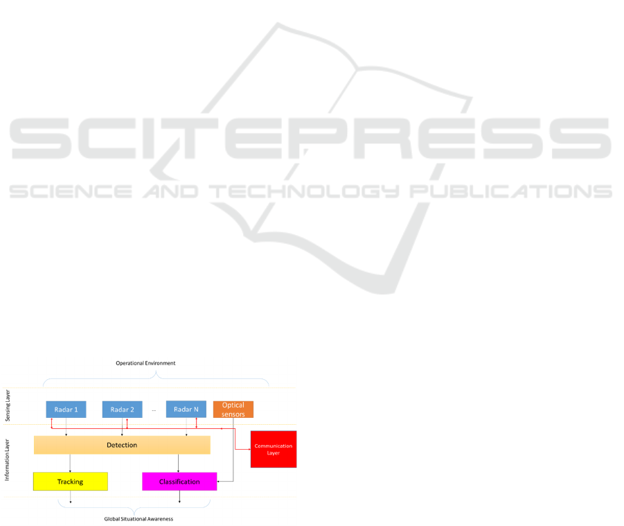
A high-level representation of the system is given in
Figure 1. As can be seen, the sensing layer is
responsible for gathering the information from the
operational environment and it includes all the
sensors involved in the proposed solution. Such
information is passed to the Information Layer that is
responsible to process and transform it in order to get
a global situational awareness of the observed scene.
More specific, such layer include the detection
process and the tracking and classification one. The
algorithm that will be used to fulfil these tasks are out
of the scope of the paper and will be not described
here. The architecture includes also a communication
layer responsible for communicating the gathered
data to the processing unit through Internet protocols.
Well-defined APIs and web services will be used for
each sensor module to support data fusion in the
Information Layer.
Figure 1: Anti-Drones high-level architecture.
3 AIM, REQUIREMENTS AND
OUTLINE
The solution proposed in Anti-Drones project is based
on the following subsystems: Air surveillance is
divided into four phases:
1) Detection
2) Recognition
3) Identification
4) Tracking.
As much for airspace surveillance in general as for
UAS’ detection specifically, the radar surveillance
means remain the primary sources of information in
the predictable future. The significance of optical,
acoustic and laser sensors is anyway rising quickly –
according to technology development. Their mutual
interconnection, interoperability and modularity
should lead to synergic effects reside at minimum in
detection probability rise and false alarms reduction,
as cited in Krátký & Fuxa (2015).
With this project, we foresee a cooperation of
sensors, aiming to a better evaluation of potential
threats.
Several requirements can be assessed in term of
the range needed
• General requirements (in clutter free
environment and for hovering drones);
Detection of the drones: 3km; Recognition:
2.5km
• The range requirements will be subject to the
constraints of the selected scenario that can limit
the radar visibility range. In this case, the
following requirements will be considered the
proper trade-off between the desired ones and
the concept demonstration (in clutter free
environment and for hovering drones);
Detection of the drones: 1.5km; Recognition:
1km
• In the case of moving drones, the following
requirements will be considered the proper
trade-off between the desired ones and the
concept demonstration;
Detection of the drones: between 500m and
1km, according to the flight trajectory, type of
drones and speed; Recognition: 300m.
An Artificial Intelligence Application for a Network of LPI-FMCW Mini-radar to Recognize Killer-drones
321
4 SENSOR PROTOTYPES
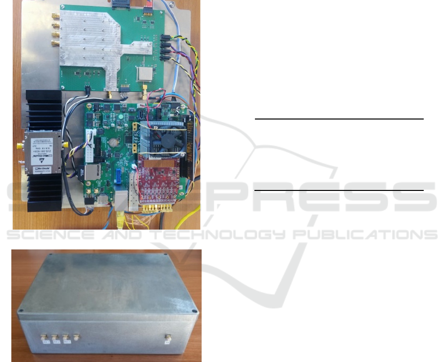
4.1 Radar
The radar sensor developed within this project in
collaboration with Italian company Echoes S.r.l.,
shown in Figure 2, is a multichannel linear frequency
modulated continuous wave (FMCW) radar system
for the detection and recognition of moving targets.
(a)
(b)
Figure 2: (a) radar structure. (b) case with antenna
connectors.
The architecture of this radar consists of one
transmitting and three receiving channels. A fourth
receiving channels can be installed if needed during
further research. The ability to use a fourth channel
allows the use of this hardware to be extended and
also reduce costs to future follow-ons of the ANTI-
DRONES project currently under review by NATO-
SPS offices for the three-year period 2023-2025. The
antennas are external to the main cabinet to allow
different acquisition geometries to be created. In fact,
this configuration allows different radar processing
techniques to be applied. For example, by assuming
that the antennas are correctly positioned, three-
dimensional interferometric inverse synthetic
aperture radar (3D InISAR) algorithms or monopulse
processing can be applied. In addition, several radar
fusion techniques can be exploited in order to
increase the detection and recognition capabilities of
the system. The sensor works at X-Band at 9.6GHz,
with a selectable bandwidth from 300 to 500MHz.
Transmit power is up to 33dBm, with a Noise Figure
of 6dB.
Table 1 shows the maximum range for each RCS
value. In our case, we should have a RCS between -
20 and -10dBm
2
Table 1: Maximum range vs. RCS with 20dBi antenna gain
and 0.5s integration time.
RCS Values Max Range [m]
-30 dBm
2
890.89
-20 dBm
2
1591.59
-10 dBm
2
2822.82
-5 dBm
2
3763.76
4.2 Camera
Optical-based detection, recognition and tracking is
based on real-time optical camera images and
sequences. This process is implemented with deep
learning (DL) methods, providing the target class, the
corresponding bounding box and accuracy rate, as
described in Jajaga et al. (2022). Namely, the camera
detection and recognition components are
implemented with the popular DL framework
YOLOv4 as explained in Bochkovskiy et al. (2020).
The model is trained following a fine-grained
methodological approach for refining the dataset
based on a number of open drone datasets.
5 IMPLEMENTATION
This section describes in more detail the processing
chain of the TE system. The flowchart shown in
Figure 3 emphasizes the dual path needed for a
reliable detection and recognition. In general, optical
and radar systems will operate together in order to
increase the probability of success in the recognition
chain. Moreover, an information fusion system will
WEBIST 2022 - 18th International Conference on Web Information Systems and Technologies
322
recommend the end user with a proposed decision to
be taken as the final operative decision.
The processing flow is the following:
1) Noise mitigation with 2D Wiener Filter
2) Moving Target Indicator (MTI) filtering to
remove clutter and radar artefacts
3) Detection of the body of the drone via CFAR
filtering
4) Kalman Filter Tracking (useful only if
multiple tracks are present), made on
subsequent data batches
5) Recognition via feature extraction (number
of blades, micro-Doppler spectrum shift)
The camera module will use the detection details
from the radar module to initiate the recognition and
tracking process of the target. Namely, for each radar-
detected target, the camera will accurately and
quickly the position in the direction of the moving
target. Radar data to support camera recognition and
tracking include the following: the target angle, the
height where it is located and the speed. The two
branches will work separately achieving their
objective.
However, the success of a single system is not
given for granted. It must be noted that the system
performance gets affected on several operating
environment circumstances, such as: day vs night,
rain vs sun, distance of the target, colour of the target,
intrinsic resolution of the sensor, etc. Given these
issues, we need a final step where we fuse the
decision achieved from the two sensors, together with
the confidence level and the possible knowledge of
false alarms.
Typically, this step is needed for confirming
sinergically the decisions of either branch, or to
overcome shortcomings of one of the two, when
particularly adverse conditions for a specific sensor
arise. Thus, in our approach the data fusion module
will be performed in heterogeneous and
homogeneous manners.
Namely, the system must fuse together
heterogeneous radar and camera data, while also
supporting fusing of homogeneous data from the
corresponding data source. Specifically, our solution
will fuse the following target attributes based on two
sensor sources:
1) Radar data: Direction of arrival, range,
angular coordinates elevation and radar
cross section.
2) Optical camera data: photo and video
images.
Figure 3: Processing Flowchart.
Data Assurance techniques for maximum
confidence in data quality are also ensured. Data from
the sensors are saved in a RAW format so phenomena
of bit-rot (the decay of electromagnetic charge in a
computer's storage) or bit-flip could alter present or
future analyses on the data collected during the trials.
For this reason, a highly resilient long-term storage
solution was chosen to avoid any impediment to the
pace of research. Such a solution inspires the so-
called next-generation "black boxes" (i.e., EVENT
DATA RECORDER) and is based on cryptographic
filesystems and Merkle trees as cited in Cantelli-Forti
& Colajanni (2019). The proposed solution has
periodic and on-the-fly self-diagnosis and self-
healing capabilities. The maximum throughput
currently achieved is 2 GB/s and ready for the next
stages of SPS-AntiDrones research.
6 EXPERIMENT DISCUSSION
The aim of the campaign was primarily to assess the
possibility of recognition of small drones and
medium-sized drones. The second objective is to
assess the possibility of tracking such UAS in a noisy
environment, and finally, to assess the possibility of
recognition among different types of UAS.
Figure 4: Photos of the hexacopter (left) and quadcopter
(right).
RCS Model
Optical Model
Co herent Imaging
Radar Detection
and Tracking
Camera
Detection and
Tracking
Recognition
Recognition
Decision
Fusion
Assessment &
Action
Dynamic
/Payload
Model
UAV plus
payload image
database
An Artificial Intelligence Application for a Network of LPI-FMCW Mini-radar to Recognize Killer-drones
323
The observation campaign was performed in a
mostly building and tree free area, where the main
source of clutter came from short grass, mainly from
the sidelobes of the radar, whose orientation was
slightly toward the sky.
Two UASs, a hexacopter and a quadcopter were
used as a test target as shown in Figure 4.
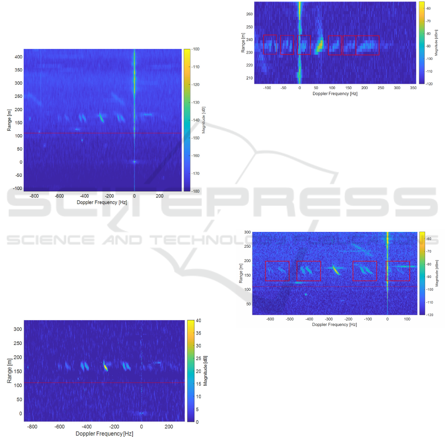
As an example, on a generic UAS, first step deals
with noise reduction. A 7x7 Wiener filtering was
performed. The drawback of this procedure is that
there is a little loss in resolution, so if the target is very
small, is probable that only a single point can be
detected, and this can be detrimental for recognition.
Figure 5: Range-Doppler map after smoothing.
Figure 5 shows the result of the smoothing
operation, while several artefacts and the clutter are
still visible. Figure 6 shows the result of MTI
filtering, which enhances the target and the blades
(moving parts) while cutting clutter and artefacts. Red
lines represent minimum and maximum limits for
correct detection.
Figure 6: Detail of Range Doppler map after MTI.
Figure 7 shows the results for the hexacopter. It is
interesting to observe, as shown in Figure 7, the
contribution for recognition given by the blades. A
total of six contributes from the six blades are visible,
three to the left and three to the right (highlighted in
red boxes). Usually, for a helicopter drone, for
symmetry reasons half of the rotors are in front of the
body (the signatures at the left) and half are on the
back (signatures on the right) with respect to the line
of sight. The image lacks more detail for further
identifications, but with the next images, ulterior
details will be more visible. The Doppler distance
between blades signature is about 50Hz.
Figure 7: Detail of drone body and blades for the
hexacopter.
Being it a quadcopter, we have four blade
signatures, as can be seen in Figure 8. It is interesting
to see that each of the signature of the blades has two
separate contributes. This happens because the
rotating movement of a blade makes that a part of it
moves away from the radar, and one moves toward
the radar, inducing two different micro-modulation
effects.
Figure 8: Detail of drone body and blades for the
quadcopter.
Moreover, two blades compose each blade group,
so it is possible to see that for each blade signature
group there are four lines, divided into two couples,
by accounting for the movement of each half of a
blade itself. The Doppler spacing is about 150Hz.
7 FEATURE EXTRACTION WITH
AI
The micro-Doppler signature of the blades of a UAS
(which travel at high speeds) provides an effective
WEBIST 2022 - 18th International Conference on Web Information Systems and Technologies
324
mechanism, which can discriminate targets from
objects from nature with similar characteristics, such
as birds, and differentiating between UASs.
Spectrogram is the most popular technique for
micro-Doppler analysis, as it is simple and able to
reveal the time-frequency variation of spectral
content. The spectrogram is the squared magnitude of
short-time Fourier transform (STFT), where the
STFT is done by segmenting the raw data into a series
of overlapping time frame and performing FFT on
each time frame
The clustering is performed with the spectrogram.
For each cluster, the sum of within-cluster matrix 𝐒
𝐰
and between-class matrix 𝐒
𝐛
is calculated and the
Fischer Discriminant Analysis is conducted again
(further subspace reliability analysis). The
application of between-class matrix can greatly
improve the discriminability of different classes.
Finally, the Mahalanobis distances of all training
samples to the centre of each cluster of two class are
calculated, which then undergo a min-max
normalization and are taken as the training features
feeding to the classier for model training. Here, the
Support Vector Machine (SVM) is used as the
classifier
The extracted features from the data are:
• Base velocity or body radial velocity.
• Total BW (Bandwidth) of Doppler signal.
• Offset of total Doppler.
• BW without micro-Doppler.
• Normalized standard deviation Doppler sig.
strength
• Cadence/cycle frequency.
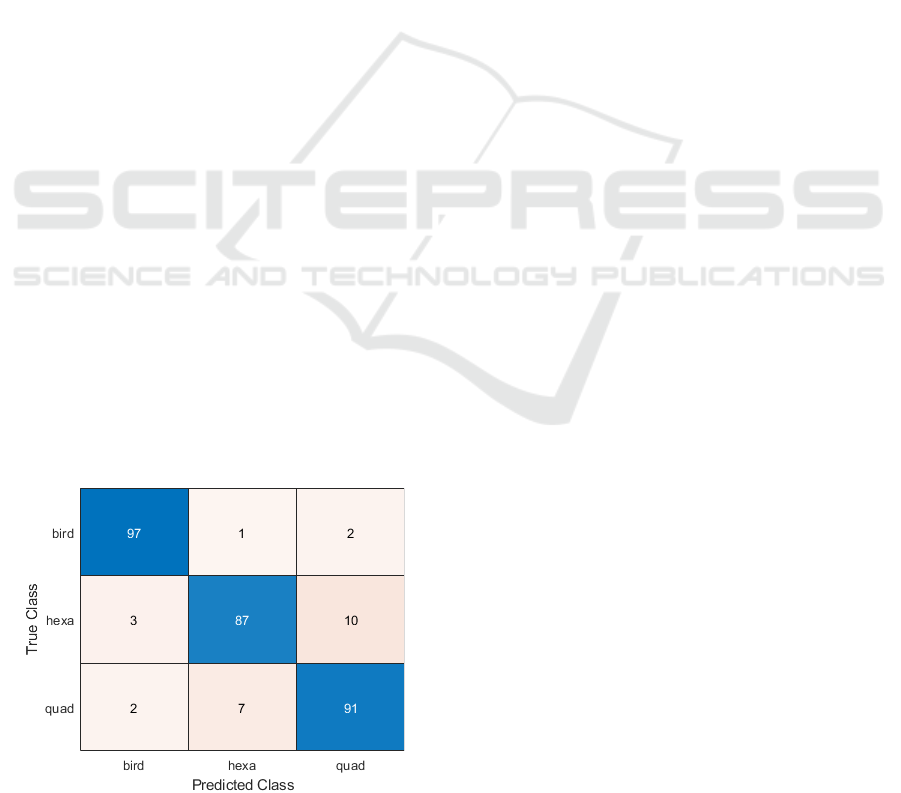
The SVM is able to correctly classify most of the
target and false alarms are higher only when
comparing, as expected, quadcopter and hexacopter,
as shown in the Confusion matrix in Figure 9.
Figure 9: Confusion matrix from SVM.
At the project status, a thorough comparative
evaluation with the optical system is still running, but
the final aim of the project itself is the merging of the
two system in order to overcome each shortcoming.
Also, a more extensive database is needed to train
better the classification system to be more efficient
for different non-cooperative scenarios.
8 CONCLUSIONS
In this paper, a solution to monitor a scenario where
potential threats posed by armed drones is proposed
by combining a network of low-power low-cost
FMCW radar and optical sensors. In this work, it was
analysed principally the radar solution, and after an
overview of the system, the results of a preliminary
measurement campaign showing the feasibility of the
solution. It has been shown how it is possible to detect
even low RCS target, given a reasonable range, and
how from the data acquired is even possible to detect
different features of different drones exploiting
micro-Doppler effects, giving also information on
rotor numbers, number of blades and rotation speed.
Future work should demonstrate how the
performance of the TE subsystem could be improved
by the development of an AI-framework (i.e.
algorithms, methodologies and techniques) on sensor
signal processing, such as radar signals and EO/IR
images, and target trajectories to enable the multi-
targets’ detection, classification and tracking.
ACKNOWLEDGEMENTS
This work was funded by NATO SPS Programme,
approved by Dr. A, Missiroli on 12 June, 2019,
ESC(2019)0178, Grant Number SPS.MYP G5633.
NATO country Project Director Dr. A. Cantelli-Forti,
co-director Dr. O. Petrovska, and Dr. I. Kurmashev.
We would like to sincerely thank:
• Dr. Claudio Palestini, officer at NATO who
oversees the project;
• Prof. Walter Matta, member of the external
advisory board, for tutoring the authors.
REFERENCES
Guo et al. (2019). ‘Micro-Doppler Based Mini-UAV
Detection with Low-Cost Distributed Radar in Dense
Urban Environment’, in 2019 16th European Radar
Conference (EuRAD), Oct. 2019, pp. 189–192.
An Artificial Intelligence Application for a Network of LPI-FMCW Mini-radar to Recognize Killer-drones
325

Harman (2016) ‘Characteristics of the Radar signature of
multi-rotor UAVs’, in 2016 European Radar
Conference (EuRAD), Oct. 2016, pp. 93–96.
Huizing et al. (2019) ‘Deep Learning for Classification of
Mini-UAVs Using Micro-Doppler Spectrograms in
Cognitive Radar’, IEEE Aerospace and Electronic
Systems Magazine, vol. 34, no. 11, pp. 46–56, Nov.
2019, doi: 10.1109/MAES.2019.2933972.
Krátký & Fuxa (2015) ‘Mini UAVs detection by radar’, in
International Conference on Military Technologies
(ICMT) 2015, May 2015, pp. 1–5
Jajaga et al. (2022) An Image-based Classification Module
for Data Fusion Anti-Drone System'. In: 5th
International Workshop on Small-Drone Surveillance,
Detection and Counteraction Techniques, in
conjunction with 21st International Conference on
Image Analysis and Processing (ICIAP), 2022, 23-27
May, Lecce, Italy [unpublished, accepted for
publication]
Bochkovskiy et al. (2020) Optimal speed and accuracy of
object detection. arXiv 2020, arXiv:2004.10934.
Cantelli-Forti & Colajanni (2019) Digital Forensics in
Vessel Transportation Systems. In International
Symposium on Foundations and Practice of Security
(pp. 354-362). Springer, Cham.
WEBIST 2022 - 18th International Conference on Web Information Systems and Technologies
326
