
Digitization of Landmark Training for Topographical Disorientation:
Opportunities of Smart Devices and Augmented Reality
Tom Lorenz
1 a
, Mirco Baseniak
1 b
, Linda M
¨
unch
2 c
, Ina Schiering
1 d
and Sandra Verena M
¨
uller
2 e
1
Faculty of Computer Science, Ostfalia University of Applied Sciences, Wolfenb
¨
uttel, Germany
2
Faculty of Social Work, Ostfalia University of Applied Sciences, Wolfenb
¨
uttel, Germany
Keywords:
mHealth, Landmark, Augmented Reality, Smart Devices, Usability, Privacy, Topological Disorientation.
Abstract:
Navigational abilities and wayfinding are important skills for participation in society. Landmark-based naviga-
tion is considered as an important basic wayfinding strategy. This strategy is used as the underlying concept for
a rehabilitation training for people with topological disorientation. A digitization of this approach is proposed
based on a smartphone application employing Augmented Realty concepts. This application allows to describe
routes based on landmarks and a training of the defined routes. It is developed in an agile, interdisciplinary
research process taking especially usability and privacy aspects into account.
1 INTRODUCTION AND
BACKGROUND
Navigational ability is typically an individual-related,
developed skill, affected by multiple factors like age,
sex, level of education and even emotional states.
Daily problems that might occur during wayfinding
are often solved intuitively by continuing to walk un-
til a familiar or characteristic place has been recog-
nized. During the process of navigation spatial in-
formation is perceived from multiple types of sensors
(e.g. visual, vestibular, proprioceptive). Further many
cognitive functions contribute to wayfinding like vi-
sual perception, short- and long-term memory, men-
tal images, attention, awareness and executive func-
tions. Two perspectives are important during this pro-
cess: The egocentric perspective describes if objects
are perceived from a personal and local point of view,
while the allocentric perspective considers relations
between objects (e.g. the school is north of the li-
brary). These perspectives do not exclude each other
but have complementary roles that interact with each
other (Claessen, 2017).
a
https://orcid.org/0000-0001-9594-7683
b
https://orcid.org/0000-0003-2599-864X
c
https://orcid.org/0000-0002-7711-7421
d
https://orcid.org/0000-0002-7864-5437
e
https://orcid.org/0000-0003-4450-9936
Further strategies for wayfinding, based on dif-
fering knowledge, are ranging from basic landmark
based navigation to route knowledge, up to a survey-
level navigation (Gupta et al., 2020).
Navigational problems are often caused by exter-
nal factors. Moreover primarily people with cogni-
tive impairments have difficulties in orientation and
wayfinding due to problems with, or lack of spatial
skills. Often less intuitive problem solving strategies
are used when a person gets lost, e.g. no alternation of
the current route, or not taking alternative routes into
consideration at all (Delgrange et al., 2020). Since
wayfinding relies on many different cognitive abili-
ties, research has been very complex and not well-
advanced (Sohlberg et al., 2007; Gyselinck et al.,
2009). Difficulties can result from limited concen-
tration abilities, changes in context (e.g. construction
works) or discomfort of being lost resulting in a pas-
sive attitude. Additionally, map-like perspectives re-
quire a substantial mental transfer. Consequences are
anxieties resulting in avoidance of moving indepen-
dently and developing even more dependencies for
being accompanied (Gupta et al., 2020).
Different types of impairments concerning
wayfinding exist and were classified by (Claessen,
2017) to their underlying category. Landmark-based
navigation impairment includes difficulties with
processing landmarks, or environmental sceneries.
Further location-based navigation impairments exist,
Lorenz, T., Baseniak, M., Münch, L., Schiering, I. and Müller, S.
Digitization of Landmark Training for Topographical Disorientation: Opportunities of Smart Devices and Augmented Reality.
DOI: 10.5220/0010980500003123
In Proceedings of the 15th International Joint Conference on Biomedical Engineering Systems and Technologies (BIOSTEC 2022) - Volume 5: HEALTHINF, pages 727-734
ISBN: 978-989-758-552-4; ISSN: 2184-4305
Copyright
c
2022 by SCITEPRESS – Science and Technology Publications, Lda. All rights reserved
727
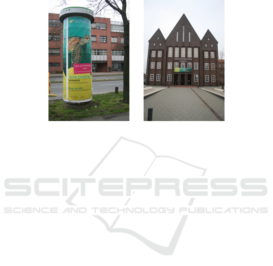
(a) Bad landmark due to similarity and
short lifespan.
(b) Good landmark due to cultural her-
itage and longevity.
Figure 1: Differences between good and bad landmarks.
where difficulties occur in processing landmark
locations and the relations between them, while being
able to visually identify these landmarks. Patients
struggling with connecting locations to another show
a path-based navigation impairment. Problems recall-
ing paths in new, as well as in familiar environments
are prominent. Furthermore patients rely only on
spatial information resulting in distorted maps and
inaccurate description of routes similar to patients
with location-based navigation impairments. Lastly
navigation impairment might occur due to other
conditions e.g. spatial disorders, neglect, deficits
in visuospatial perception, spatial disorientation,
memory impairment, etc.
As already mentioned, research about people with
cognitive impairments is limited as well as research
regarding rehabilitation. Missing knowledge is re-
sulting in a lack of effective rehabilitation training,
that meets spatial demands (Sohlberg et al., 2007;
Gyselinck et al., 2009). Since many cognitive func-
tions are used during navigation, probably not all ar-
eas are affected by impairments and could be used and
trained for compensation. Present approaches rely
on investigating defined routes instead of focusing on
conveying universal wayfinding strategies (Claessen
et al., 2016).
Landmarks are an important basic concept for
wayfinding and provide a great potential for naviga-
tion services (Amirian and Basiri, 2016). Some tar-
get groups, like people with intellectual disabilities
(Gupta et al., 2020), have in addition problems in
identifying reliable landmarks.
In the following sections we will concentrate on
landmark based navigation as a central basis for
wayfinding.
Good landmarks are long-living, preferably with a
high visibility and have a distinctive appearance (see
Figure 1(b)). On the other hand bad landmarks are
characterized by high interchangeability and a short
life span while being often very eye-catchy or not be-
ing distinguishable at all (see Figure 1(a)). The qual-
ity of environmental elements qualifying as good or
bad landmarks has already been discussed in (Lorenz
et al., 2021).
Classical approaches for landmark training rely
on people using printed and laminated pages with
step by step instructions. Usually these instructions
were written in simple language containing pictures
of buildings close by and arrows to indicate direc-
tions. Slight changes in appearance or differences
in positions are already problematic due to posi-
tional changes, different lighting conditions or sea-
sonal changes. If uncertainties arise, a supporting per-
son will be called because of the anxiety of being lost
triggered by e.g. a building painted in a different color
or similar changes while other identifying features re-
mained unchanged.
Nakamura and Ooie (Nakamura and Ooie, 2017)
tested the improvement of supporting public transport
via pictures of the surrounding area via smartphone,
providing additional feedback to reduce nervousness.
Smartphones are already widely used and their in-
fluence is growing. In addition smartphones are also
common among people with intellectual disabilities
HEALTHINF 2022 - 15th International Conference on Health Informatics
728

(Morris et al., 2017) and offer a wide variety of sen-
sors as well as functions, eliminating the need of spe-
cialized hardware, e.g. smartglasses as the Hololens.
Therefore a huge potential exists to use these al-
ready existing devices to support wayfinding and cre-
ate training applications.
In this context we are focusing on people with
intellectual disabilities as they often suffer from ex-
ecutive dysfunctions, struggle with attentiveness and
are easily overwhelmed. An approach for a landmark
training using mobile devices (smartphones) is pro-
posed. Augmented Reality (AR) will be used to re-
duce mental barriers. In this paper the prototype of
such an application is described including the creation
of routes and the following training mainly based on
landmarks.
2 RELATED WORK
Nowadays smartphones are the foundation for sev-
eral navigational applications, e.g. Google Maps,
Apple Maps, OpenStreetMap, etc. Typical parts of
such turn-by-turn navigational systems can be cate-
gorized as positioning, planning and communication.
While communication mostly relies on map views
and instructions including information concerning the
distance to the next turn, adapted approaches using
Augmented Reality (AR) already exist (Rehrl et al.,
2012). People with disabilities are often not able to
use these classical approaches and further problems
with maps and the mental transfer between places,
corners and the real world arise (Delgrange et al.,
2020). Additionally first approaches based on land-
marks as central elements are proposed by Gupta et.
al. (Gupta et al., 2020). Navigational systems for peo-
ple with disabilities exist as well, but are mainly fo-
cused on visual impairments resulting in audible feed-
back (Rivest et al., 2018; Davies et al., 2010). One
approach features Global Navigation Satellite System
(GNSS), e.g. GPS based on audible and visual feed-
back supporting people with intellectual disabilities
going by bus, further showing current environmental
features to reduce insecurities and emphasize on the
correct bus stop (Davies et al., 2010). Augmented re-
ality brings new potential to navigational systems em-
ploying high quality tracking due to the use of visual
odometry (Yoon et al., 2019). Additionally to ease the
complexity of mainly relying on visual odometry for
localization, markers (Fusco and Coughlan, 2018; El-
gendy et al., 2019) as well as beacons (Delnevo et al.,
2018) can be used typically indoors, while GNSS can
be employed outdoors.
Due to the nature of AR enriching the view with
additional elements, navigational approaches using
AR outperform classical approaches in comprehen-
sibility for people with (intellectual) disabilities re-
sulting in less assistance required (McMahon et al.,
2015). With the help of AR barriers can be low-
ered, as well as new possibilities for interventions are
provided, fostering autonomy especially for people
with intellectual disabilities (McMahon et al., 2015;
Smith et al., 2017; Bridges et al., 2020). Additionally
AR has positive effects on learning outcomes (Bower
et al., 2014) and encourages self-regulation as well as
self-determination (Cihak et al., 2016; Smith et al.,
2017). Nonetheless even with AR most approaches
focus on visual impairment (Yoon et al., 2019; Ko
and Kim, 2017; Al-Khalifa and Al-Razgan, 2016; El-
gendy et al., 2019) . In addition, marker are used
for indoor localization (Fusco and Coughlan, 2018;
Elgendy et al., 2019), and also for specific instruc-
tions (Ko and Kim, 2017; Al-Khalifa and Al-Razgan,
2016). Furthermore it was shown, that AR as a tech-
nology provides great potential regarding wayfinding
and orientation (Ko and Kim, 2017). User feedback
is in general very positive (Yoon et al., 2019). Smart
glasses as e.g. the Hololens offer a handsfree AR ex-
perience but are significantly more expensive, often
limited by built in sensor technology (e.g. lack of
GPS sensors) or have to be used in combination with
smartphones. Nonetheless navigational approaches
using smart glasses utilizing tactile, audible and vi-
sual assistance exist, but mainly focus on people with
visual impairments as well (Zhao et al., 2020).
In general landmark based navigation outperforms
turn-by-turn navigation if used by pedestrians. Ap-
proaches using local landmarks, that are only visi-
ble from the current location, are great for new envi-
ronments, e.g. used by tourists (Amirian and Basiri,
2016) but often require object detection, therefore in-
creasing complexity (Wakamiya et al., 2016). Global
landmarks on the other hand are visible from far away
and outperform classical navigation systems as well,
while only showing a general direction, or being vis-
ible itself. The effects of showing a general direc-
tion were investigated by Wenig et. al. (Wenig et al.,
2017) utilizing a smartwatch. Further global land-
marks increase the capability of creating a mental
map while being unmodified and significant.
Lastly the usability for people with disabilities is
considered important. While they are highly moti-
vated to interact with the digital world (Rocha et al.,
2017), usability is essential and dependent on the
quality of the application as well.
Since digitized trainings in the area of landmarks
and wayfinding are promising but were mainly inves-
tigated for people with visual impairments, a train-
Digitization of Landmark Training for Topographical Disorientation: Opportunities of Smart Devices and Augmented Reality
729

ing for people with intellectual disabilities provides a
huge potential.
3 CONCEPT OF
LANDMARK-TRAINING
APPLICATION
Participants tend to rely on poor landmarks, uncer-
tainty, or getting lost. In the following a concept and
prototype for a landmark-based navigational training
is proposed to support autonomous wayfinding. The
application encompasses two central parts: The cre-
ation of routes and the following training of routes.
These two stages are integrated in a mobile applica-
tion. Before participants can train routes, these routes
have to be defined and created in a previous setup-
stage typically in collaboration with a supporting per-
son. A central focus of the work presented here is the
usability from the point of view of people with intel-
lectual disabilities.
3.1 Route Elements
Generally a route consists of a start and a goal with
multiple landmarks in between. While in principle
start and end point could be interchangeable, some
buildings might not be visible from afar or due to
differences in perspectives. Since the application ex-
pects straight lines between points, additional way-
points are introduced, to ensure a better navigation for
e.g. curved roads. Waypoints provide additional in-
formation making the distance between the user and
the designated path more precise. Further it should
be considered whether waypoints could also provide
visible hints for users. Experiences showed that par-
ticipants tend to feel lost when the next landmark is
not directly visible. Therefore using additional land-
marks on curved or even long roads should be consid-
ered, preferably one landmark should always be visi-
ble. All these points are intended to be visualized via
AR markers.
Additionally assistance points are introduced to
mark locations and give hints for safety reasons. As-
sistance points can be reinforced with a short message
that will be displayed if the location is reached. We
emphasize the conciseness of the information with a
strict character limit to ensure conciseness and under-
standability. Furthermore the AR sight of the app will
be disabled and only the message will be displayed
until the area is left. Furthermore a confirmation but-
ton to close the dialog might be needed if no gen-
eral direction is present afterwards. An overview of
specific points and their necessary parameters is pre-
sented in Table 1.
3.2 Route Creation
During the setup-phase preferably a guiding person
walks the route together with a participant. Some ex-
perience with the route might be gained already and
fear could be slightly reduced. Moreover the guid-
ing person should actively involve the participant in
choosing relevant routes and define route elements in
a collaborative manner.
At first a start point has to be defined consisting of
the current location with an associated name. While
walking the designated path, appropriate local land-
marks can be selected and documented in the applica-
tion by pressing the corresponding button (see Figure
2(a)). In addition to a name and positional informa-
tion (via GNSS), a picture of the landmark is required.
Adequate positions might be hard to reach, therefore
not optimally placed points can be altered or refined
via a map view (see Figure 2(b)).
Further along the route landmarks can be iden-
tified and defined via the mobile app by the guid-
ing person in collaboration with the disabled person
while passing by. Also the need of additional way-
points should be directly considered in conjunction
with the participant. Another benefit of having to ac-
tually walk the route together with participants is the
identification of potentially critical traffic situations.
Assistance points could be placed there to give partic-
ipants safety guidance. Lastly upon reaching the des-
tination, a route is completed with a goal marking the
end point of a route. Routes including names, posi-
tions, and additional data as pictures can be altered at
any time. Also the order of points can be changed and
points can be deleted or added to adapt to changes or
to address manual fading-out strategies in the training
process.
All steps of route creation can be prepared in ad-
vance (e.g. taking pictures and checking for sufficient
landmarks) and realized completely in a workspace
environment using a computer, however undergoing
this experience together with participants might lead
to important additional details resulting in a huge ben-
efit during training if routes are created on location.
3.3 Route Training
While supporting and encouraging autonomy in gen-
eral during navigation, we primarily focus on the im-
provement of wayfinding abilities of participants as
well as training of the general concept of landmark-
based navigation and the identification of valid and
HEALTHINF 2022 - 15th International Conference on Health Informatics
730
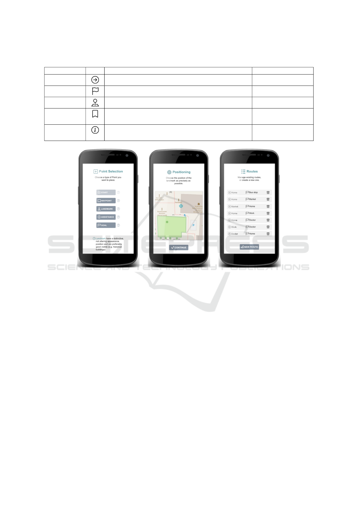
Table 1: Different available points per route and their parameters.
Type of point Icon Description Parameters
Start Start point of a designated route Name, Position
Goal End point of a route Name, Position
Landmark Position of a good local landmark used for navigation Name, Position, Photo
Waypoint Technical, not visible point, that is used by the app
for better route extrapolation (e.g. curved roads)
Position
Assistance Critical point along the route that might need additional
assistance and caution (e.g. crosswalks, crossroads, etc.)
Name, Position,
short message
(a) Selection for different
point types.
(b) Precise adjustment via a
map is possible.
(c) Overview of currently
saved routes.
Figure 2: Different views for route creation landmark-training.
feasible landmarks. To reinforce immersion, land-
marks are embedded into the environment via AR
markers (see Figure 3(b)). This view contains 2 mark-
ers, one for the current landmark and another one for
the end point resp. the next landmark. As soon as
a landmark or the goal of the route is reached, au-
diovisual feedback will notify participants (see Figure
3(c)). The focus of participants should be directed to
long-lasting features and away from eye-catching as-
pects like advertisement.
With the benefit of increased immersion and em-
bedding AR elements into the environment, markers
might be out of sight in the current viewport during
a turn, if a directional change has to be made, or
the smartphone is accidentally facing the wrong di-
rection. To provide further transparency and reduce
the need of searching the surrounding thoroughly if
a marker is not visible in the current view, arrows on
the side of the screen serve as rotational hint.
Although the existence of multiple markers at
a time might be useful, the need of searching for
the next one as well as the amount of information
displayed should be reduced to a bare minimum at
each time to avoid irritation. Nonetheless participants
might leave the designated path unintentionally. If a
certain distance away from the points of the route is
exceeded, a notification will be shown and an arrow
will be pointing back to the route itself, where the
navigation to the next landmark continues. The dis-
tance to the route when sending notifications is crucial
and has to be chosen carefully. Additional waypoints
can support this information for more complex road
design.
Besides leaving the designated route, participants
might not be able to find the route again based on
the guidancy of the application and continue the route
without assistance. To address given circumstances it
is useful to ask the participant if everything is all right
Digitization of Landmark Training for Topographical Disorientation: Opportunities of Smart Devices and Augmented Reality
731
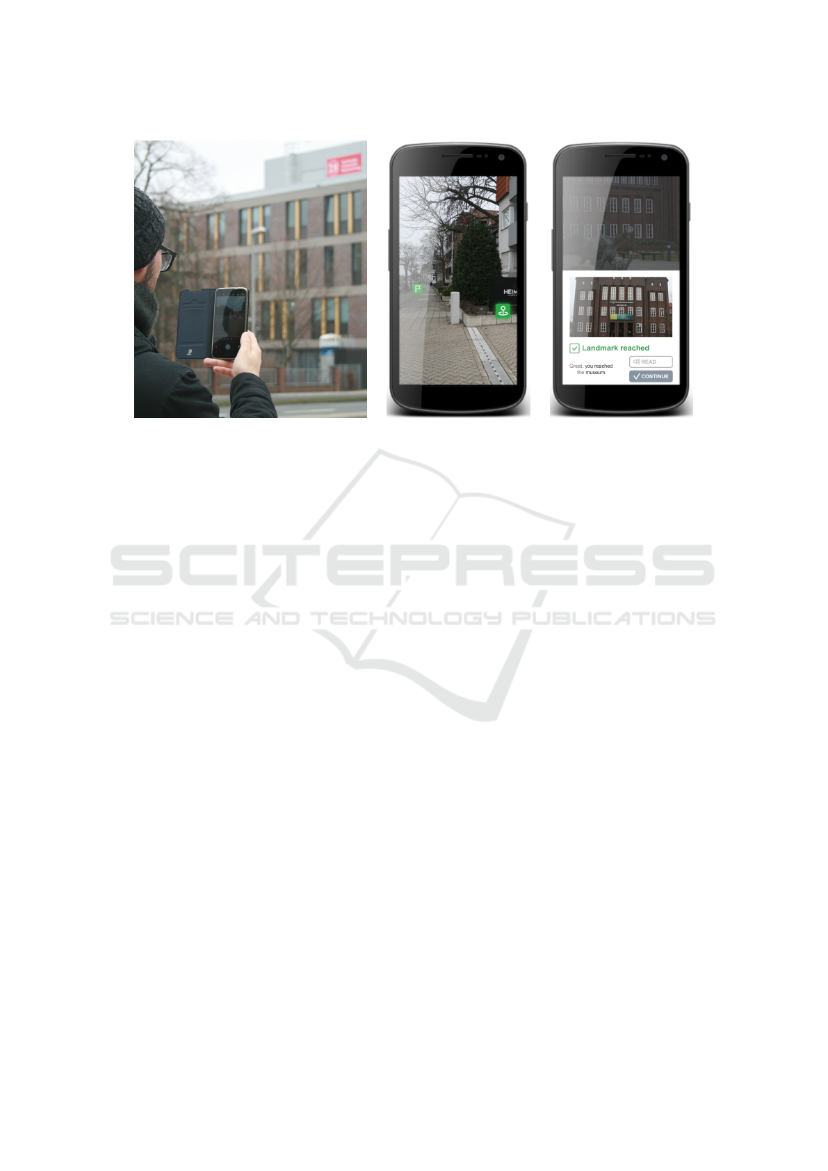
(a) Participant holding smartphone. (b) AR Marker embedded
into environment showing
Landmark and Goal direction.
(c) Notification Landmark
reached.
Figure 3: Views of the landmark-training application.
or help is needed, if no movement is detected. To this
end, the timing is crucial since participants might be
distracted and demotivated by frequent notifications
nor do we want to distract focus from traffic lights or
walk ways. If a participant feels stuck, there will be
a possibility to contact a predefined guiding person.
While a permanent visible help button might be eas-
ily accessible, we abandoned this idea due to potential
over usage or accidental usage.
Due to the intrusiveness of AR, safety is one of
our main priorities. Therefore the application should
be less intrusive and only show a bare minimum of
elements with minor transparency effects to not ob-
struct the vision of the user. Several approaches for
safety measures in AR navigation exist e.g. showing
a safety notification at the beginning of the route, or
locking the whole application while the user is mov-
ing. We decided not to lock the app while participants
move, since stopping every time to assure oneself that
the next landmark is still in the right direction is to
disrupting. Instead we integrated assistance points
that display additional notification that users should
pay attention to the environment right now to use e.g.
crosswalks or wait at traffic lights.
4 DISCUSSION & CONCLUSION
The prototype described here is developed in an agile
approach within an interdisciplinary research group.
All elements in this first prototyping phase were thor-
oughly discussed and conceptualized, but still have to
be evaluated with participants. Results of these evalu-
ations and additional ideas from participants are used
as a basis for further prototypes in the agile develop-
ment.
Another central focus of the research process is
the consideration of privacy for participants via a pri-
vacy by design approach. This is especially impor-
tant for AR technologies. Advanced AR features as
e.g. object detection are mainly realized by sending
the corresponding data to a cloud service where ma-
chine learning based classification tasks are realized,
instead of performing these operations on the smart-
phone itself. Since to this end raw data as photos
or voice recordings are sent to a cloud service, this
raises significant privacy concerns. For this reason an
AR framework that does not employ cloud services is
used. Also for the use of sensor data of smartphones
in general, as e.g. capturing location data or voice
data, privacy risks need to be analyzed and privacy
respecting solutions need to be conceptualized.
People with topological disorientation are often
not able to use classical navigational devices or maps.
Augmented Reality provides a promising alternative
by adding elements directly into the environment
while additionally still being aware of the surround-
ings. While the application can be used as a compen-
sational tool, the training approach has to be evaluated
as well, including fading-out strategies.
The prototype presented here is the basis of fur-
ther participatory research where especially usability
HEALTHINF 2022 - 15th International Conference on Health Informatics
732

and understandability are focused. Aspects for further
improvements might include customizable icons for
start and goal points for better understanding. More-
over based on the current location, routes with a start
point nearby could be filtered beforehand, minimizing
the amount of available routes in the route selection
view significantly. Another important aspect is to fos-
ter the motivation of participants. Here the integration
of gamification elements in the training process will
be considered to be an important area of future work.
ACKNOWLEDGEMENTS
This work was supported by the Federal Ministry of
Education and Research (BMBF) as part of SmarteIn-
klusion (01PE18011C).
REFERENCES
Al-Khalifa, S. and Al-Razgan, M. (2016). Ebsar: Indoor
guidance for the visually impaired. Computers &
Electrical Engineering, 54:26–39.
Amirian, P. and Basiri, A. (2016). Landmark-based pedes-
trian navigation using augmented reality and machine
learning. In Gartner, G., Jobst, M., and Huang,
H., editors, Progress in Cartography, pages 451–465.
Springer International Publishing, Cham.
Bower, M., Howe, C., McCredie, N., Robinson, A., and
Grover, D. (2014). Augmented reality in education –
cases, places and potentials. Educational Media Inter-
national, 51(1):1–15.
Bridges, S. A., Robinson, O. P., Stewart, E. W., Kwon, D.,
and Mutua, K. (2020). Augmented reality: Teach-
ing daily living skills to adults with intellectual dis-
abilities. Journal of Special Education Technology,
35(1):3–14.
Cihak, D. F., Moore, E. J., Wright, R. E., McMahon, D. D.,
Gibbons, M. M., and Smith, C. (2016). Evaluating
augmented reality to complete a chain task for ele-
mentary students with autism. Journal of Special Ed-
ucation Technology, 31(2):99–108.
Claessen, M. H. G. (2017). Lost after stroke: Theory,
assessment, and rehabilitation of navigation impair-
ment. http://localhost/handle/1874/349384.
Claessen, M. H. G., van der Ham, I. J. M., Jagersma, E.,
and Visser-Meily, J. M. A. (2016). Navigation strat-
egy training using virtual reality in six chronic stroke
patients: A novel and explorative approach to the re-
habilitation of navigation impairment. Neuropsycho-
logical Rehabilitation, 26(5-6):822–846.
Davies, D. K., Stock, S. E., Holloway, S., and Wehmeyer,
M. L. (2010). Evaluating a GPS-based transportation
device to support independent bus travel by people
with intellectual disability. Intellectual and Develop-
mental Disabilities, 48(6):454–463.
Delgrange, R., Burkhardt, J.-M., and Gyselinck, V.
(2020). Difficulties and problem-solving strategies in
wayfinding among adults with cognitive disabilities:
A look at the bigger picture. Frontiers in Human Neu-
roscience, 14.
Delnevo, G., Monti, L., Vignola, F., Salomoni, P., and Mirri,
S. (2018). AlmaWhere: A prototype of accessible in-
door wayfinding and navigation system. In 2018 15th
IEEE Annual Consumer Communications Networking
Conference (CCNC), pages 1–6.
Elgendy, M., Guzsvinecz, T., and Sik-Lanyi, C. (2019).
Identification of markers in challenging conditions for
people with visual impairment using convolutional
neural network. Applied Sciences, 9(23):5110.
Fusco, G. and Coughlan, J. M. (2018). Indoor localization
using computer vision and visual-inertial odometry. In
Miesenberger, K. and Kouroupetroglou, G., editors,
Computers Helping People with Special Needs, Lec-
ture Notes in Computer Science, pages 86–93, Cham.
Springer International Publishing.
Gupta, M., Abdolrahmani, A., Edwards, E., Cortez, M., Tu-
mang, A., Majali, Y., Lazaga, M., Tarra, S., Patil, P.,
Kuber, R., and Branham, S. M. (2020). Towards more
universal wayfinding technologies: Navigation prefer-
ences across disabilities. In Proceedings of the 2020
CHI Conference on Human Factors in Computing Sys-
tems, pages 1–13, Honolulu HI USA. ACM.
Gyselinck, V., Meneghetti, C., De Beni, R., and Pazzaglia,
F. (2009). The role of working memory in spatial text
processing: What benefit of imagery strategy and vi-
suospatial abilities? Learning and Individual Differ-
ences, 19(1):12–20.
Ko, E. and Kim, E. Y. (2017). A vision-based wayfind-
ing system for visually impaired people using situa-
tion awareness and activity-based instructions. Sen-
sors, 17(8):1882.
Lorenz, T., Leopold, M., Ertas, F., M
¨
uller, S. V., and Schier-
ing, I. (2021). Landmark training based on augmented
reality for people with intellectual disabilities. In
Stephanidis, C., Antona, M., and Ntoa, S., editors,
HCI International 2021 - Posters, Communications in
Computer and Information Science, pages 498–505,
Cham. Springer International Publishing.
McMahon, D., Cihak, D. F., and Wright, R. (2015). Aug-
mented reality as a navigation tool to employment op-
portunities for postsecondary education students with
intellectual disabilities and autism. Journal of Re-
search on Technology in Education, 47(3):157–172.
Morris, J. T., Sweatman, W. M., and Jones, M. L. (2017).
Smartphone use and activities by people with disabil-
ities: User survey 2016. page 18.
Nakamura, F. and Ooie, K. (2017). A study on mobility
improvement for intellectually disabled student com-
muters. IATSS Research, 41(2):74–81.
Rehrl, K., H
¨
ausler, E., Steinmann, R., Leitinger, S., Bell,
D., and Weber, M. (2012). Pedestrian navigation
with augmented reality, voice and digital map: Re-
sults from a field study assessing performance and
user experience. In Gartner, G. and Ortag, F., edi-
tors, Advances in Location-Based Services: 8th Inter-
national Symposium on Location-Based Services, Vi-
Digitization of Landmark Training for Topographical Disorientation: Opportunities of Smart Devices and Augmented Reality
733

enna 2011, Lecture Notes in Geoinformation and Car-
tography, pages 3–20. Springer, Berlin, Heidelberg.
Rivest, J., Svoboda, E., McCarthy, J., and Moscovitch, M.
(2018). A case study of topographical disorienta-
tion: Behavioural intervention for achieving indepen-
dent navigation. Neuropsychological Rehabilitation,
28(5):797–817.
Rocha, T., Carvalho, D., Bessa, M., Reis, S., and Mag-
alh
˜
aes, L. (2017). Usability evaluation of navigation
tasks by people with intellectual disabilities: A google
and SAPO comparative study regarding different in-
teraction modalities. Universal Access in the Infor-
mation Society, 16(3):581–592.
Smith, C. C., Cihak, D. F., Kim, B., McMahon, D. D., and
Wright, R. (2017). Examining augmented reality to
improve navigation skills in postsecondary students
with intellectual disability. Journal of Special Edu-
cation Technology, 32(1):3–11.
Sohlberg, M. M., Fickas, S., Hung, P.-F., and Fortier, A.
(2007). A comparison of four prompt modes for route
finding for community travellers with severe cognitive
impairments. Brain Injury, 21(5):531–538.
Wakamiya, S., Kawasaki, H., Kawai, Y., Jatowt, A., Ara-
maki, E., and Akiyama, T. (2016). Lets not stare at
smartphones while walking: Memorable route recom-
mendation by detecting effective landmarks. In Pro-
ceedings of the 2016 ACM International Joint Confer-
ence on Pervasive and Ubiquitous Computing, pages
1136–1146, Heidelberg Germany. ACM.
Wenig, N., Wenig, D., Ernst, S., Malaka, R., Hecht, B., and
Sch
¨
oning, J. (2017). Pharos: Improving navigation in-
structions on smartwatches by including global land-
marks. In Proceedings of the 19th International Con-
ference on Human-Computer Interaction with Mobile
Devices and Services, pages 1–13, Vienna Austria.
ACM.
Yoon, C., Louie, R., Ryan, J., Vu, M., Bang, H., Derksen,
W., and Ruvolo, P. (2019). Leveraging augmented re-
ality to create apps for people with visual disabilities:
A case study in indoor navigation. In The 21st Inter-
national ACM SIGACCESS Conference on Comput-
ers and Accessibility, pages 210–221, Pittsburgh PA
USA. ACM.
Zhao, Y., Kupferstein, E., Rojnirun, H., Findlater, L., and
Azenkot, S. (2020). The effectiveness of visual and
audio wayfinding guidance on smartglasses for peo-
ple with low vision. In Proceedings of the 2020 CHI
Conference on Human Factors in Computing Systems,
pages 1–14, Honolulu HI USA. ACM.
HEALTHINF 2022 - 15th International Conference on Health Informatics
734
