
Enriching the Visit to an Historical Botanic Garden with Augmented
Reality
Rafael Torres
a
, Stefan Postolache
b
, Maria Beatriz Carmo
c
, Ana Paula Cl
´
audio
d
,
Ana Paula Afonso
e
, Ant
´
onio Ferreira
f
and Dulce Domingos
g
LASIGE, Departamento de Inform
´
atica, Faculdade de Ci
ˆ
encias, Universidade de Lisboa, Lisboa, Portugal
Keywords:
Augmented Reality, Mobile Applications, Botanical Gardens.
Abstract:
The use of Augmented Reality in mobile guide applications for natural parks and gardens enables compelling
and memorable experiences that enrich visits. But the creation of these experiences is still riddled with several
challenges concerning technology and content production. This paper presents guidelines for the development
of AR experiences in mobile applications that support visits to gardens or natural parks, providing a list of
technological and multimedia content elements that should be considered. We applied these guidelines in the
development of a mobile application for a Botanical Garden, implemented for Android and iOS. We conducted
a study with volunteers during visits to the garden and the results revealed high levels of perceived app usability
and strong agreements about app features, which allow us to accept that the app was evaluated positively.
1 INTRODUCTION
The JBT (Jardim Bot
ˆ
anico Tropical) Garden is lo-
cated in a monumental area of our city, Lisbon, next
to the Mosteiro dos Jer
´
onimos and occupies seven
hectares. The garden provides a rich plant collec-
tion consisting mainly of species from tropical and
subtropical regions. Besides the remarkable natural
heritage and botanic vocation of this Garden, the visi-
tors can also explore the historical buildings and stat-
uary from the 17th to the 20th centuries, observe sev-
eral bird species and a diversity of bryophytes and
lichens. The JBT organizes scientific, educational,
cultural and leisure activities for a varied audience,
such as, tourists, families with children, students, and
botanical experts. These activities are fundamental
to disseminate specialized knowledge on tropical sci-
ence and to highlight and preserve heritage and col-
lective memory concerning a remarkable period in the
History of our country.
Nowadays, it is important to complement the ex-
isting guided tours and explore the available techno-
a
https://orcid.org/0000-0001-6886-8541
b
https://orcid.org/0000-0001-5244-5704
c
https://orcid.org/0000-0002-4768-9517
d
https://orcid.org/0000-0002-4594-8087
e
https://orcid.org/0000-0002-0687-5540
f
https://orcid.org/0000-0002-7428-2421
g
https://orcid.org/0000-0002-5829-2742
logical developments to offer to visitors new interac-
tive and engaging experiences. The use of Augmented
Reality (AR) in mobile guides to enrich visits, namely
adding information to the real world, has been applied
in several projects and domains (Santos et al., 2020;
Andrade and Dias, 2020; Siang et al., 2019; Pombo
and Marques, 2019). Although AR mobile applica-
tions are now widely used, there are still several chal-
lenges related to technology and multimedia content
creation. For instance, how to select the appropriate
tracking method according to the characteristics of the
environment and visitors’ smartphones and how to de-
cide which experiences should be created and associ-
ated to which PoIs (Point of Interest).
Our main contribution is to organize the chal-
lenges and requirements associated with the develop-
ment of AR experiences in mobile applications (apps)
that support visits to gardens or natural parks and to
apply them in an actual app, JBT app, implemented
for Android and iOS.
2 BACKGROUND AND RELATED
WORK
AR makes possible the interaction with the surround-
ing real world, enriching it with a virtual world, where
real and virtual object are combined (Feiner et al.,
1993). Within this context, it is mandatory to track
Torres, R., Postolache, S., Carmo, M., Cláudio, A., Afonso, A., Ferreira, A. and Domingos, D.
Enriching the Visit to an Historical Botanic Garden with Augmented Reality.
DOI: 10.5220/0010897900003124
In Proceedings of the 17th International Joint Conference on Computer Vision, Imaging and Computer Graphics Theory and Applications (VISIGRAPP 2022) - Volume 1: GRAPP, pages
91-102
ISBN: 978-989-758-555-5; ISSN: 2184-4321
Copyright
c
2022 by SCITEPRESS – Science and Technology Publications, Lda. All rights reserved
91

the user’s viewpoint to superimpose virtual contents
over real environment views (Bekele et al., 2018).
AR tracking techniques are used to determine the
current pose (position and orientation) of users in the
environment, enabling the alignment of virtual con-
tent with the physical objects. Tracking techniques
have been categorized as sensor-based, vision-based,
and hybrid (Zhou et al., 2008; Rabbi and Ullah, 2013;
Kim et al., 2017; Siriwardhana et al., 2021).
Sensor-based tracking techniques use sensors that
are placed in the environment or integrated in the mo-
bile device. Different kinds of sensors can be used,
such as optical, acoustic, mechanical, magnetic, in-
ertial, or radio (RFID, Infrared, Beacons, NFC, Wi-
Fi, and GPS) (Jain et al., 2013). Inertial-based track-
ing uses accelerometers and gyroscopes to estimate
the user pose based on previously estimated or known
poses. The accelerometer measures the motion to cal-
culate the position of the user relative to some initial
point. The gyroscope measures the rotation to calcu-
late the orientation of the user relative to some initial
one (Bekele et al., 2018). The compasses uses mag-
netic sensors for orientation, identifying which cardi-
nal point the device is pointing to. An overview of
each kind of sensor-based tracking can be found, for
instance, in (Rabbi and Ullah, 2013).
Vision-based tracking techniques rely on the cam-
era and can use image processing techniques to deter-
mine the current pose. This type of tracking is fur-
ther divided into marker-based and markerless (also
called as natural feature tracking). Early vision-based
tracking was marker-based and used fiducial markers
(artificial landmarks) added to the environment, such
as QR codes. More recently, vision-based tracking
proposals are based on markerless approach, which
allows natural landmarks to be used for tracking, in-
stead of artificial ones. Moreover, Simultaneous Lo-
calization and Mapping (SLAM) algorithms are used
to create maps in unknown environments and, simul-
taneously, to localize users inside them. Virtual ob-
jects are added to the map and shown considering
their position and the user location (Tan et al., 2013;
Klein and Murray, 2007).
Following a different approach, image-assisted
alignment (also named Instant Tracking in (Andrade
and Dias, 2020)) transfers to users the responsibility
for the recognition and the initial alignment. In this
case, a virtual element is shown on the device screen
and the user has to align it with the corresponding real
object which is being captured by the camera of the
device.
Hybrid tracking, also called fusion tracking, com-
bines different tracking techniques to increase track-
ing robustness.
The use of AR in mobile applications for gardens
has been widely evaluated considering the educative
and the visitors experience perspectives (Huang et al.,
2016; Pombo et al., 2017; Harrington et al., 2019;
Pombo and Marques, 2019; Siang et al., 2019; Santos
et al., 2020; Andrade and Dias, 2020; Bettelli et al.,
2020; Harrington, 2020; Santos et al., 2020).
Bekele et al. (2018) identify areas in cultural her-
itage for AR mobile applications and suggest the most
appropriate technology for each case, not covering
the particular case of botanical gardens. Chong et al.
(2021) focus on usability and accessibility challenges
in using virtual reality in cultural heritage.
More aligned with our work, Santos et al. (2020)
define a framework with a set of guidelines for mobile
applications of natural parks. In (Postolache et al.,
2021), the authors systematize a set of requirements
for this type of applications, organizing them in four
main categories, namely, objectives, contents (includ-
ing its organization and presentation), enabling tech-
nology, and other non-functional requirements. While
these proposals present a broader approach, we fo-
cus on the AR experiences comprising the technology
perspective, as well as, the contents perspective.
3 AUGMENTED REALITY FOR
BOTANICAL GARDENS’ VISITS
Developing AR experiences for a botanical garden
gathers people from different backgrounds and raises
several challenges involving technological issues and
content creation. After defining the objectives of AR
experiences, we will present our strategy to the con-
ception of these experiences.
3.1 Objectives
The goal of introducing AR experiences is to enrich
the visit, providing both entertainment and educa-
tional contents in an immersive and interactive way.
In a botanical garden, flora and fauna change through-
out the seasons and the garden may have collections
that evolve over time. Therefore, during a visit, the
visitor has only a glance of the richness of the garden.
With AR, digital information can be added to the im-
age of the real world, thus allowing visitors to observe
elements that might not be visible in the garden at the
time of the visit.
3.2 Conceiving Experiences
To idealize and conceive the AR experiences it is cru-
cial the collaboration between the experts, who know
GRAPP 2022 - 17th International Conference on Computer Graphics Theory and Applications
92

the flora, fauna and the history of the garden, and the
technological team responsible for their implementa-
tion. To motivate the experts and to raise ideas and
awaken their imagination to the requirements of the
AR experiences for the JBT app, our strategy was to
show them examples of what can be done with the
available technology. In the following, we explain the
guidelines established to choose the technology and
the guiding principles to create the contents.
3.2.1 Conceiving Experiences - Technology
When choosing the technology to create the AR ex-
periences we have to consider different aspects, such
as, the tracking techniques that should be suitable for
the experiences, the type of contents that we want
to show and the tools to develop the AR experi-
ences. Considering the ”where”, ”what” and ”how”
questions (Prabhu, 2017) may help us in this pro-
cess. ”Where” is the place of use of the experiences
which is decisive for choosing the methods for recog-
nition and tracking of the AR experiences. ”What” is
the type of content to be shown in AR experiences.
”How” involves the means to implement the AR ex-
periences, namely, the software to be used in the de-
velopment.
In a botanical garden the experiences are used out-
doors which answers the ”where” question. There-
fore, we have to deal with variations in luminosity
over the day and also in the orientation of the shad-
ows cast on objects, which may impose restrictions
in the use of marker recognition. The location and
orientation of the markers need to be carefully stud-
ied to minimize appearance variations throughout the
day. Moreover, these markers should be natural ele-
ments in the garden, like tile panels, avoiding adding
physical artifacts strange to the place.
In outdoor environments, location can be obtained
by a GPS receiver, which provides tracking of user lo-
cation. However, we need to be aware of the lack of
signal in some places provoked by the treetops. Ac-
curacy problems may also occur when the orientation
is provided by sensors integrated in the smartphone,
such as, gyroscope, accelerometer or magnetometer.
Therefore using GPS and other sensors may compro-
mise the correct alignment between virtual contents
and real objects. This type of tracking may be used
when the precision of the alignment between the real
and the virtual objects is not critical.
A more precise alignment may involve the user,
as in the image-assisted alignment, where the user
is asked to perform an initial precise alignment (An-
drade and Dias, 2020).
The set of tracking techniques may be even more
limited. If we want to reach a diverse audience, the
experiences cannot require high-end equipment. This
excludes the use of tracking techniques that require
large amounts of processing power, like SLAM. In ad-
dition, to limit maintenance requirements, we should
avoid resorting to locally placed equipment such as
RFID.
The answer to the ”what” question is not straight-
forward when there is no predefined content associ-
ated with a PoI (detailed ahead). So, ideally, the best
tool is the one that supports the wider variety of con-
tent types (text, image, video, audio and 2D/3D ob-
ject) to allow greater freedom for content creation.
There are several commercial and free AR devel-
opment tools (Bekele et al., 2018), consequently, the
answer to ”how” will depend on the budget, the target
operating system (Android, iOS), the selected track-
ing methods and the type of contents supported.
3.2.2 Conceiving Experiences - Contents
Regarding the contents of AR experiences we have to
consider: the type of media used - it may be text, im-
age, video, audio or 2D/3D virtual models; the goal
of the experience - entertainment, educative or infor-
mative; period of time to which they refer - a snapshot
in time or the evolution over the year.
In any case, the development of the AR expe-
riences needs the contribution and validation of ex-
perts, either based on their scientific knowledge or
daily activities. The garden curators experience year-
round variations in the appearance of plants and the
behaviour of animals in the garden. Nowadays, with
the widespread of mobile phones with good resolu-
tion cameras, it is easy to capture images and videos
at a moment’s notice that reveal the life in the gar-
den. These snapshots may unveil to the visitors what
they may not be able to observe in their visit. Besides,
these live moments, more structured contents may be
created, for instance, to show the evolution over the
year of specific trees.
Animations with 2D/3D models may support sci-
entific explanations of occurrences in the garden or
may be used for entertainment purposes.
4 AUGMENTED REALITY AND
MULTIMEDIA EXPERIENCES
IN JBT
Considering the guidelines presented above, we de-
scribe in this section the technology adopted, the con-
tents gathered and the experiences developed.
Enriching the Visit to an Historical Botanic Garden with Augmented Reality
93

4.1 Conceived Experiences - Technology
In JBT app, as no AR experiences were previously de-
fined, the choice of tools was made towards the ones
with the best possible room for manoeuvre and would
not imply a setback in the solution’s development, es-
pecially in a way that would not jeopardize the com-
pletion of the project.
Hence, it would imply choosing the tool that offers
more functionalities to create the experiences, track-
ing techniques for aligning and to use any contents’
type, since we were sure that the ideas would arise as
a result.
Without a budget to be spent on software tools,
we decided to use licensed free or open-source aug-
mented reality tools. EasyAR
1
was chosen for the An-
droid operating system, having a free license, recog-
nition and tracking of marks and images, solving
the questions: ”Where”, being able to recognize any
JBT’s possible object, when you cannot use the GPS
component properly; and the ”What”, being able to
render over the possible objects, text, image, video
and 3D object contents. DroidAR
2
turned out to be
the second choice, complementing EasyAR. It is an
open-source framework for AR on Android, which
we had to modify and contribute with new code to fit
our needs on the creation of the AR experiences. Re-
solving the issues: ”Where”, by allowing the tracking
of the user’s GPS location and rendering text, image,
3D object and playing audio contents in specific GPS
coordinates; and the ”What”, using the inertia and ori-
entation sensors to render the same type of content at
specific points in space to the user, when it is not pos-
sible to have an adequate GPS signal, nor recogniz-
able planes or well illuminated so that the recognition
capabilities of EasyAR can be effective.
For the iOS operating system, we decided to use
its native frameworks: ARKit
3
for recognition and
tracking of marks and images to render over the possi-
ble objects, text, image, video and 3D object contents;
ARKit, SceneKit
4
and CoreMotion
5
using the iner-
tia and orientation sensors to render the same type of
content at specific points in space to the user; finally
AVKit
6
and AVFoundation
7
, to play video or audio
content.
There are cases where the capabilities of EasyAR
and ARKit cannot be effective, with no recognizable
1
https://www.easyar.com/
2
https://github.com/rafaisen/droidar
3
https://developer.apple.com/augmented-reality/arkit/
4
https://developer.apple.com/scenekit/
5
https://developer.apple.com/documentation/coremotion
6
https://developer.apple.com/documentation/avkit/
7
https://developer.apple.com/documentation/avfoundation/
or well-illuminated planes, and a more precise align-
ment is crucial in a specific PoI. So, we created an
image-assisted alignment tool for Android and iOS
with their native frameworks and libraries, capable of
rendering atop the wanted objects the same type of
content described before for each platform needs.
4.2 Conceived Experiences - Content
The development of the JBT app involved a large
group of experts from distinct areas of knowledge to
ensure that all the contents are correct and accurate
from the scientific point of view.
The creation of AR and multimedia experiences
integrated contents from different sources:
• Videos and images collected by the experts who
work or have interest in the thematic areas of the
garden;
• Videos provided by Centro de Ci
ˆ
encia do Caf
´
e
that is an institutional partner of the garden;
• Animations and 2D/3D models produced by stu-
dents;
• Scheduled image collection throughout the year
of a set of iconic trees.
In their daily activities, the curators of the garden
capture images and videos that show the living nature
in the garden. For instance, videos showing speci-
mens that are not easy for the visitor to watch in the
garden, like woodpeckers in a tree hole and a walk
of a squirrel. Moreover, the experts also purposely
prepared videos for the application, like a close up of
the beautiful Bauhinia’s pink flower. The experts also
provided photos of 36 different birds that inhabit the
garden. To match the bird’s images we searched for
each bird’s sound from the public domain to copy-
righted ones and asked each author to use them in the
experiences.
To go beyond what can be seen in the garden, the
visit to the coffee greenhouse can be complemented
with a video that describes the history and the com-
plete process to obtain a coffee drink, since the plan-
tation until the cup of the user. This video combines
3 videos provided by Centro de Ci
ˆ
encia do Caf
´
e and,
resorting to Kdenlive
8
, it includes new frames, which
add the title and the provider’s credits and logo.
Some of the contents of the experiences were pro-
duced by students of master degrees in Informatics
Engineering and Informatics Teaching.
The method that was applied to involve students
derives from previous experiences that also involved
8
https://kdenlive.org/
GRAPP 2022 - 17th International Conference on Computer Graphics Theory and Applications
94

students in the production of virtual models in digital
heritage (Redweik et al., 2017; Cl
´
audio et al., 2017).
A way of rewarding the work of students is to
pose the challenge of producing contents as part of the
evaluation elements of a curricular unit, so that the re-
sult of the work is recompensed with a grade. So, the
themes/proposals were presented in a curricular unit
in the area of modelling and animation (Animation
and Virtual Environments). Additionally, a factor that
has impact in the enthusiasm of the students is that the
garden is part of their own University.
The students created the videos using Blender
9
to learn the three-dimensional features of the tool.
Videos should have two versions, with and without
a green background, so we could choose when creat-
ing the experience the best option. The Android and
iOS AR Component created, and the AR tools use this
green background to make it invisible when recog-
nized and tracked. The EasyAR tool can only make it
possible through the Alpha Channel technique. Thus,
using the video editing software, Kdenlive, the video
was converted to an Alpha Video so that EasyAR
could make the video background invisible. This way,
the immersion of the video in the environment was
guaranteed.
Tile panels in the JBT inspired the creation of lu-
dic videos. Animals depicted in those tiles were re-
produced, animated and associated with their sound
in nature to bring them to life. The vegetation is also
animated simulating the movement with the blowing
wind. Another video created by the students gives life
to a seemingly disorganised tile panel by ordering it
and solving the puzzle.
To observe the evolution of trees throughout the
year a set of trees that show the most changes in
colour and fall of leaves, fruit and flowers over the
year was selected. Therefore, during a year, every
week, a photo session was held with these trees with
the same camera on a tripod, keeping the same posi-
tion, direction and inclination of the camera. In each
session, at least three photos were taken of each tree
with three types of focus and brightness so that when
creating the sequence there could be a wide variety of
choices for the ideal photo.
4.3 Conceived Experiences
The JBT app includes AR and multimedia experi-
ences, being each one available in a particular PoI in
the garden where it really enriches the visit. All these
places where suggested and validated by the experts.
The set of AR and multimedia experiences include:
9
https:/www.blender.org/
• Time-lapses composed by sequences of images
that show the evolution of a tree along the year;
• Animated 2D and 3D models superimposed over
tile panels;
• Virtual images of birds which, through touch, trig-
ger the emission of the respective call or song of
the specie;
• Informative and garden’s natural life videos.
A set of trees whose appearance varies signifi-
cantly throughout the year was selected. In these PoI
a sequence of images, 1 to 5 per month, depending on
the tree changes, shows the evolution of the tree over
the year. The photographs of trees taken throughout
the year passed through a stage of selection and edi-
tion using GIMP
10
graphical editor. This way, the ex-
perience would provide the visitor with a smooth se-
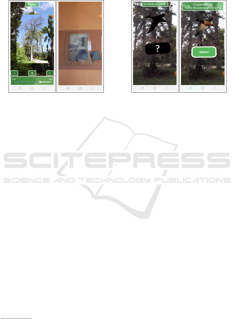
quence of images to feel like a timelapse (Figure 1a).
The user interface allows the visitor to know the
month of the photograph and to control the sequence
of images of the chosen tree. Thus, the user always
has the temporal perception of the sequence. In ad-
dition, three buttons were included, one for play and
pause and two for changing the direction of the se-
quence or manually changing the image. Finally, we
created an interactive seek bar with open-source li-
braries. So, the visitor can interact in different ways
with the sequence of images. The starting month is
the one the user is visiting the garden and ending in
the previous month. The result can be seen in Fig-
ure 1a. Since the appearance of trees varies over time,
image recognition alignment is not recommended. In
addition, sensor-based tracking can also bring inaccu-
racies, which is why we decided to use image-assisted
alignment to ensure the user gets the best time-lapse
experience pointing to the selected trees.
The tiles in the Garden were used as natural marks
to trigger the playback of videos inspired by these
tiles. A target image was created from the tile. This
way, the video can be reproduced exactly on top of
the real object. When appearing in the field of view
of the device’s camera, EasyAR and ARKit will rec-
ognize and reproduce the video. The result can be
seen in Figure 1b.
The AR tools would hardly recognize some tiles
and places in the Garden, whose illumination, shad-
ows or appearance interfere with its recognition. The
image-assisted alignment tool created was used in all
these situations.
Birds may not be the first thing we notice when
visiting a Botanical Garden, but within JBT it is pos-
sible to observe more than 50 bird species. To high-
light the birds that can be observed in different areas
10
https://www.gimp.org/
Enriching the Visit to an Historical Botanic Garden with Augmented Reality
95
(a) Silk Floss Tree time-
lapse experience.
(b) Tile panel AR experi-
ence.
Figure 1: AR experiences.
of JBT we designed an AR experience that associates
birds’ images with the respective call or song. This
experience may be played in different observation ar-
eas and, in each one, with the species which are more
probable to find there. The user is invited to search
around him/her the silhouettes of birds with a ques-
tion mark in the centre of the caption (Figure 2a). By
clicking on the silhouette, it turns into a coloured im-
age, the name of the specie is displayed and the re-
spective sound is played. An informative text box is
presented on the top of the screen with the number of
birds already discovered and the total number of birds
to be discovered, ending with a success message to
congratulate the visitor after all birds have been found
(Figure 2b).
These experiences rely on the sensors of the de-
vice: magnetometer and gyroscope. The silhouette
of the bird is placed where it is more likely to find
a real one, for instance, at the top of a tree, on the
soil or near the lake. To prepare these experiences,
36 photographs of the species more often observed
were edited with GIMP to cut around each bird and
remove the background. Then, they were resized to be
as close to its actual size compared to all other birds’
image sizes.
The audio files obtained for each specie were also
prepared using Audacity
11
: the sound is cut at the
maximum of 20 seconds and the background noise
existing in the various recordings was muffled. Ad-
ditionally, all recordings were placed with the maxi-
mum decibel peaks of -6, leaving approximately the
same volume levels and decibel amplitude.
Besides AR core experiences, some of the col-
11
https://www.audacityteam.org/
(a) Bird silhouette with
question mark.
(b) Mallard image with
its labelled name.
Figure 2: Birds experience.
lected videos already mentioned were associated with
PoI to enrich the visit. It did not make sense to align
these videos with any kind of AR alignment, as they
were not recorded with that purpose. The videos with
longer duration, like the explanation of coffee beans
processing, are presented with an interface that allows
the user to have greater control over the experience: to
know the duration of the content and be able to stop
or choose a part of the video that they want to review,
or even search for the part that interests them most to
freely view.
5 JBT APPLICATION
This section describes the development of JBT app
including the AR and multimedia experiences previ-
ously described and following the set of requirements
associated with the development of mobile applica-
tions to support visits to Botanical Gardens (Posto-
lache et al., 2021).
5.1 Objectives
The JBT app was developed as part of a project by the
Rectory of the University of Lisbon aiming to com-
plement the cultural and educational guided tours and
provide an interactive and engaging experience be-
tween the visitors and the Botanical Garden. The app
offers a guide for visitors providing information about
the main PoIs and provides AR and multimedia con-
tents to enrich the experience of the visitors.
GRAPP 2022 - 17th International Conference on Computer Graphics Theory and Applications
96

5.2 Methodology and Contents
The project followed a User-Centred Design (UCD)
(Abras et al., 2004) and integrated a multidisciplinary
team that included researchers from multiple disci-
plines.
The JBT app development comprised several it-
erations where the app was progressively refined ac-
cording to the feedback of domain experts and users.
The first cycles evolved the design, creation, and val-
idation of low and medium fidelity and the last ones
included the implementation, test, and validation of
the application with end-users.
The application is freely available to Android and
iOS in four languages (English, French, Portuguese,
and Spanish) and can be downloaded without requir-
ing mobile data consumption in certain locations in
the Garden. The application collects authorized de-
mographic data of the visitors and location data dur-
ing the visit to understand the visitor use patterns and
to improve the offered services.
The JBT app was developed for three main groups
of users: tourists; students and experts; and families
with children and offers four different thematic tours:
• “Trees you must see”: includes the 20 most im-
portant and emblematic plants, among the hun-
dreds present in the Garden. For each, it presents
the species name and family, taxonomic notes,
etymology, common names, common uses, geo-
graphic distribution, ecological preferences, flow-
ering and fruiting period, and interesting mor-
phological or reproductive characteristics of the
species, mainly those that can be seen by the visi-
tor;
• “Garden with history”: shows the different his-
torical layers of the JBT and presents informa-
tion about historical buildings and statuary, dating
from the 17th to the 20th century;
• “Birds”: includes information about 36 bird
species that can be observed in the Garden, that
goes from passerines to aquatic species. For each
species, it presents a description, images, species
habitats, curiosities, and details on the probability
of being seen and when does it occur (e.g., if it is
a resident, summer or winter visitor);
• “Biosensors”: presents a large number and diver-
sity of bryophytes and lichens, and their impor-
tance as environmental bio-indicators. For each
species, it shows the description, an image and a
pollution sensitivity scale of each taxa. It includes
24 most common species, 14 species of mosses, 2
species of liverworts and 8 species of lichens.
The rational for the selection of these tours, the
associated PoIs and respective contents, can be found
in (Postolache et al., 2021). In addition to these con-
tents, the three first tours also include AR and multi-
media contents (already mentioned in Section 4).
5.3 Application Overview
This project evolved the development of a mobile ap-
plication for the Botanical Garden with a list of tours
tailored to the various visitor profiles and a back-end
component of the system to manage the contents and
data that are collected and used in the mobile applica-
tion.
As such, the proposed system follows a client-
server architecture. The client component comprises
the various instances of the mobile application run-
ning on the Android and iOS operating systems,
which communicate with the server to synchronize
visitor trajectory (sequence of timestamped locations
points followed by the visitor), demographic data and
to retrieve data regarding tours and associated PoIs.
The NGINX
12
server software dispatches requests
to a web application implemented using the Lumen
Framework
13
. The web application provides a REST
API, enabling client applications to safely access the
data stored in a PostgreSQL database with the Post-
GIS extension to store geographic data.
The JBT app starts with an initial screen with the
available list of tours, and for each, indicates the es-
timated duration and the number of PoIs. Next, the
user can choose a specific tour and access to their de-
scription. All the contents associated with the tour are
dowloaded and the next screen displays a map, an or-
ange dashed line indicating the recommended route
and the icons of the PoIs (Figure 3a). The routes
design took into account several criteria, namely, in-
clusion of the most important PoIs, accessibility and
safety of the visitors, passing through strategic points
(e.g., souvenir shop and cafeteria), and the GPS signal
strength.
The PoIs are represented by coloured icons, sim-
ilar to Google map markers, with a white circle and
a number in the middle to indicate their order in the
tour. Markers are represented without the white cir-
cle, so that the visitor can recognize the PoIs already
visited. At the map screen, the visitors can tap on the
menu in the upper right corner, which gives access
to the list of PoIs or can select a marker to directly
enter the PoI description screen (Figure 3b). To rep-
resent PoIs with AR and multimedia experiences, the
respective marker appears with a green icon drawn at
12
https://nginx.org/
13
https://lumen.laravel.com/
Enriching the Visit to an Historical Botanic Garden with Augmented Reality
97
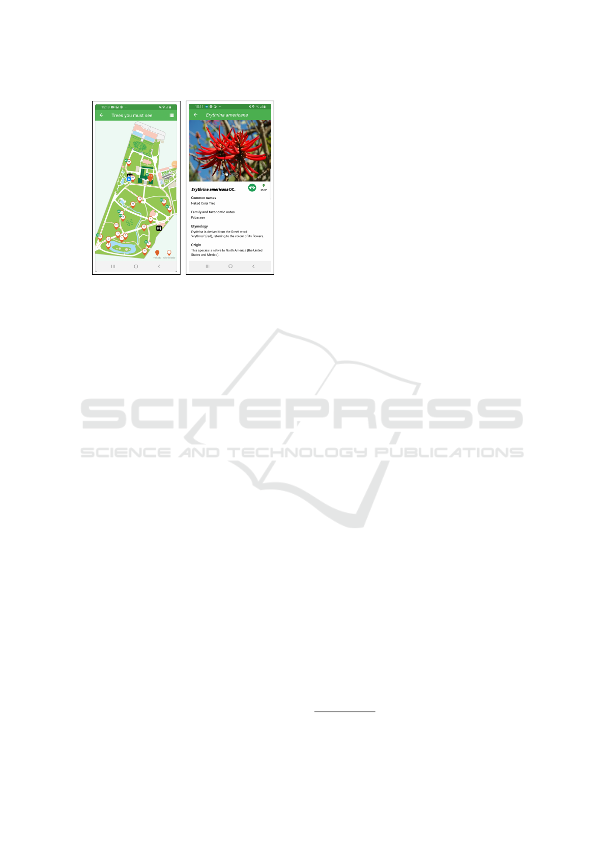
(a) Map of a tour. (b) PoI with AR.
Figure 3: Information about tours and PoIs.
the top of the marker or in the list of PoIs and de-
scription (Figure 3b). The colour palette used for all
application contents, including AR and UI contents
(e.g. PoI markers, icon tours) was chosen in order to
be accessible for people with colour blindness. The
”Garden with history” map screen also has filters to
select only the PoIs associated with a specific histori-
cal period. In ”Birds” and ”Biosensors” tours the PoI
icon represents an area of observation, where is a high
probability of encounter several birds, bryophytes and
lichens species.
5.4 Maps and Positioning Systems
The map view of JBT app is used to represent, for
each tour the PoIs, the recommended route and the
current user’s location. To obtain a map that includes
all important pedestrian paths, buildings, lakes and
other remarkable geographic features with their cor-
rect positions, we analyzed several interactive map
SDKs, such as Google Maps and Open Street Maps
(OSM). We realized that either some paths of inter-
est were not represented, or they were wrongly rep-
resented in shape or position, and it would be neces-
sary to correct and add many regions and paths. Since
this could be a time consuming and paid process (e.g.,
Google Maps) it was decided to implement our own
map of the Garden based on three main sources.
The first source considered was a map in the form
of a shapefile containing accurate data for all the
paths, buildings, lakes and other built objects that
could serve as references for the visitor. This map
has many features, like trees, elevation and buildings
outside the garden which are not relevant to the repre-
sentation of the Garden. The information was trans-
formed from shapefile to SVG using the open soft-
ware QGIS
14
and all the irrelevant details of the map
were removed using GIMP.
Additionally, as some regions and paths suffered
changes during the rehabilitation of the Garden in
2019, we considered another SVG version of the Gar-
den map. Based on this information, we incorporated
the missing features elements, such as paths in the ori-
ental garden, and other paths that lead to the green
houses. In the end, all this information was validated
in loco. Finally, the resulting version was colored us-
ing the color palette from the official map available
at the entrance of the Garden and exported to PNG
format. This format was used instead of the SVG to
support zooming, panning, and overlaying of objects
operations.
The map served also as georeferenced base for the
positioning of the visitor relative to the path and to the
PoIs in the garden. The visitor position and orienta-
tion are represented on the map by a blue circle with
white outline and an arrow in the middle of the circle,
respectively (Figure 3a). The position is calculate us-
ing the GPS receiver and the orientation is obtained
using a sensor fusion algorithm that combines data
from accelerometer, magnetometer and gyroscope to
solve problems of inaccuracy from the magnetic field
sensor and gyro drift
15
.
5.5 Integration of AR and Multimedia
The AR and multimedia experiences are associated
with PoI of the tours “Trees you must see”, “Garden
with history” and “Birds”.
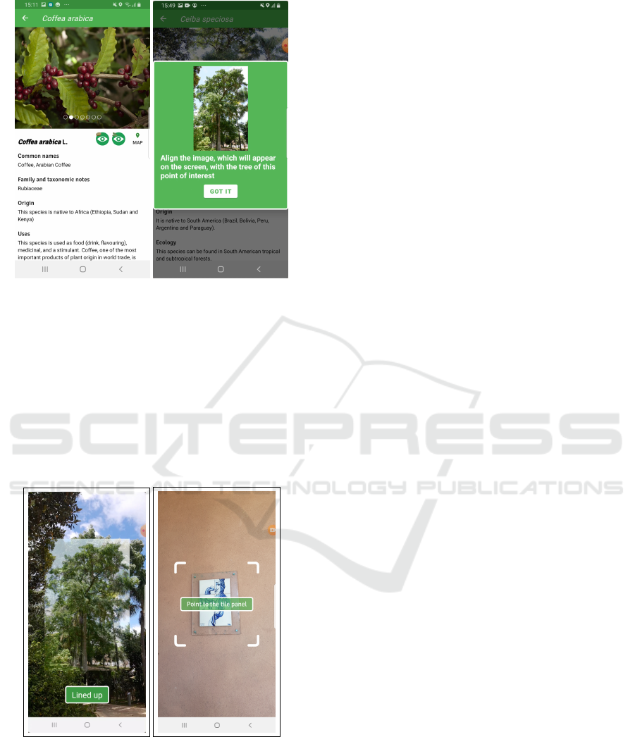
To start any experience it is necessary to click on
an existing green button, already mentioned, on the
corresponding PoI interface, thus making the connec-
tion between the JBT app and the AR Component. A
PoI can be associated with 1 or 2 experiences, each
one with a specific button (Figures 3b and 4a). So
that the user could distinguish which of the experi-
ences he/she wanted to start, small cropped images
relating to those experiences were added to the upper
left corner of the buttons for these experiences.
After selecting the experience, there are instruc-
tion dialogues to guide the user (Figure 4b). When
tracking is performed with image-assisted alignment,
the image of the real-world object is displayed with a
button below showing the text ”Lined up” (Figure 5a).
The user is invited to align the image with the real-
world object and then click on the button to start the
experience.
For tracking with natural markers, a dialogue win-
dow is shown while the target image is not detected.
14
https://www.qgis.org/
15
http://plaw.info/articles/sensorfusion
GRAPP 2022 - 17th International Conference on Computer Graphics Theory and Applications
98
(a) PoI with 2 AR experi-
ences.
(b) An instruction dia-
logue.
Figure 4: AR integration.
In this case, the target image is displayed at the centre
of a transparent PNG image, delimited by 4 corners
marked in white and with an informative text box at
the centre of the screen (Figure 5b). This way the user
is always aware that the camera has not yet capture
the correct alignment and is still needed to point the
camera to the target image. When the target image is
recognized, the dialogue window disappears.
(a) Image-assisted align-
ment.
(b) Image recognition
alignment.
Figure 5: Dialogues for alignment techniques.
6 PRELIMINARY EVALUATION
The evaluation of the JBT app was concerned with
usability, given its intended general user base. To in-
crease the validity of the evaluation, we asked volun-
teers if they would like to visit the garden and try the
app there. In this way, the evaluation was carried out
in a realistic environment and the positioning on the
map and AR features were exercised.
6.1 Participants, Tasks, and Procedure
A total of 39 participants volunteered for the study,
20 female and 19 male, the median age was 23 years,
ranging from 11 to 50 years. The most common
age band was 20–30 years, corresponding to 82% of
the participants. About 74% had an Android mobile
phone and 33% had experience with digital guides. A
convenience sampling was used to select the partic-
ipants, who were recruited from social contacts and
no monetary award was offered, but the admittance to
the garden was free.
During an evaluation trial, participants carried out
tasks covering most features of the JBT app, namely:
selecting a tour; interacting with the map and its PoIs;
using the list of PoIs; reading information about a PoI;
following a tour; applying filters to the PoIs shown on
the map; and interacting with at least one AR experi-
ence of each type.
A trial started when a participant arrived at the gar-
den, after which a brief presentation about the JBT
app was given by a researcher. The participant was
informed about the rights to privacy and to leave at
anytime and then filled out an entrance questionnaire
about gender, age, model of his/her mobile phone, and
experience with digital guides. A training phase came
next, during which the participant was asked to install
the JBT app on the mobile phone and explore it freely,
putting questions if needed. The testing phase com-
prised the tasks mentioned in the previous paragraph
and lasted between 40 and 90 minutes, with a mean
time of 66 minutes. At the end of a trial, the partic-
ipant was given a link to an online system usability
scale (SUS) questionnaire (Brooke, 2013).
At the end of the SUS questionnaire, we added
a block of statements about several features of the
JBT app, that participants evaluated using a five-point
Likert scale. The statements were: 1) it was easy to
choose a tour; 2) the current position and orientation
symbol on the map helped me do the tour; 3) it was
clear on the map the PoIs about which I consulted
information; 4) it was easy to find the list with the
names and images of the PoIs of the tour; 5) the list
with the PoIs of the tour was useful; 6) the organiza-
Enriching the Visit to an Historical Botanic Garden with Augmented Reality
99
tion and presentation of information about each PoI
was adequate; 7) it was easy to see on the map which
PoI have augmented reality experiences; 8) I under-
stood the instructions for performing the augmented
reality experiences; 9) in the “Garden with history”
tour, I found the functionality to filter the PoI perti-
nent; and 10) in the “Birds” tour, in the augmented re-
ality experience, I understood the instructions to look
for the birds. Besides the Likert scale, each statement
had an optional comments field.
6.2 Results and Discussion
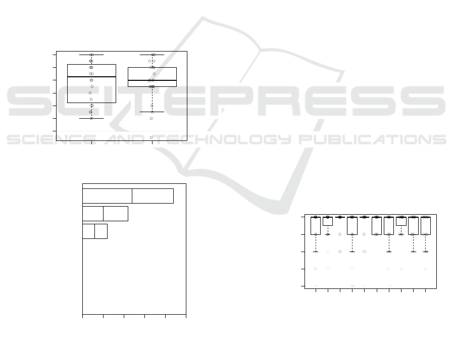
Results from the SUS questionnaire revealed high lev-
els of perceived usability for the JBT app. The median
score was 90.0, which is well above the average SUS
score of about 70 reported in the literature (Brooke,
2013). The boxplots in Figure 6a show a larger vari-
ability of scores around the median for the female par-
ticipants and also that the lowest scores were given by
male participants. Even so, the median scores were
essentially the same for both genders.
●
●
FEMALE MALE
70 75 80 85 90 95 100
SUS SCORE
AVERAGE SUS SCORE
(LITERATURE)
(a) SUS scores by gender.
COUNT
0 5 10 15 20 250 5 10 15 20 25
WORST
IMAGINABLE
AWFUL
POOR
OK
GOOD
EXCELLENT
BEST
IMAGINABLE
0
0
0
0
6
11
22
FEMALE | MALE
ADJECTIVE RATING
(b) Ranking of SUS scores.
Figure 6: Results of SUS questionnaire.
Another way of interpreting the SUS scores is to
convert them using a qualitative rating scale (Bangor
et al., 2009), as shown in Figure 6b. The majority
of scores, were for the “best imaginable” and “ex-
cellent” usability levels, with 56% and 28%, respec-
tively. However, in 16% of the cases, the usability
was “good”, which prompted us to make an analy-
sis of the responses for the individual SUS questions.
We found that the most important causes for the more
modest scores were as follows: lower intention to use
the app frequently; higher need of a technical person
to be able to use the app; and a less favourable opinion
about the integration of the app functions. The two
latter causes could be related to reported difficulties
in locating some PoI, perhaps due to the GPS inaccu-
racy, and in finding app functions, namely the filters
in the “Garden with history” tour.
Regarding the evaluation of the JBT app features
via the ten statements mentioned at the end of the pre-
vious section, Figure 7 shows a strong agreement with
all those statements. Since we always expressed the
statements in positive terms, reflecting our desire that
the app is successful, we can accept that the features
were mainly approved by the participants. To under-
stand why there were disagreements, we analysed the
comments and highlight the following: about state-
ment 2, three participants argued that the map itself
should rotate, not the symbol representing the user;
concerning statement 3, there was one opinion that
a distinction should be made between signaling that
information pages of PoIs were accessed (which can
be done at home) and indicating that PoIs were actu-
ally visited in the garden; on statement 4, three par-
ticipants did not notice or could not find the list of
PoIs; and, finally, about statement 7, the meaning of
the AR experiences symbol (an eye) was not clear for
two participants. We note that less than 8% of the
users point out some less positive detail that will help
us to improve future versions of the app.
●
●
● ●
● ●
●●●●
●●●
●
●
●
●●
●
●
●●
●
●
●
●
● ● ●
STATEMENT ABOUT APP FEATURE
1 2 3 4 5 6 7 8 9 10
STRONGLY
DISAGREE
DISAGREE
NEITHER AGREE
NOR DISAGREE
AGREE
STRONGLY
AGREE
Figure 7: Results of the app features evaluation.
The comments provided by users in the optional
field text reinforce the positive overall opinion re-
vealed by the quantitative questions. Some positive
observations are quite general, but others are more
objective, for instance, appreciating the dynamism of
the experiences, namely the evolution over the year of
GRAPP 2022 - 17th International Conference on Computer Graphics Theory and Applications
100

specific trees. The added value of this app compared
with a traditional guide in paper was also pointed out.
Moreover, some adults that visited the garden with
their children, observed that these were highly enthu-
siastic about the AR experience to find the birds, ex-
periencing it over and over again.
7 CONCLUSIONS
This paper proposes contributions for the creation of
AR experiences in mobile applications for Botanical
Gardens. Conceiving AR experiences for these natu-
ral spaces present specific challenges, namely the se-
lection of appropriate tracking methods for the expe-
riences, the type of multimedia content to be shown
and appropriate development tools. We have applied
these guidelines to the development of the JBT app,
which is already available to visitors. To evaluate the
JBT app, we conducted a user study in loco with sev-
eral participants and the results pointed to an excel-
lent usability and easy to use. Additionally, the par-
ticipants expressed an overall enthusiasm and positive
opinions about the AR experiences and the app con-
tent. The feedback received will help improve future
versions of the app.
Besides JBT app is available for over a year, due
to the pandemic and the difficulty to obtained consent
for data collection, we still do not have a significant
number of visitors. However, with the data already
collected, we are carrying out the analysis of data tra-
jectories, in order to understand the moving patterns
of visitors. We intend to analyse how much time visi-
tors spend in specific locations, the most visited PoIs
or tours, the distribution of visitors, among others.
This information will help the JBT managers to im-
prove the offered services, namely designing person-
alized tours based on the profile of the visitor or new
tours to raise the engagement in guided visits.
Finally, we intend to use the JBT app in a learning
context, aiming to validate the educational value of
the experiences and content, for example, with high
school biology students.
ACKNOWLEDGEMENTS
This work was supported by Universidade de Lisboa
and by FCT through the LASIGE Research Unit, ref.
UIDB/00408/2020 and ref. UIDP/00408/2020. We
also want to thank to the researchers and JBT col-
laborators who participated in this project, Ana God-
inho Coelho, Ana Isabel Leal, C
´
esar Garcia, Maria
Cristina Duarte, Paula Redweik, Palmira Carvalho
and Raquel Barata, to Tiago Ribeiro and Sofia Cruz
for the collaboration in the design of icons, to Pro-
fessor Pinto Paix
˜
ao for mentoring this project, to Dra
Marta Lourenc¸o for her enthusiastic support, and to
all the students who worked in producing AR con-
tents.
REFERENCES
Abras, C., Maloney-Krichmar, D., Preece, J., et al. (2004).
User-centered design. Bainbridge, W. Encyclopedia of
Human-Computer Interaction. Thousand Oaks: Sage
Publications, 37(4):445–456.
Andrade, J. G. and Dias, P. (2020). A phygital approach to
cultural heritage: augmented reality at regaleira. Vir-
tual Archaeology Review, 11(22):15–25.
Bangor, A., Kortum, P., and Miller, J. (2009). Determin-
ing what individual SUS scores mean: Adding an
adjective rating scale. Journal of Usability Studies,
4(3):114–123.
Bekele, M. K., Pierdicca, R., Frontoni, E., Malinverni, E. S.,
and Gain, J. (2018). A survey of augmented, virtual,
and mixed reality for cultural heritage. Journal on
Computing and Cultural Heritage (JOCCH), 11(2):1–
36.
Bettelli, A., Buson, R., Orso, V., Benvegn
´
u, G., Pluchino,
P., and Gamberini, L. (2020). Using virtual reality to
enrich the visit at the botanical garden. Annual Review
of Cybertherapy and Telemedine 2020, page 57.
Brooke, J. (2013). SUS: a retrospective. Journal of Usabil-
ity Studies, 8(2):29–40.
Chong, H. T., Lim, C. K., Ahmed, M. F., Tan, K. L.,
and Mokhtar, M. B. (2021). Virtual reality usability
and accessibility for cultural heritage practices: Chal-
lenges mapping and recommendations. Electronics,
10(12):1430.
Cl
´
audio, A. P., Carmo, M. B., de Carvalho, A. A., Xavier,
W., and Antunes, R. F. (2017). Recreating a medieval
urban scene with virtual intelligent characters: steps
to create the complete scenario. Virtual Archaeology
Review, 8(17):31–41.
Feiner, S., MacIntyre, B., and Seligmann, D. (1993).
Knowledge-based augmented reality. Communica-
tions of the ACM, 36(7):53–62.
Harrington, M. C. (2020). Connecting user experience to
learning in an evaluation of an immersive, interac-
tive, multimodal augmented reality virtual diorama in
a natural history museum & the importance of story. In
6th international conference of the Immersive Learn-
ing Research Network (ILRN), pages 70–78.
Harrington, M. C., Tatzgern, M., Langer, T., and Wenzel,
J. W. (2019). Augmented reality brings the real world
into natural history dioramas with data visualizations
and bioacoustics at the Carnegie Museum of Natural
History. Curator: The Museum Journal, 62(2):177–
193.
Huang, T.-C., Chen, C.-C., and Chou, Y.-W. (2016). An-
imating eco-education: To see, feel, and discover in
Enriching the Visit to an Historical Botanic Garden with Augmented Reality
101

an augmented reality-based experiential learning en-
vironment. Computers & Education, 96:72–82.
Jain, M., Rahul, R. C., and Tolety, S. (2013). A study on
indoor navigation techniques using smartphones. In
2nd international conference on Advances in Com-
puting, Communications and Informatics (ICACCI),
pages 1113–1118. IEEE.
Kim, S. K., Kang, S.-J., Choi, Y.-J., Choi, M.-H., and Hong,
M. (2017). Augmented-reality survey: from concept
to application. KSII Transactions on Internet and In-
formation Systems (TIIS), 11(2):982–1004.
Klein, G. and Murray, D. (2007). Parallel tracking and
mapping for small ar workspaces. In 2007 6th IEEE
and ACM international symposium on mixed and aug-
mented reality, pages 225–234. IEEE.
Pombo, L. and Marques, M. M. (2019). Improving
students’ learning with a mobile augmented reality
approach–the edupark game. Interactive Technology
and Smart Education.
Pombo, L., Marques, M. M., Lucas, M., Carlos, V.,
Loureiro, M. J., and Guerra, C. (2017). Moving learn-
ing into a smart urban park: students’ perceptions of
the augmented reality edupark mobile game. IxD&A,
35:117–134.
Postolache, S., Torres, R., Afonso, A. P., Carmo, M. B.,
Cl
´
audio, A. P., Domingos, D., Ferreira, A., Barata, R.,
Carvalho, P., Coelho, A. G., Duarte, M. C., Garcia,
C., Leal, A. I., and Redweik, P. (2021). Contribu-
tions to the design of mobile applications for visitors
of botanical gardens. accepted for publication in Pro-
cedia Computer Science.
Prabhu, S. (2017). Augmented reality sdks in 2018: Which
are the best for development.
Rabbi, I. and Ullah, S. (2013). A survey on aug-
mented reality challenges and tracking. Acta graph-
ica: znanstveni
ˇ
casopis za tiskarstvo i grafi
ˇ
cke komu-
nikacije, 24(1-2):29–46.
Redweik, P., Cl
´
audio, A. P., Carmo, M. B., Naranjo, J. M.,
and Sanjos
´
e, J. J. (2017). Digital preservation of cul-
tural and scientific heritage: involving university stu-
dents to raise awareness of its importance. Virtual Ar-
chaeology Review, 8(16):22–34.
Santos, L., Silva, N., N
´
obrega, R., Almeida, R., and Coelho,
A. (2020). An interactive application framework
for natural parks using serious location-based games
with augmented reality. In 15th international confer-
ence on Computer Graphics Theory and Applications
(GRAPP), pages 247–254.
Siang, T. G., Ab Aziz, K. B., Ahmad, Z. B., and Suhaifi,
S. B. (2019). Augmented reality mobile application
for museum: A technology acceptance study. In 6th
international conference on Research and Innovation
in Information Systems (ICRIIS), pages 1–6. IEEE.
Siriwardhana, Y., Porambage, P., Liyanage, M., and Yliant-
tila, M. (2021). A survey on mobile augmented reality
with 5g mobile edge computing: Architectures, appli-
cations, and technical aspects. IEEE Communications
Surveys & Tutorials, 23(2):1160–1192.
Tan, W., Liu, H., Dong, Z., Zhang, G., and Bao, H. (2013).
Robust monocular slam in dynamic environments. In
2013 IEEE International Symposium on Mixed and
Augmented Reality (ISMAR), pages 209–218. IEEE.
Zhou, F., Duh, H. B.-L., and Billinghurst, M. (2008).
Trends in augmented reality tracking, interaction and
display: A review of ten years of ISMAR. In 2008 7th
IEEE/ACM International Symposium on Mixed and
Augmented Reality, pages 193–202. IEEE.
GRAPP 2022 - 17th International Conference on Computer Graphics Theory and Applications
102
