
Southern Tibet Human Activities: Ecological Footprint Analysis of
Nyingchi Region
Chaohui Li
1,2
, Xudong Wu
1,3
, Kuang Chen
4
, Dan Lo
5
, Junxian Dai
6
, Dongxue Xia
6
,
Ciren Yangzong
6,†
and Guoqian Chen
1,*
1
Laboratory of Systems Ecology and Sustainability Science, College of Engineering, Peking University, Beijing 100871,
China
2
Yenching Academy, Peking University, Beijing 100871, China
3
School of Soil and Water Conservation, Beijing Forestry University, Beijing 100083, China
4
Cheshire Academy, Cheshire, Connecticut 06410, U.S.A.
5
Institute of Tibetology, Tibet University, Lhasa 850012, Tibet, China
6
Urban Resource Department, College of Science, Tibet University, Lhasa 850012, Tibet, China
ciy@utibet.edu.cn,
*
gqchen@pku.edu.cn
Keywords: Tibetan Plateau, Carbon emissions, Human footprint, Nyingchi.
Abstract: The Tibetan Plateau has experienced a series of environmental changes in the last century due to climate
change and anthropogenic activities. Extensive studies have examined the effect of anthropogenic activity
disturbances such as grazing and transhumant pastoralism on the ecosystem of the TP. However, there remains
much to learn about the impacts of forest economies in the less studied Southern TP region. This paper intends
to evaluate the impacts of human actives in the forest region on the TP by focusing on a village (Nyingchi) in
the above-mentioned region. Our study aims to carry out a full set of human footprint analysis that includes
carbon, water, energy, and land-use footprint of the region through fieldwork, interviews, and onsite
monitoring. The current paper presents a research plan with preliminary results that includes fieldwork
analysis and preliminary calculations. Our current analysis indicates the need for future research on human
footprint analysis in the southern TP region, with special attention to mapping the region's spatiotemporal
patterns from high-resolution data by using bottom-up analysis.
1 INTRODUCTION
The Tibetan Plateau is the world’s largest land unit
with the highest elevation. As the world’s “Third
Pole”, it plays central roles in mediating climate
change as well as other important ecological services,
such as water reservoir, regional climate regulation,
promoting rich biodiversity (Jiang et al., 2020). In
recent decades, however, the Tibetan Plateau has
experienced a series of significant environmental
changes such as degrading grassland, melting
glaciers increasing precipitation (Duan & Wu, 2006).
It has been acknowledged that these environmental
changes in the Tibetan region in the last few centuries
have been altered by not only climate change, but
also human activities, such as grazing, felling,
†
Contributing equally with the corresponding author
farming, urbanization (Gao et al., 2013). As the
fragile ecosystem of the Tibetan region is extremely
vulnerable to disturbances, minor anthropogenic
disruption can have a serious environmental influence
on the region.
Extensive studies have been carried out
examining the effect of anthropogenic activity
disturbances such as grazing and transhumant
pastoralism on the ecosystem of the alpine grassland
region of the Tibetan Plateau (Fan et al., 2015; Zhao
et al., 2015). These abundant studies have
demonstrated the high interest of the academic
community in the TP region. However, compared
with the attention directed to pastoral activities on the
TP, other forms of anthropogenic activities and
economy types have been largely neglected and
94
Li, C., Wu, X., Chen, K., Lo, D., Dai, J., Xia, D., Yangzong, C. and Chen, G.
Southern Tibet Human Activities: Ecological Footprint Analysis of Nyingchi Region.
DOI: 10.5220/0011358700003355
In Proceedings of the 1st International Joint Conference on Energy and Environmental Engineering (CoEEE 2021), pages 94-99
ISBN: 978-989-758-599-9
Copyright
c
2022 by SCITEPRESS – Science and Technology Publications, Lda. All rights reserved

discussed much less extensively in existing studies,
such as the subsistence forestry economy in
Southeastern Tibet. While the alpine forest landscape
and forest economy are much less typical and
dominant in the TP region, the Southern TP forest
region plays crucial roles in carbon sequestering,
water reserving, as well as represents one of the most
bio-diversified area in the world (Shen et al., 2015).
Human activities in this region largely scatter
across the shrubland and forest area along the middle
and lower reaches of the Yarlung Tsangpo River
Valley. Historically, this area has been one of the
most isolated regions in the world, with villagers
living in almost primitive states until the late
twentieth century. However, in recent decades, as
urbanization and tourism brought alteration to the
human-environment dynamic in the TP region, this
region has experienced major socio-economic
changes, characterized by the increase of population,
increased income, booming tourism, and more active
residential migration (Sheehy et al., 2006). This
proportionally small region has now become
important economically important in the TP region,
therefore, more studies are necessary to further our
understanding of the human impact in this region
which exhibits both significant environmental and
socio-economic changes.
The aim of this study is to map out the human
footprint in subsistence forestry economies in the
southern TP region by focusing on a village
(Nyingchi) in this area. This study intends to collect
data from onsite monitoring of greenhouse gas
emissions, including CO2, CH4, and N2O fluxes in
the soil and air, as well as water, energy, and land use
data. A detailed inventory list of assets and
expenditures is projected to be obtained through
semi-structured interviews of the local inhabitants.
After these data are obtained, a unified set of
accounting frameworks will be adopted to calculate
the living footprint of the region, including input-
output analysis, life cycle analysis, systems process
analysis, etc. This paper presents the research plan as
well as preliminary results of the present project. The
rest of this paper is organized as follows: Section 2
presents the methodology and study area of this
project; Section 3 presents the preliminary fieldwork
results, Section 4 presents preliminary calculation
results, and the last section presents discussions and
conclusions.
2 METHODOLOGY
2.1 Accounting Framework
A full set of accounting frameworks will be used to
calculate the living footprints of the region, including
top-down approach such as systems input-output
analysis, bottom-up approach such as life cycle
analysis, and systems process analysis. For these
assessments, we first track the inputs of a production
unit in a step-by-step manner to a level where the
input items match the sectors in the input-output
tables, after which match the results with the intensity
databases that are generated from systems input-
output analysis. The assessments require systematic
accounting framework that allows for coherent
processing of large amount of data, as well as detailed
inventory data to an extremely high resolution of
family units. Details for these series of accounting
methods can be found in our previous studies (Chen
et al., 2013, 2019; Wu et al., 2021).
2.2 Fieldwork
The project intends to conduct field monitoring of
greenhouse gas emissions, water, energy, and land use
in the region so as to build a resource use inventory.
Multiple sampling points will be set up in the
region. Static camera obscura-gas chromatography as
well as standard sampling boxes (50cm × 50cm ×
50cm for the tank and extended box and 20cm × 50cm
× 50cm for the chassis) will be used to collect fluxes
of gas. After the gases are collected, they will be
shipped to laboratory for examination using Agilent
4890 gas chromatograph. Specimen such as yak dung
will also be taken as samples to laboratories for
testing.
2.3 Interviews
To gain data in family-production-unit resolution, this
project intends to interview the majority of families
in the study area by using structured and semi-
structured interviews. So far, we have carried out
interviews in August 2019 and August 2020.
Questions about the villagers’ production activities,
material, and monetary assets, household
expenditures, as well as cultural and festival activities
(which can take up a significant proportion of living
footprints in the area) were asked. Interviews were
carried out in the local language (Tibetan), and then
translated into Mandarin. All interviews were
recorded and videoed after informal consent by the
interviewees, which are then entirely transcribed
Southern Tibet Human Activities: Ecological Footprint Analysis of Nyingchi Region
95
(disclosed upon completion of the project). Typical
questions include: “What are your family incomes?”
“What does the income source of the family
comprise of?”, “What are the housing arrangements?
Is housing subsidized by the government?”, “How
many family members are there in the family?”,
“How are the pastureland/forestland/arable land
allocated? How many acres do each family own?”,
“How many livestock (including yak, chicken, pigs,
etc.) does your family own?”, “What are the festival
activities in the region and what are the social
customs?”, etc.
2.4 Study Area
Nyingchi is located at around 26°52′N~30°40′N,
92°09′E~98°47′E, southern Tibetan Plateau. It lies
at the abrupt hairpin turn of the Yarlung-Tsangpo
river, at the foot of the Namjagbarwa Mountain. The
region covers an area of around 117 thousand sq km
with an altitude ranging from 150m above sea level
to over 7000 m asl, with an average elevation of
around 3000 meters. Due to the high altitude drop in
the region, this region possesses the most complex
vertical-belt distribution in the world. Nyingchi is
characterized by abundant forest and shrub
vegetation, hosting a forest area that covers 26.4
billion cubic meters, with over 3500 species of
higher plants and 123 types of wildlife species in the
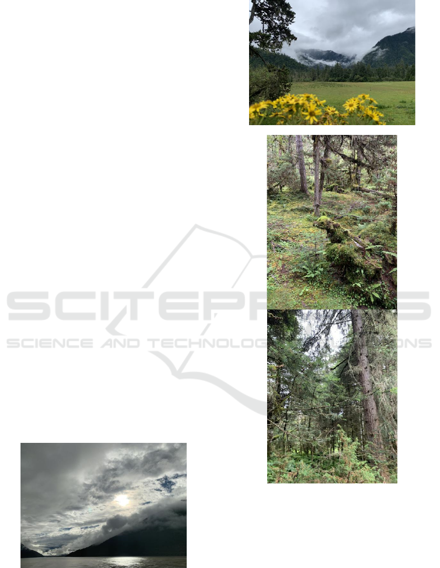
region. Figure 1. shows series of photos taken in the
study area.
Nyingchi is home to a variety of minority ethnic
groups. Having a population of around 2.3 million
until 2016, its ethnic race mainly consists of Tibetans,
Menba, Luoba, Nu, Dulong, Naxi, Bai, Lisu, and Yi.
This unique ethnic combination has shaped both the
culture and production activities in Nyingchi region,
as can be seen in our next section.
a) Yarlung Tsangpo River Valley
b) Entrance of Nyingchi village
c, d) Inside the primordial forest of Nyingchi region, near
Nyingchi village
Figure 1. Photos of Nyingchi region.
3 PRELIMINARY RESULTS
Here we show preliminary results obtained from
some of the interviews. We observe drastically
different living styles in Nyingchi from the northern
CoEEE 2021 - International Joint Conference on Energy and Environmental Engineering
96
traditional pastoral region of Tibet, where a nomadic
lifestyle is led in the arduous conditions of the
highland. Nyingchi region is well ecologically
endowed, leaving its inhabitants with rich living
materials. The production patterns in Nyingchi are
similar to a self-sufficient farming economy, with a
focus on the cultivation of arable land, along with
extensive use of natural endowments in the
mountains and rivers, such as mining valuable
precious medical materials for trade. The fertile land
and warm climate as well as the rich forest and biotic
resources allow the local inhabitants relative well-off
living conditions, comparably better than a typical
inland Chinese farmer, due to the agreeable climatic
conditions for farming and extra tourism dividends.
The food abundance is shown to be extremely high,
with suitable conditions for raising a variety of
livestock (cow, yak, pig, chicken, duck, sheep, goat,
etc.), fertile black soil for growing crops and
vegetables, and rich biotic resource in the nearby
forest for spice, seasoning, fungus, medicines, as
well as other wild food sources. This is in great
contrast to the northern pastoral region of Tibet
where only yak and goats are the available source of
food. Housing is provided by the government in the
region, with an architectural appearance similar to
traditional Chinese cottages with Tibetan decorations.
The major energy source in the region consists of
firewood collected from the forest, hydropower from
traditional hydropower stations, and modern power
grids. Cow and yak dung are also collected for
burning. Primary and secondary education is
provided by the local government free of charge,
living expenses such as meals in canteens are
provided to students in the form of subsidies.
Additionally, we find phone service generally take
up a significant proportion of the expenses in the area,
sometimes accounting for around 15% of the total
expenses.
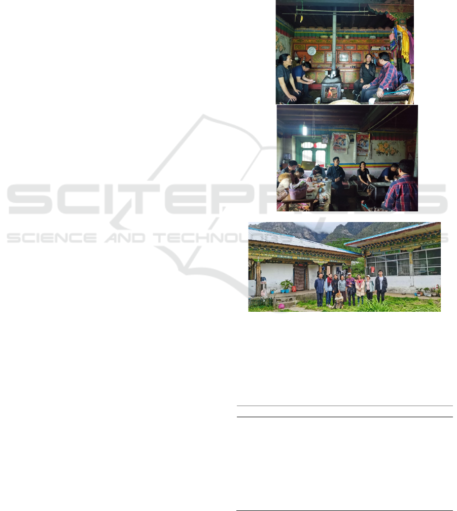
The following content provides the income, asset,
and expenditure list for an interviewed family of
three, including husband, wife, and son (two married
daughters not taken into account)(table 1.). Salary
income from part-time jobs as truck driver and
cement worker is the main source of income for the
family, taking up more than half of the total income
(approximately 53.7%). Income from the tourism
industry also takes up a significant share of the total
income (approximately 43.0%), including selling
food to tourists (32.2%) and dividends from tourist
attraction ticket fees (10.7%). Pastureland subsidies
are also provided to families, depending on the acres
of pastureland that is contracted to the family. The
conventional major expenses of a family such as
housing and food expenses are almost null, with the
former covered by the government and the latter self-
sufficient (from self-owned cultivated-land and
livestock). The major expenses for the interviewed
family include education, phone service, and clothing,
each taking up 74.9%, 14.9%, and 6.2% of the total
expenses, respectively. The physical asset of the
family includes housing provided by the government,
arable land in the back yard of the house, and
livestock (15 cows, 10 pigs, 60 chickens).
a, b) Interview scenes taken inside the family’s house
c) Photo of interviewee and research group in front of the
family house
Figure 2. Photos of a selected interviewed family in
Nyingchi.
Table 1. Income, asset, and expenditure list for an
interviewed family of 3.
Income
Ticket from tourism 10000RMB/year
Pastureland subsidy 3000RMB/year
Selling potatoes, fish, tea
to tourists
30000RMB/year
Income from part-time
job (husband)
50000RMB/year (truck
driver and cement worker)
Southern Tibet Human Activities: Ecological Footprint Analysis of Nyingchi Region
97

Assets
House approximately 100 sq m
(provided by the
government)
Arable land approximately 500 sq m
Cows 15/yea
r
Pi
g
s 10/
y
ea
r
Chicken 60/yea
r
Expenditure
Housin
g
0
Food 0 (self-sufficient)
Electricity bill 556RMB/year
Clothes 2000RMB/year
College education
(enrollment fee)
700RMB/year
College education (living
ex
p
enses)
24000RMB/year
Phone service 4800RMB/year
4 PRODUCTION INTENSITIES
OF THE REGION
We plan on obtaining production intensity of arable
land, pastureland, water use, energy use, and carbon
emissions in the Tibetan region of 42 economic
sectors. After obtaining a detailed inventory list of
emissions water use, land use, and energy use in the
region, a systematic analysis of the series of
footprints in the region can be calculated. However,
current production intensity calculated from official
Tibetan statistic input-output data may suffer from
sectoral and regional aggregation, which point to the
need for more detailed fieldwork analysis of
production efficiencies in local regions.
5 DISCUSSIONS AND
CONCLUSIONS
Preliminary interviews and fieldwork of this study
have shown that the ecological footprints are
considerably small compared with inland regions.
The investigation of the village has shown that the
production patterns of the Nyingchi region is similar
to a combination of subsistence forest economy and
small-scale farm economy, with a large proportion of
the daily necessities harvested in a self-sufficient
manner. With the current data and fieldwork setup,
this study plans to make further progressions in the
following area:
First, face-to-face semi-structured interviews with
the villagers in the Nyingchi area need to be carried
out to collect more data on the living expenditures and
incomes of families. The field study plans to apply the
snowball sampling method that aims to survey at least
50 more participants to acquire needed data to be
incorporated in the full set of evaluation models that
has been developed.
Continue field monitoring of greenhouse gas
emissions in already established points in the
Nyingchi Region, and deploy more sampling points
of water use, land use, and energy use in the region to
build a comprehensive emissions inventory of the
region’s GHG emissions and other resource use.
A full set of evaluation systems that consist of
standard procedures to analyze the multi-scale living
footprints of residents in Tibet will then be applied.
REFERENCES
Chen, G. Q., Guo, S., Shao, L., Li, J. S., & Chen, Z. M.
(2013). Three-scale input–output modeling for urban
economy: Carbon emission by Beijing 2007.
Communications in Nonlinear Science & Numerical
Simulation, 18(9), 2493–2506.
Chen, G. Q., Wu, X. D., Guo, J., Meng, J., & Li, C. (2019).
Global overview for energy use of the world economy:
Household-consumption-based accounting based on
the world input-output database (WIOD). Energy
Economics, 81, 835–847.
https://doi.org/10.1016/j.eneco.2019.05.019
Duan, A., & Wu, G. (2006). Change of cloud amount and
the climate warming on the Tibetan Plateau.
Geophysical Research Letters, 33(22).
https://doi.org/10.1029/2006gl027946
Fan, J., XU, Y., WANG, C., NIU, Y., CHEN, D., & SUN, W.
(2015). The effects of human activities on the
ecological environment of Tibet over the past half
century. Chinese Science Bulletin, 60(32), 3057–3066.
Gao, Q., Wan, Y., Li, Y., Guo, Y., Ganjurjav, Qin, X.,
Jiangcun, W., & Wang, B. (2013). Effects of topography
and human activity on the net primary productivity
(NPP) of alpine grassland in northern Tibet from 1981
to 2004. International Journal of Remote Sensing, 34(6),
2057–2069.
Jiang, W., Lü, Y., Liu, Y., & Gao, W. (2020). Ecosystem
service value of the Qinghai-Tibet Plateau significantly
increased during 25 years. Ecosystem Services, 44,
101146.
Sheehy, D. P., Miller, D., & Johnson, D. A. (2006).
Transformation of traditional pastoral livestock systems
on the Tibetan steppe. 17, 10.
Shen, M., Piao, S., Jeong, S.-J., Zhou, L., Zeng, Z., Ciais,
P., Chen, D., Huang, M., Jin, C.-S., Li, L. Z. X., Li, Y.,
Myneni, R. B., Yang, K., Zhang, G., Zhang, Y., & Yao,
T. (2015). Evaporative cooling over the Tibetan Plateau
CoEEE 2021 - International Joint Conference on Energy and Environmental Engineering
98

induced by vegetation growth. Proceedings of the
National Academy of Sciences, 112(30), 9299–9304.
https://doi.org/10.1073/pnas.1504418112
Wu, X., Li, C., Shao, L., Meng, J., Zhang, L., & Chen, G.
(2021). Is solar power renewable and carbon-neutral:
Evidence from a pilot solar tower plant in China under
a systems view. Renewable and Sustainable Energy
Reviews, 138, 110655.
https://doi.org/10.1016/j.rser.2020.110655
Zhao, H., Liu, S., Dong, S., Su, X., Wang, X., Wu, X., Wu,
L., & Zhang, X. (2015). Analysis of vegetation change
associated with human disturbance using MODIS data
on the rangelands of the Qinghai-Tibet Plateau. The
Rangeland Journal, 37(1), 77–87.
Southern Tibet Human Activities: Ecological Footprint Analysis of Nyingchi Region
99
