
Application of Google Map API for Web Tourism Destination
Information Service in Southeast Minahasa Regency
Olga Melo
1
,Oktavianus Lintong
2
, Anthon Kimbal
1
, Harson Kapoh
1
, Ivone Putong
3
and Pearl Wenas
4
1
Department of Information Technology, State Polytechnic of Manado, Buha, Manado, Indonesia
2
Department of Tourism, State Polytechnic of Manado, Buha, Manado, Indonesia
3
Department of Accounting, State Polytechnic of Manado, Buha, Manado, Indonesia
4
Department of Administration Business, State Polytechnic of Manado, Buha, Manado, Indonesia
ivonnehelen@yahoo.com, wenaspearl@gmail.com
Keywords: Web, Tourist Attraction, Google Map API.
Abstract: North Sulawesi Province, especially Southeast Minahasa Regency, has many tourist attractions that can be
visited by local and foreign tourists, but not all tourist attractions are known by tourists because of the lack of
information on the introduction of tourist attractions. The rapid development of information technology can
make the availability of information systems better about tourist objects, therefore the provision of
information service applications for tourist destinations in Southeast Minahasa Regency in the form of a Web
needs to be developed. With the Web, it can improve the ease of access to information for tourists and the
general public. This application is designed using a web-based programming concept. The research
methodology used to build this application is the descriptive analysis method. The system development
method used in this research is the waterfall paradigm process model by implementing analysis and design
using use case diagrams, activity diagrams with the process of displaying maps on the web applying the
Google Maps API with the support of JQuery technology to display photos and images as needed so that users
can see the map distribution of existing tourist objects/tourist destinations along with information about each
tourist attraction.
1 INTRODUCTION
Today, destinations and tourism industry are given
mandate to develop world-class, competitive,
sustainable, and able to encourage regional
development. One of the goals of the 2015-2019
Tourism Industry and Destinations Development
Program is to increase new tourist destinations,
especially new nature, by finding pilot tourist
destinations so as to increase the number of tourist
destinations (Muchson, 2021).
North Sulawesi Province is one of the provinces
located in the northern tip of Sulawesi Island with the
capital city located in Manado City, consisting of 11
regencies and 4 cities. North Sulawesi has many
tourist attractions that can be visited by local tourists
as well as foreign tourists, but not all tourist
attractions are known by the tourists because of the
lack of an introduction information on the attraction
places.
Southeast Minahasa Regency which is part of
North Sulawesi province has many potential tourism
objects. The use of technology, especially
information technology, will greatly support the
development of tourism (Kawengian et al., 2018).
The increasing use of today's technology among the
people can be utilized as an opportunity to improve
information services about tourism in Southeast
Minahasa district.
The application of tourist destination information
services in Southeast Minahasa District can be used
as an alternative guide to get information about the
place of attraction in southeast Minahasa Regency.
With this application, it can increase the ease of
access to public information. This app will use
Google Maps as a support facility that will display the
map of the place of attraction.
Based on the background, the application of
tourist destination information services in Southeast
Minahasa District can contribute to the tourism
sector, improve the introduction of information on the
1496
Melo, O., Lintong, O., Kimbal, A., Kapoh, H., Putong, I. and Wenas, P.
Application of Google Map API for Web Tourism Destination Information Service in Southeast Minahasa Regency.
DOI: 10.5220/0010967900003260
In Proceedings of the 4th International Conference on Applied Science and Technology on Engineering Science (iCAST-ES 2021), pages 1496-1500
ISBN: 978-989-758-615-6; ISSN: 2975-8246
Copyright
c
2023 by SCITEPRESS – Science and Technology Publications, Lda. Under CC license (CC BY-NC-ND 4.0)
area of southeast Minahasa Regency and can facilitate
local and foreign tourists to get information about the
place of attraction that will be the regency of
Southeast Minahasa.
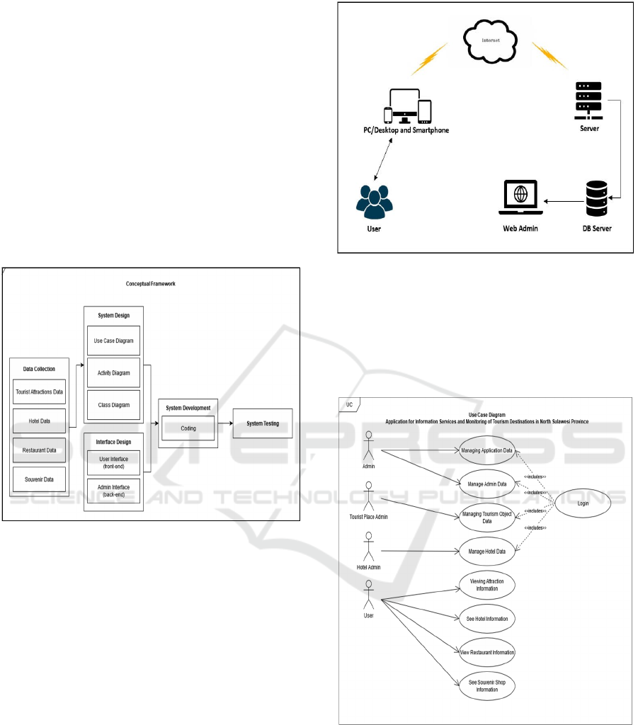
2 CONCEPTUAL FRAMEWORK
2.1 Conceptual Framework
Conceptual Framework is a form of thought
framework that can be used as an approach in solving
problems. Usually this research Framework uses a
scientific approach and demonstrates relationships
between variables in the analysis process.
Figure 1: Conceptual Framework.
2.2 System Architecture
The planning of Information services and Monitoring
tourism destinations in Southeast Minahasa District
was built to facilitate the users in this case tourists, in
search of tourist information, especially the stub
objects in southeast Minahasa Regency.
Figure 2. Is architecture system consisting of three
main parts, namely client, application server and
database server.
Figure 2: Architectural Information Services tourism
destination.
3 ANALYSIS AND DESIGN
3.1 Use Case Diagram
Figure 3: Use Case Diagram.
Here is the use case diagram of the Information
Service application and Monitoring tourism
destination in Southeast Minahasa district.
Application of Google Map API for Web Tourism Destination Information Service in Southeast Minahasa Regency
1497
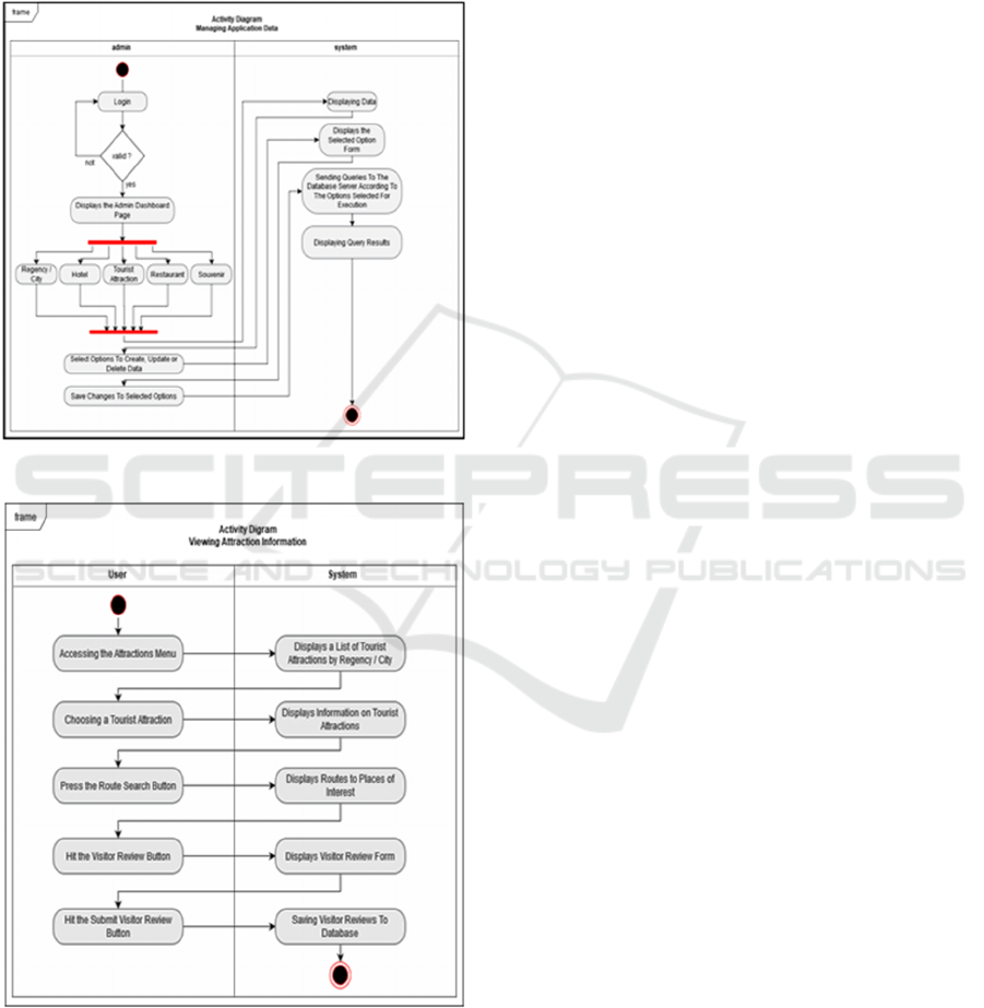
3.2 Activity Diagram
Fig. 4 is a design of the web that is divided into two
parts, namely admin activity and system activity.
Admin activities do create, update and delete data.
System activity will process create, update and delete
and display on the Web.
Figure 4: Activity Diagram.
Figure 5: Activity Diagram of the attraction.
Fig 5. Is a design activity of the attraction consisting
of user activity and system activity. User can see and
choose the attraction place. The system can display
the attraction data and its information.
4 IMPLEMENTATION
TECHNOLOGIES
This system of tourism Information is designed,
implementing several technologies that combine to
get maximum results. This designed tourism
information system implements several combined
technologies to get maximum results.
4.1 Google Map API
Google's company provides Google MAPS APIs as a
programming Interface . Using the Google Maps
APIs facility can make it easy for developers to
realize The program it wants (Zhi-xue, 2013). This is
because the APIs are provided in the JavaScript
language so that the developer of the program can
easily integrate the Map service with the project
being developed (Soelistijadi, 2016). Google Map
provides a library of APIs, so developers can easily
create a specific location point. Reference (Pradipta
and Ayu, 2016) Google with the Google Maps APIs
provides 4 types of map model options, namely,
1. ROADMAP, to display the usual 2- dimensional
map
2. Satellite, to display the satellites photo
3. TERRAIN, to show the physical reliefs of the
Earth's surface and show how high a location is,
for example will show mountains and rivers
4. HYBRID, will show the photo of the satellite
that is pictured also what appears on THE
ROADMAP (Street and city name).
The implementation of Google MAP APIs on this
tourism Web is
1. Creating Maps:
This tourism Web needs a map for the need to
display location so as to facilitate the user to
find, see the desired tourist location. The
required JavaScript code is as follows:
Map creation
var peta = new
google.maps.Map(document.getElem
entById('googleMap'),
mapOptions);
2. Initialization:
Variables for storing location information
var infoWindow = new
google.maps.InfoWindow;
Variables contain map type properties
var
m
apOptions ={mapTypeId:
google.maps.MapTypeId.ROADMAP
iCAST-ES 2021 - International Conference on Applied Science and Technology on Engineering Science
1498
3. Storing coordinate borders:
Var bounds = new
google.maps.LatLngBounds();
4. Retrieving data from a MySQL database:
<?php
include "config/conn.php";
?>
<?php
$query = mysqli_query($conn,"SELECT
* FROM objek_wisata ORDER BY nama
ASC");
while ($row =
mysqli_fetch_array($query)) {
$nama = $row ["name"];
$lat = $row["latitude"]; $long =
$row["longitude"];
echo "addMarker('$lat', '$long',
'$nama');\n";
Making marker:
Marker making process
function addMarker(lat, lng, info){
var lokasi = new
google.maps.LatLng(lat, lng);
bounds.extend(lokasi);var marker = new
google.maps.Marker({
map: peta,
Position: Location
});
peta.fitBounds(bounds);
bindInfoWindow(marker, peta,
infoWindow, info);
Marker Displays information:
function bindInfoWindow(marker, peta,
infoWindow, html){
google.maps.event.addListener(marker,
'click', function() {
infoWindow.setContent(html);
infoWindow.open(peta, marker);
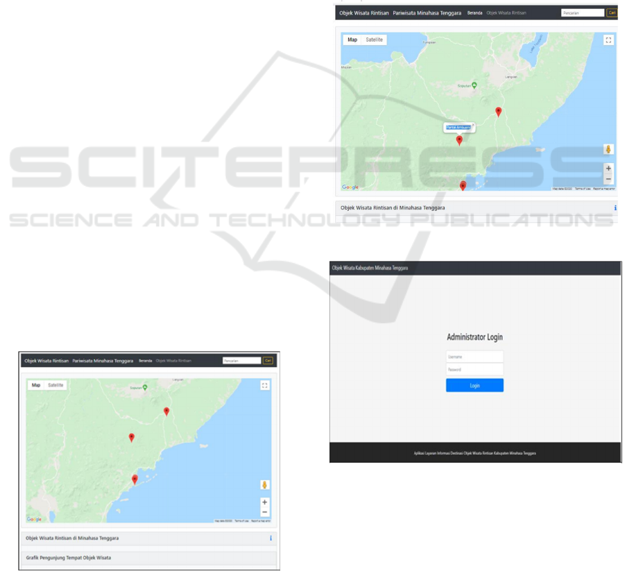
Figure 6: Screenshot of map mark.
Fig. 6 is a frontend display which is part of this
website which aims to provide information to the user
about pilot tourism locations in the form of a sign on
the map so that the user can ensure that the tourist spot
is located. Hopefully this will later help find the pilot
tourism locations.
Fig. 7 is a display of the web frontend which later
can be used by users to find out more detailed
information or explanation of pilot tourism locations
in Southeast Minahasa district, namely in the form of
place names and other information from pilot tourism
objects.
Information on fig. 6 and fig. 7 can be displayed
on the frontend due to input activity through the
backend by the admin which is read by the program,
processed and displayed.
Figure 7: Screenshot of detailed mark information.
Figure 8: Screenshot of administrator login.
Fig 8. is the login page which is part of the web
on the backend which can be used by the admin to
manage the web so that the information needs on the
homepage are realized.
Application of Google Map API for Web Tourism Destination Information Service in Southeast Minahasa Regency
1499

4.2 Technology of JQuery
JQuery is including the Framework JavaScript which
can be used Cross browser which has multiple
components of pages and a lightweight javascript
library. Using JQuery helps users to freely handle
HTML documents with the application of animation
effects. Additionally, this framework provides an
AJAX function That can interact directly for the
operation of webpages. Using the JQuery Framework
technology, page logic is separated from page
content, making it easier to work with HTML code
(Wu et al., 2013). JQuery technology is very suitable
to be applied to this tourism Web. Because many
display photos or images that need to be sized to the
right scale automatically.
5 CONCLUSION
Based on the need for tourist destination information
that is easily accessible to the public, a Web service
that is integrated with a map is required that
references the points of location of tourist attractions
along with the explanations needed by users. The
application of the Google Maps API on the Tourism
Web is very helpful in developing a Web that displays
maps and the features needed.
ACKNOWLEDGEMENTS
Thanks to Manado State Polytechnic who has given
the opportunity to do this research.
REFERENCES
Ardhiyani, R. P., & Mulyono, H. (2018). Analisis Dan
Perancangan Sistem Informasi Pariwisata Berbasis
Web Sebagai Media Promosi Pada Kabupaten Tebo.
Jurnal Manajemen Sistem Informasi, 3(1), 952-972.
Chrismartin, P. Y., Aniroh, K., & Supriadi, B. The
Preliminary Study of Aron: an Authentic Food of
Bromo Viewed from Halal Principles and Food
Tourism. Contemporary issues on Halal Development
in Indonesia, 192.
Kawengian, F., Lengkong, F. D., & POMBENGI, J. D.
(2018). Perencanaan Pembangunan Sektor Pariwisata
Di Kabupaten Minahasa Tenggara. JURNAL
ADMINISTRASI PUBLIK, 4(51).
Muchson, M. (2021). Exploring the Creative Economic
Potential of Kediri Targeting to Become Creative City
on UNESCO Standard and the Indonesia Ministry of
Creative Economy (KEMENPAREKRAF). Journal of
Economics and Sustainable Development, 12(16), 47-56.
Pradipta, G. A., & Ayu, P. D. W. (2016). Pembangunan
Aplikasi Pemandu Wisata di Bali Menggunakan
Google Maps Api Berbasis Web. Prosiding SNATIF,
209-216.
Soelistijadi, R. (2016). Sistem Informasi Pariwisata
Berbasis Web: Studi Kasus Fasilitas Penginapan Di
Wilayah Propinsi Yogyakarta.
Wu, Y., Liang, Z., & Liu, L. (2013, June). Design and
implementation of tourism information system based
on Google Maps API. In 2013 21st international
conference on geoinformatics (pp. 1-4). IEEE.
Zhi-xue, L. I. A. N. G. (2013). Design and Implementation
of Tourism Information System Based on Google Maps
API. Computer and Modernization, 1(7), 208.
iCAST-ES 2021 - International Conference on Applied Science and Technology on Engineering Science
1500
