
User Requirement and Use Case Diagram for Traveler Tracking
Application in Tourist Destination
I Ketut Gede Sudiartha, I Nyoman Eddy Indrayana, I Wayan Suasnawa, I Made Ari Dwi Suta Atmaja,
Komang Ayu Triana Indah and Putu Wijaya Sunu
Department of Electrical Engineering Politeknik Negeri Bali, Badung-Bali, Indonesia
wijayasunu@pnb.ac.id
Keywords: Traveler Tracking System, Object Tracking Application, GPS Tracking System.
Abstract: Traveller Tracking Application is useful for controlling the movement of tourists. Besides that, it is also useful
to look back at the history of tourist trips in tourist attractions. The application built is intended for tourists
who vacation in groups. The history of tourist movements can be used to detect tourist attractions that are
frequently visited. Also, you can see the position or path of tourists again if an accident occurs. This article
discusses the stages of developing a mobile tourist tracking application that starts from the requirements
system, analysis, and until the system design stage. The data of tourist movements at tourist attractions will
be recorded in real-time and stored in the cloud. Position data obtained from the traveler's GPS smartphone is
stored in the firebase realtime database. The system design includes an architecture system, use case diagram,
and a flowchart for draw trajectory on the map. The results of this research stage are some data requirements,
namely real-time position data, the history of the track that tour leaders and tourists have traveled, personal
data of tour leaders, and travelers. Actors involved are guides as tour leaders, members of tourist groups, and
tour travel management. Tour leaders and tour group members carry GPS-equipped smartphones, while
management uses desktops to track tour leader track. This aims to ascertain whether the tour leader trajectory
is following that determined by the management of the tour travel company. Management can also see the
Interest of a certain nationality of a tourist attraction.
1 INTRODUCTION
Tracking systems are very popular these days.
Tracking systems are widely applied in the fields of
transportation, logistics, security systems, inventory,
and other fields, including tourism.
Tracking systems require the latitude and
longitude coordinates of an object on earth. These
coordinates are obtained from Satellite GPS. To
locate and track two-dimensional (longitude and
latitude) movement, the receiver requires a signal
from at least three satellites. However, several factors
affect its accuracy such as an environment with tall
buildings or dense trees which can obstruct the
satellite signal reception.
The tourism sector uses latitude and longitude
coordinates for several purposes, including
monitoring the position in real-time and looking back
at the traveler's trajectory. Sometimes Tour travel
management needs certainty, whether the employees
are working according to the route rules issued by the
company, or violating the rules of the route that has
been set. Group travelers usually choose tour
packages offered by travel companies. Each group is
accompanied by a tour leader to lead the tour. Lost
contacts often occur when a traveler leaves the group
too far. To make it easier to monitor and review the
position of the tour group members, the tour leader
can be equipped with a car application. This mobile
application uses GPS data as the main data. The
position data of the traveler and tour leader is
combined with the google map to get a more
interactive visualization.
2 RELATED WORKS
Savchuk said that GPS technology plays an important
role in building information systems for the tourism
sector. Data from GPS is the main data to build Good
quality mobile travel information. Mobile travel
1376
Sudiartha, I., Indrayana, I., Suasnawa, I., Atmaja, I., Indah, K. and Sunu, P.
User Requirement and Use Case Diagram for Traveler Tracking Application in Tourist Destination.
DOI: 10.5220/0010965700003260
In Proceedings of the 4th International Conference on Applied Science and Technology on Engineering Science (iCAST-ES 2021), pages 1376-1380
ISBN: 978-989-758-615-6; ISSN: 2975-8246
Copyright
c
2023 by SCITEPRESS – Science and Technology Publications, Lda. Under CC license (CC BY-NC-ND 4.0)

applications such as navigators, route planners, travel
computer guides, augmented reality systems.
Beaco Hallo[9] researched by combining GPS
Visitor Tracking (GVT) and Recreational Suitability
Mapping (RSM) to show that social data can be
incorporated into planning at various scales. The
result of combining GVT and RSM contributes to
current recreational patterns and areas suitable for
specific recreational activities. This combination is
especially important because the areas studied have a
small area, high spatial demands, and the potential for
conflict between user groups.
Karpilo researched collecting route GPS data
from tourists visiting the Keskuspuisto tourist area
(Central Park), Helsinki, Finland. This data is used to
determine the movement patterns of tourists at tourist
attractions. This study collects useful, low-cost, up-
to-date information that provides city planners and
managers with a better input on the spatial
distribution and intensity of tourist movements.
Several other studies that use GPS for human
tracking are research conducted by Rein Ahas, Harari,
and Tatjana. They use tourist position data to detect
tourist habits when visiting tourist objects. In this
case, the detected tourist habits are limited to the
tourists' habits in determining which areas are their
favorite places to visit.
3 METHODOLOGY
3.1 Unified Software Development
Process (USDP)
USDP is a methodology regarding software
development, especially object-oriented software.
USDP is a continuous system development process,
where each part is carried out iteratively. USDP
adopts an iterative approach with 4 main phasesso
that it does not follow the traditional software
development life cycle (waterfall model). Every
phase of activity which is important in system
development is emphasized. The Rational Team is the
team that first introduced this methodology. Various
applications can be created with a framework due to
the concept of coding reuse, where the need for
similar applications can use the same coding. In one
phase there can be more than one iteration. The
characteristics of the USDP are as follows:
• Use-case Driven, The resulting software should
serve its users and match the needs and
expectations of the users.
• Architecture Centric/ System architecture, where
user needs and expectations are reflected and seen
in use case definitions, such as the computer
architecture used, database management systems
(DBMS), operating systems, communication
protocols, and non-functional requirements
(performance, reliability).
• Iterative and Incremental, commercial software
development usually continues for several
months or even years, this makes software
development project work done iteratively so
that in the end the resulting large integrated
software is formed incrementally.
The stages in USDP are the Inception,
Elaboration, Construction, and Transition stages. The
Inception phase is the software development phase to
interact with application users. The Inception phase is
used to identify the needs of the application being
built. Equalizing perceptions about system input and
output desired from users, between software
development and application users is done in this
phase. In the Elaboration phase, system design is
carried out and refines the concepts that have been
identified in the Inception phase. The design stage can
use an object-based system approach, namely UML.
Construction phase, where the programmer phase
translates the design into programming language
coding. Transition Phase, at this stage software
testing, is carried out on the user side. Program codes
that are still wrong, are corrected to suit user needs.
4 DESIGN SYSTEM
4.1 Raw Data Requirement
This tourist tracking application involves several
actors who are involved in it. Each actor has a role in
this system. From the survey conducted, this
application involved 3 main actors. The first actor is
a tourist as a member of a tour group, the second is a
tour leader, and the third is the management of a tour
and travel company. Travelers traveling in groups at
tourist attractions have passport number, traveler
name, traveler address, nationality. The tour leader
has tour leader identification, tour leader name, tour
leader email, handphone number, and tour leader
address. Tour travel management has tour travel
identification, name, address, and handphone
number. We need data on the position of each object
being monitored to visualize the path on the map. The
position object has attributes for id, date position,
longitude, latitude, user id, and timestamp. The
User Requirement and Use Case Diagram for Traveler Tracking Application in Tourist Destination
1377
timestamp is needed to sort object position data based
on the sequence of events.
4.2 Architecture System
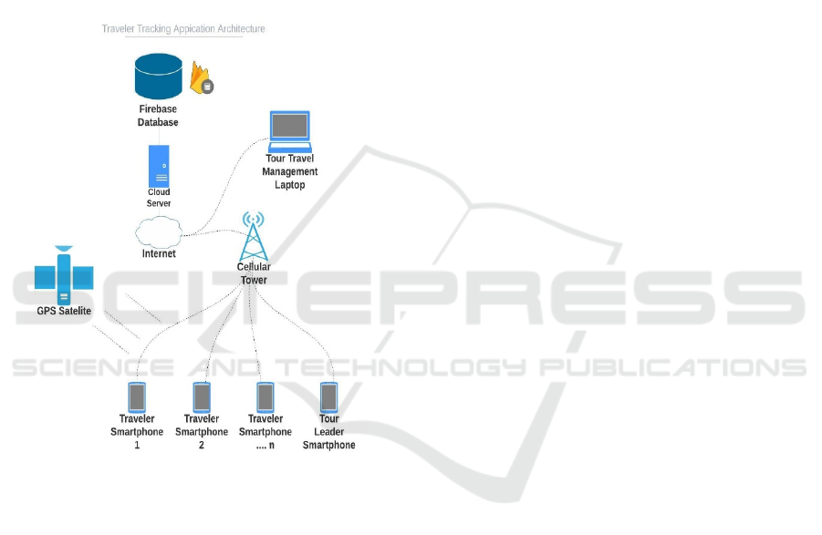
In fig 1, The GPS satellite will provide position data
from each traveler which is given to the GPS receiver
device of the traveler and tour leader smartphone.
Position data in the form of latitude and longitude
from traveler and tour leader will be sent to the
cellular network. From this cellular network, go to the
internet network to the web server address that has
been specified in the application.
Figure 1: Traveler Tracking Application Architecture.
The Web Server will store application data to the Firebase
database. Both tour leaders and tour travel management are
used data together that have been stored in firebase. Tour
leaders use this data to determine the position of group
members making it easier to monitor the movements of
their group members. Likewise, tour travel management
uses data stored in Firebase to display the trajectories of the
tour leader and group members from the laptop. The
application is used by web-based tour travel management.
4.3 Use Case Diagram System
A use case describes an interaction between the user
(actor) and the system. Use Case diagrams are a
sequence of interrelated interactions between systems
and actors. Use cases are executed by describing the
type of interaction between the user of a program
(system) and the system itself. Use case diagrams are
diagrams that can describe the facilities in the system.
This application is designed to be 2 base systems,
namely mobile base and web base. Tracking Traveler
This application was designed with three actors,
namely traveler, tour leader, and tour travel
management. Use case designed on mobile base,
include sent position, see own position on map, see
group member, tour member registration, see all
member positions on the map, and traveler trajectory
tracking. On the web base, case maintenance group
members are designed, web base all members on
google map, web base traveler trajectory, tracking
and view reports.
Use case sent positions are carried out by traveler
actors and tour leaders. Traveler and tour leader send
their position via android mobile phones. Position
data in the form of latitude and longitude are obtained
from GPS satellites. The latitudes and longitudes of
traveler and tour leaders are stored in the firebase
database. Use case see own position on map can be
done by traveler actor and tour leader. This case
allows travelers and tour leaders to see their
respective positions on the google map that is
displayed on the screen of the android mobile phone.
Case see group members is performed by tour leader
actors. The tour leader actor can see all the names of
his tour members on a list. This list contains the
traveler's name, gender, and contact number. Case
tour member registration, this case functions to
register the names of members who are participating
in the tour group in the tourist destination. The tour
leader actor can resist the name of the member, the
address of the member, and the cellphone number of
the traveler into the mobile-based system. Case see all
position members can be done by the tour leader. This
case allows the tour leader to see all the positions of
his tour group members in google map. The position
of each tour group member is displayed in real-time.
This position will be marked with a tag, which
changes according to the movement of the tour group
members. Case traveler trajectory tracking is used to
review the trajectory traversed by a traveler. Tour
leaders can look back at the area traveled by a traveler
on a certain date and display it on the screen of a
mobile device.
Tour travel management actors perform more
system functions in the web-based application. Case
maintenance group members permit to travel
management tours to add, change and delete member
data from the tour group. Web base case all member
position on google map, used by travel tours to see
the position of all travelers on the google map. The
position data used on the web base is the same as the
position data on the mobile base. Both are equipped
iCAST-ES 2021 - International Conference on Applied Science and Technology on Engineering Science
1378
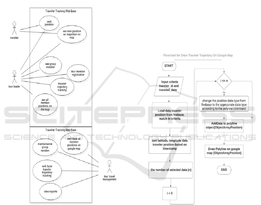
with position tags and traveler name. The web-based
case traveler trajectory tracking provides facilities for
travel management to review the trajectory of the
traveler on the web base. Case view reports are used
by tour travel management actors to view reports
needed by management. Report the most frequently
visited destination tours, Report the number of tourist
visits by nationality, and the average number of
tourist visits per month, per year handled by the travel
tour company.
Figure 2: Use Case Diagram System.
4.4 Draw Trajectory Mapping
Algorithm
The traveler trajectory is the main facility in this
application, which is visualized by the track on the
google map. Before using the google map in the
application, we must first activate the API
(Application Programmable Interface) key for our
android project. Google map key activation can be
done by going to the Google Cloud Platform Console
and creating a project. Then choose the Create
Credential menu to get the API key for our project.
Then select the Maps SDK for Android for mobile
applications and the Maps JavaScript API for web-
based applications.
The traveler trajectory is drawn by first preparing
the input data used as criteria. The criteria used are
the identity of the traveler and traveled date. This
criterion is the basis for calling data from Firebase.
Position data selected from the Firebase database,
sorted by timestamp. Position data in the form of
latitude and longitude are entered into a coordinate
data object that matches the data in the polyline
command. This coordinate object will contain as
many pairs of latitude and longitude coordinates as
the selected data. The coordinate data object is then
drawn on google with the googleMap.addPolyline()
command.
Figure 3: flowchart for Draw Traveler Trajectory on Google
Map.
5 CONCLUSIONS
The design of traveler tracking application, divide
into two base systems, they are mobile base system
and web-based system. This application requires
several actors who interact with the system, namely
travelers, tour leaders, and tour travel management.
Traveler data position and data tour leader, are the
main data for this system. Use case design involves
User Requirement and Use Case Diagram for Traveler Tracking Application in Tourist Destination
1379

several main cases, namely case sent position, case
see all position on the map, and case traveler
trajectory tracking. The application is designed to use
the google map as a visualization medium of the
position of the traveler and guide. Also to display
trajectory history from the traveler.
ACKNOWLEDGEMENTS
This research was support by the Directorate of
Research and Community Service, Director General
of Development and Research Enhancement,
Ministry of Research, Technology and Higher
Education, under the research contract: Nomor: 133/
SP2H/AMD/ LT/ DRPM/2020. SP DIPA- 042.06.
1.401516 / 2020 November 12, 2019.
REFERENCES
M. N. Hoq, M. M. K., Alam, M. J., & Mustafa. (2017).
Mobile Tracking System using Web Application and
Android Apps. Int. J. Eng. Res. Technol. (IJERT), vol.
6, no. 02, pp. 257-262.
J. C. Hallo, J. A. Beeco, C. Goetcheus, J. McGee, N. G.
McGehee, and W. C. Norman. (2012). GPS as a Method
for Assessing Spatial and Temporal Use Distributions
of Nature-Based Tourists. J. Travel Res., vol. 51, no. 5,
pp. 591–606, doi: 10.1177/0047287511431325.
I. K. G. Sudiartha, I. N. E. Indrayana, I. W. Suasnawa, and
P. I. Ciptayani. (2018). Design aAnd Implementation of
Group Tourist Monitoring Application with Realtime
Database Firebase.
I. N. E. Indrayana, P. Sutawinaya, N. M. Wirasyanti, I. K.
Swardika, and P. W. Sunu. (2020). Design of Children
Monitoring Application for Outdoor Activities Using a
Smart Watch. J. Phys. Conf. Ser., vol. 1569, no. 3, doi:
10.1088/1742-6596/1569/3/032093.
I. K. G. Sudiartha, I. N. E. Indrayana, I. W. Suasnawa, S.
A. Asri, and P. W. Sunu. (2020). Data Structure
Comparison between MySql Relational Database and
Firebase Database NoSql on Mobile Based Tourist
Tracking Application. J. Phys. Conf. Ser., vol. 1569, no.
3, doi: 10.1088/1742-6596/1569/3/032092.
A. Hardy et al. (2017). Tracking tourists’ travel with
smartphone-based GPS technology: a methodological
discussion. Inf. Technol. Tour., vol. 17, no. 3, pp. 255–
274, doi: 10.1007/s40558-017-0086-3.
P. Beldar, P. Bansode, R. Mane, and S. Gaikwad. (2014).
Traveler Guide using GPS. vol. 3, no. 2, pp. 406–409.
V. Savchuk and V. Pasichnyk. (2015). MODERN
TENDENTION IN THE USE OF GPS
TECHNOLOGY IN TOURISM INDUSTRY V .
SAVCHUK , V . Pasichnyk Lviv National Politechnic
University ; e-mail : valeriia.v.yehorova@lpnu.ua THE
ANALYSIS OF RECENT, vol. 4, no. 3, pp. 65–72.
J. A. Beeco, J. C. Hallo, and M. T. J. Brownlee. (2014).
GPS Visitor Tracking and Recreation Suitability
Mapping: Tools for understanding and managing
visitor use. Landsc. Urban Plan., vol. 127, pp. 136–145,
doi: 10.1016/j.landurbplan.2014.04.002.
S. Korpilo, T. Virtanen, and S. Lehvävirta. (2017).
Smartphone GPS tracking—Inexpensive and efficient
data collection on recreational movement. Landsc.
Urban Plan., vol. 157, pp. 608–617, doi: 10.1016/j.l
andurbplan.2016.08.005.
N. Shoval and R. Ahas. (2016). The use of tracking
technologies in tourism research: the first decade. Tour.
Geogr., vol. 18, no. 5, pp. 587–606, doi: 10.1080/
14616688.2016.1214977.
J. Raun and R. Ahas. (2016). Defining usual environment
with mobile tracking data. 14 th Glob. Forum Tour.
Stat., vol. 23, pp. 2–5.
G. M. Harari, N. D. Lane, R. Wang, B. S. Crosier, A. T.
Campbell, and S. D. Gosling. (2016). Using
Smartphones to Collect Behavioral Data in
Psychological Science: Opportunities, Practical
Considerations, and Challenges. Perspect. Psychol.
Sci., vol. 11, no. 6, pp. 838–854, doi: 10.1177/1745
691616650285.
T. Thimm and R. Seepold. (2016). Past, present and future
of tourist tracking. J. Tour. Futur., vol. 2, no. 1, pp. 43–
55, doi: 10.1108/JTF-10-2015-0045.
J. Jacobson, I. Booch, G.Rumbaugh. (1999). The Unified
Software Development Process, 1st Editio. Addison-
Wesley.
iCAST-ES 2021 - International Conference on Applied Science and Technology on Engineering Science
1380
