
Guide Application and Digitalization Map of the Mobile-based Mount
Marapi Climbing Route
Yance Sonatha, Ervan Asri, Indri Rahmayuni, Rika Idmayanti, Meri Azmi and Eka Susanti
Information Technology Department Politeknik Negeri Padang, Padang, West Sumatra Indonesia
Keywords: Android, Digital Map, Goosgle Maps, Marapi Mountain, Climbing Guide, West Sumatra Previous
Abstract: Previous mountaineering guides were obtained from various sources whose validity and effectiveness were
still in doubt, so that climbers had difficulty understanding the information provided. The route for climbing
Mount Marapi, which is located in West Sumatra, Indonesia, is usually only a painting on the wall of the post,
so climbers will have difficulty knowing and remembering the existing route. With this digitalized guide and
map application, it can provide information about Mount Marapi and a complete guide for a mountain climber,
as well as provide convenience in knowing the climbing route of Mount Marapi. This application also provides
convenience for climbers in knowing the position of climbers when climbing. So that climbers can more easily
find out the correct climbing guide and climbing routes that can be viewed at any time. This application is
made based on Android with servers using PHP and MySQL programming languages, as well as the Google
Maps feature that is used to display climbing routes.
1 INTRODUCTION
Mountain climbing and hiking activities are one of
the activities that are currently trending. This sports
activity is not only beneficial in maintaining health
and body immunity, it can also maintain mental
health by breathing fresh mountain air.
Indonesia is an archipelagic country that is
blessed with many mountains, most of which are
active volcanoes. At the beginning of 2021, there
were at least 69 active volcanoes in Indonesia
(Septiasputri, 2021).
Like other provinces in Indonesia, West Sumatra
has 29 mountains spread over 7 regencies/cities out
of 19 regencies/cities. The highest mountain is Mount
Talamau with a height of 2,913 meters, while the
lowest mountain is Mount Galanggang with a height
of 20 meters. Both mountains are located in West
Pasaman Regency (BPS, 2018).
One of the famous mountains in West Sumatra is
Marapi. Mount Marapi which is administratively
located in Agam Regency, West Sumatra about 24km
southeast of Bukittinggi. With over 60 eruptions to its
credit since the late 18th century, Marapi claims the
title of the most active volcano in Sumatra. However,
considering Marapi's name is derived from the
ancient Minangkabau dialect meaning “Mountain of
Fire” it seems likely this complex volcano has been
highly active for thousands of years. Mount Marapi is
one of the popular destinations for mountain climbing
lovers. This mountain has three climbing routes,
namely the Batu Palano, Aia Angek, and Pariangan
paths.
Mountain climbing is known to be tiring, but the
challenges involved in climbing do not deter
enthusiasts. It can be seen from the fans of this
activity who come from all walks of life. Especially
climbing Mount Marapi in West Sumatra, not only
attracts local people but also from outside the city and
even from abroad. The number of climbers on Mount
Marapi always increases from year to year, especially
during events such as the new year and the
commemoration of the Republic of Indonesia's
independence day.
A novice climber will find it difficult to know the
guide and route of a mountain correctly. Therefore,
many novice climbers must bring a guide, so that the
things they doubt can be resolved. This research aims
to produce an application that contains guides and
digital maps for the Mount Marapi climbing route.
This study uses the android mobile platform because
of the ease of access for users later.
Certainly, applied and basic research are key to
moving our understanding of IT and organizational
agility forward (Tallon, 2019). It’s all interconnected
876
Sonatha, Y., Asri, E., Rahmayuni, I., Idmayanti, R., Azmi, M. and Susanti, E.
Guide Application and Digitalization Map of the Mobile-based Mount Marapi Climbing Route.
DOI: 10.5220/0010955800003260
In Proceedings of the 4th International Conference on Applied Science and Technology on Engineering Science (iCAST-ES 2021), pages 876-881
ISBN: 978-989-758-615-6; ISSN: 2975-8246
Copyright
c
2023 by SCITEPRESS – Science and Technology Publications, Lda. Under CC license (CC BY-NC-ND 4.0)

inside the digital scene with the corresponding virtual
representation. The physical flows will be mapped on
digital platformsin a continuous manner (Alcacer,
2019).
1.1 Digital Map
Digital maps are representations of geographic
phenomena that are stored for display and analysis by
computers. Each object on a digital map is stored as a
single or set of coordinates. For example, 10 objects
that are the location of a point will be stored as a
coordinate, while an object that is a region will be
stored as a set of coordinates (Ariyanto, 2018).
Digital mapping is now ubiquitous and an
increasing amount of geodata is being created by all
sectors (Lauriault, 2019). Digital maps have at least 3
characteristics, namely scale (describes the level of
detail of objects when the map is made), geographic
references and map projection systems (determines
how objects on the earth's surface (which are not
actually flat) are moved or projected on the map
surface in the form of a flat plane).
1.2 Geo Location Technology
Android devices generally have a Geo-Location
feature that utilizes the GPS signal receiver chip
embedded in the Android device or BTS Location
Service (Kholishoh, 2021). Now several developed
countries each have different satellite constellations
for navigation systems as geo positioning service
providers including GPS (owned by the US),
GALILEO (owned by Europe), GLONASS (Russia),
BeiDou (China) (Isyanto,2013).
2 METHODS
In conducting this research, the Software
Development Life Cycle (SDLC) method was used.
SDLC is the stages carried out to build an information
system through 10 stages namely Initiation, Software
Concept Development, Planning, Requirement
Analysis, Design, Development, Integration and
Testing, Implementation, Operation and Maintenance
and Disposition (Pressman, 2010; Rastogi, 2015).
For this research 5 out of 10 SDLC stages were
used as illustrated in Figure 1 as follows:
Figure 1: Research Methodology.
a. Requirement Analysis
Requirements analysis is the process of
analyzing and developing user requirements for
web-based information systems and creating
functional requirements documents
b. Design
Design is a process that focuses on the design of
creating a web-based system with a coding
process
c. Development
Development is the stage of converting the
design into a complete information system such
as: preparing case files and procedures, system
testing, creating databases, creating program
code, and others.
d. Integration and Testing
Integration and testing are stages to find out
whether the information system made is in
accordance with the functional document
specifications or not.
e. Implementation
After analyzing user requirements, design,
coding, the finished system will be used by the
user
3 RESULT AND DISCUSSION
3.1 Requirement Analysis
Climbing to Mount Marapi is done because of a
hobby or just want to conquer the terrain of Mount
Marapi. This activity takes a lot of energy and time
from planning to climbing to the top of the mountain.
The problem when climbing is that climbing
information is hard to get, because climbers have to
ask many people or a guide to make sure the
information is correct. So that climbers will be
confused to ensure accurate information because they
find differences from various sources.
Based on the existing problem factors, the need
for the application of the Guide and Map for
Digitizing the Mount Marapi Ascent Route is as
follows:
a. This application helps users find information
about the history, location, condition, and
pictures of Mount Merapi.
b. This application helps users find climbing
guidelines such as physical preparation for
climbing, climbing equipment and supplies,
climbing regulations, first aid in accidents (first
aid) during climbing, and Mount Marapi
Requirement
Analysis
Design Development
Integration
and Testing
Implementation
Guide Application and Digitalization Map of the Mobile-based Mount Marapi Climbing Route
877
climbing routes equipped with google maps
function.
The list of application requirements
specifications can be seen in Table 1 below
Table 1: System Requirement Specifications.
SRS-ID System Requirement Specification
F-01 Users can see history, location, pictures and
conditions about Mount Marapi.
F-02 Users can see the route of the Mount Marapi
hiking trail through the Google Maps
application
F-03 Users can view climbing guides such as
mountain climbing techniques, survival to
get water, packaging of goods, and
necessary equipment
F-04 Users can find out the correct Mount Marapi
climbing regulations
F-05 Users can find out the use of existing
climbing equipment.
F-06 Admin can manage mountain data such as
editing, deleting and adding about
mountains to be displayed.
F-07 Admin can manage climbing equipment
data such as adding, editing and deleting
equipment to be displayed.
F-08 Admin can manage hiking trail data such as
editing, adding, and deleting existing trails.
NF-01 The application is easy to use
NF-02 The application has an attractive
appearance
3.2 Design
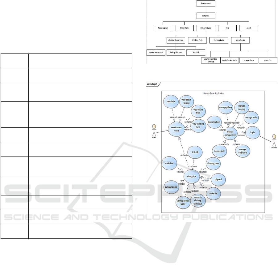
The application is designed to be accessed online via
an Android-based mobile phone. From the menu
structure design in Figure 2, there are eight main
menu options if accessing is done online, namely the
menu about Marapi, climbing guides, hiking trails,
assistance and about applications. On the climbing
guide menu there will be a list of other menus, namely
climbing preparation, climbing equipment, climbing
regulations, and other guides. The climbing
preparation menu consists of 3 choices of information
that can be seen, namely physical preparation,
packaging of goods, and climbing preparation. The
equipment menu contains information on the
equipment needed when climbing according to the
selected category. Other guide menus will contain
information about first aid, climbing techniques,
survival to get water, survival plants, and making fire.
Figure 2: Online Application Menu Structure Design.
Figure 3: Use Case Diagram.
This research also uses use case diagrams to define
the features contained in the system and also shows
the interaction between actors and the system. The
actors who play a role are users and system admins,
and the system is the Guide Application and
Digitization Map of the Mount Marapi Ascent Route.
3.3 Development
To develop a climbing guide application, several
hardware specifications are needed, including from
the Android side. When making the application, it
requires minimum hardware specifications, namely
the SDK version on Android is 16 with Android
version 4.1 (Jelly Bean) 4.5 inch screen. The
application is implemented on android with the ASUS
brand model ASUS_Z00VD android version 5.1
(Lollipop) with kernel version 3.10.72
queen@scmbuild #2 Wed Oct 21 14:11:53 CST 2015.
The maximum hardware specification is sdk version
which is 23 with android version 6.0 (marshmallows).
iCAST-ES 2021 - International Conference on Applied Science and Technology on Engineering Science
878
After creating an android application for a
climbing guide application, the application can be
accessed on an android smartphone. This climbing
guide application is recommended for use on Android
version 5.1 (Kitkat). To use this application, you
should also use an Android smartphone with a screen
size of 5.0 inches. The minimum specification to use
this application is Android version 4.1 (Jelly Bean)
and a minimum screen size of 4.0 inches.
3.4 Integration and Testing
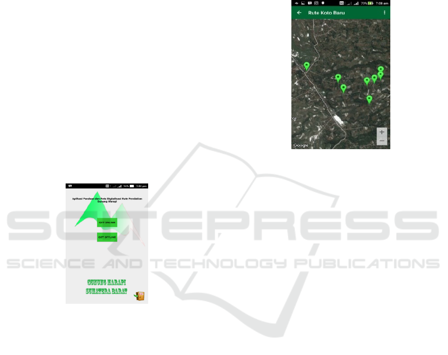
The climbing guide application is implemented on an
android smartphone. Display Android User Interface
Access is the main page display android. On this main
page the user will see 2 access menus, namely the Get
Online menu and the Get Offline menu. In each
access menu, there will be 7 menus presented in the
form of a sliding menu. The available menus are the
homepage menu, the Marapi menu, the climbing
guide menu, the hiking trail menu, the help menu, and
the application menu. The sliding menu display for
each access menu can be seen from Figure 4.
Figure 4: Application Access Menu.
At this time the application is only available in
one type of language, namely Indonesian language or
Bahasa. The online access menu provides a menu
with information that requires an internet network,
while the offline access menu provides a menu that
can be accessed without an internet network.
For online access, it has information and
submenus from 5 main menus, such as:
1. About Marapi Menu
The information about Mount Marapi will
be displayed after the user selects the menu
about Marapi.
2. Climbing Guide Menu
The guide menu which is accessed online
has a list of menu options, namely the
climbing preparation menu, climbing
equipment, climbing regulations, and other
guides.
3. Hiking Trail Menu
The hiking trail menu that is accessed online
will be displayed on Google Maps which has
set points or posts on the route on the Koto
Baru route. Each marker has an info window
that displays some of the information on the
selected point
Figure 5: Hiking Trail Menu.
The hiking trail menu on the access shown
in Figure 5 is in the form of Google Maps.
The path shown is the Koto Baru route with
a total of 27 points or posts, so there are 27
markers on the online hiking trail map.
4. Help Menu
The help menu will display information
about contacts who can be contacted in the
event of an accident requiring assistance
from the Command Post, namely the Ranger
Command Post team, as well as telephone
contacts for the Command Post who are
always on standby if they need help in the
form of information, guides, or assistance to
help climbers who have difficulty climbing.
5. About Application Menu
This menu contains an explanation of the
application in general.
3.5 Implementation
The application has been tested to determine the
climbing route of Mount Marapi, with the following
results:
a. If the user or climber selects a point on the route
and presses the route guide button, the
application will provide the correct route
direction. From Figure 6, it is known that the
marker shows the selected point, the blue dot
indicates the position of the user or climber.
Guide Application and Digitalization Map of the Mobile-based Mount Marapi Climbing Route
879
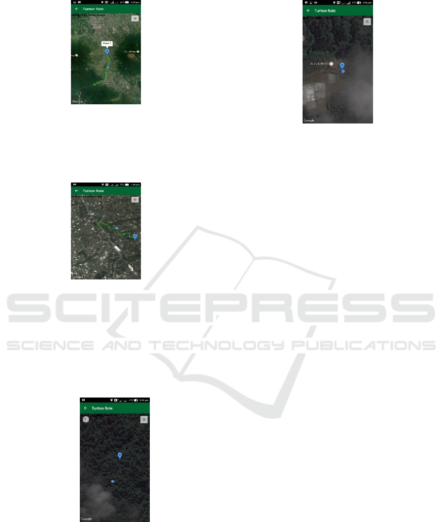
Figure 6: Guide the Route at Point One.
b. In the user's position, when making a movement
when the route guide page is running, the
position or blue point on the application will also
move according to the user's journey.
Figure 7: User Position Movement.
c. Route Guidance that shows a green line on the
road can only be done up to the Marapi post.
Meanwhile, if you have made a climb, the route
guidance will only be shown by the movement of
the climber's position or by looking at the marker
point that has been set whether it is close to the
climber's position or not (according to point
blue).
Figure 8: Route Guidance.
In Figure 8 it will be seen that the blue dot
indicating the position of the climber will move
if the climber makes a move as well. If the
climber has arrived at the marker or point it will
look like Figure 9 below.
Figure 9: Climber's Position Has Reached The Point.
At some point there are problems with the
internet connection, but the climber's position
will continue to move if the application has been
run previously when there is an internet
connection.
4 CONCLUSIONS
This research has succeeded in developing an
application guide and map for the Digitization of the
Mount Marapi Climbing Route that can be accessed
by users using an Android-based mobile phone. This
application can be accessed online or offline, but
offline, it cannot provide hiking routes from the point
where the user is located. The application is
recommended to run well on at least Android 5.1 (kit
kat). The application has many menus that can make
it easier for climbers to climb including knowing the
position of climbers from the mountain to be climbed.
To find out this climbing route can only be done
online so it needs good internet access. Further
research is needed to produce applications that can
connect between users so that it will be easier to
search for lost climbers.
REFERENCES
Alcacer, V., Cruz-Machado.,V(2019). Review: Scanning
the Industry 4.0: A Literature Review on Technologies
for Manufacturing Systems. Engineering Science and
Technology, an International Journal 22, 899-919
Ariyanto., Kurniawan,D.E.,Fatulloh,A (2018). Rancang
Bangun Aplikasi WebGIS untuk Pemetaan Kondisi
Sosial Ekonomi Kota Batam. Journal of Applied
Informatics and Computing vol 2 No 1, 27-30
Bachtiar, Hasbie Rachmat, Bambang Sudarsono dan
Sutomo Kahar (2014): Pembuatan Peta Jalur Pendakian
Gunung Ciremai, Jurnal Geodesi Undip, 3(4).
iCAST-ES 2021 - International Conference on Applied Science and Technology on Engineering Science
880

https://solokkota.bps.go.id/statictable/2018/09/26/452/nam
a-gunung-lokasi-dan-tingginya-2017.html
Kholishoh, I.,et al (2021). Geolocation Apps using A*
Algorithm for Android Based Traders. IT Journal
Research and Development (ITJRD) vol 6 no 1.
Lauriault, T.P., Taylor, D.R.F (2019). Chapter 11- The
Preservation and Archiving of Geospatial Data and
Cybercartography as a Proactive Preservation Process.
Modern Cartography Series Volume 7, 179-196
Pressman, R (2010). Software Engineering A Practitioner’s
Approach Seventh Edition, Mc Graw Hill
Rastogi,V (2015). Software Development Life Cycle
Models – Comparison, Consequences”, International
Journal of Computer Science and Information
Technologies vol 6 No 1, 168-172
Septiasputri, M.D (2021). 69 Gunung Api Aktif di
Indonesia, online access: https://rri.co.id/tanggap-
bencana/963228/69-gunung-api-aktif-di-indonesia.
Tallon, P., et al (2019). Information technology and the
search for organizational agility: A systematic review
with future research possibilities, Journal of Strategic
Information System 28, 218-237
Guide Application and Digitalization Map of the Mobile-based Mount Marapi Climbing Route
881
