
Land Boundary Map and Land Contour Map for Tourism
Accommodation Development using QGIS Software Application in
Kalisada Village, Bali
Gede Yasada and Evin Yudhi Setyono
Civil Engineering Department, Bali State of Politechnic, Bukit Jimbaran, Badung-Bali, Indonesia
Keywords:
Land Boundaries & Land Contours, GPS, Satellite Imagery, QGIS.
Abstract: Land boundary map and land contour map for large scale areas are very difficult to obtain, because these
maps in a certain area have not been made or are not owned, while the initial planning can be done without
having to wait for all these requirements to be available, such as time constraints, cost, weather and ground
measurement equipment. To quickly get a map for planning the development of tourism accommodation at
the Tukad Banyuraras estuary in Kalisada Village, Seririt District, Buleleng Regency, Bali, a map of land
boundaries and land contours was made from processing satellite image data using the Quantum Geographic
Information System (QGIS) software application and ground control point using the Global Positioning
System (GPS). Certain objects such as beaches, rivers, roads, houses, rice fields, gardens and others that were
previously in raster format in a satellite image are converted into digital format, the suitability of the name of
the element according to the object/element being plotted, drawing lines according to image appearance. The
land boundary before deducting the coastal and river borders obtained an area of 194,666.8496 m2 or
19.46668496 hectares. While the land boundary after deducting the coastal and river borders obtained an area
of 144,819.7910 m2 or 14.48197910 hectares.
1 INTRODUCTION
Indonesia is an archipelagic country consisting of a
land area of 1,922,570 km2 and a water area of
3,257,483 km2, thus requiring the government to
continuously carry out development for the benefit
of the population in Indonesia. This development
activity cannot be separated from a form of spatial
use
at the district, city, sub-district and village
levels. Of course, the use of space in the vast
territory of Indonesia must be supported by good
spatial
planning. One of the planning steps is to
prepare
geospatial information in the form of maps
of land boundaries and land contours needed for an
activity in space utilization (Rumampuk, 2013).
In the current era of development, to direct
development by utilizing regional space in an
efficient, effective, harmonious, harmonious,
balanced and sustainable manner in order to improve
community welfare and security and defense in
accordance with the mandate of the law, it is
necessary to prepare a Regional Spatial Plan. One of
the components of the Regional Spatial Plan is the
development of residential areas. As a proper
development planning effort, especially the need for
spatial data to support settlement planning, it can be
obtained quickly, cheaply but accurately, using high-
resolution satellite imagery (Parmadi, 2016).
Utilization of remotely sensed satellite images
for mapping activities is a common activity
nowadays. Spatial information presented in satellite
image maps is raster data sourced from the
continuous recording of satellite images. The stages
in mapping using the results of this sense are by
making a pattern using the sensed data which begins
with satellite processing with reference to ground
control points to limit the area to be mapped. One
example of the use of sensing technology for
activities in the field of mapping is for mapping the
coastal area at the Tukad Banyuraras estuary which
supports tourism accommodation planning activities.
Some of the advantages of mapping using remote
sensing technology include: results can be used to
map very large areas quickly, whereas manual
mapping is usually only used to map very narrow
areas, remote sensing technology is cheaper and can
600
Yasada, G. and Setyono, E.
Land Boundary Map and Land Contour Map for Tourism Accommodation Development using QGIS Software Application in Kalisada Village, Bali.
DOI: 10.5220/0010949700003260
In Proceedings of the 4th International Conference on Applied Science and Technology on Engineering Science (iCAST-ES 2021), pages 600-603
ISBN: 978-989-758-615-6; ISSN: 2975-8246
Copyright
c
2023 by SCITEPRESS – Science and Technology Publications, Lda. Under CC license (CC BY-NC-ND 4.0)
map various thematic maps. at the same time, the
manufacturing process is faster.
2 RESEARCH METHODS
The research implementation is generally carried out
in the form of information collection (secondary and
primary data collection), field surveys, problem
analysis, and inventory formulation and performance
evaluation of digital data processing.The research
work steps are outlined in the form of a research
diagram that describes the complete stages from
beginning to end sequentially to the end with a
duration of one year of research. More research
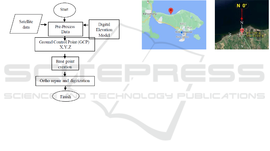
flowchart can be seen in the figure 1:
Figure 1: Research flow diagram for Land Boundary Map
and Land Contour Map for Tourism Accommodation
Development Using QGIS Software Application (Case
study at Tukad Banyuraras estuary in Kalisada Village,
Seririt District, Buleleng Regency, Bali).
Conducting field surveys, including among others:
a.
Initial survey data collection
b.
Data collection by measuring ground control
points in the field using the Global Positioning
System (GPS) tool
c.
Data calculation and satellite image processing
2.1 Measurement of Ground Control
Points
a)
Prepare the Garmin GPS 60 (Global Positioning
System) GPS device, including the completeness
of the battery to be used
b)
Set GPS coordinates to UTM (Universal
Transverse Mercator) coordinates
c)
Prepare an existing initial base map to make it
easier to find points in the field
d)
Measure coordinates in the field so that UTM
coordinates are obtained (x, y and z)
The analytical work carried out includes analysis as
a whole. The analysis carried out includes:
a.
Analysis of the tools used
b.
Measurement analysis of ground control
points
c.
Analysis of the accuracy obtained in the
digitization of the map
2.2 Research Sites
This research is located in Kalisada Village, Seririt
District, Buleleng Regency, Bali.
Figure 2: Research location in Kalisada Village, Seririt
District, Buleleng Regency, Bali.
3 RESULTS AND DISCUSSION
3.1 The Result of Ground Control
Points
As for the results of the measurement of coordinates
with a GPS device, the ground control point data is
generated as shown in table 1:
Land Boundary Map and Land Contour Map for Tourism Accommodation Development using QGIS Software Application in Kalisada
Village, Bali
601
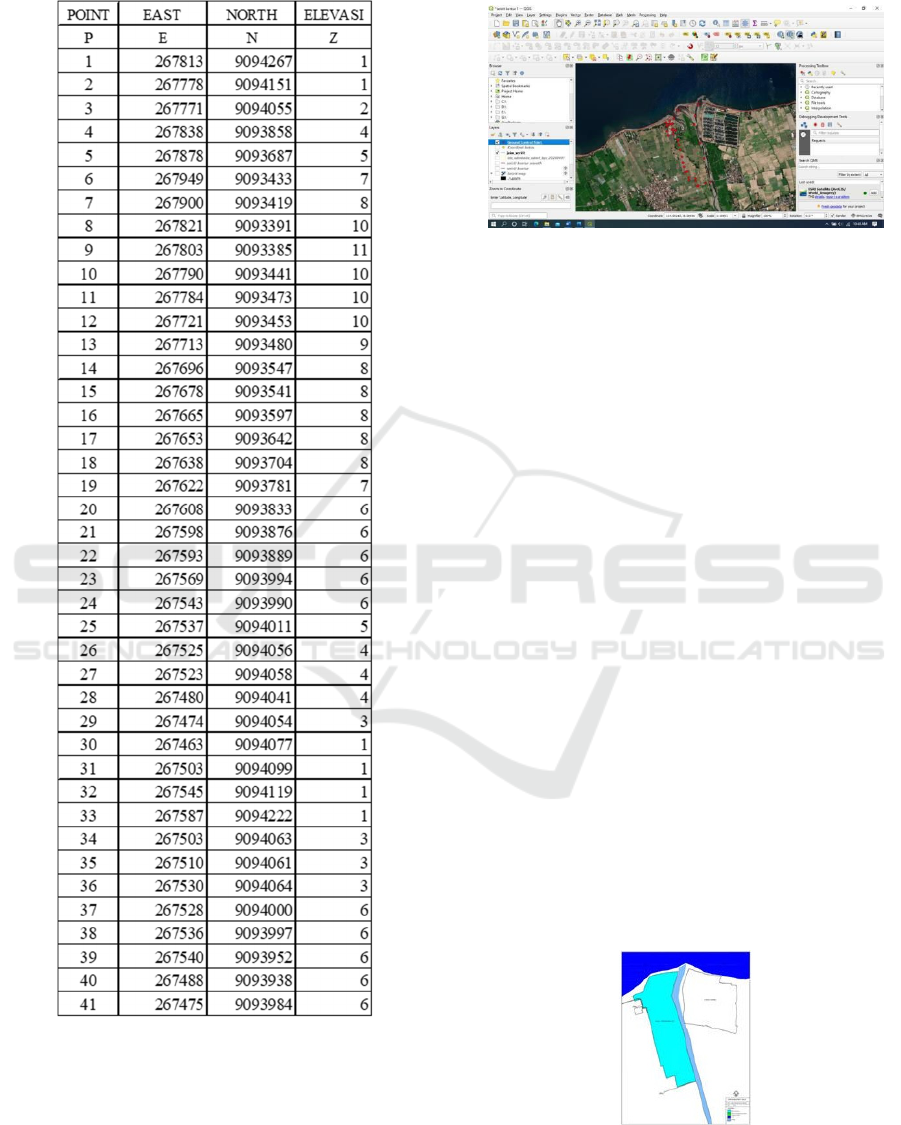
Table 1: Table of Ground Control Point (GCP) at the
Research Site.
3.2 Data Input and Map Digitization
Before importing into QGIS, it is necessary to make
arrangements first so that the coordinate data from
the GPS as the Ground Control Point can be read by
the QGIS software. Coordinate data stored in excel
is saved to a CSV (Comma delimited) file type. The
satellite image used is ESRI Satellite and the next
step is digitizing the land boundary map.
Figure 3: Data input and map digitization.
3.3 Delineation and Calculation of
Land Boundaries
Based on the Bali Provincial Regulation No. 3 of
2020 concerning Amendments to Regional
Regulation No. 16 of 2009 concerning the Bali
Provincial Spatial Plan for 2009-2029, it is regulated
regarding the existence of a coastal border for the
estuary of the Banyuraras estuary, which is 100
meters from the high highest water level and
embankment river border for rural areas which is 5
meters from the edge of the river embankment
(Peraturan Daerah Provinsi Bali No 3 Tahun 2020,
2020). Elevation of high highest water level in this
area is 0.668 m (Wicaksono, 2020) From this
regulation, it is obtained that the land limit is
allowed to be built for tourism accommodation
purposes. The boundaries and land area in question
are:
3.4 The Land Boundary before
Deducting the Coastal and River
Boundaries
The land boundary before deducting the coastal and
river boundaries is 194,666.8496 m2 or
19.46668496 hectares. The shape of the land
boundary is as shown in figure 4 :
Figure 4: Land boundaries before deducting the
boundaries of beaches and rivers.
iCAST-ES 2021 - International Conference on Applied Science and Technology on Engineering Science
602
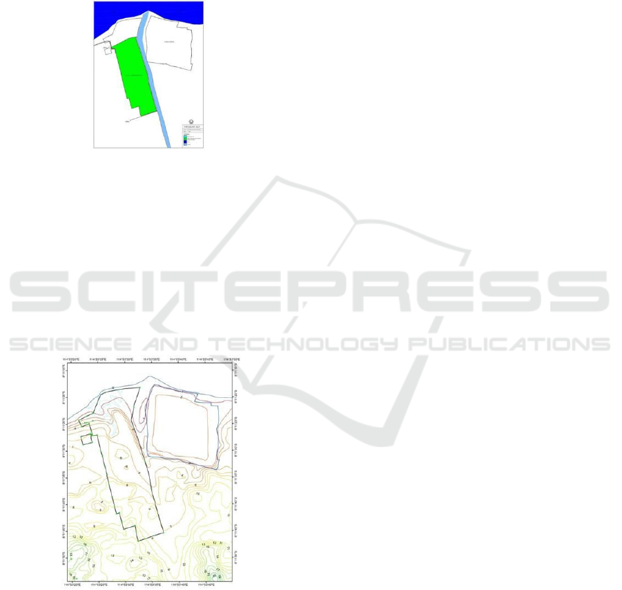
3.5 The Land Boundary after
Deducting the Coastal and River
Boundaries
The land boundary after deducting the coastal and
river boundaries is found to be 144,819.7910 m2 or
14.48197910 hectares. The shape of the land
boundary is as shown in figure 5:
Figure 5: The land boundary after deducting the coastal
and river boundaries.
3.6 Land Contour Drawing
From the DEM (Digital Elevation Model) data, then
adjusted to the coordinates of the research location,
the contours of the land are obtained with contour
intervals of 1 meter. Soil contour drawings will be
needed for cut and fill soil and for other planning
purposes. The resulting land contour images are as
shown in figure 6:
Figure 6: The land of the contour.
4 CONCLUSION
The conclusions of this research are:
1. The land boundary that can be used to build
tourism accommodation buildings is the land
boundary that has been cut off by the beach and
river borders. The land boundary after deducting
the coastal and river boundaries, we get an area
of 144,819.7910 m2 or 14.48197910 hectares
2. The resulting land contour map is with a contour
interval of 1 meter, where the contour map can
be used for spatial planning purposes and cut and
fill the land
ACKNOWLEDGEMENTS
We would like to thank Ali Surajaya as an editor for
their valuable time and advice to complete this
paper.
REFERENCES
Rumampuk, R. (2013). Hak atas pengelolaan kawasan
pesisir di Provinsi Sulawesi Utara. Lex et Societatis,
1(5).
Parmadi, W. T., & Sukojo, B. M. (2016). Analisa
Ketelitian Geometrik Citra Pleiades Sebagai
Penunjang Peta Dasar RDTR (Studi Kasus: Wilayah
Kabupaten Bangkalan, Jawa Timur). Jurnal Teknik
ITS, 5(2), A411-A415.
Peraturan Daerah Provinsi Bali No 3 Tahun 2020. (2020)
tentang perubahan atas Peraturan Daerah No 16
Tahun 2009 Tentang Rencana Tata Ruang Wilayah
Provinsi Bali Tahun 2009-2029.
Wicaksono, A., & Winastuti, R. (2020). Kajian
Morfodinamika Pesisir dan Kerawanan Abrasi Di
Kabupaten Buleleng, Provinsi Bali [Study of Coastal
Morphodynamics and Abrasion Vulnerability in
Buleleng Regency, Bali Province]. In Seminar
Nasional Pengelolaan Pesisir Dan Daerah Aliran
Sungai K-5 (pp. 132-140).
Land Boundary Map and Land Contour Map for Tourism Accommodation Development using QGIS Software Application in Kalisada
Village, Bali
603
