
Identification of Land Criticism for Land Conservation Actions in the
Badeng Watershed with Regulation of Watershed and Protection
Forest Management
Zulis Erwanto
1a
, Abdul Holik
2b
, Dadang Dwi Pranowo
1c
and Shinta Nur Afifa
3
1
Department of Civil Engineering, Politeknik Negeri Banyuwangi, Jl. Raya Jember Km 13 Kabat, Banyuwangi, Indonesia
2
Department of Agribusiness, Politeknik Negeri Banyuwangi, Jl. Raya Jember Km 13 Kabat, Banyuwangi, Indonesia
3
Study Program of Civil Engineering, Politeknik Negeri Banyuwangi, Jl. Raya Jember Km 13 Kabat, Banyuwangi,
Indonesia
Keywords: Badeng Watershed, Conservation, Critical Land, GIS, Protection Forest Management.
Abstract: In 2018 there was a flood in the Badeng Watershed due to landslides on Pendil Mountain. Flooding makes
land in the Badeng Watershed critical. This research aims to identify critical lands for conservation actions in
the Badeng Watershed. To identify the criticality of land, a geographic information system is used with a
scoring method, referring to the Regulation of the Director-General of Watershed and Protection Forest
Management Number P.3/PDASHL/SET/KUM.1/7/2018 About Technical Guidelines for Critical Land
Spatial Data Preparation. The results showed that the Badeng Watershed has a rather critical area of 10.82
Km
2
(20.65%) in Sumber Asih Hamlet, Mangaran, Sumberarum Village, Songgon District with conservation
efforts Lemongrass planting, vetiver grass, reforestation, and rorak. The potential land area has 8.08 Km
2
(14.43%) in Bejong Hamlet, Krajan Sumberarum Village, and Bayu Village Songgon District with efforts to
conserve multiple planting systems, forest farming systems, making check dams/gully plugs in grooves,
ditches around the slopes, and banks of the Badeng River. The non-critical land area has 33.49 Km
2
(63.93%)
in Singojuruh Subdistrict, Alasmalang, Rogojampi, to conserve the planting of rotating cropping systems
mulch utilization, mounds, and terracing in agricultural areas.
1 INTRODUCTION
Critical land is land that shows a decrease in
environmental quality due to the various uses of land
resources that are not wise and not following existing
regulations. Such land certainly cannot function
optimally following the land designated as a medium
for water management and a medium for plant
production. Critical land will continuously cause
natural disasters.
In 2018, there was a flash flood natural disaster in
the Badeng watershed. The flash flood was caused by
weathering of material on Mount Pendil, which
flowed into the Alas Malang River (
Rachmawati,
2018)
.
One way to prevent flash floods natural disasters
is by planting vegetation. The existence of vegetation
a
https://orcid.org/0000-0001-7938-9116
b
https://orcid.org/0000-0001-9987-1161
c
https://orcid.org/0000-0002-2876-0146
is very important for the sustainability of land use.
Planting vegetation that is following the existing land
capacity will be beneficial in the long term. The need
to avoid land-use errors is intended so that the decline
in land productivity does not occur.
Based on the above problems, identifying critical
land in the Badeng watershed is carried out using the
Regulation of the Director-General of Watershed
Control and Protection Forest Number
P.3/PDASHL/SET/KUM.1/7/2018, with the scoring
method. Previous research related to the identification
of land criticality for land conservation actions,
among others,
Asmaranto et al., (2012); Erwanto &
Lestari (2020); Erwanto & Pratiwi (2020); Erwanto et al.,
(2020); Hendro et al., (2014); Hidayat & Iswardoyo (2019);
Kadir & Badaruddin (2015)
; Nurhakim (2017);
Prasindya
et al.,
(2020), and Ramayanti
et al.,
(2015).
484
Erwanto, Z., Holik, A., Pranowo, D. and Afifa, S.
Identification of Land Criticism for Land Conservation Actions in the Badeng Watershed with Regulation of Watershed and Protection Forest Management.
DOI: 10.5220/0010947900003260
In Proceedings of the 4th International Conference on Applied Science and Technology on Engineering Science (iCAST-ES 2021), pages 484-491
ISBN: 978-989-758-615-6; ISSN: 2975-8246
Copyright
c
2023 by SCITEPRESS – Science and Technology Publications, Lda. Under CC license (CC BY-NC-ND 4.0)
1.1 Problems
The main thing that wants to be studied in this
research is the identification of land criticism for land
conservation actions in the Badeng watershed with
Regulation of Watershed and Protection Forest
Management?
1.2 Research Purpose
The study aimed to identify the criticality of land for
land conservation actions in the Badeng watershed
with Regulation of Watershed and Protection Forest
Management.
2 THEORY AND METHODS
2.1 Critical Land
Critical land is a land that is very barren and bald with
a very low fertility rate, so it cannot be used as
agricultural land. This land can still be managed even
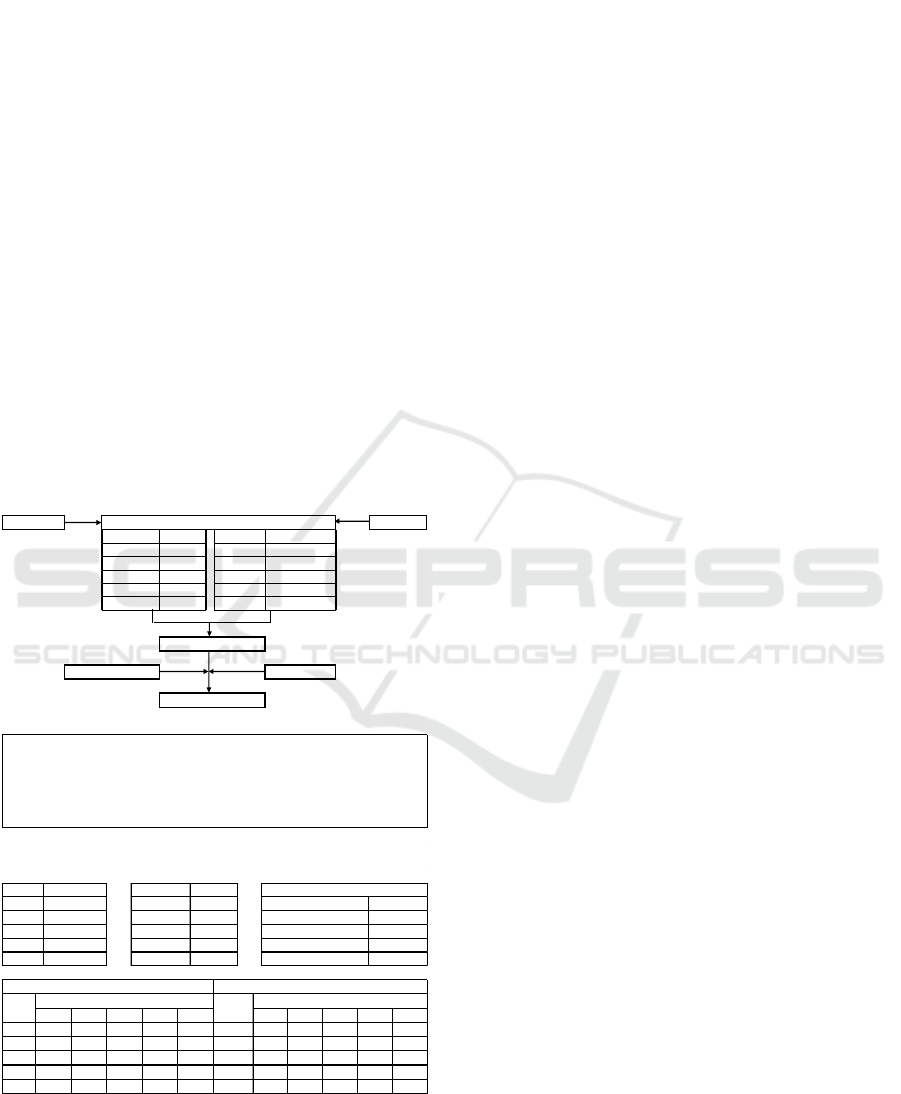
Figure 1: Procedure for Determining the Level of Critical
Land (Regulation of the Director-General of Watershed
Control and Protection Forest Management
No.P.3/PDASHL/SET/KUM.1/7/2018, 2018).
though its productivity is low. Identification of land
criticality is useful for determining conservation
policies used on critical land in the Badeng
watershed. The identification method used is scoring
and the reference used is the Regulation of the
Director-General of Watershed Control and
Protection Forest Management Number
P.3/PDASHL/SET/KUM.1/7/2018.
Based on Figure 1, the Erosion Map and Land Use
Map are scored. After that, overlay erosion map and
land use map. It is generating a first overlay map. The
scoring method is, for example, land use map 1 (rice
fields, ponds) has a score of 12 multiplied by a land-
use weight of 60%, and for example, the erosion that
occurs is <15 tons/ha/year has a score of 8 multiplied
by the weight erosion by 40%. After that, the
multiplication result is totaled between land use and
erosion. Then overlay the slope map and forest area
function map, resulting in a second overlay map,
which is called the critical land map. Classify the
criticality of the land on the second overlay map. The
example, an area inside a forest area with a slope of
0-8º and has a criticality score of 52-68, on area is
classified as Critical Potential (CP). Meanwhile, for
areas outside the forest area, if it has a slope of 0-8º
and has a criticality score of 68-84, then the area is
classified as Somewhat Critical (SC).
2.2 Land Conservation
Land conservation is the control of energy from the
effects of raindrops and surface runoff in the process
of erosion. The main objective in soil conservation is
to obtain a sustainable level of land production by
keeping the rate of soil loss below the permissible
threshold, which theoretically can be said that the rate
of erosion must be less than or equal to soil formation.
Since erosion is a natural process that cannot be
avoided at all or zero erosion, especially for
agricultural land, what can be done is to reduce the
rate of erosion to an acceptable level. There are
several types of conservation, namely, vegetative
conservation by planting in strips, multiple plantings,
rotational planting, using mulch, and forest farming
systems. Mechanical conservation using land
preparation according to contour lines, making
mounds, making drain, making waterways, making
check dams, making rorak, and making Gully Plugs.
In contrast, chemical conservation is conservation by
using chemicals.
Land Use Map Erosion Map
Land Use Class Score Erosion Class Score
112<15 8
2 24 15 - 60 16
3 32 60 - 180 24
4 48 180 - 480 32
5 60 >480 40
Slope M apFo re st Are a M ap
Scoring
Total Score
Land Criticality Map
Description of Land Use Score:
1
2
3
4
5
Shrubs, Swamp Shrubs, DryLand Farming, Mixed DryLand Agriculture
Open Land, Mining
Airport, Body of Water, Swamp, Savanna, Settlement / Transmigration, Primary DryLand
Forest, Rice Fields, Ponds, Primary Mangrove Forest, Secondary Mangrove Forest, Primary
Swamp Forest, Secondary Swamp Forest
Plantation Forest, Secondary DryLand Forest
Plantation
LU Class Weight 60% Erosion Rate Weight 40%
1 12 <15 8 Not Critical (NC) 0 - 36
2 24 15 - 60 16 Critical Potential (CP) 36 - 52
3 32 60 - 180 24 Somewhat Critical (SC) 52 - 68
4 48 180 - 480 32 Critical (C) 68 - 84
5 60 >480 40 Highly Critical (HC) >84
Sc oring Critic ality
Scoring System from the Regulation of the Director-General of Watershed and Protection Forest Management Number
P.3/PDASHL/SET/KUM.1 /7/2018
0 - 36 36 - 52 52 - 68 68 - 84 >84 0 - 36 36 - 52 52 - 68 68 - 84 >84
0 - 8 NC NC CP CHC0 - 8 NC NC CP SC SC
8 - 15 NC CP SC CHC8 - 15 NC CP SC SC SC
15 - 25 CP SC SC CHC15 - 25 CP SC SC CHC
25 - 40SCSCSC CHC25 - 40 SC SC SC CHC
>40SCSCSC CHC>40SCSCSC CHC
Critic a l Sc ore
Inside of Forest Area Outside of Forest Area
Critical Score
Slope Slope
Identification of Land Criticism for Land Conservation Actions in the Badeng Watershed with Regulation of Watershed and Protection
Forest Management
485
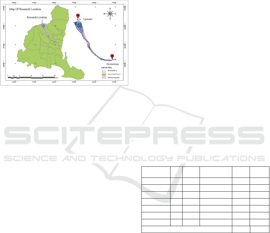
2.3 Location of Study
The research location was in the Badeng Watershed,
Banyuwangi Regency which has an area of 52.40 km
2
and located at geographic coordinates 8° 6’ 12.367" S
to 8° 20’ 19.109" S, and 114° 6’ 34.242" E to 114°
19’ 15.679" E [4], as in the Figure 2.
Figure 2: Location of Research in Badeng Watershed of
Banyuwangi Regency.
2.4 Data Collection
Primary data in the form of field survey results and
coordinates of land criticality areas and secondary
data in the form of spatial data are the digital map of
Badeng watershed erosion, digital map of the land use
of Badeng watershed, digital map of forest area
function in Badeng watershed, digital map of the
slope of Badeng watershed, digital map
administration of the Badeng watershed, and a digital
map of the river of the Badeng watershed obtained
from the Regional Development Planning Agency of
Banyuwangi Regency.
2.5 Step Work
2.5.1 Identification of Land Criticality
Identification of land criticality is carried out to
determine areas affected by erosion due to flooding in
the Badeng watershed. The identification of land
criticality is carried out using the scoring method,
referring to the Regulation of the Director-General of
Watershed Control and Protection Forest
Management Number of P.3/PDASHL/SET/ KUM.1/
7/ 2018.
2.5.2 The Making of a Land Criticality Map
The making of a land criticality map is carried out
using a Geographic Information System by
overlaying a base map of land criticality parameters
that have been scored based on the criticality level of
the land in the Regulation of the Director-General of
Watershed Control and Protection Forest
Management Number of P.3/PDASHL/SET/ KUM.1/
7/ 2018.
2.5.3 Study of Critical Land Conservation
Surveying conditions in the field carried out the study
of critical land conservation at critical land points
resulting from processing map overlay data using
Geographic Information Systems. This analysis was
carried out for conservation recommendations on
critical land in the Badeng watershed, Songgon,
Banyuwangi.
3 RESULT AND DISCUSSION
3.1 Land Use
Land use is used to provide an overview of the types
of land use in the watershed. Factors such as
biophysical, economic, and social conditions become
the basis for land planning to preserve the
environment and utilize land according to the area's
capacity, function, and potential. The percentage and
area of land use distribution in the Badeng watershed
can be seen in Table 1.
Table 1: Badeng Land Use Scoring.
Land Use LU Score
Total Score
(Score x 60%)
Area
(Km
2
)
%
Area
Forest 1 12 7.2 32.35 61.76
Garden 4 48 28.8 13.69 26.13
Avalanches 5 60 36 1.92 3.67
Land Waters 1 12 7.2 1.26 2.40
Plantation 3 32 19.2 2.44 4.66
Settlement 1 12 7.2 0.17 0.33
Rice Fields 1 12 7.2 0.56 1.06
Total 52.38 100
Based on Table 1, it can be seen that the land use
in the Badeng watershed is dominated by forest, with
a percentage of the land area of 61.75% or 32.35 Km
2
.
The land use map can be seen in Figure 2.
iCAST-ES 2021 - International Conference on Applied Science and Technology on Engineering Science
486
Figure 3: Land Use Map of the Badeng Watershed.
The distribution of land use in Figure 3, shows
seven types of land use, namely forest, rice fields,
plantations, gardens, settlements, avalanches, and
land waters. Land use in the Badeng watershed is
dominated by forest, while settlements have the least
land use.
3.2 Erosion
Erosion is very influential on the criticality of the
land. Part of the soil will be eroded and transported
by water or wind and then settles somewhere. This
incident resulted in a decrease in land productivity in
the Badeng watershed. The erosion score in the
Badeng watershed is shown in Table 2.
Table 2: Erosion Scoring of Badeng Watershed.
Erosion Class
(Ton/Ha
/
Yrs)
Score
Total Score
(Score x 40%)
Captions
≤15 8 3.2 Excellen
t
15-60 16 6.4 Goo
d
60-180 24 9.6 Medium
>480 40 16 Very Bad
In Table 2, it is known that the erosion in the
Badeng watershed has been classified into 4 classes.
The class of ≤15 (Ton/Ha/Yrs) with an area of
98.93% is in the very excellent category. The erosion
class 15-60 (Ton/Ha/Yrs) with an area of 1.06% is in
a good category, the erosion class 60-180
(Ton/Ha/Yrs) with an area of 0.003% is in the
medium category, erosion class >480 (Ton/Ha/Yrs)
with an area of 0.011% is in the very bad category.
The erosion base map can be seen in Figure 4.
Figure 4: Erosion Map of the Badeng Watershed.
Based on Figure 4, it is known that the erosion rate
in the Badeng watershed is 13.037,07 tons/ha/year.
3.3 Slope
The slope base map is used to determine the criticality
level of the land. The steeper the slope, the higher the
land criticality potential. The slope classification of
the Badeng watershed is shown in Table 3.
Table 3: Classification of Slope In The Badeng Watershed.
Slope (%) Slope Class Conditions
Area
(
Km²
)
%
Area
0 – 2 I Flat 2.97 5.68
2 - 8 II Sloping 23.69 45.24
8 - 15 III Bit Steep 6.91 13.19
15 - 25 IV Bit Steep 7.98 15.23
25 - 40 V Steep 4.11 7.84
>40 VI Ver
y
Stee
p
6.71 12.81
Total 52.38 100
Based on Table 3, it is known that the average
slope distribution of the Badeng watershed varies
from a slope of 0-2%, having an area of 5.68% with
flat conditions, a slope of 2-8% having an area of
45.24% with sloping conditions, a slope of 8%-15%
having a wide percentage of 13.19% with bit steep
conditions, a slope of 15-25% has a percentage of the
area of 15.23% with a bit steep condition, a slope of
25-40% has a percentage of 7.84% with a steep
condition, a slope of >40% has an area percentage of
12.81% with very steep conditions. The basic map of
the slope in the Badeng watershed is shown in Figure
5.
Identification of Land Criticism for Land Conservation Actions in the Badeng Watershed with Regulation of Watershed and Protection
Forest Management
487
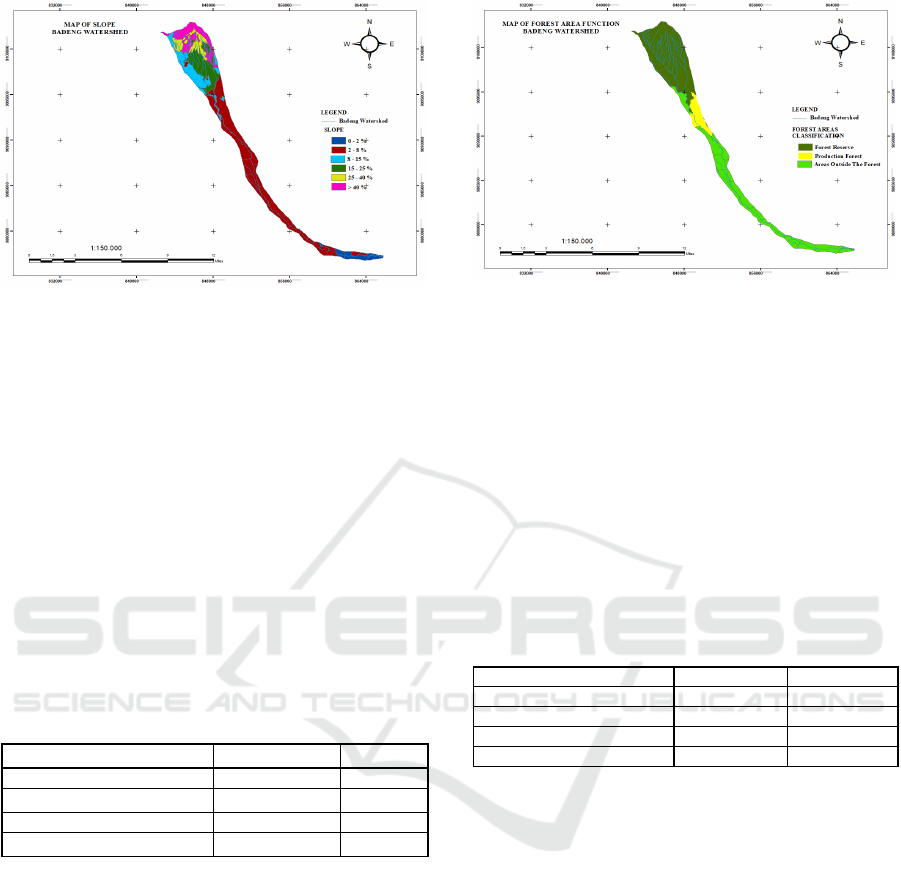
Figure 5: Slope Map of the Badeng Watershed.
Based on Figure 5, it is known that the slope of 0
– 2% has an area of 2.97 Km
2
. The slope of 2 – 8%
has an area of 23.69 Km
2
. the slope of 8 – 15% has an
area of 6.91 Km
2
. The slope of 15 – 25% has an area
of 7.98 Km
2
, the slope 25 – 40% has an area of 4.11
Km
2
, slopes >40% have an area of 6.71 Km
2
.
3.4 Forest Area
Forest area is used to determine the forest area in the
Badeng watershed. Forest areas also have a function
to regulate water systems, control erosion, and
maintain soil fertility. The classification of the
Badeng watershed forest area can be seen in Table 4.
Table 4: Classification of Forest Area in Badeng
Watershed.
Classification Area (Km²) % Area
Areas Outside the Fores
t
20.51 39.15
Protected Forest 27.69 52.84
Production Fores
t
4.19 8.01
Total 52.40 100
Based on Table 4, the forest area in the Badeng
watershed is dominated by protection forest with
52.84%, outside forest area of 39.15%, and
production forest of 8.01%. The Forest Area Base
Map can be seen in Figure 6.
Figure 6: Map of Badeng Watershed Forest Area.
3.5 Land Criticism
Land cannot function properly according to its
designation, both as a production medium and water
management medium. Land classified as critical can
be in the form of bare soil with no vegetation at all,
savanna fields, or land overgrown with unproductive
shrubs, rocky areas, ravines, or ditches resulting from
soil erosion. The following is the classification of
critical land in the Badeng watershed, which can be
seen in Table 5.
Table 5: Classification of Critical Land In Badeng
Watershed.
Classification Area (Km
2
) % Area
Somewhat
/
Rathe
r
Critical 10.82 20.65
Critical Potential 8.08 14.43
No
t
Critical 33.49 63.93
Total 52.38 100
The results of land criticality analysis in the
Badeng watershed according to Table 5 based on the
Regulation of the Director-General of Watershed
Control and Protection Forest Management Number
P.3/PDASHL/SET/KUM.1/7/2018 obtained three
land criticality classifications with the results of non-
critical land zones which is 33.49 km
2
or 63.93%. The
critical potential zone is 8.08 Km
2
or 14.43%. While
the Somewhat/ rather critical zone is 10.82 km
2
or
20.65%.
iCAST-ES 2021 - International Conference on Applied Science and Technology on Engineering Science
488
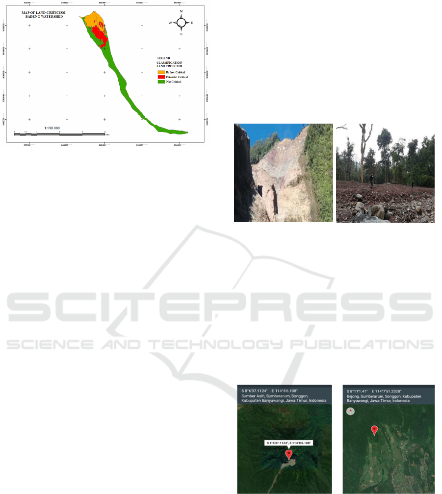
Figure 7: Map of Land Criticality in Badeng Watershed.
Figure 7 is a map of the results of land criticality
analysis in the Badeng watershed according to the
Regulation of the Director-General of Watershed
Control and Protection Forest Management Number
P.3/ PDASHL/ SET/ KUM.1/ 7/2018 which can be
grouped into three land criticality zones, namely:
a. The somewhat/ rather critical zone of 10.82 km
2
is located in Sumber Asih Hamlet, Mangaran,
Sumberarum Village, Bayu Lor Hamlet,
Sambungrejo, Bayu Village, Songgon District
with a slope of 25-40% and >40%. The types of
land use are forest and landslide. The function of
the forest area in this zone is a protected forest.
The amount of erosion is 9162.10 Ton//Ha/Yrs
located at the coordinates of Longitude
114.131832 E, Latitude -8.117319 S.
b. The critical potential zone of 8.08 Km
2
is located
in Bejong Hamlet, Krajan Sumberarum Village,
Bayurejo Hamlet, Bumisari, Kentangan,
Tegalrejo, Bayu Village, Songgon District with a
slope of 8-15% and 15-25%. The types of land use
are forest and landslide. The function of the forest
area in this zone is the area outside the forest and
protected forest. The amount of erosion is 34.45
Tons//Ha/Yrs located at the coordinates of
Longitude 114.151463 E, Latitude -8.148847 S.
c. The non-critical zone of 33.49 km
2
is located in
Sumberbulu Village, Singojuruh, Kampung
Anyar Hamlet, Lider, Sumberarum Village,
Sumberbaru, Bubuk, Gladag, Benelan Kidul,
Songgon, Parangharjo, Kemiri, Bedewang,
Cantuk, Alasmalang, Pelantaran Village Bayu
Hamlet, Songgon District, Singojuruh, and
Rogojampi with a slope of 0 - 2%, 2-8%, and 8-
15%. Types of land use are settlements, inland
waters, plantations, rice fields, gardens, forests,
and forest area functions are outside forest areas,
protected forests, and production forests. The
amount of erosion is 3840.52 Ton//Ha/yrs at the
coordinates of Longitude 114.16574 E, Latitude -
8.186919 S.
In Figure 8, the condition of the land area is rather
critical at coordinates 8° 6' 37.1124" South Latitude
and 114° 8' 6.108" East Longitude. The land use in
the area is the forest with no vegetation, and there are
former landslides. The potential on slightly critical
land can cause high surface runoff if the rainfall
intensity is high.
(a) (b)
Figure 8: Zone of Somewhat Critical Area In Sumberarum
Village (a) Former Landslide on Mount Pendil (b) Forest
on the Slope of Mount Pendil
Mountain areas are synonymous with green,
fertile areas, and there are lots of forests, so they are
rich in oxygen. However, it turns out that
mountainous areas or highlands in the Raung
Mountains can also experience land criticality. The
cause is soil erosion and landslides with soil types in
the form of grumosol and mediteran. In addition,
other factors are land conversion, mismanagement of
land, and lack of water and soil conservation.
(a)
(b)
Figure 9: (a) Location of Somewhat Critical Zone in the
Pendil Mountains, Sumberarum Village, Songgon District;
(b) Critical Potential Zone in Sumberarum Village,
Songgon District.
Figure 9 is a somewhat critical zone in the
mountainous area of Pendil, Sumberarum Village,
Songgon District. The Land Use in this zone is a
landslide, having a slope of >40%. The conditions of
critical potential areas located in Sumberarum
Identification of Land Criticism for Land Conservation Actions in the Badeng Watershed with Regulation of Watershed and Protection
Forest Management
489

Village, Songgon District at coordinates 8° 11' 1.40"
South Latitude, and 114° 8' 51.2328" East Longitude.
The type of land use in this area is a forest area in the
form of a savanna. Therefore, the critical potential
zone in Sumberarum Village, Songgon District. The
land use in this zone is forest, with a slope of 8-15%.
The condition of the rice fields around the banks
of the Badeng River located in Kemiri Village,
Songgon District at coordinates 8° 17' 35.394" South
Latitude, 114° 12' 58.464" East Longitude, where in
the area is not a critical zone but still contributes to
land erosion and flood zones.
3.6 Land Conservation Study
Efforts that can be made to prevent or minimize the
adverse impacts of land criticality are by conducting
conservation in the Badeng watershed. The following
are conservation recommendations in the Badeng
watershed:
a. Somewhat Critical Zone
Conservation recommendations for the somewhat/
rather critical zone are vegetative conservation in the
form of planting citronella and vetiver grass for
critical land management and anticipation of
landslides and reforestation in the Raung mountain
forest area. For plantation areas, coffee and cloves are
planted with mechanical conservation to make rorak.
b. Critical Potential Zone
Conservation recommendations for potential critical
zones are vegetative conservation by planting teak,
pine, and mahogany trees with multiple cropping
systems or agroforestry systems, meanwhile, for
mechanical conservation in the form of making check
dams and gully plugs in grooves, ditches, or ravines
around the slopes and banks of the Badeng River.
c. Non-critical Zone
Conservation recommendations for non-critical zones
are vegetative conservation by planting rotational
cropping systems and mulch in agricultural areas.
Meanwhile, for mechanical conservation in making
mounds and making terraces in highland agricultural
areas.
4 CONCLUSIONS
The identification of land criticism for land
conservation actions in the Badeng watershed with
Regulation of Watershed and Protection Forest
Management can be concluded as follows:
a. Slightly critical land of 20.65% with 10.82 Km
2
is
located in Sumber Asih Hamlet, Mangaran,
Sumberarum Village, Bayu Lor Hamlet,
Sambungrejo, Bayu Village, Songgon District.
Recommendations for vegetative conservation in
the form of planting citronella and vetiver grass
for critical land management and anticipation of
landslides and reforestation in the Raung
mountain forest area. For plantation areas, coffee
and cloves are planted with mechanical
conservation in the form of making rorak.
b. Critical potential land is 14.43% with 8.08 Km
2
in
Bejong Hamlet, Krajan Sumberarum Village,
Bayurejo Hamlet, Bumisari, Kentangan,
Tegalrejo, Bayu Village, Songgon District.
Recommendations for vegetative conservation by
planting teak, pine, and mahogany trees with
multiple cropping systems or agroforestry
systems, meanwhile, for mechanical conservation
in the form of making check dams and gully plugs
in grooves, ditches, or ravines around the slopes
and banks of the Badeng River.
c. Non-critical land is 63.93% of 33.49 km
2
located
in Sumberbulu village, Singojuruh, Kampung
Anyar hamlet, Lider, Sumberarum Village,
Sumberbaru, Bubuk, Gladag, Benelan Kidul,
Songgon, Parangharjo, Kemiri, Bedewang,
Cantuk, Alasmalang, Pelantaran Hamlet Bayu
Village, Songgon District, Singojuruh,
Rogojampi. Recommendations for vegetative
conservation by planting rotational cropping
systems and using mulch in agricultural areas. For
mechanical conservation in the form of making
mounds and making terraces in highland
agricultural areas.
ACKNOWLEDGEMENTS
Thanks to Politeknik Negeri Banyuwangi for funding
the Research Master Plan-Based Research scheme in
2021. The second time to the research team for their
cooperation so that this research can be completed.
REFERENCES
Asmaranto, R., Suhartanto, E., & Permana, B. A. (2012).
Aplikasi Sistem Informasi Geografis (SIG) untuk
identifikasi lahan kritis dan arahan fungsi lahan Daerah
Aliran Sungai Sampean. Jurnal Teknik Pengairan:
Journal of Water Resources Engineering, 1(2), 84-105.
Erwanto, Z., & Lestari, N. (2020). Study of Rainfall
Erosivity and Erosion Rate with MUSLE Method Using
iCAST-ES 2021 - International Conference on Applied Science and Technology on Engineering Science
490

Geographic Information System In Badeng Watershed.
International Conference on Applied Science and
Technology on Engineering Science 2020. Politeknik
Negeri Padang.
Erwanto, Z., & Pratiwi, D.A. (2020). Application of
Geographic Information System For The Identification
of Flood And Landslide Mitigation In Badeng
Watershed. International Conference on Applied
Science and Technology on Engineering Science 2020.
Politeknik Negeri Padang.
Erwanto, Z., Holik, A., Pranowo, D.D., Prastyo, S.D.B.,
and Husna, A. (2020). Hydrological Modeling Using
SWAT Due to Landslides In The Badeng Watershed.
International Conference on Applied Science and
Technology on Engineering Science 2020. Politeknik
Negeri Padang.
Hendro, H., Nadhi, Z., Budiastuti, S., & Purnomo, D.
(2014). Pemetaan Lahan Kritis di Kawasan Muria
untuk Meningkatkan Daya Dukung Lingkungan yang
Berbasis pada Sistem Informasi Geografis (SIG). Ilmu
Pertanian (Agricultural Science), 17(1), 46-51.
Hidayat, R., & Iswardoyo, J. (2019). Banjir Bandang Di
Alasmalang Banyuwangi Dan Alternatif
Penanganannya (Flash flood at Alasmalang
Banyuwangi and alternatives for its completion). Jurnal
Penelitian Pengelolaan Daerah Aliran Sungai (Journal
of Watershed Management Research), 3(2), 127-140.
Kadir, S., & Badaruddin, B. (2015). Pengayaan Vegetasi
Penutupan Lahan Untuk Pengendalian Tingkat
Kekritisan DAS Satui Provinsi Kalimantan Selatan.
Jurnal Hutan Tropis, 3(2).
Kementrian Lingkungan Hidup Dan Kehutanan Direktorat
Jenderal Pengendalian Daerah Aliran Sungai Dan
Hutan Lindung. (2018). Peraturan Direktur Jenderal
Pengendalian Daerah Aliran Sungai Dan Hutan
Lindung Nomor P.3/PDASHL/SET/KUM.1/7/2018.
Jakarta.
Nurhakim, K. (2017). Studi Perubahan Tingkat Lahan
Kritis Lingkungan DAS Dengan Metode Pengideraan
Jauh (Studi Kasus: Kabupaten Sampang, P. Madura)
(Doctoral dissertation, Institut Teknologi Sepuluh
Nopember).
Prasindya, P., Hariyanto, T., & Kurniawan, A. (2020).
Analisis Potensi Tanah Longsor Menggunakan Sistem
Informasi Geografis dan Analytical Hierarchy Process
(AHP) (Studi Kasus: Kecamatan Songgon, Kabupaten
Banyuwangi). Geoid, 16(1), 19-27.
Rachmawati, I. (2018). Banjir Bandang Disebabkan
Gerakan Tanah di Lereng Gunung Raung. Banyuwangi:
Kompas. https://regional.kompas.com/read/2018/06/
22/21493391/anas-banjir-bandang-disebabkan-
gerakan-tanah-di-lereng-gunung-raung?page=all
Ramayanti, L. A., Yuwono, B. D., & Awaluddin, M.
(2015). Pemetaan Tingkat Lahan Kritis Dengan
Menggunakan Penginderaan Jauh Dan Sistem
Informasi Geografi (Studi Kasus: Kabupaten Blora).
Jurnal Geodesi Undip, 4(2), 200-207.
Identification of Land Criticism for Land Conservation Actions in the Badeng Watershed with Regulation of Watershed and Protection
Forest Management
491
