
Garlic Land Suitability System based on Spatial Decision Tree
Imas Sukaesih Sitanggang
1
, Andi Nurkholis
1
, Annisa
1
and Muhammad Asyhar Agmalaro
1
1
Department of Computer Science, IPB University, Darmaga,Jl. Meranti Wing 20, Level V,Bogor 16680, Indonesia
Keywords:
classification, decision tree, garlic, land suitability, spatial ID3 algorithm
Abstract:
Domestic garlic needs are not equal to the production level that leads to high import of garlic to meet the
domestic consumption. Land suitability identification for garlic is required in order to increase domestic
garlic production. The spatial classification method can be used to determine garlic land suitability classes
based on the garlic planting criteria. This study aims to develop a web-based application to visualize the garlic
land suitability classes based on the spatial decision tree which was created using the spatial ID3 algorithm.
The application has four main functions namely visualization of garlic land suitability in map, user profile
management, land suitability information, and garlic varieties information.
1 INTRODUCTION
Garlic is one of the horticultural crops commodities
that are needed by most of Indonesian, especially for
consumption as a cooking spice and food flavoring.
Local garlic production in 2016 is 21,150 thousand
tons however the need of garlic reach 470,031 thou-
sand tons and it increases 8.78% in average per year
(BPS, 2017). Domestic garlic needs are not equal to
the production level, therefore import is done in order
to meet the domestic garlic consumption. The low
garlic production is the basis for the government to
launch a projection of garlic self-sufficiency. In 2020-
2029 the government will develop an area for growing
garlic. The plan aims to increase the level of domes-
tic garlic production (Holtikultura, 2017). There is
a problem in preparing the area for planting garlic,
namely the lack of land for garlic, so identifying the
land suitability of garlic id required (Statistik, 2015).
Land suitability identification is conducted using land
suitability analysis techniques.
Land suitability evaluation is the process of esti-
mating land suitability classes and potential land uses
for agriculture. Land suitability class describes the
level of land suitability for a particular use. Land eval-
uation is conducted to assess the potential of land for
a certain crop by providing the growth requirements
for the crop.
Studies on land suitability have been done by
many researchers in several countries including In-
donesia.
A spatial model for land suitability evaluation for
wheat crop integrated with Geographical Information
System (GIS) was proposed (El Baroudy, 2016). The
proposed model showed that about 71.44% of the to-
tal area fall within the highly suitable class and the
moderately suitable class for wheat crop. (Chairani
et al., 2017) determines the physical land suitabil-
ity for civet Arabica coffee in Bandung and Bandung
Barat, Indonesia based on the criteria temperature,
rainfall, humidity, duration of dry season, slope, al-
titude, type of soil, soil texture, and erosion potential.
Land suitability using GIS for annual crops: Thanh
Tra pomelo, rubber, and stAcacia mangium in Thua
Thien Hue province Vietnam was evaluated based on
soil type, slope, terrain elevation, soil layer thickness,
mechanical composition, humus content, bio-climatic
conditions and irrigation (Dan, Ping and Lang, 2018).
The level of suitability to shallot and lemon in Harian
District, Samosir Regency Indonesia was determined
in the previous study (Tampubolon et al., 2018). (Se-
tyowati et al., 2018) estimates both production and
productivity of rice, maize, and cassava using land
suitability approach in Karangasem Regency, Bali In-
donesia. This study applied remote sensing and GIS
techniques. An assessment on a spatial basis was
conducted using GIS for agricultural land suitability
evaluation of rice (irrigated paddy field, rainfed rice)
and corn (Ramlan et al., 2018). Spatial data used in
this study include digital topographic map, soil sur-
vey, soil characteristics, as well as climate data.
GIS and remote sensing technology have been
widely used in studies of land suitability evaluation.
However, the land suitability evaluation requires large
206
Sitanggang, I., Nurkholis, A., Annisa, . and Agmalaro, M.
Garlic Land Suitability System based on Spatial Decision Tree.
DOI: 10.5220/0009908002060210
In Proceedings of the International Conferences on Information System and Technology (CONRIST 2019), pages 206-210
ISBN: 978-989-758-453-4
Copyright
c
2020 by SCITEPRESS – Science and Technology Publications, Lda. All rights reserved
spatial data of crop planting conditions especially for
large study area. In order to obtain interesting patterns
from the large spatial data in evaluating land suitabil-
ity, spatial data mining can be applied. One of spatial
algorithms that can be used in modelling land suitabil-
ity for crop is spatial decision tree. A spatial decision
tree is a classification model for determining the class
label of objects based on their characteristics. Our
previous study has been successfully a spatial deci-
sion tree for garlic land suitability in Magetan district,
East Java province and Solok district, West Sumatra
province Indonesia. However, the model could not
easily be interpreted by users. Therefore, this study
aims to develop a visualization module of spatial de-
cision tree for garlic land suitability. The following
discussion is divided as follows. Section 2 discusses
data, study area, and briefly explain the methods ap-
plied in this study. Result and discussions are briefly
discussed in Section 3. We summarize our work and
future work in Section 4.
2 METHODS
2.1 Data
The study area is Magetan district, East Java province
Indonesia with an area of 70,143 ha (dan Pengemban-
gan Sumberdaya Lahan Pertanian (BBSDLP), 2017)
and Solok district, West Sumatra province Indonesia
with an area of 335,086.53 ha (dan Pengembangan
Sumberdaya Lahan Pertanian (BBSDLP), 2017). The
two districts are predicted to be the center for pro-
ducing garlic for Indonesia in the future (Holtikultura,
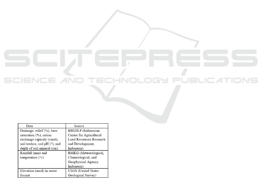
2017). The data used in this study are provided in Fig-
ure 1.
Figure 1: Data and Its Source.
2.2 Research Step
This study was conducted in several steps includ-
ing data preprocessing, spatial decision tree model
and developing a visualization module for garlic land
suitability. In the data pre-processing stage, we per-
formed spatial interpolation for weather data using the
ordinary co-kriging (Adhikary et al., 2017). In addi-
tion, spatial operations were applied on Digital Eleva-
tion Model (DEM) data to produce an elevation layer
in vector format. Explanatory and target layers for
spatial task relevant data were prepared after spatial
feature validity test was performed.
Spatial decision tree was created on the garlic
planting criteria dataset using the algorithm the spa-
tial ID3 algorithm (Sitanggang et al., 2013). The use
of spatial decision tree algorithms is based on the im-
portance of considering spatial data relations (i.e., po-
sition, distance, orientation, etc.) in the analysis of
geographically referenced data carried out in this case
of land suitability (Rinzivillo and Turini, 2004). The
tree was developed by splitting the spatial dataset into
smaller datasets by selected the best feature for data
partition. The measurement used to select the split-
ting feature is spatial information gain in which the
features with the highest spatial information gain will
be selected as the label of root of sub tree in each it-
eration.
The visualization module of spatial decision tree
was developed in order to provide the classification
model for garlic land suitability. There are four main
functions available in the system namely 1) visualiza-
tion of garlic land suitability in map, 2) user profile
management, 3) Land suitability information, and 4)
Garlic varieties information. The system was devel-
oped using the following software:
• Laravel as the backend framework to integrate
database and the user interface
• Bootstrap as the front end to provide webbased
interface
• Leaflet.js is used as the API frontend of map at
web-based interface
• PostgreSQL with the PostGIS extension as spatial
database management system
3 RESULTS AND DISCUSSION
The spatial ID3 algorithm (Sitanggang et al., 2013)
was implemented on the garlic spatial dataset to result
a spatial decision tree for garlic land suitability. The
dataset contains ten explanatory layers and one target
layer which is Land suitability. The attributes of each
layer for two study area namely Magetan dan Solok
are provided in Figure 2.
Garlic Land Suitability System based on Spatial Decision Tree
207
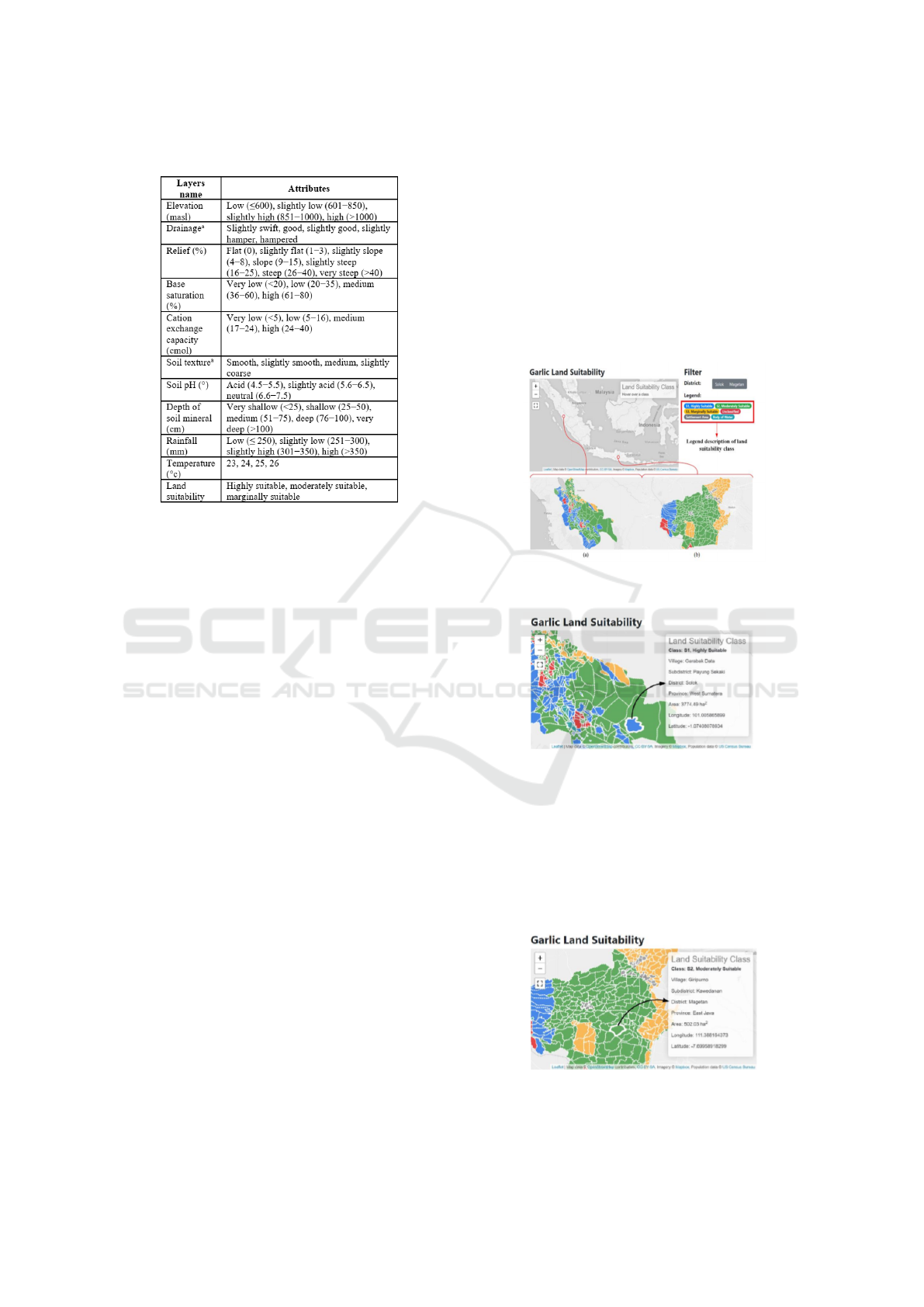
space
Figure 2: Spatial Data of The Garlic Planting Criteria.
The rules in land suitability evaluation can be ex-
tracted from garlic planting criteria dataset using the
classification method. The class labels of the dataset
in this classification task represent garlic land suitabil-
ity classes namely S1 (highly suitable), S2 (moder-
ately suitable), and S3 (marginally suitable).
The implementation of spatial ID3 algorithm on
Magetan dataset result as many 33 rules whereas on
the Solok dataset result as many 66 rules. The exam-
ples of rules generated from Magetan dataset are as
follows:
• IF relief = steep AND elevation = high AND tem-
perature = 24
◦
c AND rainfall = high AND depth
of soil mineral = deep AND Soil pH = slightly
acid AND soil texture = medium AND cation ex-
change capacity = low AND base saturation =
medium THEN land suitability = S1 (highly suit-
able)
• IF relief = steep AND elevation = low THEN land
suitability = S2 (moderately suitable)
• F relief = flat AND rainfall = rather low AND
depth of soil mineral = very deep THEN land suit-
ability = S3 (marginally suitable)
The examples of rules generated from Solok
dataset are as follows:
• IF soil texture = smooth AND cation exchange ca-
pacity = height AND depth of soil mineral = very
deep THEN land suitability = S1 (highly suitable)
• IF soil texture = smooth AND cation exchange
capacity = very low AND relief = slightly steep
AND elevation = rather high AND temperature =
25
◦
c AND rainfall = high THEN land suitability
= S2 (moderately suitable)
• IF soil texture = slightly coarse AND Soil pH =
acid and base saturation = height THEN land suit-
ability = S3 (marginally suitable)
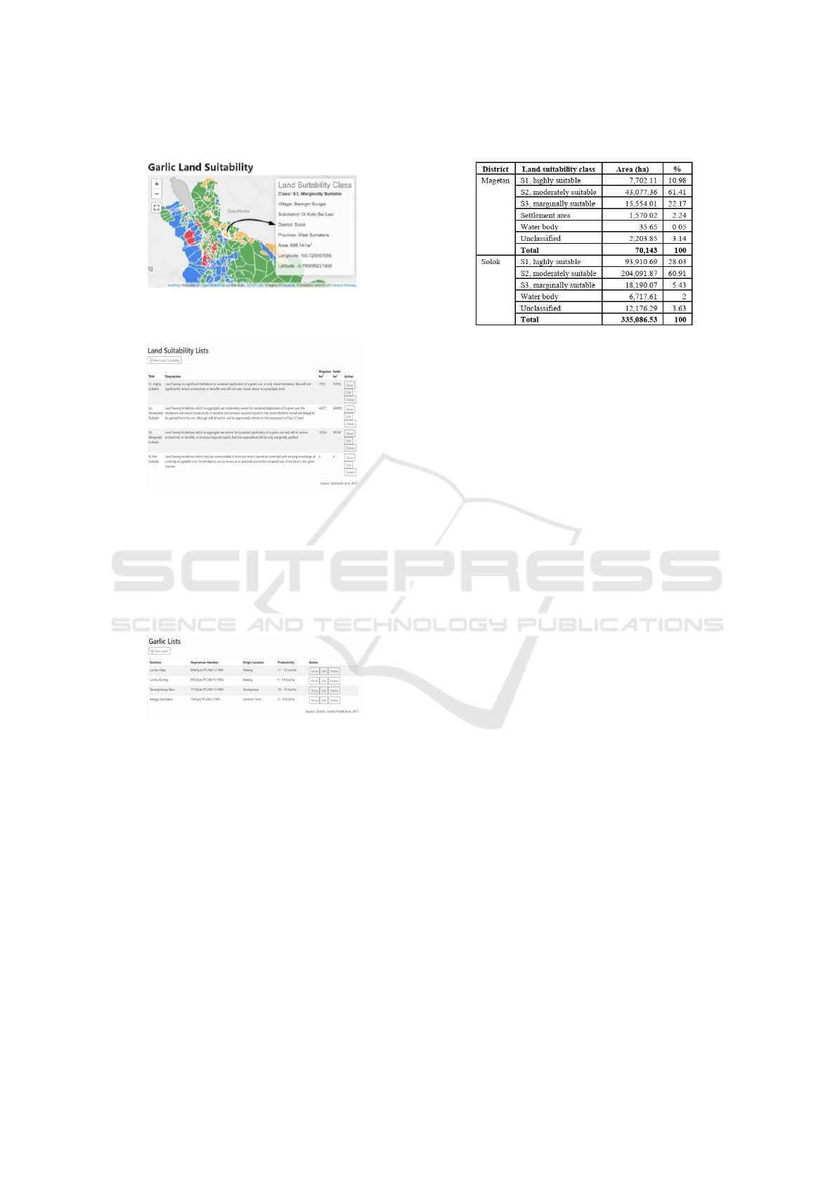
Figure 3 shows the Garlic land suitability in Solok
dan Magetan district. The area of garlic land suitabil-
ity for each class is illustrated in Figure 4, Figure 5
and Figure 6. While land suitability description and
garlic varieties recommended by the Indonesian gov-
ernment are shown in Figure 7 and Figure 8.
Figure 3: Garlic land suitability in (a) Solok dan (b) Mage-
tan
Figure 4: The area of garlic land suitability class S1 (highly
suitable) in Solok
The garlic varieties menu in Figure 8 provides
information on garlic varieties recommended by the
Ministry of Agriculture, which produces reliable seed
varieties with a yield of at least 9 tons/ha. This feature
can be used to obtain recommendation of garlic com-
modities to be cultivated in Indonesia, for the achieve-
ment of selfsufficiency in garlic by 2033.
Figure 5: The area of garlic land suitability class S2 (mod-
erately suitable) in Magetan
CONRIST 2019 - International Conferences on Information System and Technology
208
space
Figure 6: The area of garlic land suitability class S3
(marginally suitable) in Solok
Figure 7: Land suitability description
The land suitability description menu in Figure 7
provides information on land suitability classes and
their area in Solok and Magetan district. With this
feature, it is expected to provide information to rel-
evant parties (farmers, private sector, and Indonesian
government) in knowing the capabilities of Solok and
Magetan district for garlic farming.
Figure 8: Garlic varieties recommended by the Indonesian
government
Although land suitability analysis produces suit-
able class for garlic plant, it does not give a guarantee
that this area can be used for planting garlic. This
is because not all existing land use is used to grow
garlic. Figure 3 to Figure 6 show that there are la-
bels other than land suitability class (highly suitable,
moderately suitable, marginally suitable), namely set-
tlement area, water body, and unclassified. Therefore,
we need to decide the exiting land uses that can be
used for garlic plants. Figure 9 provides area of land
suitability class for garlic in Magetan and Solok dis-
trict.
space
Figure 9: Area of Land Suitability Class for Garlic.
In Figure 9 it can be seen that there are area that
cannot be planted with garlic because it has a func-
tion as settlement area and body of water. Settlement
area information indicates that cultivation/planting of
garlic in the area cannot be carried out due to social
conditions (the area is a community settlement), while
water body is an area that cannot be planted with gar-
lic because the terrain/location is water. The unclassi-
fied area label is an area where the rule based model
can not predict the land suitability classes. Unclas-
sified cases can be caused by the non-representative
dataset in creating classification models, so that when
the resulting rules are applied to data for spatial vi-
sualization, the data cannot be classified into a land
suitability class.
A desktop application for Indonesian crop land
suitability has been developed based on the fuzzy in-
ference system (Insani et al., 2015). In addition, an
expert system based on fuzzy genetic was built for
land suitability of paddy and corn (Hartati and Sitang-
gang, 2010). Both studies do not include the spatial
relations that appear in the data of growing require-
ment of crop. The advantage of this proposed system
is its ability to include the spatial relations as the im-
portant aspect in the land suitability evaluation.
The development of geographic information sys-
tem of garlic land suitability in this study is expected
to be used as an interactive mapping visualization that
can be directly accessed by the community. This
application may support the target of the Indone-
sian government in achieving garlic self-sufficiency
in 2033 which one way to reach this target is to ex-
pand the existing garlic farmland. The application de-
veloped in this study is expected to facilitate the de-
termination of suitable land areas for garlic farming,
especially in Magetan and Solok district. Informa-
tion on land suitability class is expected to reduce er-
rors in determining the area to be used as garlic farm-
ing which is very important, because it will affect the
amount of garlic production.
The main advantage of this system is that the sys-
Garlic Land Suitability System based on Spatial Decision Tree
209

tem provides more specific information about land
suitability, namely to the village level. The result of
this study also shows that a village can consist of more
than one land suitability class. The system has been
able to accommodate this situation by providing in-
formation on the area of a land suitability class in a
village. Thus, users are expected to know the area of
land suitability S1 / S2 / S3 in a village in detail. An
example can be seen in Figure 2., which shows the
Garabak Data village has two land suitability classes,
namely S1 (blue legend) and S2 (green legend), where
S1 has an area of 3,774.49 ha. It is also made easier by
the availability of longitude and latitude information
that will show users to get to a location more accu-
rately.
4 CONCLUSIONS
This study has been successfully implemented the vi-
sualization module for spatial decision tree represent-
ing garlic land suitability. The spatial ID3 algorithm
results 33 rules on Magetan dataset and 66 rules on
Solok dataset. Those rules were implemented in a
web-based application that represent the area of garlic
land suitability classes in Magetan and Solok Indone-
sia. System testing will be conducted as the future
work by comparing the output of the application to
the knowledge from experts and real garlic land suit-
ability in the study area.
ACKNOWLEDGEMENTS
The authors would like to thank to Directorate of
Research and Community Service, Ministry of Re-
search, Technology and Higher Education, Republic
of Indonesia for the research grant.
REFERENCES
Adhikary, S. K., Muttil, N., and Yilmaz, A. G. (2017). Cok-
riging for enhanced spatial interpolation of rainfall in
two australian catchments. Hydrological processes,
31(12):2143–2161.
Chairani, E., Supriatna, J., Koestoer, R., and Moeliono, M.
(2017). Physical land suitability for civet arabica cof-
fee: Case study of bandung and west bandung regen-
cies, indonesia. In IOP Conference Series: Earth and
Environmental Science, volume 98, page 012029. IOP
Publishing Ltd.
dan Pengembangan Sumberdaya Lahan Pertanian (BBS-
DLP), B. B. P. (2017). Peta tanah semidetail kabu-
paten solok besar skala 1: 50.000. bogor (id).
Hartati, S. and Sitanggang, I. S. (2010). A fuzzy based
decision support system for evaluating land suitabil-
ity and selecting crops. Journal of Computer Science,
6(4):417.
Holtikultura, D. J. (2017). Pengembangan bawang putih
nasional.
Insani, F., Sitanggang, I. S., et al. (2015). Expert system
modeling for land suitability based on fuzzy genetic
for cereal commodities: Case study wetland paddy
and corn. Telkomnika, 13(3).
Ramlan, A., Baja, S., Arif, S., and Neswati, R. (2018).
Gis-based agroecological assessment of land suitabil-
ity for food crop development at a regional scale: A
study case of buton island. In IOP Conference Series:
Earth and Environmental Science, volume 157, page
012024. IOP Publishing.
Rinzivillo, S. and Turini, F. (2004). Classification in ge-
ographical information systems. In European Con-
ference on Principles of Data Mining and Knowledge
Discovery, pages 374–385. Springer.
Setyowati, H., Murti, S., Nurani, R., Susanti, E., Puspi-
tasari, S., Ariyani, R., Firdausi, A., et al. (2018). Ap-
plied geo-eye imagery and gis for estimating crop pro-
duction based on land suitability in karangasem re-
gency, bali. In IOP Conference Series: Earth and En-
vironmental Science, volume 165, page 012025. IOP
Publishing.
Sitanggang, I. S., Yaakob, R., Mustapha, N., and Ainud-
din, A. (2013). Classification model for hotspot occur-
rences using spatial decision tree algorithm. Journal
of computer science, 9(2):244.
Statistik, B. P. (2015). Produksi, luas panen dan produktiv-
itas sayuran di indonesia. Badan Pusat Statistik dan
Direktorat Jenderal Hortikultura, Jakarta.
Tampubolon, E. et al. (2018). Evaluation of land suitability
for shallot (a. ascalonicum l.) and orange (orange sp.)
at harian district of samosir regency. In IOP Confer-
ence Series: Earth and Environmental Science, vol-
ume 122, page 012035. IOP Publishing.
CONRIST 2019 - International Conferences on Information System and Technology
210
