
Study for Development of Geotourism Potential in Edi Village Timor
Leste
Belazario Gusmão F. M. de Araujo
1
, Emeliano M. G. de Oliveira
1
, Nindyo Cahyo Kresnanto
2
,
Buddewi Sukindrawati
2
and Muhammad Kunta Biddinika
2
1
KM Consulting, Caicoli, Dili, Timor Leste
2
Department of Civil Engineering, Universitas Janabadra, Yogyakarta 55231, Indonesia
Keywords: Edi Maubisse, Geomorphosite, Geosite, Geotourism.
Abstract: Maubisse is one of the administrative posts of the Ainaro in Timor Leste, which is known to have a very high
interest of tourist attractions because of its cold weather and beautiful mountain views. However, those
attractive natural phenomena have not been fully used yet as educational attractions (as geotourism). The
purpose of this study is to conduct an inventory and interpretation of the geotourism potential in Maubisse,
especially in Suco Edi. This research was conducted in three phases: literature study, field research and data
analysis of the geotourism potential using quantitative and descriptive methods. The data analysis method
used was geosite and geomorphosite assessment based on certain parameters according to Kubalíková (2013).
The parameters used were scientific and intrinsic values: education, economy, conservation, and added value
possessed by a geosite.
1 INTRODUCTION
Geotourism is a scenic spot of natural tourism where
the main object is geodiversity through geological
tourism attraction to tourists, natural science
education and environmental conservation based on
geological phenomena. Accordingly, it can attract the
attention of tourist to visit the geotourism area and
will increase the local community’s income
economically (Rachmat, H., 2017).
Geotourism was first defined (Hose TA, 1995) in
England. There are two viewpoints of geotourism:
Purely geological and geomorphologically focused
Sustainable Tourism and Geographically Sustainable
Tourism, this emphasizes preservation of the
geographical sense of a place in general, beyond
simple geological and geomorphological features.
The aim of geotourism is to make visitors aware of,
and to gain some understanding of, the geological
features that surround them. Geotourism itself is a
tourist activity that is specifically focused on the
panorama and geological aspects (Newsome and
Dowling 2010). At its simplest geotourism is tourism
with some connection to geology or geomorphology
Development of certain areas into a Geotourism
region will certainly give a good impact people's lives
in various aspects of life such as economic, social,
cultural, and infrastructure. However, in determining
an area as a geotourism area, it needs to be analyzed
first. The analysis generally carried out is geosite and
geomorphosite analysis. Geosite and Geomorphosite
are landscapes that have potential as tourism sites and
have a value based on the perspective of human
assessment (Kubalíková, 2013). This analysis is
intended to provide an assessment of the specific
parameters such as the value of a scientific approach,
educational value, economic value, conservation
value and the value-added (beauty, cultural,
geological factors) in certain areas (Kubalíková,
2013).
2 RELATED WORKS
Maubisse (Maubesse, Mau-Bessi, Maobisse,
Maubise) is a historic town in the hills 70 km south of
Dili. It is one of the administrative posts of the
Ainaro, Timor Leste which is known to have a very
high interest of tourist attractions because of its cold
weather and beautiful mountain views. It’s about 3
hours traveling from Dili by motorbike and car and
from Maubisse town to Edi Village basically takes
about 1 hour by Motor and Car. Elevation and
coordinates: Elevation (approx.): 1430m Latitude
F.M. de Araujo, B., Oliveira, E., Kresnanto, N., Sukindrawati, B. and Biddinika, M.
Study for Development of Geotourism Potential in Edi Village Timor Leste.
DOI: 10.5220/0009880001550159
In Proceedings of the 2nd International Conference on Applied Science, Engineering and Social Sciences (ICASESS 2019), pages 155-159
ISBN: 978-989-758-452-7
Copyright
c
2020 by SCITEPRESS – Science and Technology Publications, Lda. All rights reserved
155
(Lat): 8°50'17"S Longitude (Lon): 125°35'50"E
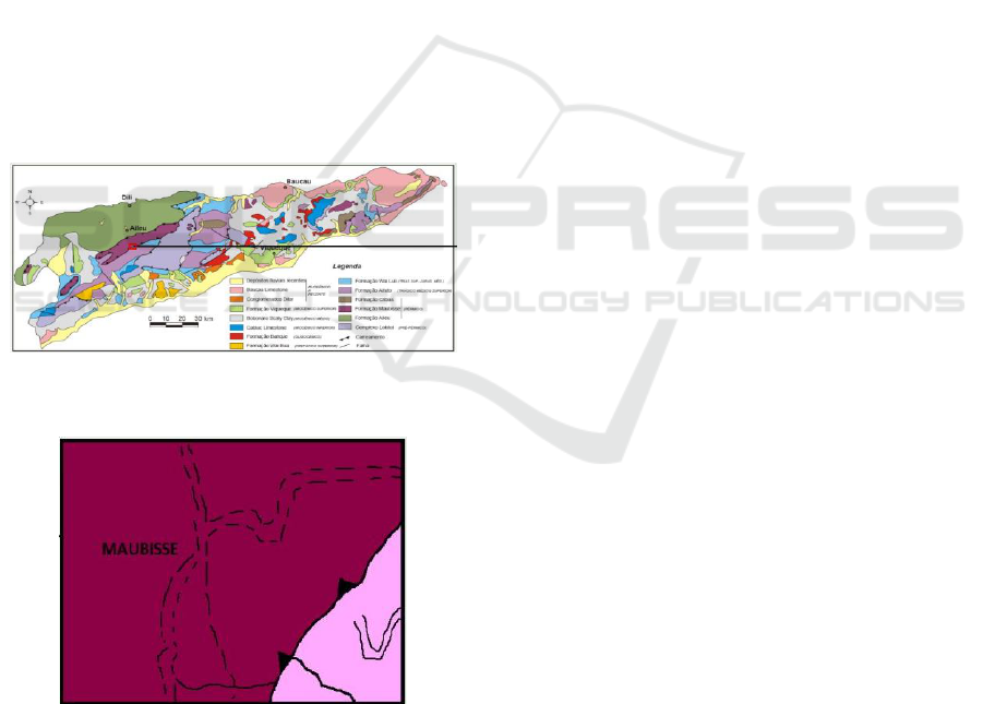
50'17"S. The geological map of Timor Leste and the
outcrop map of study area are shown in Figure 1 and
Figure 2 respectively.
Geotourism is an earth park where its potential is
measured based on geodiversity that has unique
geological characteristics with the beauty values of
natural objects in certain scales and distributions, as
well as integrating other forms of natural scenery and
cultural existence in regional uniqueness (Rachmat,
H., 2017). The geodiversity that has been identified in
the Timor-Leste territory is through regional
geological mapping in the Portuguese period (Audley
Charles, 1968), regional geology map of Dili sheet
(Bachri, S. & Situmorang, R.L.,1994) and also
regional geology map of Baucau sheet (Audley
Charles, 1986). Therefore, the general potential of
geodiversity in Timor-Leste are distributions of
complex rocks including the presence of rare fossils
in sedimentary rocks, physical geological phenomena
(complexity of geological structures) and also
variations of geomorphological landscape such as
islands, lakes, lagoons, hot springs, spring, waterfalls,
beaches, mountains, plateau, plains, rivers and caves.
Figure 1: Geological map of Timor Leste (Carvalho and
Lisboa, 2003).
Figure 2: Outcrop map of study area (Carvalho and Lisboa,
2003).
Based on the regional geology, the studied area is
part of Maubisse and Aitutu Formation with medium
corrugated mountain morphology unit to Structural
Mountain. The geological structures found in the
form of a sliding fault and thrust fault. The Formation
of Aituto, dating from the Triassic mid. - upp,
corresponds to an alternation of thin slates of
limestone, clayey and clayey shales, with
predominance of the carbonated component, whereas
the Wai Luli Formation, Triassics up. to the Middle
Jurassic, is characterized by an increase of the clayey
component. Its potential is linked to the joint
occurrence of more or less marly clays and limestone,
from which the cement industry is interested.
The potential of the Maubisse Formation, also
dating from the Permian, rests on the lower part of the
unit, which is about 400 m thick and where very thick
stands of massive limestone predominate. The upper
part of this Formation consists essentially of rocks of
an eruptive nature, about 500m thick. The limestone
are very poorly affected by metamorphism and
correspond to bio-carcasses of separatists cement,
very rich in fauna, with enhancement for crinoid
remains. They typically have red to pinkish tones, and
lighter tones, cream and gray may also occur. Their
noblest suitability will be for ornamental purposes,
and the use of different aggregates, especially for lime
and cement, in terms of light tones, can not be ruled
out.
Furthermore, geoconservation is the
environmental conservation which consists of the
singularity of geological phenomenon that needs to be
protected through geotourism programs (Crofts, R. &
Gordon, J.E., 2015). The geological conservation area
of Timor-Leste that has been identified from (Haig,
D.W. & McCartain, E., 2010) with the topic of
“Triassic Organic-Cemented Siliceous Agglutinated
Foraminifera from Timor Leste: Conservative
Development in Shallow Marine Environments”
amounts to four (4) areas are as follows; Area of
Tutuala, Area of Iliomar-Aliambata, Area of
Manatuto-Pualaca and Area of Ainaro-Maubisse.
According to Sharples, C., 2002, general reasons for
doing geoconservationare:
1. Geodiversity has a scientific value which is used
for human needs and related ecosystems
2. Characteristics of non-renewable geodiversity
3. Many sensitive geodiversity is easily damaged,
especially the risks caused by various human
activities
4. Providing knowledge information with the
fundamental principles of geoconservation
5. Provide information on geological conservation
status in Timor-Leste
6. Propose to Conservationists to give advice for
decision maker
7. Provide estimation on geoconservation.
ICASESS 2019 - International Conference on Applied Science, Engineering and Social Science
156

Inventory and preliminary identification of
geodiversity data as the first phase in collecting and
improving the quality of information and also the
beginning of a database to make conservation area of
geological diversity. Very important data and a
fundamental basis of information for developing a
geoconservation area based on four points are as
follows (Crofts, R. & Gordon, J.E., 2014):
a. Scientific Value; Characterization of the
geodiversity and geoheritage values based on
their geological processes and history
b. Aesthetic Value; describes the formation of
geoheritage phenomena and various attractions
of geomorphological landscapes
c. Cultural Value; the location of the geoheritage
site is always associated with the culture of the
local community
d. Recreational Value; shows the relationship
between geoheritage sites with various tourism
activities, such as recreation, sports and
adventure.
3 METHODOLOGY
The method that used in this study is descriptive
explorative. Explorative descriptive research is
research that aims to explore extensively about things
or causes that influence the occurrence of something.
The main purpose of this type of research is to
systematically describe the facts and characteristics
of objects or subjects that are precisely examined,
related to this research, the situation that will be seen
is the potential of geotourism in Suco Edi, Maubisse,
Ainaro, Timor-Leste.
This study applies two (2) stages approaches i.e.
Literature Review and Field Observation. The aim of
reviewing existing literatures are to have a prior
understanding and accumulation stage of references
needed from various sources, especially about
geotourism and geology of Timor-Leste while Filed
Observation or Field Work is the stage of collecting
all pertinent geotourism objects in identifying the
general potential of geodiversity. There is one (1)
considered method applying in this research. It is
qualitative method such as "GIS Survey, Descriptive
and Interview to the community”. Lastly, this
database is used and analyzed using the Kubalíková
parameter 2013, to obtain the results of the feasibility
of the geotourism percentage.
4 RESULTS AND DISCUSSIONS
We have discovered three types of tourism resources
that are potential for geotourism: geological tourism,
geomorphological tourism and river tourism – all
located in nine sites (two geomorphosites and seven
geosites).
4.1 Pousada Geomorfosite
Pousada is located in Maubisse village in (1302 - m,
08 50’ 27,5’’-125 36’ 07,6”) perched on a lookout just
off the main road near the bend. It’s a Guesthouse set
in amazing gardens within old stone walls
(Portuguese colonial era), Considering the Hill top
location offers expansive views and history behind
this beautiful old place, the community, traditional
and culture in the surrounding area and based on
feasibility study, we consider it as a potential
geomorphosite for geotourism (89%).
4.2 Erus Manu Waterfall
It is located in Edi Village (1300 m, 08°51'41"0 S-
125°35'50" E). Erus Manu waterfall is the body of Edi
Erus rivers, water's steep fall from 4 meters height
over a rocky ledge of Limestone that fall downward
in to pool below with depth of 2 meters. The type of
this waterfall is horsetails. Horsetail is a type
waterfall in which water flows over a broad ledge,
usually an overhanging one, into a pool by keeping
contact with the underlying rock during its descent. In
fact, the local people use this place for swimming
recreation because the water is clear, clean and fresh.
The average geosite potential is 64% for Geotourism.
4.3 Haut Doner Waterfall
Haut Doner is the water's steep fall from 1-meter
height over of massive boulders of Limestone and
surrounded by red limestone outcrop that descending
in to pool below where the water is very clean, clear
and fresh with depth about 0.85 meter as the body of
Edi Erus river. It’s type of FAN waterfall that is a
steep angled cascade that fans out from a narrow
width at the top to a larger base at the bottom. Most
fans are also horsetails in that are maintain contact
with undering rock during their descent. It’s located
in Edi Village (1201 m, 08°51'42"5 S
‑ 125°37'40"8"S) The average geosite potential is
64% for Geotourism.
4.4 Ermanfoli Waterfall
Ermanfoli Waterfall is very clear clean and cold and
water's steep fall from 15 meters height over a
Study for Development of Geotourism Potential in Edi Village Timor Leste
157

bedrock of Clastic limestone (Maubisse Formation)
that falls downward without making contact with the
underlying rock in to pool below with depth of 2
meters. The waterfall has enough space between the
water and the rock that you can walk behind it. This
type of waterfall is known as plunge waterfall. The
Ermanfoli has a cave behind the waterfall that makes
it unique in and has historical story in it, where in the
conflicts times the Portuguese colonization and of the
Indonesian occupation the local people escape and
evacuate into the cave. The average geosite potential
is 59% for Geotourism. It is located Edi Village (1197
m, 08°51'42"2 S ‑ 125°37'44"0"S).
4.5 Ersulihatmau Waterfall
It’s water steeps fall from 1-meter height over of
massive boulders of limestone that descending in to
pool below where the water is very clean, clear and
fresh with depth about 0.73 meter as the body of Edi
Erus river. It’s type of fan waterfall that is a steep
angle cascaded that fans out from a narrow width at
the top to a larger base at the bottom Most fans are
also horsetails in that they maintain contact with
underlying rock during their descent. It is located in
Edi Village (1175m, 08°51'42"5 S‑ 125°37'40"8"S).
The average geosite potential is 64% for Geotourism.
4.6 Ermihis Waterfall
Its water steeps fall from 25 meters height over of
limestone (Maubisse Formation) that descending in to
pool below where the water is very clean, clear and
fresh with depth about 0.1 meter. It is type of FAN
waterfall that is a steepagled cascade that fans out
from a narrow width at the top to a larger base at the
bottom maintain contact with bedrock during their
fall downward. It’s located in Edi village (1165m, 08
51’ 45,9”125 37’ 57,4”). The average geosite
potential is 64% for Geotourism.
4.7 Erkuira Waterfall
Erkuira block waterfall is a type of "ledge" waterfall.
In a block waterfall, water falls from a wide river or
stream, and the fall is typically wider than it is tall.
The water drops over the vertical cliff with 5 meters
height over a rocky ledge of clastic limestone that fall
downward into the pool bellow with depth of 2
meters. It is located in Edi Village (1160 m,
08’’51’51,2”- 125’’38’03,7”). The average geosite
potential is 59%.
4.8 Debu Waterfall
Debu waterfall It is located in Edi Village (1160m,
08’51’58,5”-125 38’ 08,4”). The average geosite
potential is 59% for Geotourism. It is Slide waterfalls
can be considered a sub-type of horsetail. The water
glides down a relatively low angle slope, maintaining
continuous contact with bedrock of layered clastic
limestone. However, is that contact is constant
because of the shallow slope of the rock in slide
waterfalls (Height 11m, depth 2m).
4.9 Edi Simerah Waterfall
This geomorphosite is located in Edi Simerah Village
(2002m 08 51’ 31,3”-125 37’ 43,5”). The
geomorphosite of Edi Simerah shows landforms that
have acquired a scientific, cultural or historical,
aesthetic and/or social/economic. In the hill of Edi
Simerah there are complete component for a
geomorphosite. Raimerah Waterfall (Fan waterfall),
Traditional house of Edi Raimerah, small chapel
made of woods and Hill top location offers expansive
views of structural mountain landscape with average
potential to be develop for geotouristic destination
makes up to 69%.
A geotouristic tracking route map has been
designed. It is start from Pousada to Edi Village. It
normally takes about 1 hour by motorbike and car.
The road to Edi village is adventurous and the
surrounding view is amazing and in the middle of the
trip it’s better to take a stop in Ule Lefa strawberry
garden. Ule Lefa is well known as a ecotourism site
for strawberry farming (1411m, 08 50’30,3’ S -
125’37’ 14,5’’).
5 CONCLUSIONS
Edi Village has significant potential to be developed
as one of the geotourism destination in Maubisse,
Ainaro, Timor-Leste. The geotourism potential of
Suco Edi, we have discovered three types of tourism
resources: geological tourism, geomorphological
tourism and river tourism all located in nine sites (two
geomorphosites and seven geosites). The average
results of the feasibility study of the geotourism
potential in each of these sites are: Pousada
Geomorphosite 89%; Erus Manu Waterfall 64%;
Haut Doner Waterfall 64%; Ermanfoli Waterfall
59%; Er Sulihat Mau waterfall 64%; Er Mihis
Waterfall 64%; Er Kuira Waterfall 59%; Debu
Waterfall 59%; and Edi Simerah Geomorphosite
69%. Considering all the aspects above, which were
based on the quantification and comparison of the
various wonders between nature and geological
ICASESS 2019 - International Conference on Applied Science, Engineering and Social Science
158

processes that turns possible the implementation of
geotourism object, it shows that Suco Edi has tourism
resources that are suitable to be developed into
geotourism sites with an overall average feasibility
value of 65.66%. Recognizing that Edi is a rural
village, the development of geotourism in the area
would even be beneficial for a local and sustainable
economic development. Hence, infrastructure
development would be required as well as legislative
protection in order to use the geotourism resources of
the area to improve the living conditions of the local
community and to promote this village (and, thus,
Timor-Leste) in a wider scale. Community and local
leaders of Edi Village need protect those sites and
develop as much as possible and propose it to the
government for the further study and support
geotourism development in the potential area. Further
survey research is needed which is more focusing in
to the detailed on the geological condition and
process of the area. This place is recommended for
geologist students for the field study due to the
existence of geological essential features such as
beautiful and complex structures and unique lithology
that is Permian Maubisse formation. Highly
recommended to adventurer, traveler and nature lover
to explore this hidden beautiful remote Village of Edi
Maubisse.
REFERENCES
Audley-Charles, M. G., 1986, Rates of Neogen and
Quaternary tectonic movements in the Southern Banda
Arc based on micropaleontology. Journal of the
Geological Society, 143 (1):161-175.
Bachri, S. & Situmorang, R. L., (1994), Peta Geologi
Lembar Dili, Timor-Timur, Skala 1:250.000,
Belazario G. F. M. de Araujo., Emeliano M. G. de Oliveira
(Oct, 2018) Descriptive and Quantitative Study for
Development of Geotourism Potential in Edi Village,
Maubisse, Ainaro, Timor-Leste. Poster session
presented at the 4th International Conference: Dili,
Timor-Leste.
Carvalho, J. M., & Lisboa, J. V. (2003). Breve panorâmica
sobre os recursos geológicos não metálicos de Timor
Leste. In VI Congresso Nacional de Geologia, 4 a 6 de
Junho de 2003.
Crofts R. and Gordon J. E. (2015) Geoconservation in
protected areas. Protected area governance and
management. ANU Press, Canberra, pages 531–568.
Crofts R, Gordon JE (2014) Geoheritage conservation in
protected areas.
Haig, D., & Mccartain, E. (2010). Triassic organic-
cemented siliceous agglutinated foraminifera from
Timor Leste: conservative development in shallow-
marine environments. Journal of Foraminiferal
Research, 40(4), 366-392.
Hose TA (1995) Selling the story of britain’s stone,
environmental interpretation, 10-2. Disponible on line:
http://ojs.zrc-sazu.si/ags/article/view/1315/1079, pages
16–17.
Kubalíková, L., 2013, Geomorphosite assessment for
geotourism purposes, Czech Journal of Tourism
2(2):80-104.
Newsome D, Dowling RK (2010) Geotourism: the tourism
of geology and landscape. Good fellow Publishers,
Oxford.
Sharples, C. 2002, Concepts and principles of
geoconservation. Tasmanian Parks & Wildlife Service
website. http://www.dpiw.tas.gov.Au/inter.Nfs/
Attachments/SJON-57W3YM/$FILE/
geoconservation.pdf
Study for Development of Geotourism Potential in Edi Village Timor Leste
159
