
Multi-agent Systems in Remote Sensing Image Analysis
Peter Hofmann
Institute of Applied Informatics, Deggendorf Institute of Technology, Technology Campus Freyung, Grafenauer Str. 22,
D-94078 Freyung, Germany
Interfaculty Department of Geoinformatics, Z_GIS, Schillerstr. 30, A-5020 Salzburg, Austria
Keywords: Multi-agent Systems, Remote Sensing, Object based and Agent based Image Analysis.
Abstract: With remote sensing data and methods we gain deeper insight in many processes at the Earth’s surface. Thus,
they are a valuable data source to gather geo-information of almost any kind. While the progress of remote
sensing technology continues, the amount of available remote sensing data increases. Hence, besides effective
strategies for data mining and image data retrieval, reliable and efficient methods of image analysis with a
high degree of automation are needed in order to extract the information hidden in remote sensing data. Due
to the complex nature of remote sensing data, recent methods of computer vision and image analysis do not
allow a fully automatic and highly reliable analysis of remote sensing data, yet. Most of these methods are
rather semi-automatic with a varying degree of automation depending on the data quality, the complexity of
the image content and the information to be extracted. Thus, visual image interpretation in many cases is still
seen as the most appropriate method to gather (geo-) information from remote sensing data. To increase the
degree of automation, the application of multi-agent systems in remote sensing image analysis is recently
under research. The paper present summarizes recent approaches and outlines their potentials.
1 INTRODUCTION
Remote sensing data is a valuable data source for a
variety of disciplines related to Earth’s surface and
the environment. With it, fast and even ad hoc maps
can be produced (e.g. for hazard management) or
long-term processes and their footprints can be
monitored (e.g. the ongoing deforestation, the global
urbanisation or the desertification). Further, archives
of remote sensing data are growing continuously (Ma
et al. 2015). In this context, terms such as “digital
Earth” (Boulton 2018) or “Big Earth data” (Guo
2017) evolved recently. However, in comparison to
other types of image data, particularly remote sensing
data are very complex to handle due to their complex
contents and characteristics. Thus, in many cases,
human image interpretation is understood as the most
reliable method to extract geo-information from
remote sensing data. However, manual mapping from
remote sensing data needs a lot of experience in
image interpretation and is very labour intensive. The
results of manual image interpretation are subjective
and of limited reproducibility. However, automatic
methods producing comparable results as human
image interpretation does, are not in sight yet.
Recent automatic methods must compromise
between the degree of automation and the accuracy
and reliability of the results. The higher the level of
detail and accuracy, the more individual imaging
situations must be considered. This, in turn, increases
the complexity of the rule sets and algorithms applied,
which simultaneously reduces their robustness and
general applicability. This dilemma has been asserted
already by Hofmann et al. (2011), Rokitnicki-Wojcik
et al. (2011), Kohli et al. (2013) and Anders et al.
(2015). Current strategies to increase the degree of
automation follow a design pattern approach as it is
known from engineering: By developing so-called
“master rule sets” for similar problems individual
results are produced by deviating a specialized
solution for individual images (Tiede et al. 2010).
However, depending on the complexity of the
mapping task and the data used, the human effort with
these approaches is still relatively high. Thus, to
efficiently exploit the ever-growing remote sensing
and geo-data archives the degree of automation in
image analysis must increase. That is, automatic
remote sensing image analysis must become more
flexible and robust against perturbations, similar the
way human visual image interpretation is already.
178
Hofmann, P.
Multi-agent Systems in Remote Sensing Image Analysis.
DOI: 10.5220/0007381201780185
In Proceedings of the 11th International Conference on Agents and Artificial Intelligence (ICAART 2019), pages 178-185
ISBN: 978-989-758-350-6
Copyright
c
2019 by SCITEPRESS – Science and Technology Publications, Lda. All rights reserved

Research in remote sensing image analysis
traditionally investigates the potential of AI methods
– mainly those of computer vision. Investigating
agent-based methods could foster the degree of
automation and reliability in this particular field,
since automating the analysis of remote sensing data
is less a computer vision problem but rather a problem
of optimally apply, network and parameterize known
methods of computer vision and image processing. A
key role in this context plays knowledge and
knowledge description: while for visual image
interpretation so-called “interpretation keys” are
used, which verbally describe how the objects of
interest look like, in computer based image analysis
domain specific knowledge, knowledge about the
data’s genesis and knowledge about sensible methods
to process the data is incorporated the one or other
way (e.g. Belgiu et al., 2014; Arvor et al. 2013). Once
made explicit, e.g. as a formal ontology, this
knowledge can be used as rules, rule sets and/or
algorithms for image analysis. Nevertheless,
knowledge often is also incorporated implicit, too,
e.g. by Artificial Neural Networks (ANNs) or by
other sample based classification methods.
Independent of its representation, this knowledge is
often distinguished into: declarative knowledge
which describes the characteristics of the expected
object-classes and procedural knowledge which
describes the necessary image processing methods.
Accordingly, recent agent-based methods of image
analysis can be roughly separated into two types:
methods which operate at procedural level and try to
adapt existing methods similar to the design pattern
approach and methods which operate at descriptive
level and try to optimize the objects’ representation in
the image, that is, their delineation. However,
applying agent-based methods for remote sensing
image analysis is still at its beginning and has a lot of
potential which goes beyond the improvement of
image analysis. The paper present tries to outline the
state of the art in this particular field and its potential
for future applications.
2 REMOTE SENSING IMAGE
ANALYSIS
While visual image interpretation of remote sensing
data is still a common way to gather information from
remote sensing images, at least since the 1970ies
there were always attempts to automate image
analysis (e.g. Colwell, 1968). Until the millennium
Landsat images with a resolution of 30m were the
dominating set of optical Earth Observation (EO)
data. Thus, for the most applications it was sufficient
to analyse images based on the radiometry and its
statistics stored in single pixels. Before the
millennium, higher spatial resolution could only be
achieved with airborne data, but from 2000 onwards
the resolution of space borne data increased from 1m
to 0.3m in 2010. Although with the new sensors more
details were visually recognizable, automated image
analysis of this kind of data became rather complex.
It soon turned out that new analysis methods for Very
High Resolution (VHR) remote sensing data were
necessary. Thus, methods which operate on image
segments (Object-Based Image Analysis, OBIA)
instead of pixels and which incorporate formal expert
knowledge became more and more popular (Benz et
al. 2004; Blaschke 2010). Blaschke et al. (2014) were
even speaking of a paradigm change in remote
sensing image analysis.
In order to reuse once developed methods,
workflows of individual image analysis can be noted,
stored and re-applied the one or other way (often
named rule sets). For this purpose, Domain-Specific
Languages (DSL) comprising all necessary domain
specific terms, rules and knowledge descriptions were
developed (e.g. Schmidt et al., 2007). With these
DSLs it is possible to develop individual solutions
according to the design-pattern approach.
2.1 Pixel-based Image Analysis
In remote sensing many methods of pixel-based
image analysis are applied. Some of them are specific
from the remote sensing domain, such as the
calculation of the Normalized Differential Vegetation
Index (NDVI) and ortho-rectification, others are
rather general, such as texture analysis based on the
Grey Level Co-Occurrence Matrix (GLCM). For
analysis purposes each pixel of an image is assigned
to a meaningful real-world class, that is, pixels are
classified by an arbitrary supervised or unsupervised
classification method. Besides the original grey
values, derivative pixel values such as the NDVI or
GLCM values can extend the feature space for the
classifier. The list of classification algorithms
meanwhile ranges from simple threshold-based
classifiers, clustering algorithms and Support Vector
Machines (SVMs) to Fuzzy Classifiers, Bayesian
Networks and ANNs.
Nevertheless, for a successful application of all
these methods, a thorough knowledge of image
processing and remote sensing is essential. That is,
pixel-based image analysis usually consists of an
(iterative) sequence of image processing methods
Multi-agent Systems in Remote Sensing Image Analysis
179

which needs to be adapted according to the individual
imaging situation (Lillesand et al. 2014; Canty 2014).
2.2 Object-based Image Analysis
In OBIA a (hierarchical) net of so-called image
objects is generated by arbitrary image
segmentations. With these image objects a lot of
disadvantages which go ahead with the pixel-based
approach for VHR remote sensing data vanish, such
as the decreased signal-to-noise ratio in VHR data
(the so-called “salt-and-pepper effect”; Blaschke and
Strobl, 2001). A further recognized advantage of
OBIA is its affinity to Geographic Information
Systems (GIS): image objects aka image segments are
very similar to polygons, which means many GIS-
typical (polygon) operations can be used similarly
with image objects. Additionally, GIS-polygons can
be used for image segmentation and their attributes
can be used in OBIA to support the classification.
Another advantage is the possibility to work with
object hierarchies: Image objects at different
segmentation levels represent pairwise disjoint
objects of different size (i.e. at different scale). This
approach reflects the multi-scale methods of
landscape analysis and allows to develop semantic-
rich rule sets for image analysis (Burnett and
Blaschke, 2003; Stoter et al., 2011).
Further, the usable feature space in OBIA is of
very high dimension: it comprises the objects’
physical properties (colour, form and texture) and
their semantic properties (hierarchical and spatial
relations to other objects with certain characteristics
and/or class memberships). Nevertheless, similar to
pixel-based image analysis the whole process of
analysing a single image can be very complex.
2.3 Knowledge Representation in
Image Analysis
Pixel-based and object-based image analysis
incorporate explicit and/or implicit knowledge for
object identification. The knowledge used can be
distinguished into two principle domains
(Bovenkamp et al. 2004): Procedural knowledge,
describes all image processing methods and
parameterisations necessary to extract all intended
object categories from the image data. If procedural
knowledge is represented explicitly, it is described as
so-called task ontology. Declarative knowledge
describes the shape of the intended object categories,
that is, how these classes appear in the image data
similar to an image interpretation key but with
measureable feature values and constraints. It can
then be represented explicitly by a so-called
descriptive ontology and used to automatically infer
an objects class membership. Both knowledge
domains are interlinked, as the following example
demonstrates: vegetation can be easily identified in
remote sensing data using the NDVI. The NDVI is
commonly calculated by:
𝑁𝐷𝑉𝐼 =
𝑁𝐼𝑅 − 𝑅𝑒𝑑
𝑁𝐼𝑅 + 𝑅𝑒𝑑
(1)
Whereas NIR represents the grey value in the Near
Infrared band and Red the grey value in the Red band
of a sensor. A value of 0.0 < NDVI ≤ 1.0 indicates
“vegetation”, a value of -1.0 < NDVI < 0.0 indicates
“no vegetation”. The declarative knowledge which
describes “vegetation” must represent this typical
shape of vegetation by an appropriate (classification)
rule, e.g.:
Class vegetation {
…
0.0 < NDVI(x) < 1.0;
…
};
With x representing any individual pixel or
segment of an image. The procedural knowledge for
the class “vegetation” must include a description of
how the NDVI is calculated (see eq. 1) with the data
currently used, e.g.:
If sensor = “Landsat 8” THEN
NDVI(x) = band 4(x) – band 3(x) /
band 4(x) + band 3(x);
Endif.
The way how procedural and declarative
knowledge are represented can be manifold. In the
example given, it is noted explicitly and crisp. But it
could be represented implicit and/or fuzzy, too. By
noting this knowledge explicitly, e.g. as a formal
ontology, it can be reused and/or adapted easily.
However, implicit representations (e.g. as trained
classifier or as a Convolutional Neural Network,
CNN) are possible, too, but have a black-box
character and are therefore less comprehensible and
less adaptable.
3 AGENT-BASED METHODS IN
IMAGE ANALYSIS
Applying agent-based methods in image analysis is
relatively new. According to Rosin and Rana (2004)
many methods of computer vision which claim to be
ICAART 2019 - 11th International Conference on Agents and Artificial Intelligence
180

agent-based are not. They often lack basic elements
of agent-based computing, such as situation
awareness, autonomy of individual agents, goal-
orientation of agents, cooperation and
communication of agents and many more. However,
some recent agent-based methods of image analysis
follow the agent-based paradigm (Jennings 1999;
Wooldridge 1998). Especially in remote sensing,
agent-based approaches for image analysis can be
separated into two major types as outlined in section
1: procedural level approaches and declarative level
approaches.
3.1 Approaches Acting at Procedural
Level
In the very beginning of agent-based image analysis,
Multi Agent Systems (MAS) were mainly used to
parallelize necessary image processing tasks and to
improve their performance (Lueckenhaus and
Eckstein, 1997). Besides the potential for
parallelisation of image analysis Lueckenhaus and
Eckstein (1997) outlined the ability of software
agents to be aware about their environment, to be able
to cooperate, to be able to learn and plan, that is, to
react flexible on a varying environment and to be
goal-oriented. Thus, their agent-based system for
image analysis went beyond a simple parallelisation
of image analysis tasks. It rather enabled the MAS to
autonomously organize all necessary image analysis
procedures in order to optimize the results and the
operating costs.
Zhou et al. (2004) followed this approach but
aimed at an increase of performance and robustness
of computer vision systems for real-time applications
in dynamic environments. They organising the
underlying MAS architecture like a Resource
Management (RM) system, wherein software agents
are negotiating processing priorities and resources
according to the current situation of the system and its
environment. Their system has been tested among
others in remote sensing to reduce and optimize the
downlink of satellites.
Heutte, et al. (2004) introduced a similar system
for handwritten text recognition. But in contrast to the
system of Zhou et al. (2004) this system incorporates
knowledge at different levels. For each knowledge
level an according group of specialised software
agents was created, each of which being responsible
for a dedicated task (e.g. for letter recognition or
feature extraction).
Cellular automata (Liu and Tang, 1999) were
another approach, primarily for image segmentation.
Pixels aka cells or agents which meet certain
homogeneity criteria were labelled and aggregated to
image segments.
3.2 Approaches Acting at Declarative
Level
Bovenkamp et al. (2004) introduced a MAS for
segmenting Intra Vascular Ultra Sound (IVUS)
images. By describing and applying procedural
knowledge and declarative knowledge
simultaneously. In their approach five different
specialized types of segmentation agents, each of
which responsible for the delineation of different
object classes, plus a control instance responsible to
dissolve conflicts were implemented and connected
to a MAS. The MAS incorporates global constraints,
contextual knowledge and local image information.
To the knowledge of the author Samadzadegan et
al. (2010) were the first who applied agent-based
methods in the remote sensing domain. Similar to the
approach of Bovenkamp et al. (2004) they developed
a MAS which consists of two groups of software
agents to classify pixels in a Digital Elevation Model
(DEM). The DEM has been deviated from a Light
Detection And Ranging (LiDAR) point cloud and is
represented as a 2D grid of cells. Within the groups,
agents can apply dedicated procedures of image
processing and reasoning in order to extract buildings
and trees from the data. Conflicts occurring during the
detection process are solved by a “coordinator agent”.
In both approaches, declarative knowledge has been
applied for reasoning the class membership of each
segment.
Mahmoudi et al. (2013 and 2014) were the first
who combined agent-based methods with OBIA
methods. For the purpose of mapping urban structures
in WorldView-2 satellite data, they segmented the
image using a global segmentation algorithm, here:
the Multi-Resolution Segmentation (MRS) according
to Baatz and Schäpe (2000), and then applied a MAS
to assign the segments to classes. That is, reasoning
agents used declarative knowledge for assigning each
segment to according classes. However, by resigning
agents being responsible for the segmentation or other
sensible image processing operations, that is, agents
acting at procedural level, this approach is relatively
static.
Borna et al. (2014, 2015 and 2016) introduced an
agent-based system which allows image objects in
OBIA to dynamically change their shape depending
on each individuals’ appearance and spatial context
(“elastic boundary”). However, their approach is very
similar to that of Samadzadegan et al. (2010) and
Bovenkamp et al. (2004), except that it uses image
Multi-agent Systems in Remote Sensing Image Analysis
181
objects represented as GIS vector objects instead of
pixels. The dynamics of the “elastic boundaries” are
rather driven by general abilities each “vector-agent”
(VA) has, than by the class assignment or
intermediate classification results. That is, declarative
knowledge has no impact on the VAs’ behaviour.
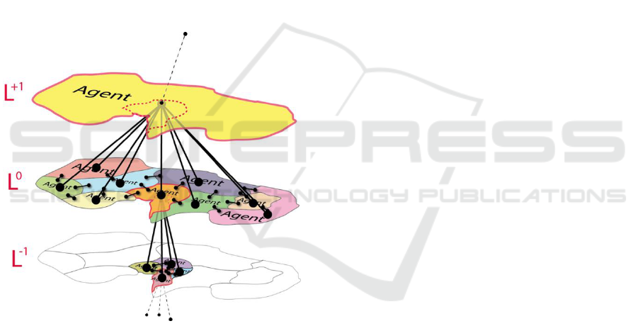
At the same time Hofmann et al. (2014, 2015 and
2016) presented a conceptual framework for Agent
Based Image Analysis (ABIA) of remote sensing
data. Main focus of their research was to mimic a
human operator who would either adjust an existing
rule set (design pattern approach) or manually correct
the object delineation aka image segmentation. They
developed two types of independent MAS: (1) a MAS
consisting of so-called Rule Set Adaptation Agents
(RSAAs) and one or more Control Agents (CAs) to
autonomously adapt given rule sets, and (2) a MAS
of hierarchically organized Image Object Agents
(IOAs) which can autonomously adapt their segment-
boundaries (Fig. 1).
Figure 1: Hierarchy of Image Object Agents (IOAs).
Parts of the latter approach were further extended
in (Hofmann, 2017) by a fuzzy Belief Desire
Intension (fBDI) model which allows each IOA to
decide in a fuzzy manner which is its next intended
action.
Troya-Galvis, et al. (2016, 2018a and 2018b)
investigated an approach to optimise image segments
by means of controlling their classification quality
through software agents. Similar to the approach of
VAs in Borna et al. (2014, 2015 and 2016) and of
IOAs in Hofmann et al. (2014, 2015 and 2016) this
approach incorporates declarative knowledge to
trigger software agents in order to improve each
individual segment. After an initial segmentation,
software agents can negotiate ambiguously classified
or unclassified pixels in order to improve the
segments’ classification quality. To avoid deadlocks,
the segment-optimisation is applied cascaded and
starts randomly. A control instance evaluates the
achieved quality and triggers potential further
segment adaptations.
4 AGENT-BASED MODELLING
AND AGENT-BASED IMAGE
ANALYSIS
Agent Based Models (ABMs) and recent agent-based
image analysis of remote sensing data are relatives.
ABMs have a long tradition in GISciences and other
disciplines to simulate complex processes. First
ABMs were applied in the late 1980ies and early
1990ies, e.g. Holland and Miller (1991) in economics
or Huston, et al. (1988) in ecology. Major purpose of
ABMs in GISciences is to simulate and explain
complex spatial processes, that is, (1) to understand
spatial patterns and how they are generated by
interacting individuals and (2) to understand spatial
and temporal interrelationships between individuals
and their environment. All ABMs have in common to
simulate the (spatial) behaviour of individual agents
and the emerging spatial patterns based on relatively
simple rules of (inter-) action with or within their
environment. In doing so, it does not matter whether
individual agents are spatially represented by simple
pixels aka cells, or by GIS vector objects, that is,
points, lines or polygons. Especially vector objects
can be of arbitrary geometric (and dynamic)
complexity; e.g. VecGCA, introduced by Marceau
and Moreno (2008), allows agents being represented
as polygons and to change their shape during
simulation very similar to the approach of Borna et al.
(2014, 2015 and 2016). However, in almost all cases
remote sensing data has been used to validate the
developed ABMs by comparing the observable
patterns in remote sensing data with those produced
by the ABMs (Adhikari and Southworth, 2012; Sohl
and Sleeter, 2012; Megahed et al., 2015).
4.1 Similarities between ABM and
Agent-based Image Analysis
Comparing the concepts of spatially acting agents in
the remote sensing domain with the principles of
ABMs, in both domains individual agents operate
dynamically in space. However, while ABM agents
ICAART 2019 - 11th International Conference on Agents and Artificial Intelligence
182

generate spatial patterns, their counterparts in image
analysis try to optimize the representation of real-
world-objects by image segments. In both domains
their behaviour is based on relatively simple rules
noted in a Belief Desire Intention (BDI) model and
the agents’ perception of the environment. Since in
both domains software agents represent spatial
entities aka real-world-objects, the agents’ BDI
model depends on the real-world-objects they
represent: The procedural knowledge for delineating
“trees” in an image is different to that for “buildings”.
The same holds for their declarative knowledge to
reason their class assignments. In a sensible ABM
“tree”-agents certainly behave different than
“building”-agents, which means their roles and
abilities in an ABM are different. That is, the same
real-world-objects are represented by two different
kinds of agents, which exist and act in different
environments, namely an image of the real world
consisting of numerical values (remote sensing) and
an abstract geometric model of the real world (ABM).
In both representations, their behaviour is determined
by the ontology of the real-world-objects they
represent but it depends on the environment they act
in.
4.2 Differences between ABM and
Agent-based Image Analysis
The very difference between ABMs and agent-based
image analysis concepts is the absence of robot-like
agents in ABMs which are able to autonomously
apply procedural knowledge in terms of selecting,
combining or manipulating image processing
methods.
Another difference is the agents’ goals: in agent-
based image analysis agents intend to achieve a best
possible delineation of the imaged real world objects
according to the declarative knowledge by applying
procedural knowledge. The goal of agents in ABMs
instead is to achieve an equilibrium or a Pareto
optimality in the simulated (real-)world they are
acting in.
A further difference is the absence of control
instances in ABMs. In agent-based image analysis
they are necessary to evaluate (intermediate) results
during processing and to trigger the behaviour of
individual agents. In ABMs such a mechanism is not
necessary.
Further, in contrast to agents in ABMs, VAs or
IOAs can change their class membership (and
consequently change their behaviour): During the
adaptation process it might happen, that individual
IOAs or VAs fulfil the declarative criteria of multiple
real-world-classes (simultaneously). ABM agents in
principle only change their class or role explicitly by
design.
Last but not least ambiguity in agent-based image
analysis must be taken into account the one or other
way. Even classification results can be ambiguous. In
ABMs ambiguity only matters for the perception of
the environment, that is, an agent’s role in an ABM is
unambiguous.
5 CONCLUSIONS AND
OUTLOOK
The increasing growth of remote sensing data
archives demands new methods of automatic, reliable
and autonomous extraction of geo-information from
remote sensing data. Recent methods are either
lacking a high degree of automation or a high degree
of reliability. Although recent methods of computer
vision, such as CNNs are meanwhile very successful
in diverse imaging domains, in the remote sensing
domain they are not more suitable than other
established methods.
Although not exhaustively researched yet, multi-
agent systems for remote sensing image analysis have
the potential to increase the degree of automation and
reliability of remote sensing image analysis.
Especially their ability to react flexible and robust on
changing environmental situations (slightly changing
imaging conditions, atmospherical impact, slightly
changing image quality, seasonal impacts, etc.) seems
to be promising. Nevertheless, research results which
could confirm the advantage of agent-based image
analysis methods especially in the context of
analysing large archives are still missing. Troya-
Galvis, et al. (2016, 2018a and 2018b) observed in
their investigations slightly improved classification
results compared to a CNN-based and a hybrid
segmentation-classification approach called
“Spectral-Spatial Classification” (SSC). Borna et al.
(2014, 2015 and 2016) and Hofmann et al. (2014,
2015 and 2016) could just demonstrate the feasibility
of their approaches, yet, but validation results, or
results proofing the ability to reliably analyse large
archives of remote sensing data are still missing. Last
but not least enabling image analysis agents to learn
(Biswas et al. 2005), especially for design pattern
approaches, is an interesting aspect for further
research. In this context the incorporation of implicit
knowledge, in agent-based image analysis (e.g. by
using ANNs) has not been investigated, yet.
Multi-agent Systems in Remote Sensing Image Analysis
183

From a geo-scientist’s point of view, the similarity
of ABMs and the concept of VAs or IOAs is a further
interesting aspect: by coupling individual but
corresponding ABM agents and VAs/IOAs, they
could facilitate a quasi in-situ validation of an ABM
simulation unlike the post-simulation validation, as it
is still done today. The latter also has a high potential
to improve our understanding of the environment and
the Earth system, especially in conjunction with time
series of remote sensing data. A further interesting
aspect of coupling agent-based image analysis with
ABMs is their consideration of scale: here
hierarchically organized VAs/IOAs could support the
validation of aggregation and emergence processes of
individual agents in ABMs, such as urbanisation (de-
)forestation or the evolvement of swarms.
REFERENCES
Adhikari, S., Southworth, J., 2012. Simulating Forest Cover
Changes of Bannerghatta National Park Based on a CA-
Markov Model: A Remote Sensing Approach. In:
Remote Sensing 4 (10): 3215–43.
Anders, N. S., Seijmonsbergen, A. C., Bouten W. 2015.
Rule Set Transferability for Object-Based Feature
Extraction: An Example for Cirque Mapping. In:
Photogrammetric Engineering & Remote Sensing 81
(6): 507–14.
Arvor, D., Durieux, L., Andrés, S., Laporte, M.-A., 2013.
Advances in Geographic Object-Based Image Analysis
with Ontologies: A Review of Main Contributions and
Limitations from a Remote Sensing Perspective. In:
ISPRS Journal of Photogrammetry and Remote Sensing
82: 125–37.
Baatz, M., Schäpe, A., 2000. Multiresolution
Segmentation: An Optimization Approach for High
Quality Multi-Scale Image Segmentation. In J. Strobl,
T. Blaschke, G. Griesebner (Eds.): Angewandte
Geographische Informations-Verarbeitung XII,
Wichmann Verlag, Karlsruhe (2000), pp. 12-23.
Belgiu, M., Hofer B., Hofmann, P., 2014. Coupling
Formalized Knowledge Bases with Object-Based
Image Analysis. In: Remote Sensing Letters 5 (6): 530–
38.
Benz, U. C., Hofmann, P., Willhauck, G., Lingenfelder, I.,
Heynen, M., 2004. Multi-Resolution, Object-Oriented
Fuzzy Analysis of Remote Sensing Data for GIS-Ready
Information. In: ISPRS Journal of Photogrammetry and
Remote Sensing 58 (3–4): 239–58.
Biswas, G., Leelawong, K., Schwartz, D., Vye, N., 2005.
Learning by Teaching: A New Agent Paradigm for
Educational Software.” In: Applied Artificial
Intelligence 19 (3–4): 363–92.
Blaschke, T., Strobl, J., 2001. What’s Wrong with
Pixels?: Some Recent Developments Interfacing
Remote Sensing and GIS. In: GeoBIT, 6 (6): 12–17.
Blaschke, T. 2010. Object Based Image Analysis for
Remote Sensing. In: ISPRS Journal of Photogrammetry
and Remote Sensing 65 (1): 2–16.
Blaschke, T., Hay, G. J., Kelly, M., Lang, S., Hofmann, P.,
Addink, E., Feitosa, R. Q., Van der Meer, F., Van der
Werff, H., van Coillie, F., 2014. Geographic Object-
Based Image Analysis–towards a New Paradigm. In:
ISPRS Journal of Photogrammetry and Remote Sensing
87: 180–91.
Borna, K., Moore, A. B., Sirguey, P., 2014. Towards a
Vector Agent Modelling Approach for Remote Sensing
Image Classification. In: Journal of Spatial Science 59
(2): 283–96.
Borna, K., Moore, A. B., Sirguey, P., 2016. An Intelligent
Geospatial Processing Unit for Image Classification
Based on Geographic Vector Agents (GVAs). In:
Transactions in GIS 20 (3): 368–81.
Borna, K., Sirguey, P., Moore, A. B., 2015. An Intelligent
Vector Agent Processing Unit for Geographic Object-
Based Image Analysis. In: Geoscience and Remote
Sensing Symposium (IGARSS), 2015 IEEE
International, 3053–56. IEEE.
Boulton, G., 2018. The Challenges of a Big Data Earth. In:
Big Earth Data 2 (1): 1–7.
Bovenkamp, E. G. P., Dijkstra, J., Bosch, J. G., Reiber, J.
H. C., 2004. Multi-Agent Segmentation of IVUS
Images. In: Pattern Recognition 37 (4): 647–63.
Burnett, C., Blaschke, T., 2003. A Multi-Scale
Segmentation/Object Relationship Modelling
Methodology for Landscape Analysis. In: Ecological
Modelling 168 (3): 233–49.
Canty, M. J. 2014. Image Analysis, Classification and
Change Detection in Remote Sensing: With Algorithms
for ENVI/IDL and Python. CRC Press.
Colwell, R. N. 1968. Remote Sensing of Natural Resources.
In: Scientific American 218 (1): 54–71.
Guo, H. 2017. Big Earth Data: A New Frontier in Earth and
Information Sciences. In: Big Earth Data 1 (1–2): 4–
20.
Heutte, L., Nosary, A., Paquet, T., 2004. A Multiple Agent
Architecture for Handwritten Text Recognition. In:
Pattern Recognition 37 (4): 665–74.
Hofmann, P., 2017. A Fuzzy Belief-Desire-Intention Model
for Agent-Based Image Analysis. In: Modern Fuzzy
Control Systems and Its Applications. InTech. 281-296.
Hofmann, P., Andrejchenko, V., Lettmayer, P.,
Schmitzberger, M., Gruber, M., Ozan, I., Belgiu, M.,
Graf, R., Lampoltshammer, T. J., Wegenkittl, S., 2016.
Agent Based Image Analysis (ABIA)-Preliminary
Research Results from an Implemented Framework. In:
GEOBIA 2016: Solutions and Synergies.
Hofmann, P., Blaschke, T., Strobl, J., 2011. Quantifying the
Robustness of Fuzzy Rule Sets in Object-Based Image
Analysis. In: International Journal of Remote Sensing
32 (22): 7359–81.
Hofmann, P., Lettmayer, P., Blaschke, T., Belgiu, M.,
Wegenkittl, S., Graf, R., Lampoltshammer, T. J.,
Andrejchenko, V., 2014. ABIA – A Conceptual
Framework for Agent Based Image Analysis. In: South-
ICAART 2019 - 11th International Conference on Agents and Artificial Intelligence
184

Eastern European Journal of Earth Observation and
Geomatics 3 (2S): 125–30.
Hofmann, P., Lettmayer, P., Blaschke, T., Belgiu, M.,
Wegenkittl, S., Graf, R., Lampoltshammer, T. J.,
Andrejchenko, V., 2015. Towards a Framework for
Agent-Based Image Analysis of Remote-Sensing Data.
In: International Journal of Image and Data Fusion 6
(2): 115–37.
Holland, J. H., Miller, J. H., 1991. Artificial Adaptive
Agents in Economic Theory. In: The American
Economic Review 81 (2): 365–70.
Jennings, N. R. 1999. Agent-Based Computing: Promise
and Perils. In: Proc. IJCAI-99, Stockholm, Sweden
(1999), 1429-1436.
Kohli, D., Warwadekar, P., Kerle, N., Sliuzas, R., Stein, A.,
2013. Transferability of Object-Oriented Image
Analysis Methods for Slum Identification. In: Remote
Sensing 5 (9): 4209–28.
Lillesand, T., Kiefer R. W., Chipman, J., 2014. Remote
Sensing and Image Interpretation. John Wiley & Sons.
Liu, J., Tang, Y. Y., 1999. Adaptive Image Segmentation
with Distributed Behavior-Based Agents. In: IEEE
Transactions on Pattern Analysis and Machine
Intelligence 21 (6): 544–51.
Lueckenhaus, M., Eckstein, W., 1997. Multiagent-Based
System for Parallel Image Processing. In: Parallel and
Distributed Methods for Image Processing, 3166:21–
31. International Society for Optics and Photonics.
Ma, Y., Wu, H., Wang, L., Huang, B., Ranjan, R., Zomaya,
A., Jie, W., 2015. Remote Sensing Big Data
Computing: Challenges and Opportunities. In: Future
Generation Computer Systems 51: 47–60.
Mahmoudi, F. T., Samadzadegan, F., Reinartz, P., 2013.
Object Oriented Image Analysis Based on Multi-Agent
Recognition System. In: Computers & Geosciences 54:
219–30.
Mahmoudi, F. T., Samadzadegan, F., Reinartz, P., 2014.
Multi-Agent Recognition System Based on Object
Based Image Analysis Using WorldView-2. In:
Photogrammetric Engineering & Remote Sensing 80
(2): 161–70.
Marceau, D. J., Moreno, N., 2008. An Object-Based
Cellular Automata Model to Mitigate Scale
Dependency. In: Object-Based Image Analysis, 43–73.
Springer.
Megahed, Y., Cabral, P., Silva, J., Caetano, M., 2015. Land
Cover Mapping Analysis and Urban Growth Modelling
Using Remote Sensing Techniques in Greater Cairo
Region—Egypt. In: ISPRS International Journal of
Geo-Information 4 (3): 1750–69.
Rokitnicki-Wojcik, D., Wei, A., Chow-Fraser, P., 2011.
Transferability of Object-Based Rule Sets for Mapping
Coastal High Marsh Habitat among Different Regions
in Georgian Bay, Canada. In: Wetlands Ecology and
Management 19 (3): 223–36.
Rosin, P. L., Rana, O. F., 2004. Agent-Based Computer
Vision. In: Pattern Recognition 37 (4): 627–29.
Samadzadegan, F., Mahmoudi, F. T., Schenk, T., 2010. An
Agent-Based Method for Automatic Building
Recognition from Lidar Data. In: Canadian Journal of
Remote Sensing 36 (3): 211–23.
Schmidt, G., Athelogou, M. A., Schoenmeyer, R., Korn, R.,
Binnig, G., 2007. Cognition Network Technology for a
Fully Automated 3-D Segmentation of Liver. In:
Proceedings of the Miccai Workshop on 3D
Segmentation in the Clinic: A Grand Challenge, 125–
33.
Sohl, T., Sleeter, B., 2012. Role of Remote Sensing for
Land-Use and Land-Cover Change Modeling. In:
Remote Sensing of Land Use and Land Cover, CRC,
225–240.
Stoter, J., Visser, T., van Oosterom, P., Quak, W., Bakker,
N., 2011. A Semantic-Rich Multi-Scale Information
Model for Topography. In: International Journal of
Geographical Information Science 25 (5): 739–63.
Tiede, D., Lang, S., Hölbling, D., P. Füreder, P., 2010.
Transferability of OBIA Rulesets for IDP Camp
Analysis in Darfur. In: Proceedings of GEOBIA 2010,
Ghent, Belgium, 29 June–2 July 2010.
Troya-Galvis, A., Gançarski, P., Berti-Équille, L., 2016.
Collaborative Segmentation and Classification for
Remote Sensing Image Analysis. In: Pattern
Recognition (ICPR), 2016 23
rd
International
Conference On, 829–34. IEEE.
Troya-Galvis, A., Gançarski, P., Berti-Équille, L., 2018a. A
Collaborative Framework for Joint Segmentation and
Classification of Remote Sensing Images. In: Advances
in Knowledge Discovery and Management, 127–45.
Springer.
Troya-Galvis, A., Gançarski, P., Berti-Équille, L., 2018b.
Remote Sensing Image Analysis by Aggregation of
Segmentation-Classification Collaborative Agents. In:
Pattern Recognition 73: 259–74.
Wooldridge, M. 1998. Agent-Based Computing. In:
Interoperable Communication Networks 1: 71–98.
Zhou, Q., Parrott, D., Gillen, M., Chelberg, D. M., Welch,
L., 2004. Agent-Based Computer Vision in a Dynamic,
Real-Time Environment. In: Pattern Recognition 37
(4): 691–705.
Multi-agent Systems in Remote Sensing Image Analysis
185
