
Restoration of Public Facilities and Regulation of Gebang Lor
Corridor, Surabaya
Jayanata Putra, Radito Bachtiar, Muhammad Alfreno Rizani
a
, Dewi Septanti
b
,
Purwanita Setijanti
c
and Bambang Soemardiono
d
Faculty of Architecture, Design and Planning, Institut Teknologi Sepuluh Nopember, Indonesia
Keywords: Public Facilities, Road Corridor Arrangement, Development
Abstract: Basically, public facilities aim to improve people's welfare. Often, public facilities are not in accordance with
standards and conditions, especially in the corridors of a city. Corridors are spaces that are used as roads or
access from a room to another. Corridors in Surabaya generally have various business activities and services
that support the lives of surrounding communities and migrants. In addition to migrants as workers in
Surabaya in general are students who live around the corridor near the campus. The high activity is not
balanced with the availability of public facilities, such as the limited width of the road, not having parking
lots, public open spaces, green open spaces, pedestrian paths and so on. This has led to unfavorable
environmental conditions for the community and has made the corridor less organized both in function and
form. Then it is necessary to develop public facilities in the corridor. This research uses descriptive qualitative
context method. The context of this study is related to the characteristics of the region forming in the elements
of urban design, which explains the phenomenology of a corridor that is related to a specific social and
economic context. This analysis is conducted to determine the potential and problems that exist in the corridor.
The results of the study are structuring the corridor related to the circulation of motorized vehicles, parking
lots and building functions. In addition, there is also the development of public facilities in the form of
providing pedestrian paths, public open spaces and reintegrating green spaces to improve environmental
functions and improve economic, social and cultural conditions in the community.
1 INTRODUCTION
City design generally pay more attention to urban
physical forms. The forms of urban design can be
reflected as building facades, road network forms, and
other elements that influence the shape of urban areas
(Eko Budihardjo, 1999). The shape of the city is
connected with symbolic elements and reflects the life
of the people, so that the form of the city itself
becomes the center of attention of individuals, who see
the city as a manifestation of certain ideological
principles. There are problems that are specifically
related directly to the design elements of the city
starting from the functional problems of the area due
to uncontrolled development of land use, the
development of city physical development, violations
a
https://orcid.org/0000-0003-2121-5003
b
https://orcid.org/0000-0003-3598-9395
c
https://orcid.org/0000-0001-8274-8853
d
https://orcid.org/0000-0001-8285-2562
of building height provisions, violations of building
border lines, multifunctional building issues, lack of
replaced green open spaces by a mass of buildings that
are so dense and there are still many more problems
facing a city. The economic growth of the city which
cannot be dammed by population growth (over
urbanization) in business and trade makes the city of
Surabaya also have to provide integrity between
traders and the trade district for them. The Gebang Lor
Corridor, located in the Gebang Putih district of
Surabaya, is one of the corridors that are crowded and
visited by the community, especially students from
several campuses in Surabaya 2 such as the Sepuluh
Nopember Institute of Technology, Surabaya State
Electronic Polytechnic, and so on. The development
of Gebang Lor is widely used by residents of the
28
Putra, J., Bachtiar, R., Rizani, M. A., Septanti, D., Setijanti, P. and Soemardiono, B.
Restoration of Public Facilities and Regulation of Gebang Lor Corridor, Surabaya.
DOI: 10.5220/0013050800002836
Paper published under CC license (CC BY-NC-ND 4.0)
In Proceedings of the 10th Architecture Research and Design Conference (AR+DC 2019), pages 28-35
ISBN: 978-989-758-767-2; ISSN: 3051-7079
Proceedings Copyright © 2025 by SCITEPRESS – Science and Technology Publications, Lda.

surrounding area and outside investors to benefit
through their efforts. For this reason, an in-depth study
is needed regarding the characteristics, potentials and
problems that exist in the design elements of the city
along the Gebang Lor corridor.
2 THEORITICAL REVIEW
Everything changes in a city are the result of the
development of the human population in the region.
Increasing human needs make a shift in human life
that not only lives but also to survive and not depend
on nature. Humans as social beings cannot live alone
therefore they form a growing population and have
their own goals. The study material for the theory of
primary Urban Design is closely related to the
problem of the population formed by the Gebang Lor
community and used in this study there are 2 (two),
among others:
1. Trancik (1986) explains 3 (three) main
theories of urban design to find out an area,
namely Figure ground, Linkage, and Place
2. In his book The Urban Design Process,
Shirvani (1985) mentions the realm of urban
design includes spaces between buildings,
spaces created for the community that are
related to the physical quality of the
environment. In addition, Shirvani also
determined 8 (eight) physical elements in
City Design, namely Land Use, Building
Form and Massing, Circulation and parking
(Circulation and parking), Open space,
Pedestrian ways, Activity support, Signage,
and Preservation, refer to historical
structures and places that are economically
and culturally important.
The secondary theory is also according to Trancik
(1986) in the book Finding Lost Space, which is the
activity of entering a function or quality of a certain
space significantly whose results expect to enhance
space quality and social quality and have implications
that extend to the surrounding area. The principles in
Urban Catalys according to Donn Logan and Wayne
Attoe in The Concept of Urban Catalyst are:
1. New elements modify the surrounding
elements.
2. The existing elements are enhanced or
changed in a positive way.
3. Catalytic reactions do not damage the
context.
4. The positive catalytic reaction is the same.
5. The design of the catalyst is very strategic.
6. A product that is better than the amount of
ingredients.
7. The catalyst can still be identified.
An urban catalyst or Urban Catalyst is a new urban
rebuilding strategy consisting of a series of projects
that encourage and guide urban development. Past
rebuilding efforts, such as urban reforms and large-
scale rebuilding projects. Sometimes Urban Catalyst
also often endangers the vitality of the city center.
The difference between catalytic cities and this
redevelopment strategy is that catalytic
redevelopment with a holistic approach, not a clean
approach, is to revitalize urban structures because
many cities consider catalysis as a means of
revitalization. Among the most well-known catalytic
projects are sports stadiums and arenas, but not all
catalytic projects must be designed on this large scale,
nor do all cities have the potential to successfully
maintain the city's development, according to
Cermetrius Lynell Bohannon in The Urban Catalyst
Concep (2004) . Some important points in carrying
out this Urban Catalyst design are:
1. Creating pedestrian traffic is the most
important way for a project to drive
development.
2. Development needs to be well designed and
connected with the environment visually and
physically.
3. An interesting development in pedestrian
traffic can function as an ease even if
pedestrians do not enter it.
4. The character of development that is
integrated with its ability to complete its
context can help make facilities that spur
development.
5. The project must be relevant to its location.
In this study, not all urban elements above are used to
analyze the whole. Some of them are modified,
adapted to the conditions of the surrounding
environment. In a city component can not be
separated from structuring theory, where structuring
a corridor is an important thing that needs to be
addressed in this research problem. The arrangement
itself has a better nature and can make an area or
corridor a comfort and in accordance with its
constituent elements. According to Pingkan (2013)
explaining the arrangement of the area or area is one
of the social engineering efforts held in an area and
carried out simultaneously with efforts to create a
comprehensive system related to activities that take
place in the region, taking into account environmental
quality. This is expected to present a new order that
can give hope for a higher quality of life. The process
Restoration of Public Facilities and Regulation of Gebang Lor Corridor, Surabaya
29
and results of regional structuring are efforts to
educate the behavior of the surrounding community
and educate the users of the area to be in accordance
with the objectives of the regional arrangement.
Regional arrangement has the purpose:
1. Developing the social life of the local
community. 2. Improve the economy of the
local community
2. Develop environmental quality and preserve
the environment (social, economic and
environmental).
The previous research (Difi at al, 2016) which
discussed public facilities in the form of skywalk
located in Cihampelas, Bandung, can affect air
quality which can turn into healthy air and this can be
considered by the government in the construction of
public facilities. While in this study discussing public
facilities used as structuring the corridor with the
establishment of skywalk and other supporting
aspects as a means for the community around the
corridor based on the Urban Catalyst concept. The
Skywalk is expected to be able to accommodate
various activities in a single forum to increase
economic growth.
3 RESEARCH METHODS
This study uses a descriptive qualitative method of
context, which explains the phenomenology of a
corridor related to the specific economic context of
trade. The research method is carried out in three
stages, the first stage of data collection which aims to
find relevant data with discussions through various
references or existing documents by direct
observation of the object of research and interviews
with parties involved both formally and informally.
The second stage of data compilation is to compile
the collected data then classified according to type.
The third stage is by analyzing the data comparatively
where comparing the collected data with a particular
reference or theory then analyzing the problem that
occurs in the case study.
4 RESULTS AND DISCUSSION
4.1 Research Sites
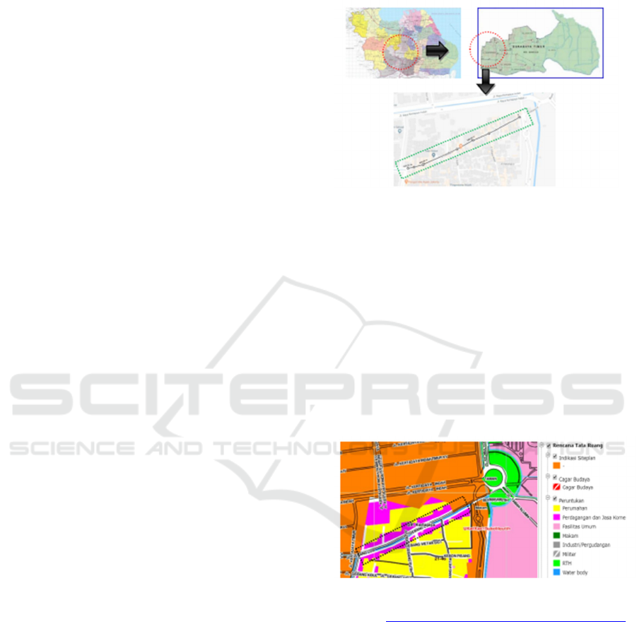
The The location of the city corridor which will be
used as a case study is located on Jalan Gebang Lor,
Gebang Putih Village, Sukolilo, Surabaya. This
corridor segment is located on the outskirts of
Surabaya with a corridor of ± 465 meters.
Figure 1. Map of A. City of Surabaya, B. District of
Sukolilo and C. Corridor of Gebang Lor
Source:
https://id.wikipedia.org/wiki/Berkas:Peta_Kota_Surabaya.
jpg, http://lokanesia.com/peta-kecamatan-sukolilo-
surabayatimur/ & https://www.google.com/maps/@-
7.2812919,112.7875164,17.74z
4.2 Analysis
The following are some elements of the city design
that will be explained in the Gebang Lor corridor area
related to the characteristics, potential and problems
that exist in each component, including:
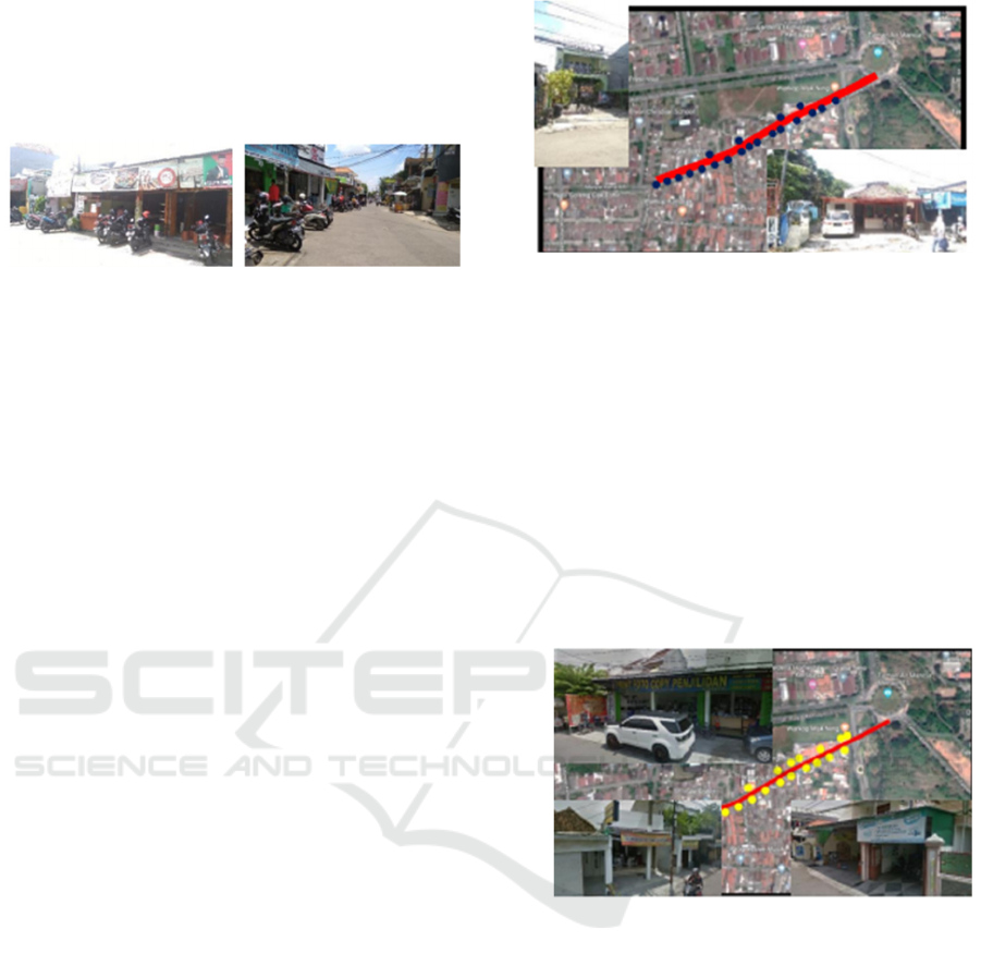
1. Land Use
Figure 2. Gebang Lor Corridor Land Use Map
Source: http://petaperuntukan.surabaya.go.id/cktr-map/
Based on the Land Use map downloaded from the
Surabaya city c-Map site. In the Gebang Lor corridor
it is generally a trading area and commercial services,
while the types of businesses include printing,
photocopying, food stalls, coffee shops, and so on.
The following are the existing conditions of the
Gebang Lor corridor.
AR+DC 2019 - Architecture Research and Design Conference
30

Figure 3. 3D Visual of Gebang Lor Existing
Source : Personal Documentation
Figure 4. Kondisi Koridor Gebang Lor
Source : Personal Documentation
From the above explanation, it can be seen the
potential that develops and the problems that occur in
the object of the case study according to the issues
that develop according to the background. • The
potential that exists in the land use element is in the
area of trade and commercial services, because
almost all of the corridors of Gebang Lor are filled
with various businesses. This has a positive impact on
economic improvement for the surrounding
community. • Problems that occur are in trade and
settlement areas, public parking is a difficult thing for
business owners to provide due to the limited
available land. This is also caused by uncontrolled
land use, as well as existing building line regulations
tend to be ignored. In addition, in this region there are
also no green open spaces and public open spaces.
2. Building Form
In structuring a city, forms and relationships between
masses such as building height, distance between
buildings, building facades need to be known when
looking at building elements. a. Building Height
There are 3 (three) types of building height in the
Gebang Lor corridor area as follows:
1) The height of a 3-storey building is in the mosque
building and several boarding houses with a
building height of more than 12 meters.
2) The height of a 2-storey building, which is part
of a shop and a house with a building height of
8-10 meters.
3) The height of the building is 1 storey, which is in
shop buildings, houses, boarding houses, stalls,
and workshops with a building height of 4-6
meters.
from the photo above it can be seen that the height of
the building is quite diverse. This caused the building
facades to be diverse and unique. In addition, with the
elevation of the building bervaria also gives a tone to
the corridor.
3. Distance of Building
Being in a densely populated area, making the
distance of buildings in the Gebang Lor corridor less
attention. Next is Figurean related to the distance of
buildings in the Gebang Lor corridor.
Figure 6. Distance of Building at Gebang Lor
Source : Personal Documentation
From the photo above, it can be seen that the distance
of buildings in this area is very minimal. Generally,
buildings in this area coincide with each other, so that
this area looks slum.
4. Circulation and Parking
a. Circulation
The circulation path of the Gebang Lor
corridor is a 2-way route, so it can be
accessed from the main ITS roundabout or
from Jl. White Gebang and Jl. Manyar Kerta
Adi. The width of the road in this corridor is
6-8 meters, here are the conditions of the
existing circulation in the corridor of
Gebang Lor.
Figure 7. Circulation at Gebang Lor
Source : Personal Documentation
From the existing conditions, it can be seen
that the circulation path for 2 (two)
directions is very inadequate, especially if
there are vehicles parked on the roadside that
can disrupt existing circulation flows.
Restoration of Public Facilities and Regulation of Gebang Lor Corridor, Surabaya
31
b. Parking
In the Gebang Lor corridor, it does not have
a specially planned parking element, so
generally vehicle parking is only placed on
the highway in front of the building directly.
Figure 8. Condition of Parking and Circulation
Source : Personal Documentation
Judging from these conditions, that the parking
element is needed to support business activities, but
with the limited available land causes this element
can inhibit the flow of circulation in the region.
5. Open Space
In the Gebang Lor corridor, there is no element
of green open space or public open space. This is
due to the high occupancy needs that can no
longer be accommodated by this region. Even
though the need for this element is very
important, because there are many activities in
this region.
6. Pedestrian Ways
In the Gebang Lor corridor, there are no
pedestrian elements. This is caused by limited
available land and no planning in this area.
7. Activity Support
The following are some of the types of
supporting activities found in the corridor of
Gebang Lor.
a. Food stalls
Food stalls located in the corridor of Gebang Lor
are generally simple stalls that provide a menu of
East Javanese specialties and some typical
Padang food. The condition of the building used
is in the form of permanent and semi-permanent
buildings. The following is the distribution point
of the food stalls located in the corridor of
Gebang Lor.
Figure 9. Points of Food Stalls
Source : Personal Documentation
From the photo above, you can see the spread of
food stalls in the corridor of Gebang Lor. It can
be seen that the stalls are scattered in several
points and are generally not side by side.
b. Printing and Fotocopy Business
Gebang Lor Corridor which is located with
several large campuses makes a new business
opportunity in the form of printing and
photocopying. The following is the distribution
point of the printing and photocopying business
in the corridor of Gebang Lor.
Figure 10. Points of Distribution of Printing Business
and Photocopy Source : Personal Documentation
From the photo above, it can be seen the
distribution of printing and photocopying
businesses in the corridor of Gebang Lor. It can
be seen that these businesses are quite widely
available and spread over several points and
some of them are close together.
c. Coffee Shop and Cafetaria
It is known as an area close to several large
campuses, so in addition to printing and
photocopying businesses, there are also many
coffee shops and cafeterias. The following is the
distribution point of the coffee shop and cafeteria
in the corridor of Gebang Lor.
AR+DC 2019 - Architecture Research and Design Conference
32
Figure 11. Pointss of Coffe Shop and Cafetarians
Source: Personal Documentation
From the photo above, it can be seen the
distribution of coffee shops and cafeterias in the
corridor of Gebang Lor. It is seen that scattered
at several points, generally small stalls with
permanent buildings.
7. Signage
In the Gebang Lor corridor, elements in the form
of a signage are located in two areas, namely
located in the entrance and exit of this corridor.
The following is a marker system found in the
Gebang Lor corridor.
Figure 12. Signage at Gebang Lor
Source: Personal Documentation
From the photo, the signage elements used are
different. The most prominent on the marker
system elements located on the west side. This is
because it is the main gate for this region and a
barrier to other regions.
8. Preservation and Conservation
In the Gebang Lor corridor, there is no element
of preservation and conservation. This is because
this area is a trading area and commercial
services and settlements.
The results of the observations described to
produce the development of public facilities in the
form of providing pedestrian pathways as a top
priority, public open space, to improve environmental
functions and economic, social and cultural
conditions, the establishment of a Skywalk. This can
create an interesting visual and physical development
and pedestrian traffic that can improve the quality of
the 10 Gebang Lor environment. The establishment
of the Skywalk can fulfill the seven principles of
Urban Catalyst, which present a new element
positively and have product quality in its context,
namely as the development of the quality of social life
in an economically and environmentally sustainable
society. The formation of the Skywalk can be
designed with eight elements of Shirvani (1985) that
focus on seven principles of the Urban Catalyst.
1. Land Use Concept
Arranging zoning areas between public spaces and
trade and service developments.
Figure 13. Land Use Concept
The concept of land use makes the skywalk the center
of trade and services so that settlement zoning is not
disturbed and can be used as a safer and more
maximal circulation.
2. Building Form Concept
Making a Skywalk with a height that does not exceed
the surrounding buildings and still has a standard
scale that suits the surrounding environment.
Figure 14. Building Form Concept
Source : praline-wordpress.com
The concept of a skywalk building that builds up with
a height that does not exceed the surrounding
buildings, so that it can be used as an intensity view
that is in proportion and scale.
3. Parking and Circulation
Concept With the Skywalk design it can improve
smooth circulation and provide more organized
Restoration of Public Facilities and Regulation of Gebang Lor Corridor, Surabaya
33
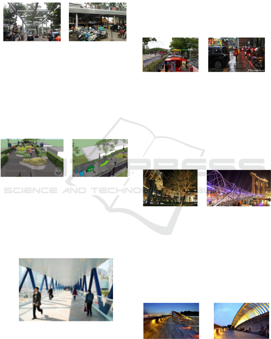
parking with certain land acquisition to maximize the
Skywalk concept.
Figure 15. Parking and Circulation Concept
Source:bandung merdeka.com, nusantara.medcom.id
The concept of circulation and parking that aims to
overcome irregularities in the corridor and provide
new jobs for the surrounding community with a more
organized parking system.
4. Open Space Concept
Open space can be in the form of skywalk with the
intensity of open space can be arranged according to
the arrangement of trade and suits that are on the
skywalk.
Figure 16. Open Space and Retail Concept
Source : radio PRFM, bandung merdeka.com
The concept of open space in the skywalk with
arrangements that are adjacent to the trading area, so
as to maximize each space.
5. Pedestrian Ways Concept
The concept of pedestrians being moved to Skywalk
can develop local economic, social and cultural
qualities.
Figure 17. Pedestrian Ways Concept
Source : Kalimantan-bisnis.com
The concept of the pedestrian path is preferred in the
corridor of Gebang Lor with the aim to maximize the
economic, social and cultural sectors of the
surrounding environment.
6. Activity Support Concept
Maximizing activities that occur on Gebang Lor road
can develop rapidly and quality through the design of
the Skywalk.
Figure 18. Activity Support Concept
Source: prfmnews
The concept of activity that is used as a support for
skywalk is the trade and service sector that can
develop the quality of the skywalk in that
environment.
7. Signage Concept
The characteristics of the Gebang Lor road that can
be formed with the Skywalk pattern can make this
location an investment value that can be characterized
by the influence of new elements on the side of a city
Figure 19. Signage Concept
Source:konfrontasi.com,tempatwisatadisingapore2.blogsp
ot.com
The concept of a marker in the form of identity from
an area with a local concept such as an eco-walk with
a marker as a shopping center and double helix bridge
with a marker as a link to popular places in Singapore.
8. Preservation Concept
Broadly speaking, Skywalk data provides place
values of a city and can be a historical one that is
formed in the future.
Figure 20. Preservation and Place Values Concept
Source : wisatasingapore.net
AR+DC 2019 - Architecture Research and Design Conference
34

The concept of place value presented to show the
progress of the city with its modern style can make
the historical changes from a city to modern
5 CONCLUSION AND
RECOMMENDATIONS
Conclusions from the description above, it can be
concluded that the Gebang Lor corridor is formed by
several elements, one of which is a strong forming
element in the form of supporting activities in the
region. But with the high demand for shelter and trade
and services in the corridor, the area does not have
enough space to accommodate various activities in
the region. The availability of pedestrian elements,
green open space and public open space is difficult to
fulfil due to limited available land. Whereas in city
design, what must be prioritized is the need for
humans, not the need for motorized vehicles. Then
planning is needed as regional development that can
overcome the problems that exist in the corridor. One
of the best choices to be realized is the creation of
skywalk that functions as a pedestrian pathway, and
can be optimized to be used as public open spaces
with integrated green open spaces.
REFERENCES
Bohannon, C.L., 2004. The Urban Catalyst
Concept (Doctoral dissertation, Virginia Polytechnic
Institute & State University).
Budihardjo, E. and Sujarto, D.1999. Kota Berkelanjutan.
Alumni. ISBN 9789794140598
Shirvani, H. 1985. TheUrban Design Process. Van
Nostrand Reinhold. ISBN 9780442280642
Trancik, R. 1986. Finding Lost Space: Theories of Urban
Design (1
st
Edition). Wiley. ISBN 978-0471289562
Restoration of Public Facilities and Regulation of Gebang Lor Corridor, Surabaya
35
