
A Comparative Study on Transformation Process and Form of
Traditional Houses in Sumba Island
Mirzadelya Devanastya and Ayano Toki
Graduate School of Engineering Department of Architecture and Building Science Tohoku University, Japan
Keywords: House Form, Modernization, Sumba, Traditional House, Transformation
Abstract: In a society with no profession of architect nor engineer, the architecture transformation and the space
modification constantly carried out by the local community. Through this process, the local community had
been passed down their empirical knowledge, yet the tradition urged to alter its way according to the
modernization of the architectural culture and people's lifestyle. This study attempts to clarify the
transformation pattern of the traditional house in Sumba Island. We undertook the measurement of the houses
and interviews with the villagers in six villages located in the east and west. Through the comparison of six
villages, we identified clear regional differences in the transformation process and form of Sumbanese houses.
The typical Sumbanese house stands on stilts and topped with the impressive hat. The house has a hearth with
four main pillars surrounded by living space. In general, the transformation of the houses occurred in several
phases, in response to the increasing family members that consequently trigger the necessity of the new
facility. The transformation of form divided into two patterns according to their location, hilltop, and flat land.
These two types characterized by vertical/horizontal expansion of space according to topographical condition,
the changes of room layout in accordance with the religion of occupant, and the introduction of industrial
material which slowly replaces the natural material. We found that in the midst of the transformation process,
the form of high hat and the concept of the four main pillars were maintained. The villagers in Sumba put an
effort on balancing between modernization need and inheritance of the traditional value. The transformation
process shows a manifestation of the adaptation capabilities of traditional Sumba houses in response to the
modern needs of their residents, without sacrificing the important values that strictly maintained by the local
communities.
1 INTRODUCTION
The discussion on Indonesian vernacular architecture
has been held in many forums both national and
international. The term vernacular derived from the
Latin word Vernaculus, which means native or
domestic. Therefore, when it was combined with
architecture and creates the term vernacular
architecture, it gave the value of locality in the broad
meaning of architecture. Hence vernacular
architecture refers to building, which responded to the
needs of the specific people and reflecting the
character of the local environment. It is architecture
that becomes and processed by a particular society
that is located in a certain area (Allsopp, 1980).
Initially, architecture involved as an effort in the
provision of shelter from the surrounding
environment. However, the way architecture
responding to the environment is very dependent on
the knowledge and culture of the people. The culture
itself has characteristics of shifting along with the
passing of time, human knowledge will advance, and
the way we perceive things will be different.
Therefore, there will never be a static architecture.
Vernacular architecture itself will face various
changes in many aspects from the form, material,
even the spatial layout of the building.
The purpose of this research is to observe the
transformation of traditional houses by local people,
which happened in Indonesia in modern days. If
vernacular architecture is constantly changing, it may
be possible to trace and define the pattern of changes
throughout the years. It also aimed to establish a
deeper understanding of how the transformation
process took place in Indonesian vernacular houses,
especially in Sumba island. This understanding is
built on the knowledge of cultural values, which is
accompanied by a process of observation and pattern-
20
Devanastya, M. and Toki, A.
A Comparative Study on Transformation Process and Form of Traditional Houses in Sumba Island.
DOI: 10.5220/0013050700002836
Paper published under CC license (CC BY-NC-ND 4.0)
In Proceedings of the 10th Architecture Research and Design Conference (AR+DC 2019), pages 20-27
ISBN: 978-989-758-767-2; ISSN: 3051-7079
Proceedings Copyright © 2025 by SCITEPRESS – Science and Technology Publications, Lda.

making that will be used as a basis in the effort to
translate the process of assimilating the thought
process of local citizens into architectural form.
2 THEORY/RESEARCH
METHOD
2.1 Theory
Pile dwelling houses in Indonesia are often thought to
be originated from granaries. In Sumba case, the
change from granaries to house is by adding a
platform beneath its floor and enclosed by walls
(Sato, 1991). In Sumatera, the Toba Batak has an old
custom of converting old sopo into dwellings through
a process of transformation that provided better kind
of ruma (Domenig, 2003). The transformations also
indicate the continuity of thought process in
consideration of priority value that has to be
maintained. Certain old features are still in evidence
in the house of Nage, which has undergone
considerable change (Forth, 2003). This suggests that
the house is not a static but a dynamic object, as it
undergoes change throughout the time.
2.2 Research Methods
The spatial archetype of a house can be seen by
observing the relationship between existential values
and the physical appearance of the interior of a house.
Observation starts by analyzing the space that
includes social dimensions and corresponds to a fixed
spatial arrangement (Barbey, 1993). The real essence
of this method is to see the relationship between
house, function, meaning and time as a process of
exchange between physical factors and spatial
dimensions. This method was first put forward by
Barbey when he saw the architect's lack of attention
about how everyday life affects the organization of
space, thought and arrangement of goods in it, or how
all these thoughts change within a certain timeframe.
Certainly, between everyday life and spatial planning
has a very strong influence on one another.
In the scope of traditional society, all elements in
the house have a strong influence and meaning, which
is the implication of the values or norms that are
always enforced. In this case, the community has first
acknowledged the relationship between house
elements and this understanding has kept their homes
well maintained. To better understand how the people
influence the form of their homes, field surveys and
interviews were held with both emic and etic
approach. Comparative analysis then applied to the
acquired data to identify the spatial hierarchy and
identify the pattern of transformation that took place
in the house.
Table 1. Analysis process scheme.
Methods Target Obtained
data
Analysis
Technique
Obtained
resul
t
Intervie
w
House
owner
and
family
members
House
transformatio
n history and
cultural
triggers for
each
transformatio
n phase
3D
conversion
and
comparativ
e analysis
of change
through
each period
of time.
House
transformatio
n pattern and
diagrams
Observat
ion and
measure
ment
Current
conditio
n of the
house:
Current
house form
Current
house form
used as a
compariso
n basis.
Hierarchy of
space and
archetype, as
well as the
existing
values of the
house
3 RESULT AND DISCUSSION
3.1 Early Settlement and Distribution
Sumba is an island that belongs to the administrative
region of East Nusa Tenggara Province in Indonesia.
Stretches on the east side of Bali, the Nusa Tenggara
archipelago loses its tropical lushness and becomes
arid. Its proximity to Australia makes the transition
between tropical and dry climate. Therefore, when
other tropical islands are being characterized by its
fertility and vast jungle area, the environment in Nusa
Tenggara, including Sumba, tends to be dominated by
extensive grassland. The island is inhabited by people
with a mixture of Malay and Melanesian races and
adheres to the caste system in its social structure. This
condition has a major influence on the culture and
beliefs of Sumbanese people, which later will
intersect with their mindset that underlies the habit of
building their houses.
Marapu is the form of ancestral religion practiced
by the people on this island. The ancestors are
believed to be closely associated both in the form of
the house and the village arrangement as well. A
striking feature of the village layout is the intimate
connection between the dead and the living, of tombs
and houses, within the same space. This connection
resulting in the triadic division of space in the village,
with two opposing ends mediated by center
(Waterson, 1990). Therefore, every village has two
A Comparative Study on Transformation Process and Form of Traditional Houses in Sumba Island
21

entrance point on either side, and a field in the middle
with stone tombs erected on it.
Sumbanese house which called rumah adat in
Indonesian language has striking features in its form;
a wide thatched roof with a high towering hat in the
middle. This kind of house can easily be found
throughout the island, with variations in size and
height depending on its location, which will be
discussed in depth later on. The houses can be found
mostly in the villages, usually on the top of the hill,
or on the lowland near the river or beaches, depending
on the age of the village itself.
Sumba is culturally and politically divided into
western and eastern areas. The western part of Sumba
has been divided by warring fiefdom for centuries,
contrary to the east side which, although sparsely
populated, is more politically dominant. (Barry
Dawson, 1994). In terms of geography, Sumba island
is characterized into two regions; the eastern Sumba
with its vast savanna and hills, and western Sumba
with its mountainous topography and dense forest.
Six villages were observed in the process, and the
result discussion will be focused on classification by
hilltop and flatland villages.
3.1.1 Hilltop Village
The village located in the hilltop usually classified as
the old and sacred one. To reach this village, it
requires between 30 minutes to two hours hike to
reach depending on the accessibility from the nearest
road. Parewa Tana is one of the older established
villages on the western side of Sumba island.
According to the interview, the village was
established in approximately 1850. The house layout
is arranged in lengthwise in the north to the south line,
following the available space in the topographic
character of the site. Contrary to the character of the
flatland village, the houses in hilltops are mostly
arranged in parallel lines with the distance between
each house being really dense due to the availability
of the vacant land on the site.
The population of hilltops villages is currently
declining, on average of only inhabited by 50 people
or less, with mostly adults and elderly. This is due to
the fact that the majority of the youngsters decided to
move out of the village to the city for employment
reasons or being taken as the bride for other village
members. Therefore, the only remaining people who
still live in the village are the one who has a certain
position in the hierarchy of the village such as village
leader and indigenous elders.
3.1.2 Flatland Village
Contrary to the hilltop, the flatland village is located
in close proximity to big cities in Sumba. Most of the
flat land village is established as an expansion
settlement from the hilltop, as people came down to
work in the cities. The village characterized by having
a wider land area with groups of stone tombs erected
on the inner circle and several houses arranged on the
outer circle facing the tombs.
The majority of flatland village residents are
working in the cities and much more exposed to
technological progress. Therefore, their lives are
exposed to the many influences brought along with
the development of knowledge and technologies. The
ease of access to the village also influences the
change in religious belief from marapu to other
religions such as Christianity or Islam. This religious
transformation is one of the factors that greatly
influence the transformation of form and values in the
spatial hierarchy of the Sumbanese house.
Upon surveying the villages, the data is then
categorized to find and highlight the connection
between each village’s statistics and current physical
condition. Since the west Sumba was dominated by
hills and mountains, it is obvious that the majority of
the villages are established in the hilltop area. The
opposite also is seen in the eastern part of Sumba,
where the majority of villages are established on flat
lowland. Furthermore, by looking at the traced house
configuration image, the difference between the
hilltop and lowland villages are easily
distinguishable. The houses on the hilltop villages are
arranged in a line and the distance between houses is
very dense. The reason for this configuration can be
analyzed by comparing it with the aerial images, and
it is likely that the line shape is following the
character of the topography, as well as in the inner
circle boundaries of the surrounding forest. On the
other hand, the land in the lowland villages is much
wider than the hilltop one, and it can also be noted
that the distance between the houses is much wider.
AR+DC 2019 - Architecture Research and Design Conference
22
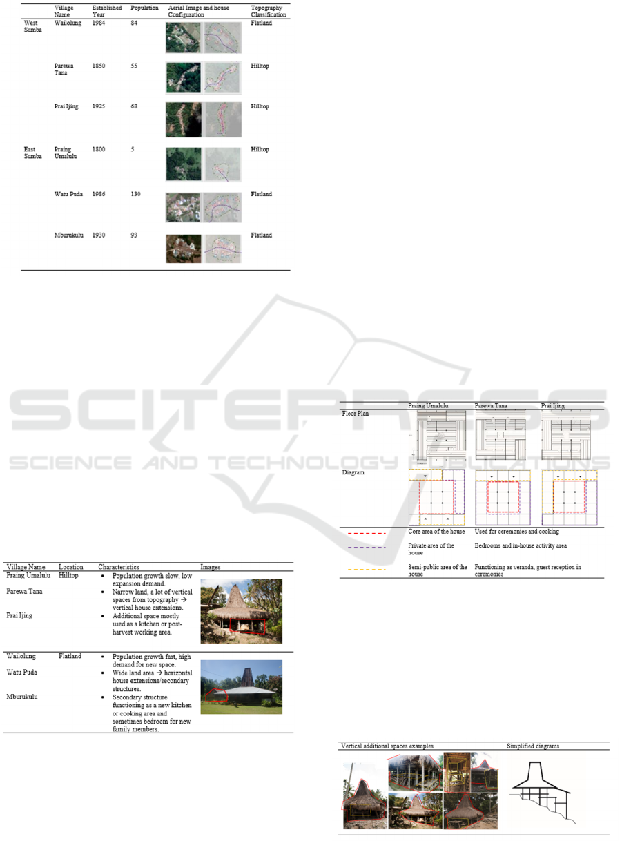
Table 2. Statistic data comparison between six villages
The differences in village characteristics are more
visible when grouped into two types: hilltop and
lowland villages. Topographically, the hilltop
villages are dominated by differences in land contours
which resulting in small areas of land that houses can
be built. With a tight distance between the houses and
being squeezed by ravines and forests, there is no
horizontal space left in the village. However, as the
population is growing, each house has a need to create
additional spaces for new family members. On the
contrary, the flatland villages have more spacious
land area, therefore the residents have more space and
freedom to develop their homes, following the
demand of the population increase.
Table 3. Village grouping based on topographical
characters
3.2 House Transformation Typologies
The transformation of the house of Sumbanese people
is a result of the adaptation of the people in response
to the changes in their daily lives and the sustainable
system imposed in the house construction methods.
The system is the building method that focused on
knockdown that provides easiness in assembly and
disassembling, resulting in the freedom to rearrange
the house configuration. The understanding of the
spatial hierarchy and division of space is achieved
through the conversion of floorplan into diagrams.
The comparative analysis of the diagrams of the
houses from different villages showing the current
forms, although different in some elements, has
particular rules that apply in all of the transformation
process. In the hilltop area where marapu religion is
still highly believed, the core area of the house
doesn’t experience significant transformations. The
four main pillars and inner hearth still act as sacred
place with only minor transformations are allowed
such as adding or removing partition walls. The walls
are built to accommodate the division of space
according to the numbers of family members. The
space surrounding the core area is more flexible in
experiencing changes in function. The house owners
can easily transform semi-public space such as the
veranda into private space to accommodate the need
of a bedroom as the family member grows from time
to time.
Table 4. Hilltop village house sampling and diagrams
Along with the growing number of family members,
the need for space constantly increases. The
limitation of the land area in the village compels the
villagers to outsmart it by constructing new spaces
vertically, taking advantage of land contours. Vertical
transformation becomes a pattern that mainly adapted
and developed over time in the hilltop villages.
Table 5. Vertical additional space in hilltop villages.
A Comparative Study on Transformation Process and Form of Traditional Houses in Sumba Island
23
The houses in flatland villages undergo a more
varied transformation pattern compared to the hilltop
villages. Land availability triggers a more varied and
flexible transformation pattern, unlimited by the
envelope of the main house. As the majority of the
people changed their religion into Christianity or
Islam, any house elements related to the marapu must
be removed. This highly affects the core space of the
house as the inner hearth that acts as a pivot in
ceremonies is removed entirely from the house.
However, the removal of the inner hearth also meant
losing the cooking area, which usually responded by
constructing a new kitchen outside of the main house
area. The variety and flexibilities of transformation in
flatland area also affected by the modernized and
adaptation of new lifestyle that gradually introduced
by both government programs and the increasing
number of young family members who attends higher
education level. Amenities such as electricity,
television, piped water, cement paths, factory cut
wooden materials, and corrugated iron or zink roofing
is a common thing to find. Thus the transformation
that occurred in the houses is more rigid and
permanent, utilized in the long run.
Table 6: Flatland village house sampling and diagrams.
From the observation on flatland village extension
patterns, there are three types of secondary
house/structure typologies. The first type is the
secondary house that connected to the main house by
the floor, however, it has separate and independent
roofs and structures. Although the secondary houses
are built independently, it has floor connection to the
main house for easy access purpose. The second type
is the secondary house as extension part of the main
house. This type occurs in a house where the owner
of the house only have limited ownership of the land
in the village. The third type is the secondary house
that completely separated and structurally
independent from the main house. The third type
usually established in wealthy family house where
they can afford to build large kitchen areas, and
sometimes also includes the addition of other room
functions such as bedrooms and horse stables
Table 7. Horizontal additional space in flatland villages.
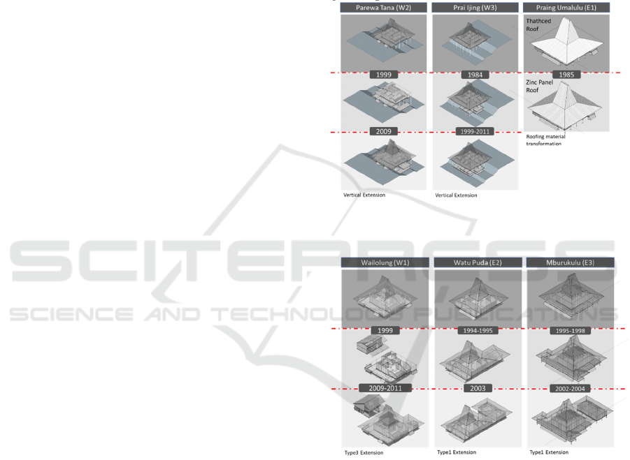
3.3 House Transformation Phase
Tracing the transformation history of houses in
Sumba also implies tracing the social history of the
said house. This attempts to indicate the connection
of events on the particular years that influence
significant transformation to the chosen house.
Through the interpretation of existing construction
language, combined by the stories of the owner of the
houses as well as the neighbors who helped in the
construction process, it can clearly be assumed that
the house experienced several transformation phases
in the process. From the hilltop house transformation
diagrams, there are two villages with whom the house
experienced major transformation. With the
exception of the house in Praing Umalulu as the
village is considered sacred and spatial
transformations are prohibited by the marapu
religious leaders. The strictness of these rules is an
indicator to be considered that this house has the basic
form of Sumbanese traditional house.
From the three-dimensional interpretation (figure
1 and 2) there is a difference in thought patterns
between hilltop village dwellers and flatland villages
in creating additional space in their houses. There are
several important factors that need to be taken into
account in understanding the transformation process
of houses in hilltop villages. First, its topographical
AR+DC 2019 - Architecture Research and Design Conference
24
characters force people to look for chance to
transform while keeping in the boundaries of marapu
rules and make use of what they already have in their
environment. This means the keeping of core area
intact and divert to converting space that is less
influenced by religious provisions. Thus the people
tend to convert the semi-public veranda into private
bedroom by adding walls or creating additional
platforms on the side or under the house. Secondly,
the access difficulty of the village creates limitations
in the distribution capabilities of materials that
originated from the cities. This means the lack of
external influence in the transformation process,
making the ancestral knowledge of building methods
intact. This can be seen on the partition walls made of
natural materials such as bamboo and wooden deck
floor that are made easily dismantled anytime. This
method provides flexibility values that are utilized by
the residents of the house to change the arrangement
of space at any time as needed.
Flatland village houses on the other hand have
more freedom in their transformation experience.
First of all, the flatland villages are usually
constructed as settlement derived from the hilltop
village, as an effort to create easier access to and from
the cities. Many hilltop villagers decided to move
down the hill to settle in these villages. Contrary to
the hilltop village, the communities in flatland
villages are more open to the external influence
brought in by the migrants or the citizens who study
or working in the cities. This acceptance of external
factors influence heavily on the development of
people’s mindset, including the patterns and house
building methods. The decline in marapu religion is
one of the indicators which on one hand erases a lot
of values in the house, but on the other hand, becomes
a substantial factor in creating opportunity for the
flexibility of major changes in their homes that
triggers the emergence of secondary structure.
This interesting development appears to involve a
fundamental change in the way of living in
Sumbanese society. The majority of secondary
structures allocated as kitchen with some additional
space such as other bedrooms or horse stable,
depending on the needs of the homeowner.
Interestingly, the building method of the structure is
the combination of old knowledge with the use of
modern building materials, especially for the roofing.
The hearth part, still using the similar block of stone
pedestal propping up the fireplace and encircled by
four roofing pillars. This effort to maintain the hearth
as closely related to old hearth they had removed
shows that although it has been moved to a place
separated from the main house, the kitchen as space
and cooking activities still regarded as closely related
to their ancestral values. Other spatial functions such
as food storages were moved with the same layout
concept, over the hearth to ensure the benefit from
smokes from the hearth. Therefore, even though the
moving of the hearth from the main house also
implying the moving of core activity area to the
secondary structures. As the hearth removed and the
activities changes, the core of the main house remains
as symbolic of the culture and status shown to the
general public
Figure 1. Three-dimensional interpretations of house
transformation phases in hilltop villages.
Figure 2. Three-dimensional interpretations of house
transformation phases in flatland villages.
A Comparative Study on Transformation Process and Form of Traditional Houses in Sumba Island
25
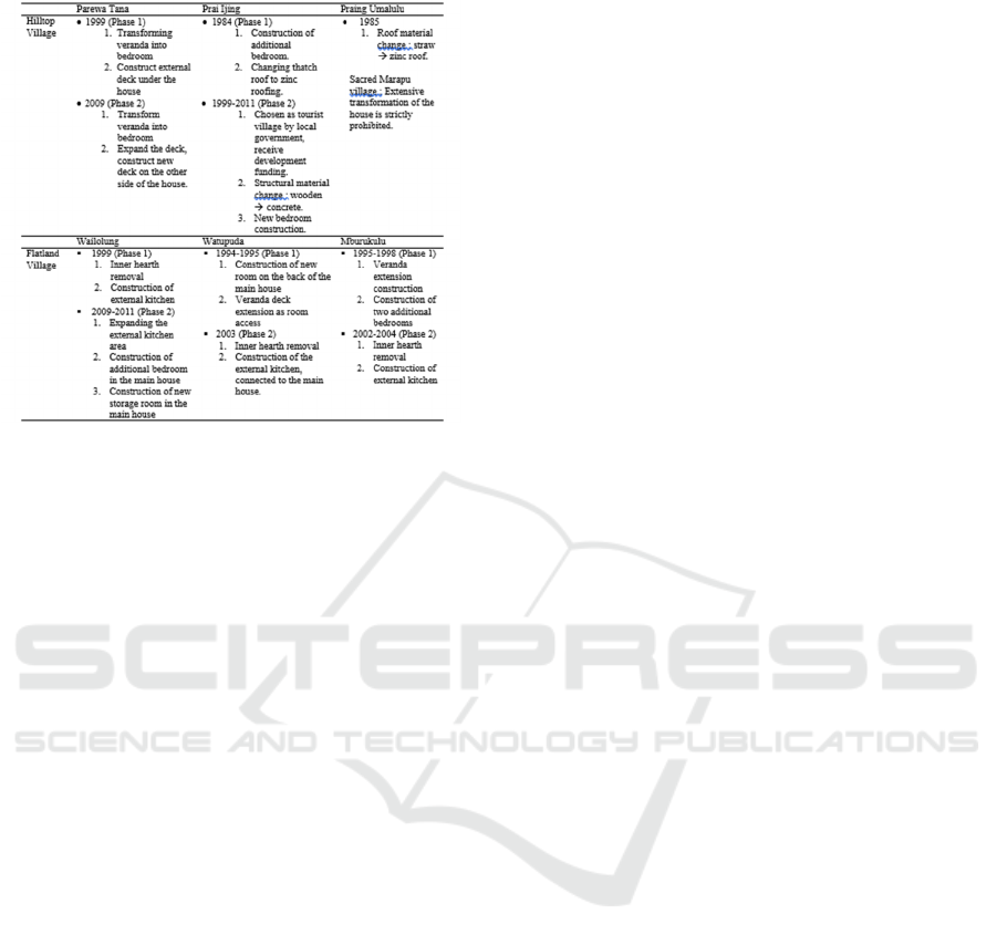
Table 8. Transformation phases informations.
The transformation table above indicated that there
are two types of transformation in a house. Minor
transformations such as maintenance and
replacement of old materials that happened frequently
once every three to four years were not mentioned in
the table as it did not affect the house form
significantly. Major change on the other hand occurs
gradually and divided into several phases. It is
interesting that from the 6 houses, the phases can be
collected into two groups. The first phase of
transformation in hilltop village occurred in the span
of the 80s to the 90s where most of the
transformations are making a new bedroom. This is
quite contrary to the flatland villages as the majority
of the new bedroom constructions occurred in the
second phase. This may suggest the gap of the
emergence of new generations between those
villages, indicating the declining of the village
population as there are no demands for the new rooms
on the second phase of the hilltop village in a similar
timescape.
In the flatland village, the transformation phases also
can be grouped into two time frame where the first
one occurred in a much longer span between 1994 to
1999 and the second phase is between 2002 to 2011.
For a village that the majority of the people converted
into non-marapu religion, ceremonial associated
inner hearth was the main element of the house that is
removed and triggers the construction of new kitchen
area as replacement of cooking space. On the other
hand, there are socio-economical factors that affect
the transformation of flatland village as more of the
young population attend to higher education and
bring knowledge into the village communities. As a
result, there is tension between ancestral practices
pertaining to the free but time-consuming application
of natural material to modern knowledge and the idea
of time-saving but money consuming prefabricated
house materials.
4 CONCLUSIONS
The comparative analysis on transformation of house
form in Sumba indicates the strong connection
between the topographical location of the houses and
the transformation pattern that occurred. The
transformation in Sumba houses are divided into two
axes, either vertically or horizontally, and the location
of the house greatly influences the direction of
change. In a hilltop village, the transformation is done
vertically, creating a trade-off between the limitations
on internal space modification caused by religious
factor and dense layout between the houses, with
flexibility utilizing empty space under the house. On
the other hand, the flatland village house utilizes the
abundance of land availability which enhances the
flexibility in repurposing and transforms the form of
the house.
The changes in socio-cultural factors on village
communities also influence the type of necessities
that triggers the form of newly constructed facilities.
The hilltop villages focus on constructing new
bedrooms to get around the growing number of
family members. The persistence of marapu religion
creates limitations in transforming the core part of the
house, leaving it intact until current time. In flatland
villages, marapu religion has faded resulting in the
removal of strongly related house element especially
the hearth. Thus the majority of new erected space is
appointed as kitchen. Moving the kitchen from the
main house to the outside also impacts the kind of
activities took place inside the main house. The main
house become solely used for sleeping and receiving
guest, and the other family gathering activities
happen around the kitchen in the secondary structure.
This research implies that in a society where there is
no profession such as architects, the house evolved by
constant spatial modification carried out by the local
community. Through this process, the knowledge of
local architecture not only passed down to the newer
generation but also received new values that influence
the form of the house. Therefore, the research on this
topic should be discussed more frequently to maintain
the updated analysis on the latest form of the house.
AR+DC 2019 - Architecture Research and Design Conference
26

REFERENCES
Adams, R. L. (2008). The megalithic tradition of West
Sumba, Indonesia: An ethnoarchaeological
investigation of megalith construction. Dissertation
Abstracts International Section A: Humanities and
Social Sciences, 69(4-A), 1415.
Adams, R. L., & Kusumawati, A. (2010). The social life of
tombs in west Sumba, Indonesia. Archeological Papers
of the American Anthropological Association, 20(1),
17–32.
Alone, S., Liang, T. M.-, & Laxton, W. (n.d.). Breathless :
Making Build- ings and Weather on Sumatra. 72–82.
Asih, E., & Dwi, A. (2015). Gendered Space in West
Sumba Traditional Houses. DIMENSI (Journal of
Architecture and Built Environment), 42(2), 69–75.
Asquith, L., & Vellinga, M. (2006). Vernacular
Architecture in the twenty-first century. 313.
Creangǎ, E., Ciotoiu, I., Gheorghiu, D., & Nash, G. (2010).
Vernacular architecture as a model for contemporary
design. WIT Transactions on Ecology and the
Environment, 128(March), 157–171.
Ellen, R. F. (2013). Microcosm, Macrocosm and the
Nuaulu house: Concerning the reductionist fallacy as
applied to metaphorical levels. Bijdragen Tot de Taal-,
Land- En Volkenkunde / Journal of the Humanities and
Social Sciences of Southeast Asia, 142(1), 1–30.
Ellisa, E., & Pandjaitan, T. H. (2015). INTERIOR
ARCHITECTURE OF VERNACULAR MBARU
NIANG OF WAE REBO ( Toga H . Panjaitan ,
Evawani Ellisa ) INTERIOR ARCHITECTURE.
(September 2016).
Gruber, P., & Herbig, U. (2005). Research of
Environmental Adaptation of Traditional Building.
Architecture, (Hb 2).
Hourigan, N. (2015). Confronting Classifications - When
and What is Vernacular Architecture? Civil
Engineering and Architecture, 3(1), 22–30.
Mross, J. W. (2000). Cultural and Architectural Transitions
of Southwestern Sumba Island, Indonesia. Acs4 2000
International Conference, 260–265.
Muslimin, R. (2017). Toraja Glyphs: An Ethnocomputation
Study of Passura Indigenous Icons. Journal of Asian
Architecture and Building Engineering, 16(1), 39–44.
Pandjaitan, T. H., & W, A. B. (2017). Transformed Seabed
of the Sama Bajau The Disappearance of Coastal
Vernacular Settlements [ Pick the date ] Transformed
Seabed of the Sama Bajau. (April).
Panjaitan, T. H. (2017). Hybrid Traditional Dwellings:
Sustainable System in the Customary House in Ngada
Regency. International Journal of Technology, 8(5),
841.
Rashid, M., & Ara, D. R. (2015). Modernity in tradition:
Reflections on building design and technology in the
Asian vernacular. Frontiers of Architectural Research,
4(1), 46–55.
Sato, K. (1991). Menghuni Lumbung: Beberapa
Pertimbangan Mengenai Asal-Usul Konstruksi Rumah
Panggung di Kepulauan Pasifik. Jurnal Antropologi
Indonesia, no.49, 31-47.
A Comparative Study on Transformation Process and Form of Traditional Houses in Sumba Island
27
