
Simulation Plan Hydraulic Polder Banger System
on the Flood of Rob City of Semarang
Ikhwanudin
1
, S Imam Wahyudi
1
and Soedarsono
2
1
Doctoral Program of Civil Engineering, Professor of Civil Engineering, Senior Lector of Civil Engineering, Indonesia
2
Doctoral Program of Civil Engineering, Professor of Civil Engineering, Senior Lector of Civil Engineering
Keywords: Storage Variation, Catchment area, Pump.
Abstract: Flood is a common problem that occurs in some parts of Indonesia, especially in densely populated areas such
as in urban areas, The cause of the flood itself can occur due to various things both natural and human. Flood
that occurred in Semarang Central Java, in general is caused by several problems among them due to the
increase in discharge, base silting of river body and river narrowing due to sedimentation, Catchment area
and also caused by the imbalance between the incoming water, water coming out on city drainage channels,
Another problem that often arises is the tide of the sea (Rob) in some parts of the territory that are subscribed
to a puddle due to rob. Furthermore, the frequency of rainfall was analyzed by Log Pearson Type III method,
Gumbel and Haspers, then calculated flood discharge plan with Rational method, Weduwen, and Haspers.
From the results of flood discharge planning analysis, to find out runoff used flood discharge when re-5 years,
with rainfall from Gumbel method R5 = 130.473 mm with Q5 average = 102.677 m3 / dt From the calculation
shows that there is an increase of flood water level that can no longer be accommodated by Banger times. The
research method is done by hydraulic simulation of robotic flood of Semarang city by comparing field data
and simulation through Catchment area variation, through storage variation, pump variation and through
monitoring / observation of water elevation For 100% storage while 50% Retention Pool and long storage
0.25%.
1 INTRODUCTION
Semarang is one of the areas that prone to the flood.
The main problem faced in Semarang is the problem
of the flood with a long pool. In addition, the problem
of drainage systems with reduced function and
capacity, increased drainage load due to land
conversion, saltwater intrusion, decreased soil
elevation symptoms, sea level rise as a result of global
warming, less optimal operation and maintenance and
law enforcement which is still low. To overcome this
problem required flood control strategy with various
techniques and technology.
In this activity, many flood simulation simulations
are performed on existing drainage and river systems
with numerical models. The simulation scenario starts
with studying the existing condition, the
normalization of the groove and the elevation of the
embankment, the manufacture of polder technology
to the offshore draft. The location of the research was
conducted in several watersheds from upstream to
downstream (estuary and offshore) and certain
locations that experiencing floods and puddles around
the city of Semarang. that until now cannot be
overcome.
The coverage of the current flooding area has been
widespread in some areas including the estuary of
Kali Plumbon, Kali Siangker around Achmad Yani
Airport, Karangayu, Kerobokan, Bandarharjo, along
the road in Mangkang, Tugu Muda area - Simpang
Lima to Kali Semarang, banger times, in Genuk from
Kaligawe to the Demak border (City Government of
Semarang, 2011). The main problem of Semarang
City drainage system is sea level rise as the result of
the global warming and land subsidence. In addition,
due to the decrease of the drainage/flood capacity
caused by sedimentation, garbage, illegal building,
increased drainage load due to land conversion that is
not followed by the return of recharge and catchment
function, operation and maintenance is not optimal
and law enforcement (law enforcement) still weak
(Wahyudi, 2010).
178
Ikhwanudin, ., Wahyudi, S. and Soedarsono, .
Simulation Plan Hydraulic Polder Banger System on the Flood of Rob City of Semarang.
DOI: 10.5220/0009008101780183
In Proceedings of the 7th Engineering International Conference on Education, Concept and Application on Green Technology (EIC 2018), pages 178-183
ISBN: 978-989-758-411-4
Copyright
c
2020 by SCITEPRESS – Science and Technology Publications, Lda. All rights reserved

Some parts of the Semarang area are lowlands and
some of them are lower than the sea level, then this
area receives rainwater flow from upstream, local rain
and tidal water. Some simple polder system has been
applied in the city of Semarang including feather
drain subsystem, Tanah Mas, and Tawang. Some
simple polder system has been applied in the city of
Semarang including feather drain subsystem, Tanah
Mas, and Tawang. However, the system has not been
optimally functioned because of the problem of
retention pond capacity, channel condition and pump
capacity, and institutional management of the polder
system. In addition, due to land subsidence and sea
level rise in the North Coast of Central Java, although
there is no rain, in some areas in the north of
Semarang are inundated by seawater at high tide
called ROB. When the rainfall is high, the puddle area
has a more expansive area. Losses resulting from the
flood/puddle of rob the longer the increase over time
namely damage to residential buildings, factories,
residential areas, environments and other
infrastructure Global warming is indicated to be the
cause of sea level rise. When the atmosphere warms
up, the ocean surface layer will also warm up, so the
volume will expand and raise the sea level (Nguyen
et al., 2016).
Changes in sea level affect the life in coastal areas
and can drown some land through estuaries, river
networks and drainage.Changes in sea level affect the
life in coastal areas Another cause of tidal flooding in
Semarang City is land subsidence. Based on the
measurement and analysis of land acquisition in the
area around the Port of Tanjung Emas an average of
6.5 cm per year (Wahyudi, 2007).
In order to improve the condition and to anticipate
the possibility of increasing complexity of flood /
puddle problem, it is necessary to study the
phenomenon of the sea tide elevation increase and
land subsidence, modeled mathematically and
physically as the basis for drafting / handling of robot
handling concept Then the need to study similar cases
in some overseas advanced cities are more
experienced in handling, so as to develop an
implementation polder system especially in the city
of Semarang.
1.1 Problems
Flood control with polder system in some
locations is still less optimal so that floods still
occur.
Soil subsidence is slowly occurring in some
polder subsystems due to uncontrolled
groundwater extraction and has resulted in the
topography of the terrain at that location to be
lower than the flood waters so that in that
location floods and puddles are still occurring.
1.2 Research Purposes
The purposes of the study is to get a good formula for
the strategy of handling and managing the good and
efficient time of Banger Watershed. Then what needs
to be done is collecting data compartment with
experimental data below.
To know the characteristics of Retention Pond
To know Banger Polder Channel Capacity
Formulate the Banger Polder System
1.3 Literature Review
Polder is an urban drainage handling system by
isolating the area served (catchment area) to the entry
of water from outside the area, either in the form of
overflow or subsurface flow (culvert and seepage),
and control the flood water level inside system
according to plan. Properties of Polder System
include:
The polder region is well-defined, where water
from outside the area should not enter, only
rainwater and sometimes seepage water, in the
area itself collected.
In polders there is no free surface flow as in
natural water catchment areas, but is equipped
with a control building at its disposal (with a
drain or pump) to control outflow.
Water faces in polders (surface water or
subsurface water) are not dependent on the
water surface in the surrounding area and are
assessed by land elevation, soil properties,
climates, and plants. The polder system
component consists of These are 1) Mobile
embankment and / or sea defense, or other
insulation construction 2) Field drainage
system 3) Conveyance system 4) Storage pond
and outfall system 5) Water body recipient
waters (Segeren, 1982)
Based on the definition can be concluded that the
object of the polder system is an area with the
following characteristics: 1) Isolated as a unit of
hydrological system that is not affected by the
surrounding system, 2) Surface water and ground
water can be controlled in such a way, 3) Areas that
are in natural condition are often inundated (flood
area).The polder system is a closed water system with
embankment elements, pumps, conduits, retention
pools, landscape arrangements, municipal water
Simulation Plan Hydraulic Polder Banger System on the Flood of Rob City of Semarang
179

installations. This Polder system must work a unified
system and integrated with a more macro drainage
master plan (Wahyudi, 2012).
Polder system is a way of handling flood with
physical building, including drainage system,
retention pond, embankment that surrounds the area,
as well as pump and / door of water, as an integral
water management unit (Pusair, 2007). Construction
of polder system can not be done individually, but
need to be planned and implemented in an integrated,
adjusted to the spatial plan of the region and the water
system in a macro. The combination of pump capacity
and retention ponds should be capable of controlling
the water level in a polder area and not negatively
impacting the drainage system on a macro basis.
Completeness of physical facilities for polder system
include: embankment for insulation with seawater,
drains, retention ponds (tank) and pumps (Rosdianti,
2009)
The concept of a polder system is a concept of
closed water system using seepage embankments and
sluice gates so as to be the right solution in
overcoming the problem of flooding and inundation
in low areas (Wahyudi et al., 2017). In addition to
flooding from the sea, this system can also protect the
area in the embankment from floods due to rain
through a system of watering management (Mah et
al., 2011)
The polder system is built to prevent water from
flowing back into the system by using the pump in
case of rain. Water expenditure in the system can be
done by gravity when the water level in the river is
lower than in the system (Taborda & Riberio, 2015).
Based on the definition can be concluded that the
object of the polder system is an area with the
following characteristics: a. Isolated as a unit of
hydrological system that is not affected by the
surrounding system, b. Surface water and ground
water can be controlled in such a way, c. Areas that
are in natural condition are often inundated (flood
area).
There are several disadvantages of the polder
system: 1) In the drainage is done by pumping, this is
due to natural conditions, 2) High operational costs
compared to the gravity system. 2) If the pump
condition is disrupted then the pump can not operate
so the reservoir pump must be provided. 3) Cleaning
should be routine
1.4 Sea Level Rise
Global warming affects the weather, sea level, beach,
agriculture, wildlife and human health. When the
atmosphere warms up, the ocean surface layer will
also warm up, so the volume will expand and raise the
sea level. Changes in sea level will greatly affect
coastal life. A 100 cm increase would drown the
Netherlands, 17.5% of Bangladesh, and many islands.
When the high oceans reach the mouth of the river,
floods due to high tides will increase inland.
1.5 Land Subsidence
Indication of land subsidence in Semarang can be
known from several data sources. Based on
measurement and data of land subsidence in the hilly
area in Semarang city is smaller than the decrease in
coastal area. From field observations of land
subsidence in the former swamps and ponds showed
a decline the largest, for example in Tanah Mas
housing, Tanjung Mas Beach, with a decrease
between 5.5 - 7.23 cm per (Marfai & King, 2008).
2 RESEARCH METHODOLOGY
The data collection used in this study consisted of
primary and secondary data. Primary data is data
obtained directly from the object of research in the
field or can be an interview to the parties concerned.
While the secondary data is obtained from related
institutions that have the completeness of the data as
needed eg topographic map, flood discharge data,
land use map, drainage network system data, tidal
data and sea water waves and data of land subsidence
(landsubsidence).
3 RESULTS AND DISCUSSION
3.1 Catchment Area Polder Banger
Polder Banger has a catchment 675 ha area, located
in East Semarang, has a river length of 13,326 km
This Polder has its equipments which include
retention pond area of 9.8 Ha and 5 pumps with
capacity of 2 m3 / sec. When the retention pond is still
a natural reservoir. The Kali Banger Polder System
has an infrastructure component comprising (Mondel,
2009) Northern dike (North Artery Dam
Arrangement), protecting the Kali Banger Polder area
from sea level, Eastern dike (East Flood Canal Flood)
protecting the Polder area from the East Flood Canal
River, Dam Banger River (Pembangunan Bendung
K.Banger) that closes the flow connections from the
Polder region to rivers and seas, currently where
temporary shutdowns are located downstream near
EIC 2018 - The 7th Engineering International Conference (EIC), Engineering International Conference on Education, Concept and
Application on Green Technology
180
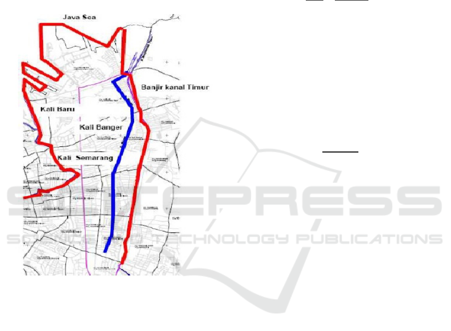
the pumping station Pumping station is enabled to
control the water elevation because the Polder area is
covered by a weir, Retention basin (Retention Pond)
is used for system water level control polder before
pumping.
Water elevation in the retention pool is controlled -2
m MSL natural retention pool of large polder banger
that is 9.6 ha using 5 pumps with capacity of 2 m
3
/ s.
Figure 1 Catchment area polder Banger.
The boundary embankments around the Banger
polder basin are as follows:
1. north: Java Sea
2. south: Jl. Brigadier Katamso;
3. west: Kali Baru and Kali Semarang;
4. east: East Flood Canal Levee
Folder-based analysis with scale of 1.5000 in wide
catchment area of banger 675 ha
3.1.1 Rainfall Analysis
The intensity of rain is the rainfall that occurs during
a period of time when the water is concentrated. The
general nature of the rain is the shorter the rain the
intensity tends to be higher and the greater the
repetition period the higher the intensity (Suripin,
2004)
To find the polder effectiveness measured by the
polder's ability to control flooding. The first step is to
find the average rainfall. one of the calculation of
rainfall intensity is using Mononobe method. As seen
in Equation (1).
I
24
24
24
/
10
(1)
Where, I is the rainfall intensity (mm / hour), R24
is an annual maximum annual rainfall for the year t
reset (mm) and tc referes to concentration time
(hours).
Rain depth is determined by Hyeteograph
calculation using Alternating Block Method (ABM)
method. From the value of Hyeteograph can be
obtained Rain Effective with the formula as presented
in the equation. (Triatmodjo, 2008).
Pe
,
,
(2)
Where, Pe is an effective rain depth (mm), P is the
rain depth (mm) and S is for maximum water
potential retention by soil, which is mostly due to
infiltration (mm).
Based on the rainfall analysis, the analysis of
rainfall frequency using Log Pearson Type III,
Gumbel and Haspers method, Flood discharge plan
with Rational method, Weduwen, and Haspers. From
the results of flood discharge planning analysis, to
find out the runoff used flood discharge when re-5
years with rainfall from Gumbel method R5 =
130.473 mm.
3.1.2 Flood Debit Analysis Plan
In the case study on the flood problem of Kali Banger
Kota Semarang, it begins with secondary data
collection related to location and inventory of rainfall
data and data of existing condition of Banger River.
Furthermore, the analysis of rainfall frequency using
Log Pearson Type III, Gumbel and Haspers method,
then calculation of flood discharge plan with
Rational, Weduwen and Haspers method. From the
results of flood discharge analysis of the plan, to find
out the runoff used flood debit when re-5 years with
rainfall from Gumbel method R5 = 130.473 mm with
Q5 average = 102.677 m
3
/dt. From the calculation
shows that there is an increase in flood water level
Simulation Plan Hydraulic Polder Banger System on the Flood of Rob City of Semarang
181
that can no longer be accommodated by Kali Banger.
To know the runoff used flood discharge when re-5
years with rainfall. From the calculation results show
that the increment of flood water level that is no
longer able to be accommodated in banger times, and
briefly the calculation of flood analysis Concluded
the design flood discharge obtained certain periods
for example for Q5th the discharge used is 130.473
m
3
/dt
Tabel 1: Flood discharge design.
Return Perio
d
Year’s
Q Average Design
(
m
3
/dt)
2 96.56
5 102.67
10 120.33
20 128.44
25 131.28
50 138.52
Flood debit analysis at Banger times is
summarized in graph (rating-curve) which shows the
relationship between flood discharge (m
3
/dt) and time
(hours). Where the maximum discharge (Qmax-5th)
was obtained for 102.677 m3 / dt.
Figure 2: Flood of Banger times.
3.1.3 Hydrograph Unit Analysis
The first step to find out the correlation model of
catchment area, water storage, pump capacity in
polder system is data collection of rainfall data
obtained, conducted hydrological analysis resulting
in flood discharge plan, which then processed again
to find the amount of flood routing which result is
used to determine elevation of embankment.
Hydrological analysis for retention pool planning
includes four activities:
Incoming flow (inflow) that fills the flood
retention pool plan to determine the capacity
and dimension of the embankment
Pool retention count.
Outflow (outflow) to determine the amount of
water that comes out.
Figure 3: Graph of Inflow and Outflow (with pump) on
Banger polder.
3.1.4 Simulation the Effectiveness of
Discharge and Pump
The highest flood discharge called inflow will be
compared to the highest plan pump capability called
outflow. This comparison is called the effectiveness
and can be seen the percentage of performance of
each polder. The effectiveness of the pump with the
formula as in Equation 3 below.
100%
(3)
The effectiveness of pumps obtained in Kali
banger Polder. That is, after the construction of
Polder Kali Semarang, the amount of water discharge
into the drainage network system can be minimized
The effectiveness of pumps obtained in Polder
Banger sebsebsar 56% That is, after the builder
Polder Banger, the amount of water discharge into the
drainage network system can be minimized by 56% .
3.1.5 Hydraulic Simulation Plan Polder
Banger Laboratory
This simulation compares field data with the
experiment through variations of Catchment area,
storage variation, pump variation and monitoring and
water elevation observation for this simulation
comparison between storage of retention pool and
longe storage. For storage 100% while Retention Pool
50% and Lang storage 0.25%.
EIC 2018 - The 7th Engineering International Conference (EIC), Engineering International Conference on Education, Concept and
Application on Green Technology
182
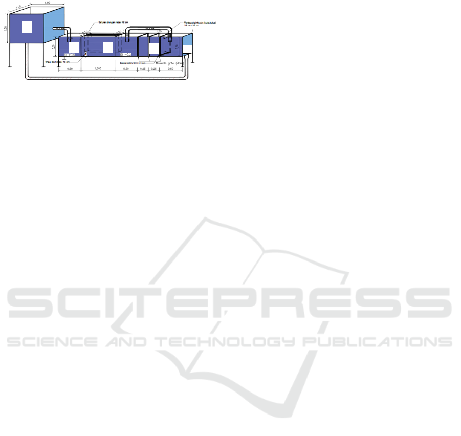
Figure 3: Scheme of Banger hydraulic polder simulation.
(A: Water reservoir; B: Catchment Area; C: Lang storage;
D: Pump; E: The Sea).
4 CONCLUSION
Flood and Rob occurred in the city of Semarang due
to the phenomenon of sea level rise and land
subsidence. Polder system to isolate seawater flow
and control water elevation with pumps, conduits,
ponds, embankments and weirs or gates. To
overcome this phenomenon must know the capacity
of Tonson, Pump and channel.
ACKNOWLEDGMENTS
Acknowledgments to RISTEKDIKTI for Research
Grant, Promoter and Co Promoter in this research and
PSDA Semarang city which has given place for
research.
REFERENCES
Wahyudi, S. I., 2010. “Perbandingan Penanganan Banjir
Rob Di La Briere ( Prancis ), Rotterdam ( Belanda ) Dan
Perspektif Di Semarang ( Indonesia )”, Jurnal Riptek,
Vol. 4, No. 2, pp. 29–35.
Nguyen, T. T. X., Bonetti, J. , Rogers, K. & Woodroffe, C.
D. 2016. “Indicator-based assessment of climate-
change impacts on coasts: A review of concepts,
methodological approaches and vulnerability indices”,
Ocean and Coastal Management, Vol. 123. pp. 18 – 43.
Wahyudi S. I., “Tingkat Pengaruh Elevasi Pasang Laut
Terhadap Banjir dan Rob di Kawasan Kaligawe
Semarang”, Jurnal Riptek, Vol. 1, No. 1, pp. 27–34.
Segeren, W. A., 1982. “Introduction to the keynotes of the
international symposium Polders of the World. In: Final
report of the international symposium Polders of the
World”, in International Symposium Polders.
Wahyudi, S. I., Ni’am, M. F. & Gilbert, L. B., 2012.
“Problems, Causes and Handling Analysis of Tidal
Flood, Erosion and Sedimentation in Northern Coast of
Central Java: Review and Recommendation”, Journal
of Civil and Environmental Engineering, Vol. 12, No.
4, pp. 65–69.
Pusair, P., 2007. Sistem Polder untuk Perkotaan Rawan Air,
Bandung, Indonesia.
Rosdianti, R., 2009. Banjir dan Penerapan Sistem Polder,
Jakarta, Indonesia.
Wahyudi, R. P. S. I., Heikoop, R., Adi, H. P., Overgaauw,
T., Schipper, B., 2017. “Emergency scenarios in the
Banger polder, Semarang City A case study to identify
different emergency scenarios”, Water Practice and
Technology, Vol. 12, No. 3, pp. 637–648.
Mah, D. Y. S., Putuhena, F. J. & Rosli, N. A., 2011.
“Modelling of river flushing and water quality in a
tributary constrained by barrages” Irrigation and
Draination System, Management of Environmental
Quality: An International Journal, Vol. 23, No. 1, pp.
101 – 108.
Taborda, R. & Ribeiro, M. A., 2015. “A simple model to
estimate the impact of sea-level rise on platform
beaches”, Geomorphology, Vol. 234, pp. 204 – 210.
Marfai, M. A. & King, L., 2008. “Tidal inundation mapping
under enhanced land subsidence in Semarang, Central
Java Indonesia”, Natural Hazardz, Vol. 44, No. 1, pp.
93 – 109.
Mondel, H., 2009. Conceptual Design Report. The CEPC
Study Group, Beijing, China.
Suripin, S., 2004. Sustainability Drainage System. Andi
Offset, Semarang, Indonesia.
Triatmodjo, B., 2008. Hidrologi Terapan. Beta Offset,
Yogjakarta, Indonesia.
A
B C
D
E
Simulation Plan Hydraulic Polder Banger System on the Flood of Rob City of Semarang
183
