
Physical Factor Analysis of Juata Laut Landfill’s Planning Location
in Tarakan City, North Kalimantan
Shinfi Wazna Auvaria
1
, Sarita Oktorina
1
, Widya Nilandita
1
and Sulistiya Nengse
1
1
Department of Environmental Engineering, UIN Sunan Ampel Surabaya
Keywords: Landfill Planning, Sanitary Landfill, Physical Factors, Juata Laut, Tarakan City
Abstract: The increasing amount of waste has an impact on the capacity of existing landfill in Tarakan City, North
Kalimantan. The land allotment is planned by the Regional Government of Tarakan City, covering an area of
40 Ha for the new landfill in Juata Laut sub-district, North Tarakan District. Juata Laut Landfill is planned to
use Sanitary Landfill system in accordance with Law No.18 of 2008, as well as an effort to minimize the
environmental impact and the realization of Sustainable Development Goals (SDG's) in solid waste sector.
The criteria for determining the location of the landfill consider the physical factors of landfill land planning
related to natural conditions. Physical factors analyzed in this study include climatology, geology, land type,
watershed, flood-prone areas, and topography (slope and land height). The methods used in this study are area
observation, collecting secondary data about the area of landfill planning, literature study, and making
comparisons with SNI 03-3241-1994. The analysis employed descriptive qualitative analysis. The results
indicate that the physical factors studied for Juata Laut Landfill are in accordance with the regulations and
provisions of the landfill planning with the sanitary landfill system.
1 INTRODUCTION
The increasing amount of solid waste in Tarakan City
has an impact on the existing landfill capacity that
cannot meet the needs for daily solid waste disposal.
Based on Tarakan City Spatial Plan No. 04 of 2012,
the TPA development is planned in Juata Laut Sub-
District, North Tarakan District. The Government of
Tarakan City provides a 40Ha landfill area.
New landfill that meets the standards of sanitary
landfill provisions is needed, because the existing
landfill still uses the Open Dumping system. Law No.
18 of 2008 requires all Landfills in Indonesia to be
managed by sanitary landfill. Sanitary landfill is a
system with lower environmental impacts compared
to other thermal processing (inseneration and
gasification), where gas produced from this system
can be used for fuel by controlling the emission
(Zaman, 2010). Environmental pollution from solid
waste can disrupt the comfort and health of the
community. Therefore, the planning of a new landfill
is important and urgently needed. Another goal of
planning is to manage solid waste disposed by the
population, as well as to achieve Sustainable
Development Goals (SDG's) in terms of solid waste.
The determination of landfill must follow the
terms and conditions set by the government. The
process of selecting landfill site consists of three
stages, namely the regional stage with decent and
unworthy regional outputs selected for the location of
the landfill, the selection screening stage determining
the most recommended location, and the
determination stage (Hasibuan, 2014).
Fulfillment of criteria to determine the location of
landfill should be able to minimize the impact of
environmental damage and pollution around the
landfill site because it considers many aspects of the
environment, health, and cleanliness, such as
geological conditions, springs, residential locations,
and locations of productive land (Maulidah, 2013). In
addition, the selection of landfill locations also takes
into account the physical factors of landfill planning
in relation to natural conditions (Rainda, 2017).
Natural conditions that are considered in the
physical factor analysis of landfill planning locations
include rainfall (climatology), geology, soil type,
watershed, flood-prone areas, and topography (land
slope and land height). The analysis of physical
factors can be used as a major consideration in
determining the location of the new landfill with a
Auvaria, S., Oktorina, S., Nilandita, W. and Nengse, S.
Physical Factor Analysis of Juata Laut Landfill’s Planning Location in Tarakan City, North Kalimantan.
DOI: 10.5220/0008907700002481
In Proceedings of the Built Environment, Science and Technology International Conference (BEST ICON 2018), pages 219-225
ISBN: 978-989-758-414-5
Copyright
c
2022 by SCITEPRESS – Science and Technology Publications, Lda. All rights reserved
219
sanitary landfill system in Juata Laut Sub-District,
North Tarakan District.
2. METHODS
There are some method can give the good result,
overall we can use basic step to get initial condition
2.1 Qualitative Analysis
The methods used in this study are area observation,
collecting secondary data about the area of landfill
planning, literature study, and comparison study
based on SNI 03-3241-1994. The analysis used is
qualitative analysis in the form of descriptive analysis
by describing the data obtained through the field
observations and outlining and interpreting the data.
In other words, qualitative analysis was very clear
with regard to the situation or phenomenon existing
in the study area.
2.2 Research site
This research was conducted in Tarakan City which
is located between 3.399 North Latitude and 117.560
East Longitude. Specifically, the landfill location was
planned to be in Juata Laut Sub-District, North
Tarakan District. The location of landfill area
provided by the local government of Tarakan City is
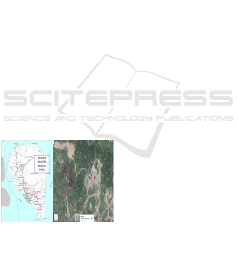
an area of 40 hectares. The planned area for the
development of Landfill location can be seen in figure
1.
Figure 1: Plan for the Development of Landfill Locations
in Tarakan City
3 RESULT AND DISCUSSION
Result and discussion will explain about all
condition on research.
3.1 Climatology
Weather condition is one of the factors that should be
considered in determining the location of the landfill.
Weather is a physical event that takes place in the
atmosphere at a certain time and place / space. The
weather will continue to change and differ between
other locations. This is influenced by several factors,
namely: altitude, latitude, spread of land and waters,
areas of high and low pressure, ocean currents,
atmospheric disturbances, or more weather and
climate (especially solar radiation) (Zetly, 2009)
Air temperature is determined by the height of the
place from the surface of the sea and the distance from
the beach. In general, Tarakan has a hot climate with
an average air temperature in 2015 reaching 24.8’C to
31.3’C. In addition, as a tropical climate, Tarakan
City has a relatively high average air humidity,
ranging from 56.0 percent to 98.0 percent throughout
2015. The lowest air humidity occurred in March
which only reached 47.0 percent. Meanwhile, the
highest air humidity occurred in June which reached
100 percent. The average air humidity throughout
2015 was recorded at 84.0 percent. Rainfall
somewhere is influenced by climatic conditions,
geographical conditions and velocity of air flow (BPS
Kota Tarakan,2017).
Therefore, the rainfall varies according to the
month and location of the observation station.
Rainfall in Tarakan City varies greatly from time to
time. The highest average rainfall which occurred in
November was 375.1 mm and the lowest average
rainfall was 197.4 mm which occurred in January.
The average rainfall during 2014 was recorded at
264.5 mm with an average rainy day of 20 days per
month. In addition to the climatological indicators
above, there are other indicators such as solar
radiation where the average in 2015 was 56.3 percent.
The highest air pressure in Tarakan City in March was
1,013.5 mb with an average of 1,011.7 mb (BPS Kota
Tarakan, 2017).
Rainfall analysis is very important in determining
the location of the landfill because it greatly
influences the risk of flooding. According to the SNI
BEST ICON 2018 - Built Environment, Science and Technology International Conference 2018
220
Decree, flood hazard parameters and rain intensity
parameters are different things. In the landfill site that
has relatively high rainfall, the likelihood of flooding
will be higher, so that it will cause solid waste to
move and cause landslides. Landfill location should
be placed in a low rainfall area, so that the lower the
better for landfill site (Maatuil and Fibriani, 2016).
Based on the BPS data of Tarakan City in 2017,
the average rainfall is relatively low, So, this could be
the reason for the construction of the landfill site. the
smaller the intensity of the rain, the better the
construction of the landfill site is (Antonius Arik
Rumbruren, 2012). This is because if the rain
intensity is high, the risk of flooding is also greater.
Therefore, the construction of landfill sites should be
carried out in locations with low rainfall.
3.2 Geology of landfill locations
Geology is basically the study of the earth and the
phenomena that occur. In science, the the results of
geological survey discuss the earth-forming material
and all the processes that will occur both within the
earth and above the surface of the earth. Therefore,
the description of the geological conditions in the
planned area of a construction that will be built,
including reviewing the dangers that will arise in the
development process, to provide information on the
level of security of the development results on a
construction and efficiency of costs will be used
during development takes place (Treman, 2014).
Most of Tarakan City consists of geological
elements in the form of units (TPQS) namely quartz
sandstone, clay stone, siltstone, lignite and
conglomerate. The composition of the geological
structure is spread in Tarakan City covering an area
of 16,058 Ha (64.03%) of the land area of Tarakan
City. Meanwhile, the rest is in the form of units (Qa),
namely mud, silt, sand, gravel and greed covering an
area of 9,022 Ha (35.97%) of Tarakan City’s land
area (BPS Kota Tarakan, 2017).
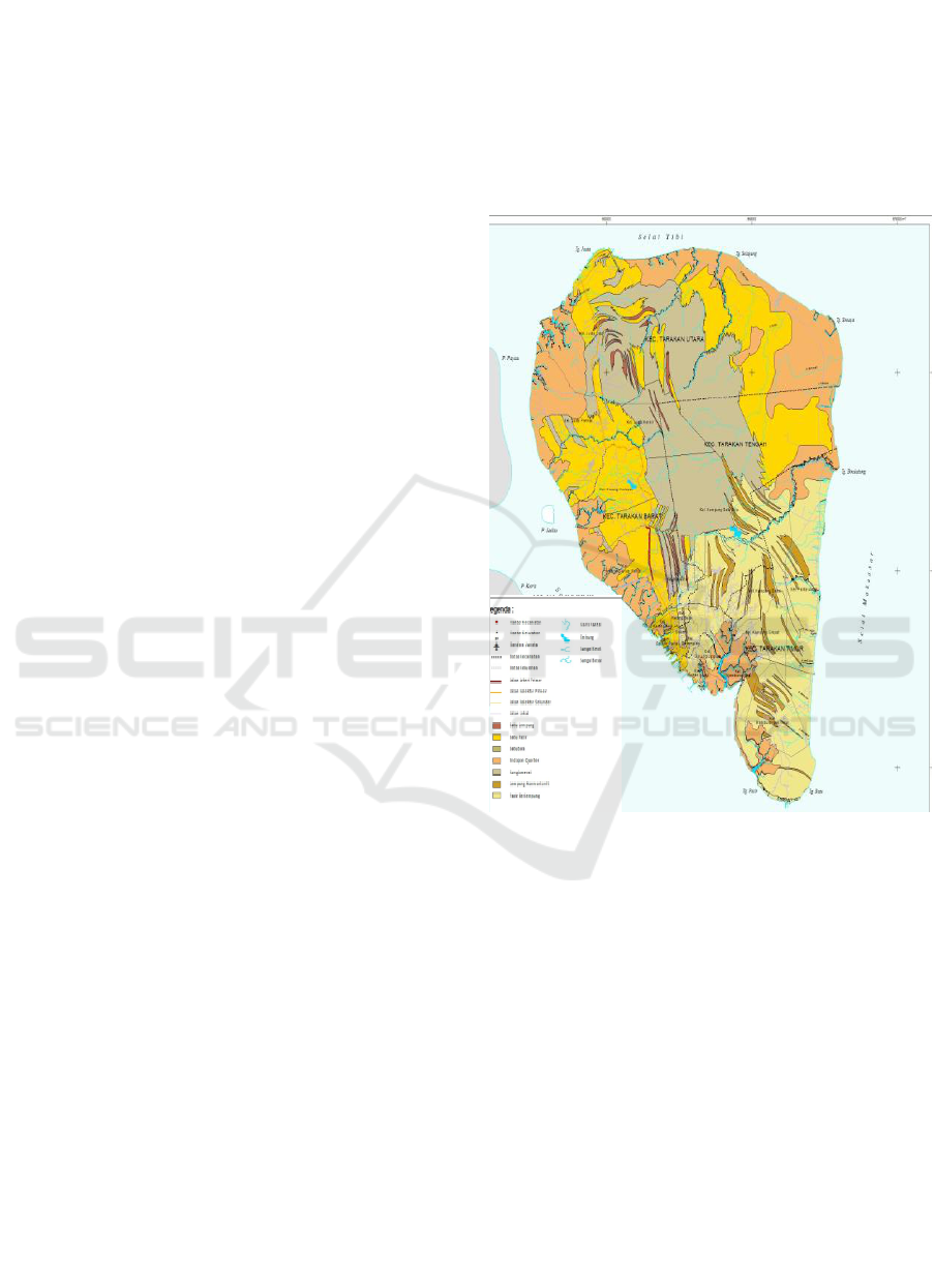
In general, the geological condition of Tarakan
City is in the form of hilly areas with wide lowlands.
Geological layers that exist in the city of Tarakan
generally are in the form of clay stones and are
followed by sandstone, coal, quarter sediment,
conglomerates, lemung montmorillonite, and clay
sand. The landfill area is an area with a land type in
the form of a conglomerate area (BPS Kota Tarakan,
2017)
Conglomerate rocks are one type of sedimentary
rocks formed from small particles that form
sedimentation. The conglomerate rocks are rough and
large textured. The composition of conglomerate
stones is derived from sand, gravel and soil. Besides
that, it also comes from weathering of rocks from
conglomerate rocks. Basically, conglomerate rocks
are not strong rock types. So, they cannot be used as
the foundation or structure of a building. However, if
the conglomerate rocks are destroyed, they can be
used as a support for the building. The geological
condition of Tarakan City can be seen in Figure 2.
Figure 2: Geological Conditions of Tarakan City
Geological location with soil conditions that are
quite hard are very desirable for Landfill. Usually,
clay or other compact rocks are considered feasible
for landfill locations. Hard/cracked or permeable hard
rocks will increase the potential for leachate that
spread outside landfill area (Damanhuri, 2008). It
means that geological condition in Tarakan City has
fulfilled the criteria for landfill location.
3.3 Soil type on landfill location
The condition of soil types is one of important factors
in the study of landfill planning. Land is a basic
material that is very important as the foundation
structure of buildings, highways, and others.
Damages of roads, buildings, and bumpy road
Physical Factor Analysis of Juata Laut Landfill’s Planning Location in Tarakan City, North Kalimantan
221
Aluvial
LEGEND
Latosol
Podsolik
Landfill
Location
surfaces are commonly caused by problems related to
the soil under the structure of a building (Gunarso
et.al., 2017).
Formation of land involves many processes, but
in general it can be divided into four parts, namely the
addition of material into the soil, loss of material from
the soil, changes in shape and displacement in solum
(from the top soil layer to the soil layer) (Iskandar,
et.al., 2017).
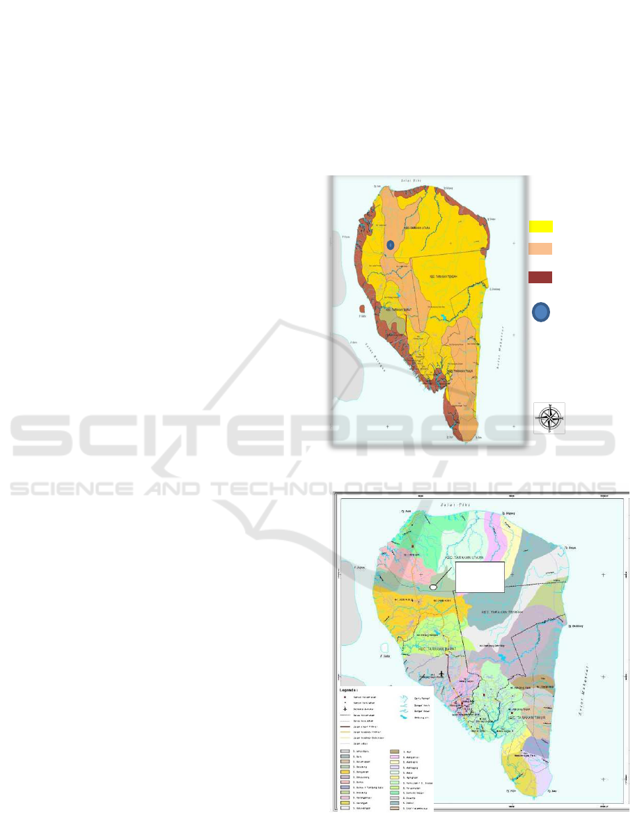
The dominant soil type in Tarakan City is the
latosol soil type in the central part of the island with
a few podzolic soil types, and the most abundant part
is the alluvial soil type. The landfill area is an area
with podsolic soil type (BPS Kota Tarakan, 2017).
Podolic soil is a soil that has an argillic B horizon,
having a base kill. Podolic soil has the broadest
distribution in Indonesia compared to other types of
soil. Podsolic soil is part of ultisol soil. According to
the USDA (United States Department of Agriculture),
ultisol is soil that has been washed.
One of the characteristics of podzolic soil is that
it has a very low nutrient storage capacity so that it is
not suitable for agriculture. Thus, it is classified as
infertile soil, both physically and chemically (Basuki,
2009).
In addition, there are several factors that affect
land conditions, including land productivity and land
status. The more unproductive the land, the better it is
in doing the development, such as landfill (Zetly,
2009).
The land area of Tarakan City with an area of
25,080 Ha is largely unused and is still in the form of
thickets (34%). The next largest land use is a mixture
of shrubs with agricultural cultivation in the form of
lading and moor (31.79%). Meanwhile, the urban
built area is only 6.1% of the total land area of
Tarakan City which is an area of 1.376 Ha. This
shows that the soil conditions in Tarakan City include
unproductive soil conditions (BPS Kota Tarakan,
2017).
The soil types of landfill location in Tarakan City
are shown in figure 3. From figure 3, it can be seen
that most of Tarakan City is dominated by Latosol.
The second largest area is Podsolik, followed by
Aluvial type.
Assessment criteria according to SNI 03-3241-
1994 based on the productivity aspects of landfill
land, the lower the productivity of the land, the better
the land is used for landfill. It means that based on the
soil criteria, this area is good for landfill site.
3.4 Watershed
There are twenty-four watersheds in Tarakan City
area, with 2 types of rivers, namely large rivers and
small rivers. The watershed in Tarakan City is very
crucial because the river is a source of raw water for
freshwater in Tarakan City. Map of the location of the
watershed (Watershed) of Tarakan City can be seen
in figure 4.
Figure 3: Land Type of Tarakan City
Landfill
Location
Figure 4: Map of Watershed in Tarakan City
BEST ICON 2018 - Built Environment, Science and Technology International Conference 2018
222
Based on Figure 4. the location of Juata Laut
landfill is in Baru Watershed. The distance of Juata
Laut Landfill to the nearest river is the small river
flow towards the sea. It is quite close to the landfill
site area. This must be considered, though this river is
not used as a water source. That was considered,
because landfill location should not be close to water
source (Maatuil and Fibriani, 2016). In landfill
location, there is also a flooded swamp source. This
must be considered in developing the landfill later.
3.5 Flood Risk Area
Some areas in Tarakan City are identified as flood-
prone areas, and there is a possibility that this flood
disaster will have an impact on the solid waste
collection process, so that transportation engineering
on solid waste is needed. The landfill plan area is safe
from the threat of flooding. Map of the potential
locations of flood disaster in Tarakan City can be seen
in figure 5.
Figure 5: Map of the potential locations of flood
disaster in Tarakan City
The assessment criteria from the aspect of
flooding is that landfill land which has a low risk of
flood is considered better than landfill land that has a
high risk of flood. This is related to the landfill
operational process, water pollution by leachate and
the possibility of solid waste that is being washed
away by the flood. This flood protection is carried out
up to a 25-year flood period.
Based on the condition of the landfill land, the
potential for flooding is relatively small. It can be
seen from the relatively hilly area and there is no
puddle area in this landfill land.
3.6 Topography
Tarakan City has flat to hilly topographic conditions.
There are hills longitudinal curved in Northwest –
Southeast direction with an altitude of about 110
meters above sea level.
The height of Tarakan City is classified into four
classes, namely 0-7 m asl, 7-25 m above sea level, 25-
100 m asl and > 100 - 110 m asl. Most of Tarakan
City is a flat area with an altitude of 25-100 m above
sea level with an area of 13,092 ha (52.20% of the
total area of Tarakan City). In height classification 7
- 25 m asl as wide as 8,940 Ha (35.65% from Tarakan
City).
3.6.1 Land slope
Almost 80% of Tarakan City area has a slope in steep
conditions. This condition must be taken into
consideration in planning the location of the landfill
because the topography of the landfill is steep. Land
slope is one of the main factors to determine possible
locations for landfill. The slope is closely related to
the ease of construction work and Landfill operations.
More steep area will result in difficulties in
activities/work of construction and operation (Irawan
dan Yudono, 2014).
Land use for functional areas such as built areas
requires land with a slope below 15%, while the land
with slope above 15% will be very suitable for the use
of plantations, tree crops and forests. Tarakan City
area has a dominant land slope from 0 - 5%, so that it
is quite good for landfill area. Map of the land slope
of Tarakan City is shown in figure 6.
Physical Factor Analysis of Juata Laut Landfill’s Planning Location in Tarakan City, North Kalimantan
223
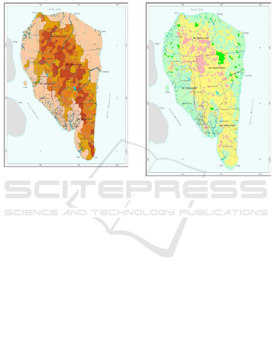
Figure 6: the land slope map of Tarakan City
The assessment criterion of the slope aspect of
landfill area is that landfill land that has a sloping
slope is considered better than land that has steep
slopes. The constructed landfill is also expected not
to be located in areas that has landslide potential or in
high soil movement vulnerability zones. This is
closely related to the protection against the possibility
of land sliding or landslides. The permissible
tolerance of slope is between the range 0-5%, 5 - 10%
and 10 - 20%, or the slope of the zone must be less
than 20%. Juata Laut landfill has a relatively steep
slope, because of the shape of the landfill site which
has a height difference that is relatively large and
steep.
3.6.2 Land Height
Tarakan city has a flat land contour pattern, where the
highest area in Tarakan City only has a height of ±
87.5 meters above sea level and the lowest area is 0-
25 masl. The landfill plan has an elevation of 50-90
masl. The height of Tarakan City area can be seen in
Figure 7. The land height in Tarakan City (plan area)
is quite good for landfill site, considering its location
which is far from residential area.
Figure 7: Height Map of Tarakan City
4 CONCLUSIONS
Based on the results of the analysis of physical factors
from the location of Juata Laut landfill plan area,
several point can be concluded
1. The climatology factors in Tarakan City quite
vary. Considering the temperature (24,8-31,3
Celcius degree) and average rainfall (264,5mm),
the landfill area is still possible to be developed in
this area.
2. Tarakan City is in the form of hilly areas with
wide lowlands. The The distance of Juata Laut
Landfill to the nearest river is the small river (not
used as a water source) that flows towards the sea.
It is quite close to the landfill site area.
3. landfill area is an area with a land type in the form
of a conglomerate area.
4. Landfill area is an area with polycolic soil type
and soil conditions in Tarakan City including
unproductive soil conditions.
5. The potential for flooding is relatively small,
which can be seen from the relatively hilly area
and there is no puddle area in this landfill land
6. Juata Laut landfill has a relatively steep slope,
because of the shape of the landfill site which has
BEST ICON 2018 - Built Environment, Science and Technology International Conference 2018
224

a height difference that is relatively large and
steep. It has flat land contour pattern, where the
highest area in Tarakan City only has a height of
± 87.5 meters above sea level and the lowest area
is 0-25 masl. The landfill plan has an elevation of
50-90 masl.
7. The results of the analysis show that the aspects
of physical factors for Juata Laut Landfill are in
accordance with the regulations and provisions on
the landfill planning with the sanitary landfill
system.
REFERENCES
Antonius Arik Rumbruren1, Raymon Ch. Tarore,2 &
Amanda Sembel. 2012. Evaluasi Kelayakan Lokasi
Tempat Pembuangan Akhir Sampah di Kecamatan
Manokwari Selatan,Universitas Sam Ratulangi.
Badan Pusat Statistik Kota Tarakan.2018.
Basuki. 2009. Evaluasi Status Kesuburan Tanah Podsolik
Merah Kuning Pada Beberapa Desa Di Kabupaten
Kotawaringin Barat, Kalimantan Tengah. Jurnal
AGRIPEAT, Vol.10 No.2, September 2009: 87-93.
Damanhuri, Enri.2008. Diktat Landfilling Limbah. Institut
Teknologi Bandung.
Dinas Pekerjaan Umum. SNI 03-3241-1994. Tata Cara
Pemilihan Lokasi TPA Sampah.
Gunarso, A., Nurprayogi, R., Partono, W. 2017. Stabilisasi
Tanah Lempung Ekspansif Dengan Campuran
Larutan NaOH 7,5 % . JURNAL KARYA TEKNIK
SIPIL, Volume 6, Nomor 2, Tahun 2017, Halaman
238-245 Online di: http://ejournal-
s1.undip.ac.id/index.php/jkts
Hasibuan, Putra Amantha., Tarigan, Ahmad P.M.,
Nasution, Z.P. 2014. Studi Pemilihan Lokasi
Tempat Pembuangan Akhir (TPA) Sampah Dengan
Metode Sistem Informasi Geografis (Sig) Di Kota
Tebing Tinggi. Jurnal Teknik Sipil Universitas
Sumatera Utara.
Irawan, Agus, B. dan Yudono, Andi, R.A. 2014. Studi
Kelayakan Penentuan Tempat Pemrosesan Akhir
Sampah (TPA) di Pulau Bintan Propinsi Kepulauan
Riau. Jurnal Ilmu Lingkungan, Vol.12 (1) : 1-11,
ISSN:1829-8907.
Iskandar, VO., Priadi, Eka., Aswandi. 2017. Perilaku
Pengembangan Tanah Lempung Akibat
Pengurangan Beban Di Bangunan Benua Indah
Pontianak.Jurnal Mahasiswa Teknik Sipil
Universitas Tanjungpura. Vol.4, No.4.
Maatuil, Kardia Ivana dan Fibriani, Charitas. 2016. Analisis
dan Pemetaan Lokasi Tempat Pembuangan Akhir
dengan Sistem Informasi Geografis dan Metode
Simple Additive Weighting. Program Studi Sistem
Informasi. Fakultas Teknologi Informasi
Universitas Kristen Satya Wacana. Salatiga.
Maulidah, Siti. 2013. Pemilihan Lokasi Tempat
Pembuangan Akhir (TPA) Sampah Kabupaten
Bangkalan dengan Bantuan Sistem Informasi
Geografis (SIG). Skripsi, Jurusan Geografi,
Fakultas Ilmu Sosial. Universitas Negeri Malang.
Rainda, Nina. 2017. Analisis Penentuan Lokasi Tempat
Pembuangan Akhir (TPA) Di Kabupaten
Temanggung Menggunakan Aplikasi Sistem
Informasi Geografis. Program Studi Geografi
Fakultas Geografi Universitas Muhammadiyah
Surakarta
Treman, I Wayan. 2014. Geologi Dasar.Penerbit Graha
Ilmu.
Undang-Undang Republik Indonesia Nomor 18 Tahun
2008 tentang Pengelolaan Sampah, Direktorat
Jenderal Peraturan Perundang-undangan.
United States Department of Agriculture. Natural
Resources Conservation Service. Soil Survey Staff.
.1999. Soil Taxonomy A Basic System of Soil
Classification for Making and Interpreting Soil
Surveys. Agriculture Handbook.Number 436.
Zaman, U.,A. 2010. Comparative Study of Municipal Solid
Waste Treatment Technologies Using Life Cycle
Assessment Method, Int.J.Environ.Sci.Tech.,7 (2),
hal.225-234.
Zetly,Tamod,E. 2009. Tingkat Kelayakan Lahan TPA
Sampah Kota Manado dalam Ukuran Mitigasi
Perencanaan Lokasi TPA. Jurnal Jurusan Tanah.
Fakultas Pertanian, Universitas Sam Ratulangi,
Manado.
Physical Factor Analysis of Juata Laut Landfill’s Planning Location in Tarakan City, North Kalimantan
225
