
Slums Degree in Densely Populated Settlements in the River of
Kapuas, Pontianak, as Sensitive Water Area
Eva Ryanti
1
, Nunik Hasriyanti
1
and Ismail Ruslan
2
1
Civil Engineering Department,Politeknik Negeri Pontianak, Ahmad Yani Street, Pontianak City, Indonesia
2
Department of Urban Design , Politeknik Negeri Pontianak, A. Yani Street, Pontinak City, Indonesia
3
Department of Sociology, IAIN Pontianak, A. Yani Street, Pontinak City, Indonesia
Keywords: Settlement, River Area, Slums, Water Sensitive Area, Waterfront.
Abstract: The growth of residential areas and settlements that are less livable in the riverside area of Pontianak City,
has an impact on the tendency of developing slum environment that is not in accordance with healthy living
standards. The socioeconomic condition of the low income earners, the unavailability of public facilities and
infrastructure, and the unofficial status of the land, have caused more slum settlements. The objectives of the
study were to identify the causes of slum factors and to analyze the dominant factors of slum. Obtained from
descriptive study approach with literature study technique and field survey, primary data and secondary data
were analyzed quantitatively and scored as to formulate aspects that caused slum dwellings in densely
populated settlements on the banks of the Kapuas River, especially in Sub-district of Benua Melayu Laut. The
conclusion is that the causal factors in the settlement area of Kelurahan Benua Melayu Laut are population,
residential building condition, condition of infrastructure and basic facilities, socio-economic condition.
1 INTRODUCTION
The essence of urban area planning based on the
principles of sustainability is an important role in
producing quality of urban built environment that is
able to attract the care of residents and citizens of the
city, and able to provide comfort for activities.
Implementation of a responsive environment in the
context of the urban environment can be explained as
follows: The existence of places and spaces for urban
activities, such as living, working, recreation, that
provides security for every citizen, the Environment
and urban areas that must have a good identity and
identity to develop a sense of togetherness and to have
a sense of belonging, the Environment and urban
areas that must offer opportunities, imaginations of
images and excitement / joy for every citizen, and the
Urban Environment that must be able to give meaning
to every citizen (design for all) and be able to offer a
place to live decently and well. This study will
discuss the condition of slums in settlements in the
Benua Melayu Laut Village.
2 METHOD
The research method used is field observations to
obtain an overview of the conditions, characteristics,
and formulation of issues related to water issues in the
settlement area of the Kapuas river bank. Secondary
data is obtained through literature studies and related
agency surveys. The analytical method used is
qualitative descriptive analysis and interviews with
relevant stakeholders, namely the Head of Benua
Melayu Laut Village.
3 RESULTS AND DISCUSS
Benua Melayu Laut Village (BML) is 0.50 above sea
level and is a riverbank area prone to flooding, with
an area of 13.13 Ha / 1.31 Km2. The boundaries of
the north is with Darat Sekip Village, Pontianak City,
the south is with the Bansir Laut Village in Southeast
Pontianak, the west is with Benua Melayu, South
Pontianak, and the east is with Tambelan Village,
East Pontianak. Keluran BML has 11 government
personnel. Total number of RW is 11 and number of
RT is 41. The population of BML is 10,282 people,
Ryanti, E., Hasriyanti, N. and Ruslan, I.
Slums Degree in Densely Populated Settlements in the River of Kapuas, Pontianak, as Sensitive Water Area.
DOI: 10.5220/0008905100002481
In Proceedings of the Built Environment, Science and Technology International Conference (BEST ICON 2018), pages 163-166
ISBN: 978-989-758-414-5
Copyright
c
2022 by SCITEPRESS – Science and Technology Publications, Lda. All rights reserved
163
consisting of 5,162 men and 5,120 women, with a
population density of 1800 people / ha.
Data on potential of the village were obtained
from the profile of BML Village. The village has
educational facilities that are 1 kindergarten and 2
elementary schools. There is no Junior High School
and Senior High School in the village. Places of
worship in the village are 5 mosques, 7 musalla(s), 1
church, and 1 temple. Meanwhile, there are 3 units of
health center, 6 units of posyandu (integrated service
post), 5 medical practitioners, 6 pharmacies, and 1
drug store. The number of public sanitation facilities
is 0 unit, public rainwater storage for 1003 families, 1
public hydrant, PDAM for 984 households, other
sources for 794 households. The following will
explain the analysis results of the level of slums in
Benua Melayu Laut Village.
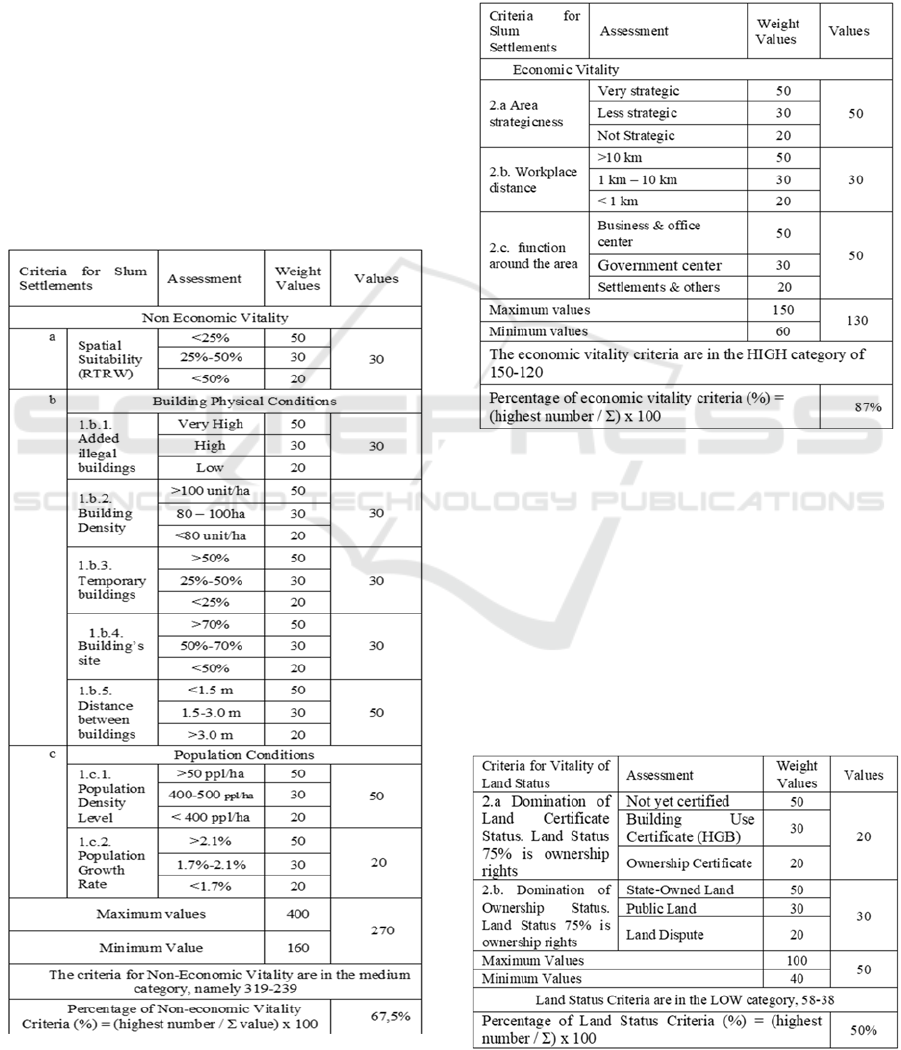
Table 1: Quality of Non Economic Vitality Criteria.
Source: Results of Analysis, 2018.
Based on the analysis of the value of slums level in
terms of Non-Economic Vitality Criteria, it can be
concluded that the value of slums was 270, and the
percentage of slum values from the entire study area was
67.5%. Because the value of 270 was in between 319-239,
the value of the degree of slums was categorized as medium
slum.
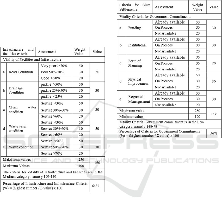
Table 2: Quality of Infrastructure Criteria and Facilities.
Source: Results of Analysis, 2018.
Based on the analysis of the value of slums level
in terms of Economic Vitality Criteria, it can be
concluded that the value of slums was 130, the
percentage of slum values from all study areas,
namely BML, was 87%. Because the value of 130
was inbetween 150-120, the value of the degree of
slums was categorized as high slum. The degree of
integrity was reviewed from the criteria of economic
vitality.
Table 3: Analysis of the degree of slum that is rated based
on the criteria for the status of soil vitality.
BEST ICON 2018 - Built Environment, Science and Technology International Conference 2018
164
Based on the analysis of the slums level which
was viewed from the Criteria of Land Status, it can be
concluded that the value of slums was 50 and the
percentage of slum values from all study areas was
50%. Because the value of 50 was in between 58-38,
the degree of slums was categorized as low slum. The
degree of integrity was reviewed from the Land
Status criteria.
Table 4: Quality of Infrastructure Criteria and Facilities.
Based on the analysis of the value of the slums
level in terms of the Infrastructure Criteria and
facilities, the value of the slum of 160 was obtained.
The percentage of slum values from all study areas,
witch is Kelurahan BML, was 64%. Because the
value of 160 was in between 199-149, the value of the
degree of slums was categorized as medium slum.
The degree of integrity was reviewed from the criteria
of infrastructure and facilities.
Based on the analysis of the slums level which is
viewed from the Criteria for Land Status, it can be
concluded that the value of slums was 140, and the
percentage of slum values from all study areas is 56%.
Because the value of 140 was in between 148-98, the
value of the degree of slums was categorized as low
slum. The value of this degree of integrity was reviewed
from the criteria of Government Commitment.
Table 5: Analysis of Calculation of Degrees of Slum Levels
Reviewed From Government Commitments.
Based on the analysis of the value of the slums
level in terms of the Priority Handling Criteria, the
slum value of 460 was obtained, and the percentage
of slum values from all study areas was 92%. Because
the value of 460 was in the range between 500-400,
the degree of slums was categorized as high slum.
The degree of severity was reviewed from the Priority
Handling criteria.
4 CONCLUSIONS
Results of Weighting Criteria for Slum Settlement
Areas in Benua Melayu Laut Village, South
Pontianak Subdistrict concluded that from the six
criteria for weighting slum areas in Benua Melayu
Laut Village, the highest priority criteria for handlers
with a percentage of 90% illustrates that this criterion
has a very large impact on increasing slums in Melayu
Laut Village While in criteria for land qwnership
status with a percentage of 50% (lowest) indicate a
low level of slum. It means that most people in the
Kelurahan Benua Melayu Laut already have land that
has certification for ownership.
Slums Degree in Densely Populated Settlements in the River of Kapuas, Pontianak, as Sensitive Water Area
165

ACKNOWLEDGEMENTS
We would like to thank Ministry of Research,
Technology and Higher Education for funding
assistance from the Decentralized Research Scheme
of Higher Education Applied Research Schemes in
2018.
REFERENCES
Budihardjo, Eko. 1994. Arsitektur & Kota di Indonesia.
Bandung: Penerbit Alumni.
Coffman, Larry. 2000. Low-Impact Development Design
Strategies, An Integrated Design Approach. EPA 841-
B-00-003. Prince George's County, Maryland.
Department of Environmental Resources, Programs
and Planning Division.
Committee on Reducing Stormwater Discharge
Contributions to Water Pollution National Research
Council. 2009. Urban Stormwater Management in the
United States. National Academies Press.
Darsono, Susesno. (2007). Sistem Pengelolaan Air Hujan
Lokal Yang Ramah Lingkungan. Berkala Ilmiah Teknik
Keairan Vol. 13, No. 4-Desember 2007, ISSN 0854-
4549 Akreditasi Dikti No. 23a/DIKTI/KEP/2004.
EPA. 2000. Low Impact Development (LID) A Literature
Review. EPA-841-B-00-005, Washington DC 20460
October 2000.
Fiener, P. and Auerswald, K., (2005), 'Measurement and
modeling of concentrated runoff in grassed waterways',
Journal of Hydrology, Vol. 301, No. 1-4, pp. 198-
215.Howard, Ebenezer. 1989. To-Morrow: A Peaceful
Path to Real Reform. London: Faber and Faber.
Lokita, Aurora Dias. 2011. Adaptasi Konsep Water
Sensitive Urban Design (Wsud) Di Kawasan Cagar
Budaya Kota Lama Semarang. Jurnal Perencanaan
Wilayah dan Kota, Vol. 22 No. 1, April 2011, hlm.65 –
80.
Roychansyah, M.Sani. 2007. Water Sensitive Urban
Design. (http://saniroy.archiplan.ugm.ac.id/?p=335
diakses pada 20 Oktober 2009).
Shirvani, Hamid. 1996. Urban Design Process.
Winogradoff, A.Derek. 2001. The Bioretention Manual,
Programs & Planning Division, Department of
Environmental Resources Prince George's County,
Maryland.
Yunus, Sabari, Hadi. (2008). Dinamika Wilayah Peri
Urban. Pustaka Pelajar, Yogyakarta.
BEST ICON 2018 - Built Environment, Science and Technology International Conference 2018
166
