
Crustal Deformation Monitoring in Beijing Using Radarsat-2
InSAR Time Series Analysis
L Y Hu
1,*
, Y S Li
2
, C Q Xing
1
, K R Dai
3,4
, R Yan
1
and X Guan
5
1
Beijing Earthquake Agency, China
2
Key Laboratory of Crustal Dynamics, Institute of Crustal Dynamics, CEA, China
3
College of Earth Sciences, Chengdu University of Technology, Chengdu, China.
4
State Key Laboratory of Geohazard Prevention and Geoenviroment Protection,
Chengdu University of Technology, China
5
The 29th research institute of CETC, China
Corresponding author and e-mail: L Y Hu, huleyin@bjseis.gov.cn
Abstract. The main aim of this study is to investigate the current vertical crustal movement
characteristics and evolution process in Beijing using InSAR technology. In this paper, the
InSAR time series analysis method was used to monitor the crustal deformation in Beijing
during the period from 2012 to 2015, and to quantitatively reveal the overall deformation
characteristics of different areas within the study area. Based on 33 Radarsat-2 wide-mode
SAR images covering Beijing, 68 interferograms were formed by optimizing the combination
of baselines. Using the FRAM-INSAR technique, the cumulative deformation time series and
images along the line-of-sight of the satellite in the 32-phase period were calculated, and the
annual average deformation velocity field in Beijing and neighbouring areas during 2012-
2015 was calculated. Based on the distribution of active structures in the study area and the
distribution of ground subsidence, the relationship between the deformation characteristics of
the entire crust and the tectonic activity and land subsidence in the study area was discussed,
which provided an effective criterion for accurately carrying out seismic risk assessment in
this area.
1. Introduction
As China’s political center, cultural center, international exchange center and scientific and
technological innovation center, Beijing has developed rapidly in recent years in economic, social
development and urban construction. However, with the rapid development of economy and urban
construction, land subsidence has gradually developed into one of the major geological hazards in
Beijing and even in the entire North China Plain. This has caused certain negative impacts on
Beijing’s urban development. Its potential harm has been increasingly concerned by the society and
the government [1,2]. Since 2002, the Beijing Municipal Government has increased its investment in
enhancing the monitoring capabilities on the urban land subsidence. With the completion of Beijing's
land subsidence early warning and forecasting system, a ground subsidence monitoring system
consisting of ground subsidence monitoring stations, ground level monitoring networks, GPS
monitoring networks and groundwater dynamic monitoring networks has been gradually formed [3].
710
Hu, L., Li, Y., Xing, C., Dai, K., Yan, R. and Guan, X.
Crustal Deformation Monitoring in Beijing Using Radarsat-2 InSAR Time Series Analysis.
In Proceedings of the International Workshop on Environmental Management, Science and Engineering (IWEMSE 2018), pages 710-717
ISBN: 978-989-758-344-5
Copyright © 2018 by SCITEPRESS – Science and Technology Publications, Lda. All rights reserved

At the same time, Beijing is also a region where the tectonic movement is more active. Since the
late Cenozoic era, there have been three active vertical tectonic zones (stripes) with strong
differential faults. They are the NE-trending North China Plain fault zone, the Shanxi fault
depression basin zone, and the Zhangjiakou-Bohai structural belt that is superimposed on the NW-
wise extension of the northern part of these two zones and the southern margin of the Yanshan
Mountains [4]. The seismic and geologic environment in the area is complex. The activities of the
new structure are intense and the active faults are developed. It is one of the regions with the most
severe earthquakes and the most serious earthquake disasters in the eastern part of China's mainland.
Historically, there have been many major earthquakes in the area, such as the magnitude 8.0
earthquake in Sanhe-Pinggu and many over magnitude 5.0 earthquake [5]. Strengthening the
monitoring and research on the features of crustal movement and fault activity in this area is of great
significance for the prevention and relief of disasters in the region.
In recent years, more and more research teams have begun to pay attention to the phenomenon of
land subsidence in Beijing. A variety of crustal deformation observation methods, such as leveling,
GPS, and InSAR, are used for ground subsidence monitoring in the area. Among these observation
technologies, InSAR technology as a kind of surface deformation monitoring of the rapid
development of the technology, with its high monitoring precision, wide coverage, the application of
low cost, short repeated cycle of advantages, is widely used in the ground deformation monitoring [6].
Land subsidence due to over-extraction of groundwater in the Beijing region was investigated using
41 Envisat ASAR and 14 TSX images and the results reveal that the Beijing region has experienced
significant ground subsidence from 2003 to 2010 with a maximum accumulative displacement of 790
mm [7]. As the same method, Land subsidence from 2003 to 2014 due to groundwater extraction in
Beijing plain was detected based on 39 ENVISAT ASAR images and 27 RadarSat-2 images using
PS- InSAR, which showed that the land surface in Beijing plain area is settling at an accelerating rate,
and the accumulative displacement is up to 1426 mm along the LOS by the end of 2014 [8]. Based on
A multi-layer numerical groundwater flow model, an aquifer system of Beijing plain has been
developed to accurately describe the characteristics of the groundwater flow field [9]. A Wavelet
Based InSAR approach on two SAR image stacks was implemented to investigate the long-term
displacement in eastern Beijing Plain and found that the Land subsidence in Beijing Plain has
connection with hydraulic head level falling caused by over-exploitation of groundwater [10].
Based on the above research progress, there are still some problems as following:
1) Most studies focused on the relationship between land subsidence and groundwater
Overexploitation, without considering the context of the geological structure and the relationship
between fault activities.
2) Most of the studies focused only on the subsidence areas in the plain area and did not cover the
mountainous areas, which could not explain the overall movement characteristics of the whole area.
3) Due to the fact that there are few wide-range radar satellite data available during the period
2012-2015, most studies are based on high-resolution SAR images such as TerraSAR-X, which
limits the ability to acquire large-scale deformation signal.
In this paper, INSAR time series analysis method based on 33 Radarsat-2 wide SAR imagery
from 2012 to 2015 were used to obtain large-scale dynamic deformation time series and mean
deformation velocity field in Beijing. Based on these results, the information of the overall vertical
deformation in Beijing during this period was calculated, and the trend of land subsidence in the area
and its relationship with fault activity were analyzed.
Crustal Deformation Monitoring in Beijing Using Radarsat-2 InSAR Time Series Analysis
711
2. Study area and data
2.1. Study area
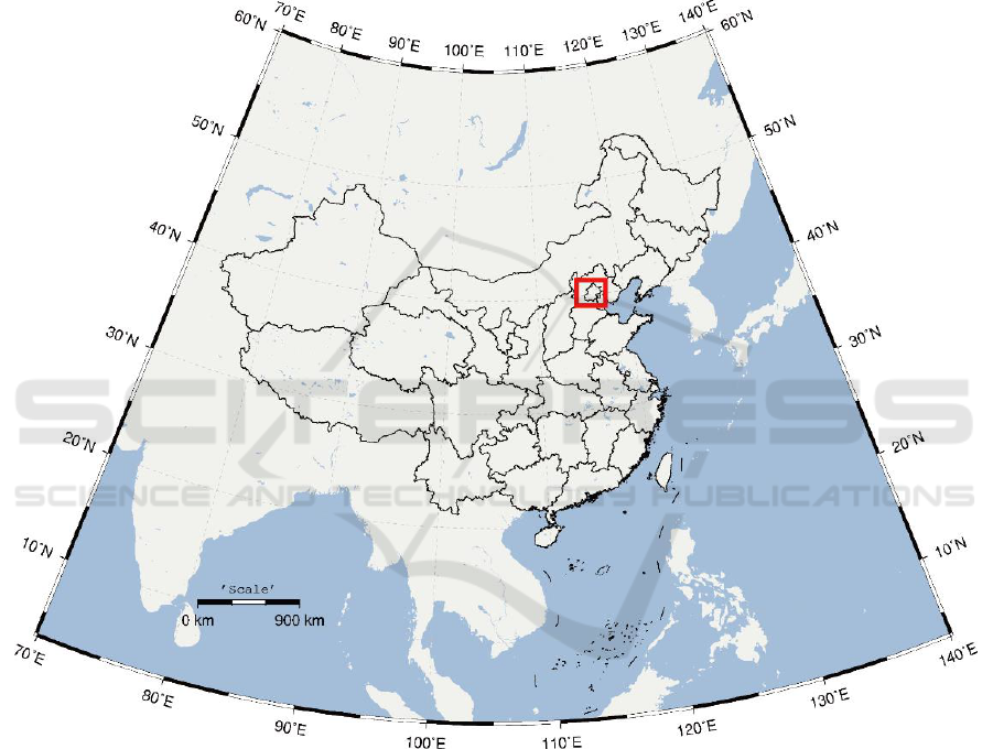
The research area of this study is in Beijing and its adjacent areas (115°E~118.2°E, 38.8°N~41°N),
which is located at the junction of the North China Plain and the Taihang Mountains and the Yanshan
Mountains. The southeastern part of this area is plain and belongs to the northwestern fringe of the
North China Plain; The western mountainous region is the northeastern part of the Taihang
Mountains; The northern and northeastern mountainous region is the western branch of the Yanshan
Mountains (Figure 1).
IWEMSE 2018 - International Workshop on Environmental Management, Science and Engineering
712
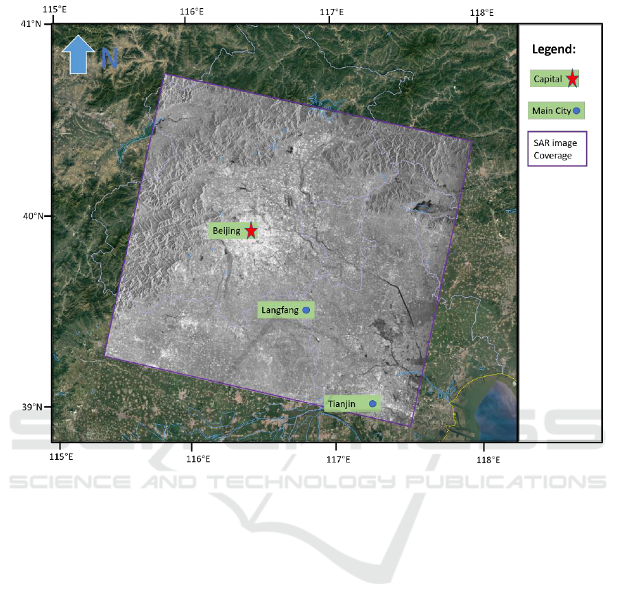
Figure 1. Location of the study area and the coverage of SAR images.
Since 1950, a large area of land subsidence has continued to occur as a severe geological disaster.
By the end of 2005, the area of ground settlement greater than 50 mm reached 4114.12 km2, and the
area greater than 100 mm reached 2815.29 km2. Settlement amount reaches 1086mm, and the most
serious area is still sinking at a speed of 30~60mm/year. The maximum average settlement speed
reaches 66.3mm/year [11]. By the end of 2009, the maximum annual settling speed reached
137.51mm [12,13]. Land subsidence has brought major losses to Beijing's social economy. The
results of the study show that 34% of broken water supply pipelines in urban areas in Beijing were
caused by land subsidence [14].
2.2. Data
In this paper, we used 33 Radarsat-2 wide SAR images range from the year 2012 to 2015 covering
most of Beijing area to acquire the crustal deformation along the line of sight (LOS) direction. All the
SAR images were imaged in wide mode with the VV polarization mode. The coverage of the
Radarsat-2 SAR images is shown in figure 1.
In the process of data processing, in order to maintain good interference coherence and to ensure
the reliability of the interference results, the Small Baseline Subset (SBAS) algorithm must be used
to select the time baseline and space baseline when combining the interference pairs. In this study,
the spatial baseline threshold was chosen to be ±200m and the time baseline threshold was ±300 days.
To ensure the stability of the mesh, some interference pairs with the baseline of the time was slightly
Crustal Deformation Monitoring in Beijing Using Radarsat-2 InSAR Time Series Analysis
713
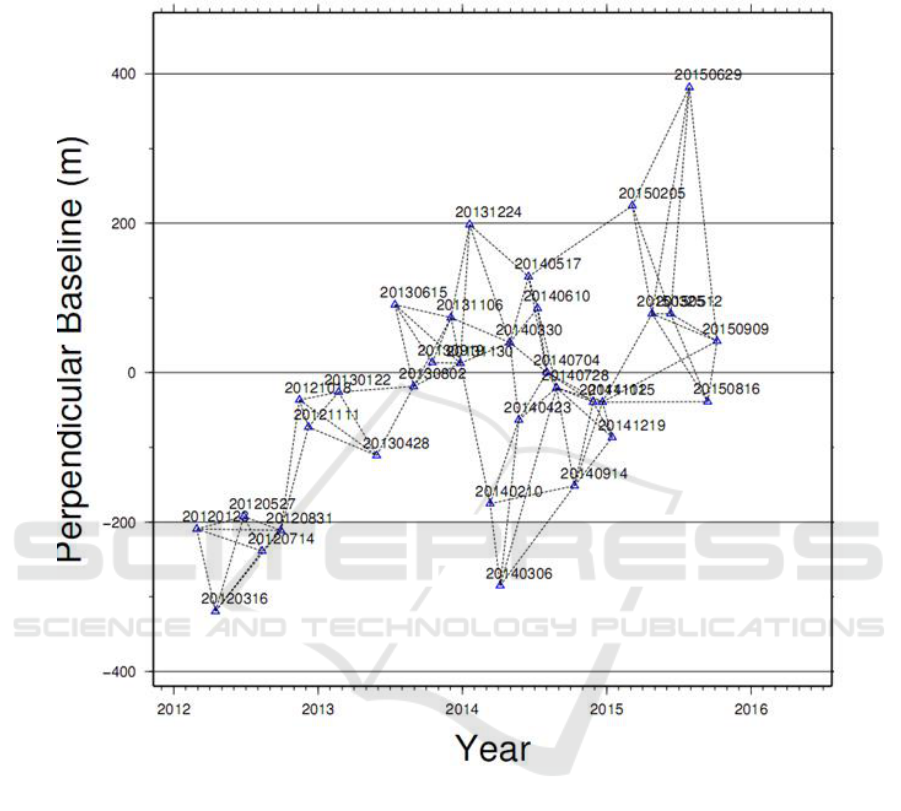
longer than the baseline threshold and the vertical baseline was small. Finally, 47 interferograms with
high interference quality are obtained. The combined network diagram is shown in Figure 2.
Figure 2. Spatial and temporal baselines of Radarsat-2 SAR images used in this study.
In the data processing process, in order to remove the topographic phase in the interferometric
phase, the SRTM-DEM data SRTM3 (3 arc-seconds) jointly measured by the NASA and the
National Mapping Agency of the Ministry of National Defence (NIMA) was selected as the external
DEM data, which is at the version of V4.1 and was publicly released in 2003. The data range is 38°-
40° north latitude and 109°-111° east longitude. Figure 3 shows the image of the DEM we used in
this study.
IWEMSE 2018 - International Workshop on Environmental Management, Science and Engineering
714

Figure 3. The DEM image we used in this study.
3. Data processing and results
Figure 4. The mean velocity field of crustal deformation along the line of sight (LOS)
direction from 2012-2015 derived from RADARSAT-2 WIDE mode SAR images.
Crustal Deformation Monitoring in Beijing Using Radarsat-2 InSAR Time Series Analysis
715
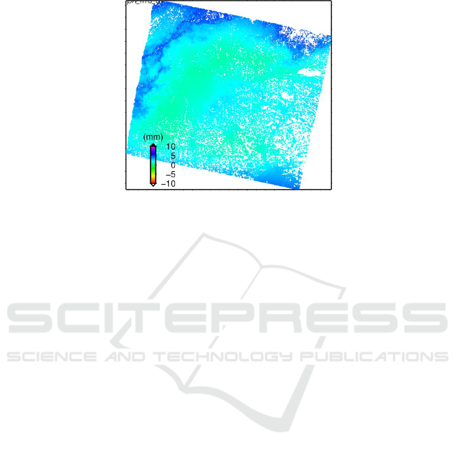
Figure 5. The error distribution of the mean velocity field.
The InSAR time series analysis was carried out by using the software named Full RAnk Matrix –
Small BAseline Subset (FRAM-SBAS) which was developed by Yongsheng Li in Institute of Crustal
Dynamics, CEA, China and Newcastle University, UK.
FRAM-SBAS is a multi-function processing platform based on Linux that includes radar
interferometric processing, time series analysis, and geometric correction. Currently supports all
global commercial SAR satellite platform data. The software is simple and easy to use, supports
process processing, and can be applied to the domain of urban land subsidence, co-seismic and post-
earthquake deformation analysis, volcano monitoring, landslide debris flow monitoring. The FRAM-
SBAS software is one of the most effective processing tools to solve the small deformation
monitoring of the crustal plate. The continuous improvement and innovation of new methods and
innovations have continuously improved and supplemented the SBAS theoretical model in different
aspects [15].
Based on the FRAM-SBAS software, we got the mean velocity field of crustal deformation along
the line of sight (LOS) direction from 2012-2015 in Beijing area. Figure 4 shows the final result of
the mean velocity field and figure 5 shows the error distribution of the mean velocity, which show a
good result with reasonable accurate.
4. Conclusions
Based on 33 Radarsat-2 wide SAR images, in this paper, we obtained the crustal deformation field
information covering the entire Beijing area, including the annual mean deformation velocity field
and 32 periods of accumulated deformation sequence images from 2012 to 2015. From the
calculation results, the following conclusions can be drawn:
1) The overall performance of the Beijing area showed a trend of slow mountain uplift and rapid
settlement in the plain area, among which the mountain uplift speed is relatively slow,
averaging around 1 mm/year; the main urban area (within the third ring) is relatively stable;
the eastern part has more serious settlement, and the largest velocity reaches 130mm/year.
2) The subsidence areas in Beijing are mainly distributed in the plain area. There are three more
serious areas, namely The Haidian-Changping-Shunyi area, the Chaoyang-Tongzhou border
area, and the Langfang area bordering Beijing.
3) Judging from the cumulative deformation evolution image, During the period of 2012-2015 in
Beijing where the three settlements are more serious, the trend of settlement has continued to
increase.
IWEMSE 2018 - International Workshop on Environmental Management, Science and Engineering
716

Acknowledgement
This research is funded by the project of the science for earthquake resilience (No. XH18001Y), the
Beijing financial project (No. DQXBSJ) and the Educational Commission of Sichuan Province of
China(15ZA0060)
References
[1] The Guardian, Beijing has fallen: China's capital sinking by 11cm a year, satellite study warns.
https://www.theguardian.com/world/2016/jun/24/beijing-has-fallen-chinas-capital-sinking-
by-11cm-a-year-satellite-study-warns
[2] Li S, Ye X, He Q, Fang H and She W 2006 Discussion on Economic Loss Assessment
Methods of Land Subsidence Disaster in North China Plain Hydrogeology & Engineering
Geology 2006(04):114-116
[3] Zhao S, Liu M, Zhou Y 2008 Monitoring Network of Land Subsidence in Beijing City
Geology 3 015
[4] Deng Q, Zhang P, Ran Y, Yang X, Min W and Chen L 2003 Active tectonics and earthquake
activities in China Earth Science Frontiers 10(SUPP) 66-73
[5] Zhu H, Xing C, Li H and Han K 2010 Segmentation of main seismic belts and strong
earthquakes in North China tectonic region J. Acta Seismologica Sinica 6 009
[6] Zhou Q, Zhao W and Yu J 2018 The Monitoring and Spatial -Temporal Evolution
Characteristic Analysis for Land Subsidence In Beijing. Int. Arch. Photogram Remote Sens.
Spatial Inf. Sci.
[7] Chen M, Tomás R, Li Z, Motagh M, Li T, Hu L and Gong X 2016 Imaging land subsidence
induced by groundwater extraction in Beijing (China) using satellite radar interferometry
Remote Sensing 8(6) 1–21
[8] Deng Z, Ke Y, Gong H, Li X and Li Z 2017 Land subsidence prediction in Beijing based on
PS-InSAR technique and improved Grey-Markov model GIScience and Remote Sensing
54(6) 797–818
[9] Qin H, Andrews C B, Tian F, Cao G, Luo Y, Liu J and Zheng C 2018 Groundwater-pumping
optimization for land-subsidence control in beijing plain, china Hydrogeology Journal
[10] Gao M, Gong H, Chen B, Li X, Zhou C, Shi M and Duan G 2018 Regional land subsidence
analysis in eastern Beijing Plain by InSAR time series and wavelet transforms Remote
Sensing 10(3) 1–17
[11] Zhang W, Gong H, Chen B and Duan G 2015 Evolution and Genetic Analysis of Land
Subsidence in Beijing Typical Area Journal of Geo-Information Science 17(8) 909-916
[12] Chen B, Gong H, Li X, Zhang Y, Dang Y and Song L 2011 Monitoring and Risk Analysis of
Land Subsidence in Beijing Based on Interferometric Synthetic Aperture Radar (InSAR)
Technique J. Geography and Geo-Information Science 2 005
[13] Yang Y, Jia S and Wang H 2010 The status and development of land subsidence in Beijing
plain Shanghai Geology 31(4) 23-28
[14] Jia S, Wang H, Luo Y, Yang Y, Wang R and Feng Y 2007 The Impacts of Ground Subsidence
on Urban Construction in Beijing City Geology 4 006
[15] Li Y 2014 Surface Deformation, Co-seismic and Post-seismic Activity Constrained by
Advanced InSAR Time Seiries Analysis Phd thesis Institute of Engineering Mechanics
Crustal Deformation Monitoring in Beijing Using Radarsat-2 InSAR Time Series Analysis
717
