
Lithospheric Electrical Characteristics of Eastern Jiangnan Orogen,
South China
Gengen Qiu
*
, Hui Fang, Qinyin Lv, Yan Pen, Dashuang He and Mexing He
Institute of Geophysical and Geochemical Exploration, Langfang 065000
Email: qiugengen@igge.cn
Keywords: Eastern Jiangnan orogeny, electrical characteristics, magnetotelluric sounding
Abstract: A large amount of mineral resources are distributed in the Southern China, which shows South China block
has experienced a complicated geological evolution process. Three dimensional (3D) lithospheric electrical
structure model of eastern Jiangnan orogen was established in this paper by 3D OCCAM inversion program.
The 3D lithospheric electrical structure model has a good corresponding relationship with the subsurface
geology and regional magnetic anomalies, and thus can provide more detailed information about
underground geological structure. From the perspective of 3D electrical structure model in combination
with regional geologic conditions and regional magnetic data, the eastern Jiangnan orogenic belt and
adjacent regions are divided into 4 first-order tectonic units and 16 secondary tectonic units. The 4 first-
order tectonic units include North China zone with low resistance, Dabie orogenic belt zone with high
resistance, Yangtze zone with low resistance and high-resistivity, and Cathaysia massif zone with high
resistance. The 3D model shows that layers and abnormal bodies with low resistivity in the crust and upper
mantle in the Southern China are widely developed. The characteristics of ‘U’ shape high resistance root in
the deep part of Dabie Mountains imply that the North China block and Yangtze block collided and
subducted beneath the Dabie Mountains on the north and south sides, suggesting strong compression uplift
tectonic settings. The overall performance of the Yangtze block is characterized by high resistance in the
middle and low resistance around. Huaiyu terrane located in the east of Yangtze block is of low resistance
characteristic, suggesting apparent obduction tectonic environment. Evidently the assaulted low resistance
anomalous in the lower section occurred along the collage tectonic belt, and these low resistance anomalous
could be related to the distribution and formation of a large amount of metal minerals above. The low
resistance anomalous whose tendency for south east along Jiangshao fault indicate the Cathaysia massif
obducted to Yangtze block. The establishment of 3D lithospheric electrical structure model of the eastern
Jiangnan orogen is to explore the relationships between different tectonic units and analyse the formation
and evolution of south China continent, which could have important reference value for forecasting and
prospecting of potential minerals.
1 INTRODUCTION
Southern China is composed of Yangtze block and
Cathaysia massif, which contains enrichment areas
of mineral resources in the mainland of China.
Stratigraphic sequence exposed in Southern China
spans from the Proterozoic to Cenozoic. Basic,
neutral and acidic igneous rocks are widely
distributed, especially Mesozoic granule volcanic-
intrusive rocks which are the most widely developed
(Dong and Ma, 2011). Southern China contains
abundant mineral resources, and various ores in
huge reserves. There are many metallogenic belts
distributed in the Southern China, such as the middle
and lower reaches of the Yangtze river metallogenic
belt and Qin-Hangzhou metallogenic belt. Its
distinctive geological pattern, unique crustal growth
and metallogenic regularity are rare in the
worldwide, suggesting a deep geodynamic
background and complicated tectonic evolution
history of the South China block. Nowadays, the
cause of abundant mineral deposits formation in this
metallogenic belt has been still a hot issue and have
attracted the attention of scholars of geologists.
Numerous geophysical prospecting works have
been carried out by predecessors in the Southern
China. After several generations of efforts, research
results are abundant, while there are still many basic
geological problems unsolved in the Southern China.
One of the simplest reasons is lack of knowledge
about deep geological information. Magnetotelluric
Qiu, G., Fang, H., Lv, Q., Pen, Y., He, D. and He, M.
Lithospheric Electrical Characteristics of Eastern Jiangnan Orogen, South China.
In Proceedings of the International Workshop on Environment and Geoscience (IWEG 2018), pages 415-420
ISBN: 978-989-758-342-1
Copyright © 2018 by SCITEPRESS – Science and Technology Publications, Lda. All rights reserved
415
(MT) sounding is one of the most important methods
for deep exploration (Chen and Liu, 1984), due to its
advantages in deep detecting, light equipment,
stationing flexibly, and low-cost. MT sounding is
widely used in the field of resource exploration and
deep structure study of crust and mantle. In order to
obtain deep structure information of the Southern
China, we carried out a large area of regional
magnetotelluric sounding work in the Southern
China during 2008-2016, and also completed a
measurement area of about 350 thousand square
kilometers. 525 wide-band magnetotelluric sounding
stations were acquired. At present, 1D and 2D
inversion methods of magnetotelluric data have been
developed, which have become the main means of
the actual data processing and interpretation (Dong
et al., 2012; Chen et al., 2011; Cai and Chen, 2010).
The nonlinear conjugate gradients algorithm
(NLCG) and the improved OCCAM method become
the mainstream inversion methods (Rodi and
Mackie, 2001; Rodi, 1976; Siripunvaraporn and
Egbert, 2000). With the development of 3D forward
calculation and the improvement of computer
performance, 3D magnetotelluric inversion method
is developing rapidly, and is gradually applied to
actual data processing (Newman and Alumbaugh,
2000; Patro and Egbert, 2008; TANG et al., 2014;
YANG et al., 2015; YANG et al., 2015; QIU et al.,
2014).
In this paper, we introduce the process of how to
construct 3D electrical structure model of eastern
Jiangnan orogen by WSINV3DMT inversion
program which is based on REBOCC 3D inversion
algorithm. Based on the analyses of 3D electrical
structure model, regional geology, regional gravity
and magnetic data, we have preliminarily divided
the tectonic units in the Southern China, and analyze
the electrical characteristics and contact relationship
of each structural unit. The 3D model provides
important information for the formation and
evolution of the mainland of Southern China and the
favorable direction of subsequent prospecting.
2 REBOCC INVERSION THEORY
Data-space method is proposed by professor
Weerachai Siripunvaraporn on the improvement of
Occam inversion algorithm (Siripunvaraporn et al.,
2004; Siripunvaraporn et al., 2005; Siripunvaraporn
and Egbert, 2009). It is based on the calculation and
storage format of the sensitivity function that
transform from original model space (M╳M) to
data space (N ╳ N) by derivation. The model
roughness is defined which can make the model
more flexible , and suppress the geoelectric structure
irrationality. In OCCAM inversion, by solving the
unqualified equation
(,)Um
λ
can achieve the goal:
11 1 2
00 *
(,)( )( ){([])([])}
md
Um m m C m m d Fm C d Fm X
λλ
Τ− − Τ−
=− − + − − −
(1
)
In order to get the required solution, the equation
is usually not solved directly , but by using the
penalty function as follows, because when fixed,
, and have the same value.
11 1
00
() ( ) ( ) {( []) ( [])}
md
W m m m C m m d Fm C d Fm
λ
λ
Τ− − Τ−
=− − + − −
(2
)
refers to Lagrange multiplier, and is used to
control the smoothness of model fitting.
In general, the MT data is smooth and redundant,
so in the data space, we do not need to use all
sensitivity matrix as the base functions. The
minimization of equation (2) in number k iteration
can be expressed as a linear combination line of
smooth sensitivity matrix
mk
CJ
Τ
:
10 1kmkk
mmCJ
β
Τ
++
−=
(3)
β
k+1
is unknown coefficient vector of basic
functions
[]
mk j
CJ
Τ
,(j=1,…,N). put (3) into (2), it can be
obtained:
11
11 1 1
{( ) ( )}
nnn
kkk k kk d k kk
WdCd
ββλ β β
Τ− Τ−
++ + +
=Γ + −Γ −Γ
(4)
n
kkmk
J
CJ
Τ
Γ=
is N╳N order "data subspace cross-
product" matrix. Differentiating Beta of equation
(4), make the result is zero, and rearranging,
unknown expansion coefficient can be written as:
(5)
By solving (5) over and over again, the optimal
inversion results can be obtained according to the
method of searching model space.
3 DATA ACQUISITION AND 3D
MODEL CONSTRUCTION
After MT curves editing and static shift correction,
the field observation data can be used for inversion
λ
∂∂ ∂ ∂U/ m = W/ m
(,)Um
λ
()Wm
λ
1−
λ
1
1
−
+
=+Γ()
n
kdkk
Cd
βλ
IWEG 2018 - International Workshop on Environment and Geoscience
416
calculation. 3D inversion is the first choice for
regional magnetotelluric data. A total of 525 wide-
band magnetotelluric sounding stations were
acquired in the Southern China. The distance
between each adjacent station is about 20-30
kilometers. Because a large amount of computer
memory is needed in 3D inversion calculation, the
whole work area is decomposed into 6 sub blocks to
carry out 3D inversion individually. A certain
overlap area is retained between the two adjacent
sub blocks so as to facilitate the post splicing work
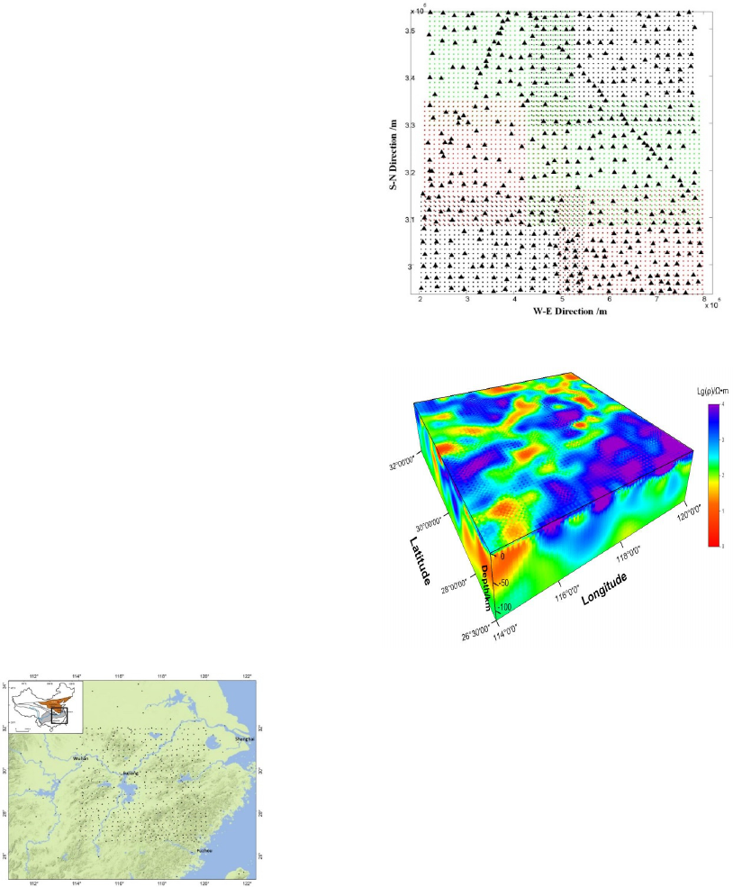
of each sub inversion result. Figure 1 shows the
actual MT stations’ distribution in the Southern
China. Figure 2 shows the six sub blocks. 3D
inversion is carried out according to the following
steps and finally an accurate 3D electrical structure
model is achieved. 21 frequency data are uniformly
selected from the logarithmic range of 320Hz-
5000S. In the horizontal direction, the center of the
model within MT stations is divided by 10km
uniform grid. In the vertical direction, to start with
50m thickness as the first layer, and then step down
by 1.1 times gradually decline until reaching enough
depth. 100 Ω•m homogeneous half space are
selected as the initial model, and the mode of non
diagonal impedance tensor (Z
XY
,Z
YX
) is used for 3D
inversion calculation. After 3D inversion calculation
of each sub block is finished in turn, we can get the
fusion electrical structure model of the whole work
area using each sub block 3D result (Figure 3). The
RMS error of the model is 2.75, the data fitting is
relatively well, and the inversion results are credible.
Figure 1: Map of study area and location of MT stations
(The area of the work area is about 350 thousand square
kilometres. A total of 525 wide-band magnetotelluric
sounding stations were acquired.)
Figure 2: Actual MT stations and six sub blocks partition.
Figure 3: 3D lithosphere electrical structure model of
eastern Jiangnan orogen.
4 3D ELECTRICAL
CHARACTERISTICS OF
EASTERN JIANGNAN
OROGEN
4.1 Plane Electrical Characteristics and
Structural Units Division
The value of plane vertical conductance is calculated
by layer thickness and the corresponding resistance.
It is usually expressed in symbol S, S=H/ρ,
representing local rock conduction ability of a
certain thickness. The Southern China has
experienced a complex geological evolution history
that its geological structure is complicated. For the
theoretical of different geophysical exploration
methods are different, the methods of dividing
Lithospheric Electrical Characteristics of Eastern Jiangnan Orogen, South China
417
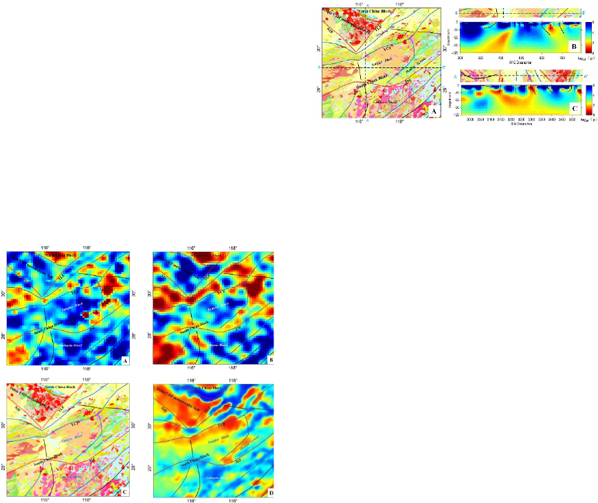
structural units may be different as well. Figure 4a
displays plane vertical conductance within 50 km
thickness of South China which is calculated using
3D electrical structure model. In accordance with
electrical characteristic differences, and additionally
combining with plane resistance characteristics at
the depth of 10 km (Figure4b), regional geology on
surface (Figure 4c) and satellite magnetic anomaly
(Figure 4d), the working area is divided into 4 first-
order tectonic units and 16 secondary tectonic units.
The 4 first-order tectonic units include low
resistance North China zone, high resistance Dabie
orogenic belt zone, low resistance and high
resistivity interval Yangtze zone and high resistance
Cathaysia massif zone. As can be seen from Figure
4, the electrical characteristics of each structural unit
have a good spatial correspondence with the regional
geology and the satellite magnetic anomaly.
Figure 4: Structural units division of eastern Jiangnan
orogen. (a) plane vertical conductance within 50 km
depth; (b) plane resistance characteristics within 10 km
depth; (c) regional geological map on earth surface; (d)
satellite magnetic anomaly. TLF:Tancheng-Lujiang fault,
XGF:Xiangfan-Guangji fault, YCF:Yangxing-Changzhou
fault, JSF:Jiangshan-Shaoxing fault.
4.2 Vertical Electrical Characteristics
and the Relationship between
Different Structural Units
As can be seen from the plane vertical conductance
map (Figure 4a), the North China block is of low
resistance characteristic, while the Dabie orogenic
belt and the Cathaysia massif are characterized by
high resistance. The Yangtze block is featured by
middle high resistance and low resistance around.
Different structural units in both horizontal and
vertical directions clearly show different electrical
characteristics.
Figure 5: Vertical electrical characteristics of two profiles.
(a) the position of two profiles AA’ and BB’. (b) electrical
characteristics of the West-East line BB’. (c) electrical
characteristics of the South-North line AA’.
In order to study the contact relationship between
various structural units, two electrical profiles are
selected in the work area (Figure 5). From profile C
(A-A') in Figure 5, the high resistance with a U-
shaped structure in the deep is performed in the
Dabie mountain, the deepest place can reach about
80 km depth, indicating obvious high resistance
"root" characteristic. There is a high conductivity
layer in the depth of about 30 km through deep high
resistance zone under the Dabie mountain. The
exploration results of the low resistivity layer are in
agreement with previous results. The fractures
located on both sides of Dabie mountain are steep,
and enclosed to the high conductivity layer in the
deeper. The Yangtze block is characterized by high
resistance in the middle and low resistivity around,
and there is a large low resistance anomaly under the
middle high impedance body. Low resistance belt
along the Yangtze River which is located in the
north of Yangtze massif shows apparent high
conductivity characteristic. The low resistivity zone
is linked to low resistance anomalous in deep
mantle. The Jiangshao fault located in the southern
margin of the Yangtze block is characterized by a
narrow range of low resistance zones under which
there is an local upward protruding structure. It can
be seen from the profile (B-B') in Figure 5 that the
middle part of the Yangtze block and Cathaysia
massif are characterized by a wide range of high
resistance. It is probably the base structure formed in
the Neoproterozoic Era, and its anomaly range and
depth of high resistivity are much larger than those
of the Dabie Mountains. HuaiYu terrane located in
the east of Yangtze block is of high conductivity
characteristic. The shallow low-resistance
anomalous connected with low resistance fluid in
deep mantle through a narrow passage. Tendency of
low resistance anomalies overall represents to
southeast. The above two profiles clearly
IWEG 2018 - International Workshop on Environment and Geoscience
418
demonstrate the electrical characteristics of each
structural unit and the contact relationship between
each other. The 3D electrical structure model is of
great value to study the formation and evolution of
the Southern China continent and the ore controlling
factors of deep deposit.
5 GEOLOGICAL SIGNIFICANCE
REVEALED BY THE 3D
ELECTRICAL MODEL
Generally the 3D electrical structure model contains
abundant underground information. The
characteristics of ‘U’ shape high resistance root in
the deep part of Dabie Mountains indicates that the
northside of North China block and the southside of
Yangtze block collided and subducted beneath the
high resistance bodies of the Dabie Mountains,
which made the Dabie mountains shows an obvious
compression uplift structure pattern. During the
Permian - Triassic period, the tectonic environment
in the Southern China area expanded, the low
resistivity layer was formed at the 30km depth
below the Dabie Mountain. Low resistance belt
along the Yangtze River located in front-end Dabie
orogenic belt shows significant high conductivity
characteristics. The low resistance abnormal body is
related with deep low resistance anomalous in upper
mantle, which could form the migration channel for
deep soft fluid. The low resistance channel may have
closed relationship with the distribution of abundant
of metal mineral resources above. Huaiyu terrane
located in the east of Yangtze block is of high
conductivity characteristic, suggesting obvious
collage of tectonic patterns, with which the two low
resistance layers in crust exist. The double low
resistivity layer may indicate the existence of a
double crustal structure. Double crust structure has
formed its unique form of mineral resources system.
Jiangshao fault shows an evident low resistivity
characteristic, and the low resistivity zone tends to
the Southeast. Its formation may be related to the
cracking events during Early Neoproterozoic-
Paleozoic era. At that same time, a lot of low
resistance layers were widely developed in crust
during the cracking period.
6 CONCLUSIONS
This paper introduces the process of how to
construct 3D electrical structure model of eastern
Jiangnan orogen by WSINV3DMT inversion
program which based on REBOCC 3D inversion
algorithm. Based on the 3D electrical structure
model and other related geophysical data, the 3D
electrical structure characteristics and geological
significance of Jiangnan orogenic belt are analyzed
and the following conclusions are obtained:
Using regional magnetotelluric data, the 3D
electrical structure model of eastern Jiangnan orogen
is established for the first time. Combined with
regional geology, regional gravity and magnetic
data, the eastern JiangNan orogen can be divided
into 4 first-order structural units and 16 secondary
structural units.
The characteristic of ‘U’ shape high resistance
root in the deep part of Dabie Mountains indicates
the North China block and Yangtze block collided
and subducted beneath the Dabie Mountains on the
north and south sides individually, suggesting strong
compression uplift tectonic settings.
Huaiyu terrane located in the eastern of Yangtze
block shows low resistivity, implying apparent
obduction tectonic environment. There are obvious
assaulting low resistance anomalous in the lower
section along the collage tectonic belt, and these low
resistance anomalous could be related to the
distribution and formation of a large number of
metal minerals above.
Jiangshao fault shows an obvious low
resistivitythat the low resistivity zone tends to the
Southeast, which means Cathaysia massif collided
over the Yangtze block.
ACKNOWLEDGMENTS
Thanks to all the staff involved in the field data
acquisition of this project, they have worked hard to
obtain valuable data. All the observation data in this
article are done with the support of multiple projects.
This study is supported by the National Key R&D
Program of China (No.2016YFC0600201), the
National Natural Science Fund (No.41574068),
Geological Investigation Project
(No.121201108000160913, No.12120114005801)
and CAGS basic research project (No.AS2016J12,
No.JYYWF20180902).
REFERENCES
Cai J T and Chen X B 2010 Refined techniques for data
processing and two-dimensional inversion in
magnetotelluric Ⅱ : Which data polarization mode
Lithospheric Electrical Characteristics of Eastern Jiangnan Orogen, South China
419
should be used in 2D inversion Chinese J. Geophys. (in
Chinese) 53(011) 2703-2714
Chen L S and Liu G D 1984 Magnetotelluric sounding
method [M] Geological publishing house
Chen X B, Ln Q T, Zhang K 2011 Review of
magnetotelluric data inversion methods Progress in
Geophys (in Chinese) 26(5) 1607-1619
Dong H, Wei W B, Ye G F, et al. 2012 Study of two
dimensional magnetotelluric inversion of complex
three dimensional structures Chinese J. Geophys (in
Chinese) 55(12) 4003-4014
Dong S W and Ma licheng 2011 On Dynamics of the
Metallogenic Belt of Middle-LowerReaches of
Yangtze River, Eastern China [J] Journal of geology
12 612-625
Newman GA and Alumbaugh DL 2000 Three-dimensional
magnetotelluric inversion using non-linear conjugate
gradients GEOPHYSICAL JOURNAL
INTERNATIONAL 140 (2) 410-424
Patro PK and Egbert GD 2008 Regional conductivity
structure of Cascadia: Preliminary results from 3D
inversion of USArray transportable array
magnetotelluric data GEOPHYSICAL RESEARCH
LETTERS 35(20) Art. No. L20311
QIU Gen-gen,FANG Hui,ZHONG Qing, et al. 2014 Study
for MT 3D Inversion in the Middle and Lower Reaches
of the Yangtze River Important Mineralization Zones
and Its Adjacent Area[J] Progress in Geophysics(in
Chinese) 29(6) 2730-2737
Rodi W and Mackie R L 2001 Nonlinear conjugate
gradients algorithm for 2-D magnetotelluric inversion
GEOPHYSICS 66(1) 174-187
Rodi W L 1976 A technique for improve the accuracy of
finite element solution for magnetotelluric data [ J ]
Geophy J R Astr Soc 44 483-506
Siripunvaraporn W and Egbert G 2000 An efficient data-
subspace inversion method for 2-D magnetotelluric
data Geophysics 65(3) 791-803
Siripunvaraporn W and Egbert G 2009 WSINV3DMT:
Vertical magnetic field transfer function inversion and
parallel implementation Physics of the Earth and
Planetary Interiors 173(3) 317-329
Siripunvaraporn W, Egbert G, Lenbury Y, et al. 2005
Three-dimensional magnetotelluric inversion: data-
space method Physics of the Earth and Planetary
Interiors 150(1) 3-14
Siripunvaraporn W, Uyeshima M and Egbert G 2004
Three-dimensional inversion for Network-
Magnetotelluric data
Earth Planets and Space 56(9)
893-902
TANG Jingtian, ZHOU Cong, REN Zhengyong, et al.
2014 Three Dimensional Magnetotelluric Inversion
and Structural Framework of Tongling Ore District,
Anhui[J] ACTA GEOLOGICA SINACA 04 598-611
YANG Wencai, XU Yixian, ZHANG Luolei, et al. 2015
Magnetotellruic investigation and 3d lithospheric
structures in the Tarim Terrane[J] ACTA GEOLOGICA
SINACA 07 1151-1161
YANG Wencai, ZHANG Luolei, XU Yixian, et al. 2015
Three dimensional electrical resistivity structures of the
Tarim Basin[J] ACTA GEOLOGICA SINACA 12 2203-
2212
IWEG 2018 - International Workshop on Environment and Geoscience
420
