
Ontological Representation of Constraints for Geographical Reasoning
Gianluca Torta
1
, Liliana Ardissono
1
, Marco Corona
1
, Luigi La Riccia
2
and Angioletta Voghera
2
1
Dipartimento di Informatica, Universit
`
a di Torino, Torino, Italy
2
Dipartimento Interateneo di Scienze, Progetto e Politiche del Territorio, Torino, Italy
Keywords:
Geographic Knowledge, Geographical Constraints, GeoSPARQL, Ecological Networks, Urban Planning.
Abstract:
We describe a framework that supports multiple types of constraint-based reasoning tasks on a geographic
domain, by exploiting a semantic representation of the domain itself and of its constraints. Our approach is
based on an abstract graph representation of a geographical area and of its relevant properties, for performing
the reasoning tasks.
As a test-bed, we consider the domain of Ecological Networks (ENs), which describe the structure of existing
real ecosystems and help planning their expansion, conservation and improvement by introducing constraints
on land use. While some previous work has been done about supporting the verification of compliance of fully
specified ENs, we aim at taking a significant step further, by addressing the automatic suggestion of suitable
aggregations of land patches into elements of the EN. This automated generation of EN elements is relevant
to support the human planner in the design of public policies for land use because it leverages automated tools
to carry out a possibly lengthy and error-prone task.
1 INTRODUCTION
This paper describes a framework supporting
constraint-based reasoning tasks on a geographic
domain. We take the motivating example of Eco-
logical Networks (ENs) (Bennett and Mulongoy,
2006) as a starting point to define a more general
geographic reasoning model in which both the
domain and its constraints are uniformly represented
as OWL ontologies (W3C, 2017). In this way, we
can benefit from the expressiveness provided by
standard Semantic Web languages in the specification
of domain knowledge.
ENs have been introduced to describe the structure
of existing real ecosystems and help planning their
expansion, conservation and improvement by impo-
sing constraints on land use. However, up to now,
the design of the ENs structure, and the definition of
public policies proposing land use transformations to
comply with the EN constraints, have been carried out
manually, in a lengthy and possibly error-prone type
of activity. This is due to the informal specification
of ENs, which consists of a rather large number of
guidelines expressed in Natural Language.
In this paper, we propose to represent both the EN
domain and its constraints in a semantic knowledge
representation language, with the aim of supporting a
number of automated reasoning tasks concerning the
design of the structure of the EN, as well as urban
and regional plans and projects for transforming a ge-
ographic area so that it (better) complies with the EN
specification. A desired side effect of those activities
is to construct the social awareness on bindings and
opportunities related to ENs for quality of life.
Specifically, we aim at developing a framework
for the automated suggestion of suitable aggregations
of land patches of a geographic area into elements of
an EN. The main contributions of this paper are:
• An ontological representation of ENs and of the
related constraints on land use which supports
knowledge sharing and semantic reasoning. Our
work fully adheres to the GeoSpatial Semantic
Web paradigm (Janowicz et al., 2012a), which
promotes standard knowledge representation lan-
guages to maximize data and application intero-
perability.
• A model for the automated generation of a graph-
based, abstract representation of a geographical
area, which specifies the ecological and land use
characteristics of land patches, and their adja-
cency relations. Specifically, the nodes of the
graph represent homogeneous pieces of land, each
one associated with a given set of defined proper-
ties; e.g., naturalness, or irreversibility of the land
use. The arcs represent abstractions of the adja-
136
Torta, G., Ardissono, L., Corona, M., Riccia, L. and Voghera, A.
Ontological Representation of Constraints for Geographical Reasoning.
DOI: 10.5220/0006960901360147
In Proceedings of the 10th International Joint Conference on Knowledge Discovery, Knowledge Engineering and Knowledge Management (IC3K 2018) - Volume 2: KEOD, pages 136-147
ISBN: 978-989-758-330-8
Copyright © 2018 by SCITEPRESS – Science and Technology Publications, Lda. All rights reserved

cency relations between nodes.
• An extensible framework that exploits the graph-
based model for performing reasoning tasks on
the EN domain, guided by the knowledge enco-
ded in both the domain and constraints ontologies.
As a proof-of-concept, the current implementa-
tion of our framework is equipped with two rea-
soners optimized to solve specific types of tasks:
i.e., finding paths that connect certain areas, and
clustering areas characterized by the same given
properties.
Even though the ultimate goal of our work is to pro-
vide ontologies and specialized reasoners that allow a
fully-automated, mixed-initiative management of re-
asoning tasks on geographical areas, in this paper, we
focus on tasks relevant to the ENs domain.
The remainder of this paper is organized as fol-
lows: Section 2 provides some background on seman-
tic knowledge representation and ENs. Sections 3 and
4 present our knowledge representation and reasoning
model. Section 5 describes the framework implemen-
tation and Section 6 positions it in the related litera-
ture. Sections 7 and 8 present our future work and
conclude the paper, respectively.
2 BACKGROUND
2.1 Semantic Representation of
Geographic Information
The GeoSpatial Semantic Web vision, presented in
(Janowicz et al., 2012a), advocates for represen-
ting geographical information by means of ontologies
suitable for explicitly describing concepts and relati-
ons among concepts. This is important to support a
conceptual notion of data interoperability, which goes
beyond the adoption of a common representation for-
mat, and is aimed at enabling correct data interpreta-
tion and inferences in geographical reasoning.
Even before the birth of this vision, several geo-
graphical ontologies were developed to support infor-
mation sharing and retrieval. For instance, Fonseca et
al. proposed an ontology to classify geographic ele-
ments with respect to geometric characteristics and at-
tribute values; i.e., semantic features (Fonseca et al.,
2002a). Moreover, they discussed semantic granula-
rity, i.e., the level of detail at which geographic ob-
jects are described, focusing on interoperability is-
sues; see (Fonseca et al., 2002b).
Some general ontologies have been published to
share toponyms and generic geographic concepts;
e.g., the GeoNames Mappings ontology (GeoNa-
mes.org, 2018) based on the GeoNames database
(http://www.geonames.org/). Researchers have also
focused on spatial granularity to describe toponyms
at different levels of detail; e.g., see (Palacio et al.,
2015). Other ontologies have been developed to pro-
vide a semantics of Volunteer Geographical Informa-
tion. For instance, LinkedGeoData links crowsour-
ced OpenStreetMap (OSM) information to GeoNa-
mes and others ontologies (Janowicz et al., 2012b).
Moreover, focusing on Open Data and crowdsourced
data, Baglatzi et al. (Baglatzi et al., 2012) bridged the
gap between ontological and crowdsourcing practices
via ontological alignment. Furthermore, OSMonto
(Codescu et al., 2011) has been defined to structure
the implicit ontology of OpenStreetMap (OpenStreet-
Map Contributors, 2017) tags and to format it into an
RDF (W3C, 2017b) scheme.
Besides the work supporting geographic informa-
tion sharing and retrieval, more specific ontologies
have been defined to describe fine-grained aspects
of geographical objects. Of primary importance for
the present work is the GeoSPARQL ontology (OGC,
2012), which describes geographical objects suppor-
ting the specification of their geometry, as well as to-
pologic relations among different objects.
Other ontologies relevant to the present work are
the ones that model the types of land use/cover, e.g.,
LBCS-OWL2 (Montenegro et al., 2011), HarmonISA
(Hall and Mandl, 2006). As we shall see, we have
currently adopted a taxonomy based on the Land Co-
ver Piemonte (LCP) cartography (Provincia di Torino,
2014), mainly because the experimental data availa-
ble to us was tagged according to it, see project (Citt
`
a
Metropolitana di Torino, 2014).
2.2 Ecological Networks
Ecological Networks (ENs) have been proposed to
preserve biodiversity by reducing the process of na-
ture fragmentation caused by the development of new
urbanizations, infrastructural networks and intensive
agriculture (Jongman, 1995). Recently, there has been
an exponential growth of urban land use towards more
natural spaces: external urban areas (uncultivated or
abandoned cultivated land, burnt areas, degraded fo-
rests) have often been confined from urban and regio-
nal planning to an “inessential” position and someti-
mes simply considered as “waiting areas for a new ur-
banization”. As reported in (Bennett and Mulongoy,
2006), “ecological networks share two generic goals,
namely:
1. Maintaining the functioning of ecosystems as a
means of facilitating the conservation of species
Ontological Representation of Constraints for Geographical Reasoning
137

Figure 1: Ecological Network representation, from (Bennett
and Mulongoy, 2006).
and habitats.
2. Promoting the sustainable use of natural resources
in order to reduce the impacts of new urbanizati-
ons on biodiversity and/or to increase the biodi-
versity value of managed landscapes”.
Despite the Protected Areas and Natura 2000 si-
tes are now considered the backbone of European po-
licy for biodiversity, the increasing expansion of ur-
banizations and infrastructural networks is challen-
ging the conservation of natural habitats for the pre-
servation of animal species and plant varieties. The
policies for the improvement of EN are necessary to
overcome the fragmentation of the habitats and natu-
ral areas, which is the main cause of biodiversity loss
in Europe. The consequences of these processes can
be summarized in the following phenomena (Benedict
and McMahon, 2002):
1. The substantial loss of natural areas due to urban
development.
2. The fragmentation of natural areas into smaller,
disconnected patches.
3. The degradation of wetlands, which have an im-
portant ecological function for the control of wa-
ter flows, the ability to block sediments, for the
support of plant and animal species, etc. (step-
ping stone function) and for the ability to provide
nutrients for the ecosystems.
4. The inability of ecosystems to respond to changes
and find a new ecological balance: that is to say a
significantly reduced resilience.
5. The loss of ecosystem services, such as the control
of water and the filter functions for pollutants.
6. The increased economic costs for public services,
due to the response to natural disasters deriving
from human footprint.
An Ecological Network can be defined as an inter-
connected system consisting of territorial areas that
include natural and semi-natural habitats. The typical
representation of an EN is a network of core areas in-
terconnected by corridors; see Figure 1. According to
(Bennett and Mulongoy, 2006):
• Core Areas are the areas “where the conservation
of biodiversity takes primary importance, even if
the area is not legally protected”.
• Buffer Zones are the areas which “protect the net-
work from potentially damaging external influen-
ces and which are essentially transitional areas
characterized by compatible land uses”. They are
important to safeguard and increase the stability
of the core areas.
• Corridors “serve to maintain vital ecological or
environmental connections by maintaining physi-
cal (though not necessarily linear) linkages bet-
ween the core areas”.
• Sustainable-use areas are zones “where opportu-
nities are exploited within the landscape mozaic
for the sustainable use of natural resources toget-
her with maintenance of most ecosystem servi-
ces”.
So far, the work about ENs has mostly focused on the
following perspectives:
1. Ecological network analysis has dealt with stu-
dying and simulating in a mathematical way the
interaction between organisms within the ecosy-
stem, the dynamics of the relations among spe-
cies, the existence of dynamical bottlenecks in
the functioning of the ecosystems, etc.; see, e.g.,
(Fath et al., 2007; Ulanowicz, 2004; Fath et al.,
2007; Lurgi and Robertson, 2011; Gobluski et al.,
2016; Pilosof et al., 2017). This research line has
a different goal than ours. In fact, it aims at pre-
dicting the evolution of an EN starting from an
initial status, but it does not deal with represen-
ting and reasoning with the land use constraints.
2. Several ENs have been implemented at different
scales (from European down to municipality), re-
sulting in the production of different guidelines
on land use, and planning documents, expressed
in Natural Language; e.g., (Council of Europe,
2000; Bennett and Wit, 2001; Bennett and Mu-
longoy, 2006). However, their linguistic specifi-
KEOD 2018 - 10th International Conference on Knowledge Engineering and Ontology Development
138

Figure 2: A portion of the EN Ontology.
cation makes it hard to present EN elements in ge-
ographical maps, which have to be manually cre-
ated. Moreover, it challenges an automated verifi-
cation of EN constraints.
To the best of our knowledge, the only work pursuing
the automation of a task needed for EN project plan-
ning is the one described in (Torta et al., 2017; Torta
et al., 2018), which focuses on EN validation. As dis-
cussed later on, we extend that work by adopting a
unified semantic approach for a holistic representa-
tion of knowledge about ENs and about their con-
straints. Moreover, we adopt a more general approach
to the supported reasoning tasks.
3 KNOWLEDGE
REPRESENTATION
3.1 Ecological Networks Representation
Our EN Ontology describes the main concepts and
relations of Ecological Networks. We defined it
starting from the specifications produced in project
“Experimental activity of participatory elaboration of
ecological network” (Citt
`
a Metropolitana di Torino,
2014), conducted by the Metropolitan City of Turin
(Italy)
1
in collaboration with Polytechnic of Turin
2
and ENEA
3
. Specifically, in the present work we ex-
tend and refine the ontology proposed in (Torta et al.,
2017; Torta et al., 2018). The above mentioned pro-
ject aimed at defining a proposal for the Ecological
Network implementation at the local level in two pi-
lot municipalities near Turin. The proposed appro-
1
www.cittametropolitana.torino.it/
2
www.polito.it
3
www.enea.it
ach was aimed at guiding local Public Administra-
tions with measures to limit anthropogenic land use
and, where possible, orient and qualify the conserva-
tion of ecosystem services.
Figure 2 shows the main classes of the EN On-
tology, which is developed in OWL (W3C, 2017),
and is augmented by the GeoSPARQL ontology
(OGC, 2012). The graphic notation is borrowed from
(Van Hage et al., 2011); in particular, arrows with
open arrow heads symbolize subclass relationships
between the classes, while regular arrows connect
domains and ranges of properties
4
. The top class of
the EN Ontology is the Feature, a class defined in the
GeoSPARQL ontology and colored in dark gray for
easy recognition. A Feature has a Geometry on the
2D plane, and can thus be used to represent points, li-
nes, and areas on a geographic map. GeoSPARQL de-
fines a number of topological geometric relations be-
tween Features that correspond to fundamental relati-
ons (such as intersects, equals, contains, etc.) known
in the literature as Simple Features (Open Geospatial
Consortium et al., 2011).
In order to define ENs, we specify the Feature
class into the four hierarchies of classes representing
the core of the domain. The roots of these hierarchies
are colored in gray.
• ENElement represents an element of the EN. This
is either a Core Area (CoreArea), a Sustainable-
use area (SustArea), or a Priority Expansion Ele-
ment, which is further specialized to a Corridor
(Corridor) or Buffer Zone (Buffer).
• Intervention represents an intervention for buil-
ding, improving or conserving the EN.
• Operation represents a specific operation of elimi-
nation (Elimination), construction (NewPlanting),
4
The diagrams were created with the Dia tool.
Ontological Representation of Constraints for Geographical Reasoning
139

Figure 3: Portion of the LandUseElement hierarchy.
or maintenance (Maintenance) that is part of an
intervention.
• Patch represents a small area of the map characte-
rized by a specific land use; see below.
It is worth noting that a Patch P typically belongsTo
an EcologicalNetworkElement E, and E is madeOf
patches including P.
Figure 3 shows the LandUseElement hierarchy.
Each class of the hierarchy is a singleton, containing
exactly one representative object characterized by:
• A specific type of land use defined in the Land
Cover Piemonte (LCP) cartography (Provincia di
Torino, 2014): e.g., wetland (WetLand), wooden
land (WoodenLand), and similar. The LCP defines
97 different types of land use at the most detailed
level (LCPlvl4) of a hierarchy which includes 45
classes at level 3 (LCPlvl3), 15 classes at level 2
(LCPlvl2), and 5 general classes at the most gene-
ral level LCPlvl1.
• Five evaluation criteria (OWL properties of Lan-
dUseElement, not shown in Figure 3) (Voghera
and La Riccia, 2019):
– naturalness (how close is the element to a natu-
ral environment);
– relevance (how relevant it is for the conserva-
tion of the habitat);
– fragility (how fragile the element is with respect
to the anthropogenic pressure);
– extroversion (how much pressure it can exert on
the neighboring patches);
– irreversibility (how difficult it would be to
change the use of the element).
The value for each criterion ranges from 1 to 5,
and 1 represents the maximum value.
Each Patch of land is describedBy a LandUseEle-
ment; i.e., it is associated with a specific land use.
For our current purposes, the description of land pat-
ches with the attributes we have just described is suf-
ficient. In future work we may consider associating
more refined information with patches, exploiting ex-
isting ontologies for modeling additional environment
and ecologic concepts, e.g., ENVO (Buttigieg et al.,
2016) and EcoCore (Buttigieg, 2018).
The Intervention and Operation hierarchies are in-
tended for supporting the planning of improvements
and expansions of the EN. At the current stage of our
work we have modeled them with a few, simple con-
cepts that are sufficient for our purposes. As we ex-
tend our work towards a full-fledged project planning
support system (see section 7), we shall consider ex-
isting works such as (Lazoglou and Angelides, 2016;
SDS Consortium, 2017), which aim at a detailed mo-
deling of the concepts involved in spatial planning and
spatial Decision Support Systems.
Compared to the ontology defined in (Torta et al.,
2017; Torta et al., 2018), the described portion of the
EN Ontology refines the class ENElement in the types
of EN elements defined in (Bennett and Mulongoy,
2006). Moreover, it establishes a specific relation be-
tween EN Elements (e.g., Corridor) and the Patches
they are made of. Furthermore, it specifies the land
use characteristics of each patch by associating it with
a LandUseElement.
3.2 Constraints Representation
Constraints in a geographical domain such as ENs
must be able to express restrictions about the objects
of the world modeled by the domain ontology, mix-
ing logic, geometric, and numeric requirements; e.g.,
see (Louwsma et al., 2006). For example, they can
refer to the allowed values of categorical attributes of
areas, to the sum of the sizes of a set of areas, to the
topological relations between pairs of areas, and so
forth.
We have modeled constraints with a Constraint
Ontology, whose classes refer to classes and proper-
ties of the EN Ontology
5
. We have defined several
kinds of constraints, inspired by the kinds of con-
straints that may appear in a configuration knowledge
base (Soininen et al., 1998; Stumptner et al., 1998;
Felfernig et al., 2002). Figure 4 shows a portion of our
Constraints Ontology, which is structured as a hierar-
chy rooted by class Constraint (in dark gray):
5
In OWL, referring to classes and properties as values of
other properties is a delicate point; see (W3C, 2017a). We
currently avoid these difficulties by exploiting such referen-
ces only in SPARQL queries.
KEOD 2018 - 10th International Conference on Knowledge Engineering and Ontology Development
140
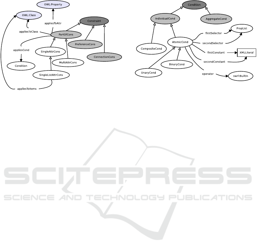
Figure 4: Diagrammatic representation of a portion of the
constraints hierarchy.
• PartOfConstraint (PartOfCons) refers to a con-
straint that applies to one or more parts of a given
object. Note that a part may be shared by more
than one object; i.e., its semantics is similar to the
aggregation of UML (Object Management Group,
2008).
– SingleAttributeConstraint (SingleAttrCons) in-
volves a single (part-of) attribute of the object.
– MultiAttributeConstraint (MultiAttrCons) in-
volves more than one (part-of) attribute of the
object.
• ConnectionConstraint (ConnectionCons) refers to
a constraint that applies to a relationship between
more than one object.
• PreferenceConstraint (PreferenceCons) repre-
sents soft constraints, that augment regular
constraints with functions to be optimized.
Let us focus on the SingleAttributeConstraints
(SACs). First of all, they refer to a single class (ap-
pliesToClass) and attribute of such class (appliesToAt-
tribute). Note that an attribute of class C is an OWL
property with class C as a possible domain. A spe-
cial kind of SACs applies to attributes that are orde-
red lists of objects/values. In that case, a subset of the
list elements to which the SAC applies can be identi-
fied, through the appliesToItems property. Currently,
this property only allows the specification of the par-
ticular class of the items that should be affected by
the constraint. In a future version, we may allow fil-
tering conditions that select such elements based on
their characteristics.
A SAC specifies a condition through the applies-
Condition property; see Figure 5. The main dis-
tinction is between AggregateConditions (Aggrega-
teCond, in gray), that specify restrictions on some
aggregate quantity computed from the elements of
Figure 5: A portion of the condition hierarchy.
a list attribute, and IndividualConditions (Individual-
Cond) that apply to each value of a list attribute, or
to the unique value of a scalar attribute. Individual
conditions are built by composing AtomicConditions
(AtomicCond) into CompositeConditions (Composi-
teCond) with the usual logic connectives and, or, not.
A BinaryCondition has two operands and an ope-
rator (UnaryConditions have an empty secondOpe-
rand). The operands are either constant values (i.e.,
XMLLiterals) or selectors. A selector is modeled as
a list of properties: the list specifies a path from the
element E that is being checked to a value that is re-
achable from E through the chain of properties in the
list.
Note that the the main goal of the representation
is the specification of various meta data about con-
straints; e.g., see the distinction between part-of, con-
nection, and preference constraints. The ontology can
be extended and refined as needed for expressing ad-
ditional meta data. This is a key element for the deve-
lopment of reasoners that must automatically retrieve
the suitable constraints to perform constraint solving,
given the characteristics of the input problem.
Example 1. Let us consider the LandscapeCorridor
class in the EN ontology of Figure 2 (see also Fi-
gure 1). A specification taken from the guidelines for
the Local EN implementation devised in project (Citt
`
a
Metropolitana di Torino, 2014) states that:
Corridors avoid areas with maximum irrever-
sibility and areas with maximum extroversion.
A landscape corridor is therefore made of patches
that must exhibit the specified characteristics. We can
associate a suitable constraint with class Landscape-
Corridor. The constraint has the following traits:
• it is a SingleListAttributeConstraint, because the
patchList property has a list value;
• it specifies an IndividualCondition that consists of
the conjunction of two BinaryConditions;
Ontological Representation of Constraints for Geographical Reasoning
141

• the first BinaryCondition requires a non-
maximum irreversibility; it specifies:
– the firstOperand as a PropertyList containing
the properties describedBy (from Patch to Lan-
dUseElement) and irreversibility (from LandU-
seElement to the value of the irreversibility cri-
terion);
– the operator as swrlb:greaterThan;
– the secondOperand as the constant value 1.
• the second BinaryCondition is similar to the first
one, but it requires non-maximum extroversion.
3.3 Representation of Individual
Information Items
The instances of the domain classes defined in the EN
Ontology, such as the Patches of land that form the
map of a geographic area of interest, are stored in
RDF format (W3C, 2017b) in a triple store that re-
presents the knowledge base used by the system. The
translation from input data-sets (typically available as
ESRI shapefiles) to RDF triples is carried out by our
data import functions; see Section 5.
Analogously, the triple store contains the instan-
ces of the constraints classes representing actual con-
straints that apply in the domain, such as the sample
constraint described in Example 1.
4 GEOGRAPHIC REASONING
4.1 The Adjacency Graph Model
We aim to deal with geographic domains, as the Eco-
logical Networks that motivated our work. Thus, it
has been natural to base our reasoning system on a
data model structured as a graph G = (N, E) where:
• the nodes N correspond to areas of a map;
• the arcs E connect nodes whose associated areas
are adjacent in the map.
Figure 6 shows a map and the corresponding ad-
jaciency graph. In the figure, the graph nodes corre-
sponding to the areas of the map. For example, node
1 corresponds to an area that is adjacent to the areas
corresponding to nodes 2, 3, 5, and 6. Note that, mo-
ving from the map to the graph model, some noise
has been abstracted away; e.g., nodes 5 and 8 are con-
nected although their areas do not actually touch each
other. This abstraction is needed to deal with real-
world, imperfect GIS data, and is a basic task that can
be performed by our system. In particular, when a
1
2
3
5
6
4
7
8
Figure 6: A map and its corresponding adjacency graph.
new area A is inserted into the knowledge base of the
system, standard geometric algorithms can be used to:
(i) compute an expansion A
0
of A consisting of A with
a border of a given thickness, and
(ii) determine the adjacent areas as the ones that in-
tersect with such expanded area A
0
.
It is worth pointing out that, while GeoSPARQL
provides a set of functions to compute the Simple Fe-
atures topological relations it defines, those functions
require that the involved geometries exactly satisfy
the relation, e.g., an area touches another area iff they
share some common points on their borders, but no
internal points. This function is clearly too restrictive
to determine the adjacency of two areas in a meaning-
ful way for our purposes.
As a matter of fact, the graph model is able to ea-
sily accomodate more information than the associa-
tion between nodes and areas:
• Each node n ∈ N can have attributes representing
meta-information about the area A(n) associated
with n. In the EN domain, this may include:
– the values of the evaluation criteria and the LCP
levels of the LandUseElement describing A(n);
– information such as the area size and perimeter
of A(n);
– the identity of the EN Element (e.g., CoreArea)
to which A(n) belongs.
KEOD 2018 - 10th International Conference on Knowledge Engineering and Ontology Development
142

• Each arc e = (n
i
, n
j
) ∈ E can have attributes that
represent meta-information about the relationship
between A(n
i
) and A(n
j
). For example:
– the length of the perimeter shared by the two
areas;
– a numeric “cost” of going from A(n
i
), to A(n
j
)
determined by the presence of a road/railway
between the two areas.
4.2 Reasoning Tasks
Our model supports reasoning tasks based on three
kinds of inputs:
• the OWL ontologies defining the domain con-
cepts, the constraints hierarchy, and their relati-
onships;
• the RDF data representing the instances of domain
classes of the EN Ontology, and the instances of
the constraints that apply to the specific domain;
• further requirements provided by the user to spe-
cify the desired reasoning task and its parameters.
Ideally, we would like that the system automatically
extracts all the information needed to perform a re-
quested task from the EN and Constraint Ontologies,
and from the constraint instances, and use it to drive a
generic reasoning engine to compute the answer from
the RDF domain instances. However, such a gene-
rality would be extremely hard, if not impossible to
achieve in practice. Instead, we equip the system with
a pre-defined (but extensible) set of reasoning capabi-
lities that can be reused for several specific tasks, and
fill the details of specific reasoning task requests by
exploiting all the input sources mentioned above.
Definition 1. A Reasoner R (Ω, ∆, ρ) is a function
that takes as inputs an OWL ontology Ω, a RDF graph
∆ and a request ρ and:
1. extracts from ∆ (driven by ontology Ω), a relevant
set of constraints C = C
B
∪ C
R
;
2. builds an adjacency graph model G using the con-
straints in C
B
;
3. performs a reasoning task on G using the con-
straints in C
R
;
4. returns a result α that answers the request ρ, given
Ω and ∆.
The extraction of constraints is done by issuing
SPARQL queries (W3C, 2017) on the RDF data ∆
built from the vocabulary of ontology Ω; see the next
section for an example. The retrieved constraints are
then returned as data structures that can be directly in-
terpreted by the reasoner in order to perform steps (2)
and (3) above.
Specific tasks are requested by executing Com-
mands that are translated to one or several invocations
of the reasoners with specific values of ρ.
In the next subsection, we shall briefly describe
two reasoners that we have implemented in order to
support the automated identification, starting from ge-
ographic data about an area, of core areas, and corri-
dors, according to the specifications given in the EN
Ontology.
4.3 Identifying Core Areas and
Corridors
Reasoner #1. The R
PAT H
reasoner is meant to receive
through the request θ two identifiers id
s
and id
e
of Pa-
tches or elements that aggregate Patches (i.e., EN ele-
ments), and the name of a property prop that is a list
of Patches or elements that aggregate Patches. It then
computes a path of adjacent elements from element
id
s
to id
e
taking into account the constraints associa-
ted with property prop.
This reasoner can be used to implement the com-
mand BUILD(LandscapeCorridor, id
s
, id
e
) which
assigns id
s
, id
e
to the from and to attributes of
LandscapeCorridor, and computes the value of the
patchList attribute by invoking R
PAT H
with θ =
(id
s
, id
e
, patchList).
1. First of all, the reasoner issues a number of
SPARQL queries to retrieve the SingleListAttribu-
teConstraint C associated with patchList (descri-
bed in Example 1).
2. Then, it builds an adjacency graph G in such a
way that the nodes of G are associated to patches
that satisfy C; i.e., they have non-maximum irre-
versibility and extroversion.
3. Finally, the reasoner applies a simple path-finding
algorithm based on the well-known A
∗
algorithm
(Dechter and Pearl, 1985) to identify a corridor
between the id
s
and id
e
elements, if any.
Reasoner #2. The R
CLUST
reasoner is meant to re-
ceive, through request θ, the identifier id of a Patch,
and the name of a property prop that is a one-to-many
relationship from a class and Patch. Given these in-
puts, the reasoner computes a clustering of patches
that satisfy prop, starting from id, by taking into ac-
count the constraints associated with property prop.
The reasoner can be used to implement the com-
mand BUILD(CoreArea, id), which computes the va-
lue of the madeOf attribute by invoking R
CLUST
with
θ = (id, madeOf ). Note that the madeOf attribute of
CoreArea is associated with a constraint that specifies
the characteristics of the patches P that can be inclu-
ded in a core area. These are the patches with high or
Ontological Representation of Constraints for Geographical Reasoning
143

medium ecological functionality, which is a function
of the naturality and relevance of the LandUseEle-
ment that describes patch P.
5 IMPLEMENTATION
We have implemented the model described in the pre-
vious sections as a Java library consisting of the fol-
lowing modules:
• data-import contains functions supporting the
import/export of shape files to/from a triple
store (e.g., Parliament (Battle and Kolas, 2012)),
the pre-processing and optimization of the geo-
metries associated with geo-SPARQL Features,
and the transfer of RDF triples between disk
and the in-memory model of the Jena library
(https://jena.apache.org/) used to query the triple
store;
• reasoning contains the functions for the creation
of the adjacency graph data model. Moreover, it
collects all the specific reasoners provided by the
system (currently, the R
PAT H
and R
CLUST
reaso-
ners described above);
• commands implements the parsing of commands
(currently, the two forms of the BUILD command
described above) and interfaces with the reaso-
ning and data-import functions to execute them;
• shared provides the definitions and implementati-
ons of elements relevant across the other modules,
such as the geometric feature and triple store ma-
nager, as well as utility functions used by the other
modules.
By exploiting the data-import module, we have po-
pulated the Parliament triple store with 395 patches
defined in the shape files of a portion of map situated
at the north of the Italian city of Turin. We have then
used the implementation of the R
CLUST
reasoner con-
tained in the reasoning module to generate the Core
Areas as clusters of patches with given characteris-
tics. The reasoner has generated 74 clusters. Finally,
we have used the implementation of the R
PAT H
re-
asoner to generate a number of landscape Corridors
between pairs of Core Areas specified by us.
6 RELATED WORK
To the best of our knowledge, the only work pur-
suing the automation of a task needed for EN project
planning is the one described in (Torta et al., 2017;
Torta et al., 2018). In that work, the authors defined
a machine readable specification of ENs to support
EN validation. They introduced an ad-hoc constraint
satisfaction language for the verification of EN con-
straints on a geographical area; e.g., to check whether
a certain area, identified as a Buffer zone in a pre-
defined EN, complies with the definition given in the
EN specifications, or not. While compliance verifica-
tion with respect to an pre-defined EN can be useful to
help the human planners in an EN planning task, our
aim is to take a step further, by addressing the automa-
tic suggestion of suitable aggregations of land patches
into elements of the EN. Moreover, we aim at automa-
tically suggesting modifications to existing elements
needed by the urban design projects, through suitable
interventions. Even though the current implementa-
tion of our model supports a limited kind of soluti-
ons to tasks only involving two types of elements of
ENs (e.g., the suggestion of modifications is out of the
scope of the present paper), the proposed approach is
designed to support full fledged implementations of
creation and modification tasks.
Another key aspect of our method is the represen-
tation of constraint types as classes of an OWL onto-
logy (the Constraints Ontology). In this way, we em-
ploy a single, well-known standard for the represen-
tation of semantic knowledge, and we avoid the intro-
duction of a new language, requiring ad-hoc tools for
managing constraint information. Even more impor-
tantly, an ontology of constraints supports a detailed
description of the different kinds of constraints (e.g.,
soft and hard, part-of and relational, aggregation and
individual) by qualifying their scope, purpose, relati-
onships, and so forth. This meta-information about
constraints enables the reasoners to retrieve the con-
straints that are relevant for the task at hand, and use
these constraints in the correct places and in the cor-
rect way. This is the reason why we did not adopt
any of the existing ways to represent constraints in
the Semantic Web, including rule languages such
as SWRL (Semantic Web Rule Language) (Horrocks
et al., 2004) and RuleML (Boley et al., 2001), or any
logical/functional languages such as CIF (Constraint
Interchange Format) (Gray et al., 2001). Those lan-
guages allow the definition of constraints as generic
rules or logic formulas, without characterizing their
properties as needed to automatically retrieve con-
straints and apply them for specific reasoning tasks.
Regarding the current implementation of the
R
PAT H
reasoner, it is worth noting that path finding
has been explored in recommender systems research
to suggest travel paths suiting individual preferences;
e.g., the shortest path between two endpoints, or a
path maximizing pleasure, calm, or other numerical
properties of an area (Quercia et al., 2014). Given
KEOD 2018 - 10th International Conference on Knowledge Engineering and Ontology Development
144

a graph representing the travel map of a geographi-
cal area, those works choose the path(s) composed of
road segments which, globally, maximize one or more
measures associated to the selected properties. These
approaches solve a specific task taking into account
a pre-defined set of constraints. Differently, we aim
at supporting multiple reasoning tasks and retrieving
relevant constraints from a semantic knowledge base
(e.g., an RDF store) by exploiting their description as
classes of an OWL ontology.
7 FUTURE WORK
The work presented in this paper builds a solid
ground, both from the modeling and reasoning points
of views, for supporting a user in the project planning
for a geographical domain such as the one of Ecolo-
gical Networks. However, there are several directions
in which our work may be extended to provide a full
fledged decision support system that human users can
effectively use in the definition of public policies for
land use. For instance, we plan to:
• extend the Constraint Ontology and refine it to
specify more types of constraints, especially soft
constraints for guiding the reasoners to compute
solutions that maximize some preference criteria;
and sophisticated geometric constraints about the
shapes, sizes, etc. of given areas;
• extend our reasoning framework with the ability
of exploiting soft constraints, and with additio-
nal reasoners (e.g., for proposing maintenance and
modification interventions on an EN with the goal
of expanding or improving it);
• create a GUI-based application to support the
mixed-initiative interaction between the human
user and the reasoning system to jointly perform
project planning tasks.
8 CONCLUSIONS
We described a semantic framework supporting va-
rious types of constraint-based reasoning tasks on a
geographic domain, from the basic validation of con-
ditions in a geographic area, to the suggestions for de-
fining and modifying EN elements. Different from ot-
her constraint-based geographic reasoners, our model
represents both the geographic domain and its con-
straints in OWL ontologies. This approach has se-
veral advantages: first of all, it does not introduce
any ad-hoc language for the management of con-
straints. Second, it fully exploits the knowledge re-
presentation and reasoning interoperability provided
by semantic languages for knowledge sharing and for
data/application interoperability. Third, it opens the
avenue to the classification of constraints for their au-
tomated management within reasoners able to adapt
to solve a range of reasoning problems.
As a test-bed for our framework, we considered
the domain of Ecological Networks. Whereas, at the
current stage, we implemented reasoning about ENs
as a stand-alone model, the main motivation and ap-
plication of our work lies in its possible integration
within Participatory Geographical Information Sys-
tems (PGIS, (Sun and Li, 2016)), in order to support
online interaction with stakeholders in inclusive pro-
cesses aimed at collecting feedback and project pro-
posals from stakeholders.
ACKNOWLEDGEMENTS
This work is partially funded by project MIMOSA
(MultIModal Ontology-driven query system for the
heterogeneous data of a SmArtcity, “Progetto di Ate-
neo Torino call2014 L2 157”, 2015-17), and by “Ri-
cerca Locale” of the University of Torino. We thank
Adriano Savoca for his precious contributions to the
initial steps of this work.
REFERENCES
Baglatzi, A., Kokla, M., and Kavouras, M. (2012). Se-
mantifying openstreetmap. In Proc. of Terra Cognita
Workshop on Foundations, Technologies and Applica-
tions of the Geospatial Web - CEUR Workshop Pro-
ceedings, Vol. 901, page paper 4. CEUR.
Battle, R. and Kolas, D. (2012). Enabling the geospatial
Semantic Web with Parliament and GeoSPARQL. Se-
mantic Web, 3(4):355–370.
Benedict, M. and McMahon, E. (2002). Green Infrastruc-
ture: smart conservation for the 21st century. Watch
Clearinghouse Monograph Series. Sprawl.
Bennett, G. and Mulongoy, K. (2006). Review of expe-
rience with ecological networks, corridors and buffer
zones. Technical Series, 23.
Bennett, G. and Wit, P. (2001). The development and appli-
cation of ecological networks: a review of proposals,
plans and programmes. AIDEnvironment.
Boley, H., Tabet, S., and Wagner, G. (2001). Design ratio-
nale of ruleml: A markup language for semantic web
rules. In Proceedings of the First Int. Conf. on Seman-
tic Web Working, pages 381–401. CEUR-WS. org.
Buttigieg, P. L. (2018). Ecology Core Ontology.
https://github.com/EcologicalSemantics/ecocore.
Accessed: 2018-07-28.
Ontological Representation of Constraints for Geographical Reasoning
145

Buttigieg, P. L., Pafilis, E., Lewis, S. E., Schildhauer, M. P.,
Walls, R. L., and Mungall, C. J. (2016). The envi-
ronment ontology in 2016: bridging domains with in-
creased scope, semantic density, and interoperation.
Journal of biomedical semantics, 7(1):57.
Citt
`
a Metropolitana di Torino (2014). Mi-
sura 323 del PSR 2007-2013 (in Italian).
http://www.cittametropolitana.torino.it/cms/territorio-
urbanistica/misura-323/misura-323-sperimentale.
Codescu, M., Horsinka, G., Kutz, O., Mossakowski, T., and
Rau, R. (2011). OSMonto – an ontology of openstreet-
map tags. In Proc. State of the map Europe (SOTM-
EU) 2011, pages 55–64, Vienna, Austria.
Council of Europe (2000). General guidelines for the deve-
lopment of the pan-european ecological network. Na-
ture and environment, 107.
Dechter, R. and Pearl, J. (1985). Generalized best-first se-
arch strategies and the optimality of a*. Journal of the
ACM, 32(3):505536.
Fath, B., Sharler, U., Ulanowicz, R., and Hannon, B. (2007).
Ecological network analysis: network construction.
Trends in Ecology & Evolution, 208:49–55.
Felfernig, A., Friedrich, G., Jannach, D., and Zanker, M.
(2002). Configuration knowledge representation using
uml/ocl. In International Conference on the Unified
Modeling Language, pages 49–62. Springer.
Fonseca, F., Egenhofer, M., Agouris, P., and C
ˆ
amara, G.
(2002a). Using ontologies for geographic information
systems. Transactions in GIS, 3:231–257.
Fonseca, F., Egenhofer, M., C.A. Davis, and C
ˆ
amara, G.
(2002b). Semantic granularity in ontology-driven ge-
ographic information systems. Annals of Mathematics
and Artificial Intelligence, 36(1-2):121–151.
GeoNames.org (2018). Geonames mappings ontology.
http://www.geonames.org/ontology/mappings v3.01.rdf.
Gobluski, A., Westlund, E., Vandermeer, J., and Pascual,
M. (2016). Ecological networks over the edge: Hyper-
graph trait-mediated indirect interaction (TMII) struc-
ture. Trends in Ecology & Evolution, 31(5):344354.
Gray, P., Hui, K., and Preece, A. (2001). An expressive
constraint language for semantic web applications. In
E-Business and the Intelligent Web: Papers from the
IJCAI-01 Workshop, pages 46–53.
Hall, M. and Mandl, P. (2006). Spatially extended ontolo-
gies for a semantic model of harmonised landuse and
landcover information.
Horrocks, I., Patel-Schneider, P., Boley, H., Tabet, S., Gro-
sof, B., and Dean, M. (2004). SWRL: A semantic web
rule language combining OWL and RuleML. W3C
Member submission, 21.
Janowicz, K., Scheider, S., Pehle, T., and Ha, G. (2012a).
Geospatial semantics and linked spatiotemporal data
past, present, and future. Semantic Web - On linked
spatiotemporal data and geo-ontologies, 3(4):321–
332.
Janowicz, K., Scheider, S., Pehle, T., and Ha, G. (2012b).
Linkedgeodata: A core for a web of spatial open data.
Semantic Web Interoperability, Usability, Applicabi-
lity, 3(4):333–354.
Jongman, R. (1995). Nature conservation planning in eu-
rope: developing ecological networks. Landscape and
urban planning, 32(3):169–183.
Lazoglou, M. and Angelides, D. C. (2016). Development
of an ontology for modeling spatial planning systems.
Current Urban Studies, 4(02):241.
Louwsma, J., Zlatanova, S., van Lammeren, R., and van
Oosterom, P. (2006). Specifying and implementing
constraints in GIS - with examples from a geo-virtual
reality system. GeoInformatica, 10(4):531–550.
Lurgi, M. and Robertson, D. (2011). Automated experimen-
tation in ecological networks. Automated Experimen-
tation, 3(1).
Montenegro, N., Gomes, J., Urbano, P., and Duarte, J.
(2011). An owl2 land use ontology: Lbcs. In Interna-
tional Conference on Computational Science and Its
Applications, pages 185–198. Springer.
Object Management Group, O. (2008). Unified Modeling
Language (UML. http://www.uml.org.
OGC (2012). Geosparql vocabulary. http://schemas.
opengis.net/geosparql/1.0/geosparql vocab all.rdf.
Open Geospatial Consortium et al. (2011). OpenGIS Im-
plementation Standard for Geographic information-
Simple feature access-Part 1: Common architecture.
OpenStreetMap Contributors (2017). Openstreetmap.
https://www.openstreetmap.org.
Palacio, D., Derungs, C., and Purves, R. (2015). Develop-
ment and evaluation of a geographic information re-
trieval system using fine grained toponyms. Journal
of Spatial Information Science JoSIS, 11:1–29.
Pilosof, S., Porter, M., Pascual, M., and Kefi, S. (2017).
The mulutilayer nature of ecological networks. Nature
ecology&evolution, 1:article 101.
Provincia di Torino (2014). Linee guida per le reti
ecologiche (in italian). http://www.provincia.
torino.gov.it/territorio/file-storage/download/pdf/
pian territoriale/rete ecologica/lgsv lgre.pdf.
Quercia, D., Schifanella, R., and Aiello, L. (2014). The
shortest path to happiness: Recommending beautiful,
quiet, and happy routes in the city. In Proc. of the 25th
ACM Conference on Hypertext and Social Media, HT
’14, pages 116–125, New York, NY, USA. ACM.
SDS Consortium (2017). Spatial decision support ontology.
http://sdsportal.sdsconsortium.org/ontology/.
Soininen, T., Tiihonen, J., M
¨
annist
¨
o, T., and Sulonen, R.
(1998). Towards a general ontology of configuration.
Ai Edam, 12(4):357–372.
Stumptner, M., Friedrich, G. E., and Haselb
¨
ock, A. (1998).
Generative constraint-based configuration of large
technical systems. AI EDAM, 12(4):307–320.
Sun, Y. and Li, S. (2016). Real-time collaborative GIS: a
technological review. ISPRS Journal of Photogram-
metry and remote sensing, 115:143–152.
Torta, G., Ardissono, L., Corona, M., La Riccia, L., Sa-
voca, A., and Voghera, A. (2018). GeCoLan: a con-
straint language for reasoning about ecological net-
works in the semantic web. In Knowledge Disco-
very, Knowledge Engineering and Knowledge Mana-
gement, IC3K 2017, Revised Selected Papers, page
KEOD 2018 - 10th International Conference on Knowledge Engineering and Ontology Development
146

to appear. Springer-Verlag, Berlin Heildelberg New
York.
Torta, G., Ardissono, L., Savoca, A., Voghera, A., and
Riccia, L. L. (2017). Representing ecological net-
work specifications with semantic web techniques. In
Proc. of 9th Int. Joint Conf. on Knowledge Discovery,
Knowledge Engineering and Knowledge Management
(KEOD 2017), pages 86–97, Funchal, Madeira, Portu-
gal. SCITEPRESS.
Ulanowicz, R. (2004). Quantitative methods for ecological
network analysis. Computational biology and chemi-
stry, 28:321339.
Van Hage, W. R., Malais
´
e, V., Segers, R., Hollink, L., and
Schreiber, G. (2011). Design and use of the simple
event model (sem). Web Semantics: Science, Services
and Agents on the World Wide Web, 9(2):128–136.
Voghera, A. and La Riccia, L. (2019). Ecological networks
in urban planning: Between theoretical approaches
and operational measures. In Calabr
`
o, F., Della Spina,
L., and Bevilacqua, C., editors, New Metropolitan Per-
spectives, pages 672–680, Cham. Springer Internatio-
nal Publishing.
W3C (2017a). Representing classes as property values
on the semantic web. https://www.w3.org/TR/2005/
NOTE-swbp-classes-as-values-20050405/.
W3C (2017b). Resource description framework (RDF).
https:// www.w3.org/RDF/.
W3C (2017). SPARQL query language for RDF. https://
www.w3.org/TR/rdf-sparql-query/.
W3C (2017). Web ontology language (OWL). https://
www.w3.org/OWL/.
Ontological Representation of Constraints for Geographical Reasoning
147
