
Linking Environmental Data Models to Ecosystem Services’
Indicators for Strategic Decision Making
Jurijs Holms, Irina Arhipova and Gatis Vitols
Faculty of Information Technologies, Latvia University of Agriculture, Liela iela 2, Jelgava, Latvia
Keywords: Ecosystem Services, Spatial Data Infrastructure.
Abstract: The quality of decision making mostly correlates with the quality of source data and data models. Aims of
the decision making influence the decisions. In its turn, the sustainable land management is to ensure the
growing of the humanity in a confined space without negative consequences to the environment and future
generation. Uniting the existing environmental data models with Ecosystem Services assessment practices
makes it possible to build Information System that supports decision making for territory planning
specialists. The architecture of this Information System partially will be based on the Web Services
technologies, which ensure the accessibility of input data from many sources/stakeholders and provides the
availability of the output data in any stage of distributed decision making process’s step. The purpose of the
research is to highlight processes which make it possible to link the data from environmental data models
with Ecosystem Services indicators. The task is to formulate proposal for facilitating data exchange process
in distributed strategic decision making information systems for land management. This allows making
Ecosystem Services’ (Human benefits) assessment as an input using existing standardized (ISO/INSPIRE)
and machine-readable (XML) data. Moreover, these assessments ensure feedback for strategic/sustainable
land management which is based on distributed decision making.
1 INTRODUCTION
Most countries are building national data
infrastructures, including spatial data infrastructures
(SDI). In Europe, this infrastructure is being built
using united regulations for all EU countries (EU
Directive, 2007). Technical regulations are described
in ‘Implementing rules’, where United Data model is
introduced. Information about data specification is
available in ‘Technical guidelines’ as Data
specification for each theme and is available as:
human readable text in Feature catalogue;
diagram in Unified Modelling Language
(UML);
and in machine readable format – as
Extensible Markup Language (XML) schemas
(XSD) in schema repository
(https://inspire.ec.europa.eu/schemas). These
schemas can be used by any data holder to
harmonize/reclassify own data.
This standardized and decentralized approach
ensures efficient information exchange between
stakeholders, including decision makers.
On the other hand, the idea from “Brundtland’s”
report about sustainable land development strategy,
where the mankind must evolve with a perspective
for the future, using resources in a way that does not
negatively affect future generations (UN, 1987)
receives recognition. Sustainable land development
models gain popularity; there is implemented land
development strategy that tries to decrease negative
impact on human well-being in long term.
Ecosystem Services (ES) approach helps us to
classify and valuate nature phenomena and helps us
understand – how our decisions affect the
ecosystem. ES approach is just one of the hundreds
of possibilities to describe the real world. The world
where Economy exists only within Society, and
Society within Biosphere (Environment) – Humanity
and our economy depends on the environment
(Folke et al., 2016). Planning the future, it is
necessary to take this into account. Basics of ES are
clearly described in ‘Ecosystem and Human Well-
being: Synthesis’ – Ecosystem Services are potential
gains or losses which a person can receive from
ecosystem, while ecosystem – is a plant, animal and
microorganism dynamic interaction with inanimate
170
Holms, J., Arhipova, I. and Vitols, G.
Linking Environmental Data Models to Ecosystem Services’ Indicators for Strategic Decision Making.
DOI: 10.5220/0006772701700174
In Proceedings of the 20th International Conference on Enterprise Information Systems (ICEIS 2018), pages 170-174
ISBN: 978-989-758-298-1
Copyright
c
2019 by SCITEPRESS – Science and Technology Publications, Lda. All rights reserved
objects like soil, terrain, weather conditions.
Ecosystems can be divided in two major categories:
subsistence ecosystems – not affected or almost not
affected by human and modified ecosystems, which
are intensively managed by human like agricultural
land or urban areas and four sub-categories:
provisioning services, regulating services, cultural
services supporting services so-called as ecosystem
functions (Ecosystems and human well-being, 2005;
Holms et al., 2017).
Sustainable land development is an iterative
process. The article highlights the possibility to link
the data from INSPIRE data themes or similar SDI
to ES Indicators. This can significantly facilitate ES
Indicator’s assessment. Comparison of ES
indicators’ assessments between land development
iterations helps to make strategical decision about
direction of development in the next iterations.
In the background of other author’s works, which
are related to application solutions of spatial data
infrastructure, idea of linking environmental data
models to ecosystem service’s indicators, seemed
perspective to the authors, including for strategic
decision making.
2 MATERIALS, PROCESSES AND
CLASSIFICATIONS
To express values of ecosystem functions, concept
of ecosystem services is increasingly used (Bennett
et al., 2015). According Braat and de Groot (Braat
and de Groot, 2012) there are ecological and
economics roots of ES concept.
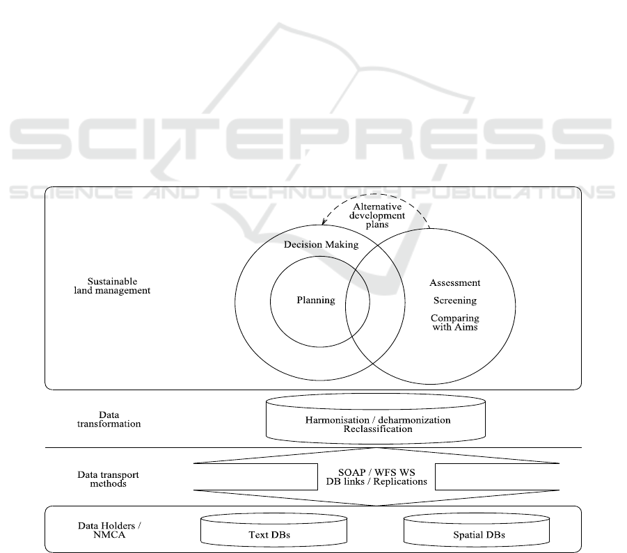
Figure 1 shows how alternative development
plans are used for each new iteration in decision-
making. This correlates with Patton’s ‘The Classical
Rational Problem-Solving Process’: 1) Define the
Problem, 2) Determine Evaluation Criteria, 3)
Identify Alternative Policies, 4) Evaluate Alternative
Policies, 5) Select the Preferred Policy, 6)
Implement the Preferred Policy (Patton et al., 2013).
Information for decision-making can be
harvested in automated way using SDI as data
source.
Another article states that – Decision-making
processes in strategic planning are very complex and
decisions can be made in many levels. The major
problem is to create harmonized automated process
where decisions can be made in any level (Pinson,
Louçã and Moraitis, 1997).
Figure 2 shows the distributed Sustainable land
management approach across different management
levels, where feedback is implemented at every level
of development. The process goes in a spiral.
Figure 1: Information system’s architecture for land development (Holms et al., 2017).
Linking Environmental Data Models to Ecosystem Services’ Indicators for Strategic Decision Making
171
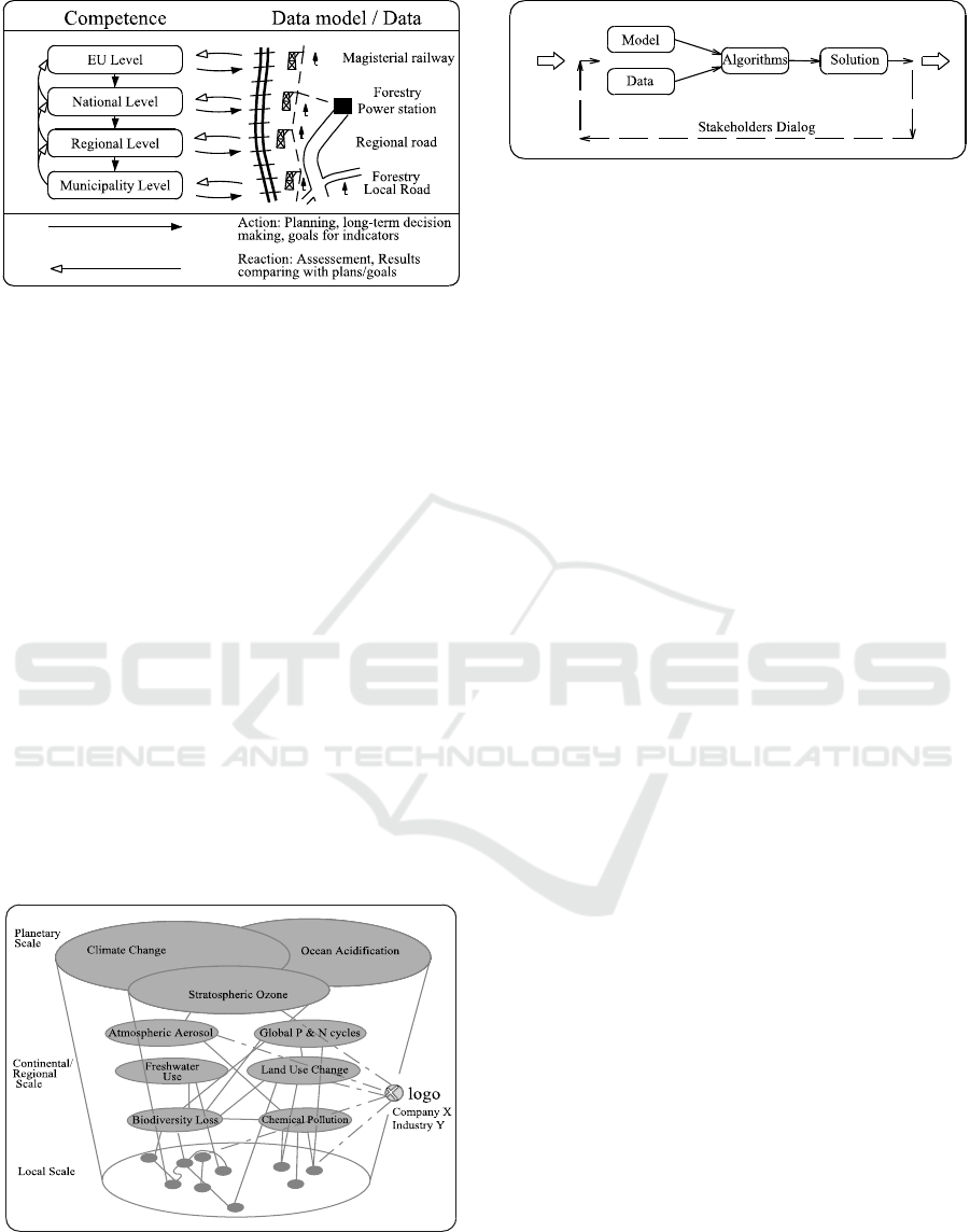
Figure 2: Distributed decision making in Sustainable land
management.
A similar situation is with Ecological issues (Fig.
3) where companies, corporations, industries interact
with environment in non-linear way and on different
scales (Whiteman et al., 2013). Alyoubi points to the
importance of Knowledge Management. Nowadays
Decision Support Systems is an inalienable tool for
Complex Decision Making in knowledge-based
solutions (Alyoubi, 2015).
Knowledge can be treated as a combination of
united data model and data. For example, filled with
data INSPIRE (EU Directive, 2007) data themes are
a good example of Knowledge.
Figure 4 (Cano et al., 2017) describes
Stakeholders Dialogue. There is described classical
minimalistic rational planning process scheme,
where there is data collection (Model, Data), data
processing/analyzing (Algorithms), next iteration’s
plan and results from previous iteration (Solution)
and reaction as ‘Stakeholders Dialog’. Big bullets
from left and right shows, that this is a
spiral/iterative process.
Figure 3: Levels of Ecological issues (Whiteman, Walker
and Perego, 2013).
Figure 4: Decision support system framework diagram
(Cano et al., 2017).
2.1 Classification
It is relatively easy to make links between two data
models. But in our case no harmonized data model
exists for ES. There are at least three major
classifications for ES:
Common International Classification of ES
(CICES);
Classification from Millennium Ecosystem
Assessment (MEA2005);
‘The Economics of Ecosystems &
Biodiversity’ (TEEB) classification.
In practice not all of the ES indicators can
directly be aligned with INSPIRE data model. For
example, indicator (from Table 1) ‘Number of traps
for the river lamprey’ can not be linked with
INSPIRE data model without additional information.
This additional, mostly textual information, is
available in other stakeholder’s registers in
unharmonized way. In long term it would be more
beneficial if this additional information was
identified, harmonized, standardized and available in
machine readable format, for example, in XML or
JSON formats.
In Europe, as in other places, SDI is in
implementation process. In Europe this process is
provided by INSPIRE directive (EU Directive,
2007), which describes advanced data model for
environmental data. The list of land use categories to
be used in INSPIRE Land use are specified by
Hierarchical INSPIRE Land Use Classification
System (HILUCS). The HILUCS is applicable for
existing and planned land use, and is available in
human and machine readable way. In the future this
classifier may be supplemented to ensure
harmonization with ES classification.
2.2 Ecosystem Services Assessment
Benjamin Burkhard tried to get spatial and statistical
information on the capacities of different land cover
types to provide ES. As a data source there was used
spatial (CORINE Land Cover and Land Use) and
ICEIS 2018 - 20th International Conference on Enterprise Information Systems
172
Table 1: Example of Indicators from Deliverables of LIFE Project realized in Latvia – “Assessment of ecosystems and their
services for nature biodiversity conservation and management” (Mapping of ecosystems and their services in Saulkrasti and
Jaunķemeri pilot areas, 2016).
Section
Division
Group
Class
Indicator
Provisioning
Nutrition
Biomass
Wild plants and their outputs
Yield of wild berries
Wild animals and their outputs
Number of traps for the river
lamprey
Materials
Biomass
Fibres and other materials from
plants for direct use or processing
Potentially harvestable timber
volume
Fibres and other materials from
plants for direct use or processing
Herbs
Energy
Biomass-based
energy sources
Plant-based resources
Potentially harvestable timber
volume for bioenergy
textual information. Spatial information was used to
reference textual/statistical information. To make
assessment, the spatial assessment matrices for every
Land Use type were constructed (to reference textual
data). After that ‘Matrix for the assessment of the
different land cover types‘ capacities to provide
selected ecosystem goods and services’ was built,
where in X axis there are Land Cover types and in Y
axis ES (Burkhard et al., 2009).
The authors of the article have similar idea, but
as data source it would be more convient to use
INSPIRE data and in Latvia adopted ES
classification. This classification was introduced in
LIFE project LIFE13 ENV/LV/000839 -
“Assessment of ecosystems and their services for
nature biodiversity conservation and management”
which is being followed in Latvia (LIFE
EcosystemServices, no date). Indicators were
classified and published for two pilot areas for ES
mapping purpose. An example of Provisioning ES
indicators is available in Table 1.
3 PROPOSAL
There is still no harmonized classification of ES is
available. Every stakeholder has their own
classification of ES and assessment methods which
makes it inconvenient to use this data to make some
cross border research, planning or decision making.
Cross boundary common understanding of
classifications and assessment methodologies can
significantly simplify the perception of the same
problem by experts from different countries.
Already now it is possible to build Information
Systems (IS) for strategic decision making in Land
management to ensure Sustainable Land
Development (Fig. 1), but there are obstacles in
scalability. This is due to the fact that there are many
ES classifiers and it is not always possible to
harmonize data from different classifiers.
The same problems are with SDI. In Europe
there is approved INSPIRE, but other world
countries have their own standards and it is not
always possible to harmonize spatial data between
standards.
In addition, an issue arises with linking
Ecosystem’ Services indicators to SDI. In many
cases it is possible to harmonize classifiers and to
link indicators to data model from SDI, but on cross
boundary scale there is a risk of partners using their
own classifiers, that have not been harmonized.
Table 2: To ensure harmonization with Ecosystem
Service, potentially extensible INSPIRE themes.
Potentially extensible
INSPIRE theme
Ecosystem Services Indicator
Species distribution
Yield of wild berries
Agricultural and
aquaculture facilities
Number of traps for the river
lamprey
Land Use and Energy
resources
Potentially harvestable timber
volume
Species distribution
Herbs
Land Use and Energy
resources
Potentially harvestable timber
volume for bioenergy
At Pan-European level it is strongly advisable for
strategic decision making in land management for
spatial referencing to use INSPIRE themes (for
example Land Use, but not only) with linked data
from ES Indicators. In their turn Indicators should be
harmonized in INSPIRE manner. And if Indicators
concept gets enough maturity, INSPIRE themes
should be supplemented with ES classification.
Linking Environmental Data Models to Ecosystem Services’ Indicators for Strategic Decision Making
173

Table 2 shows an example of potential linkage
between INSPIRE theme and Ecosystem Services
Indicator.
The proposal is - at International Organization
for Standardization (ISO) level to develop
standardized and detailed (incl. Indicators)
Ecosystem Services Classifier and to extend
INSPIRE specification with standardized Ecosystem
Services detailed classifier.
4 CONCLUSIONS
At the moment standardized Ecosystem Services
Classifier do not exist, as well it is not harmonized
with INSPIRE or another SDI data model.
In Europe at municipality, regional and national
level it is possible to create distributed strategic
decision making IS for land management and as data
source using data from INSPIRE data model
harmonized with Ecosystem Services’ Indicators and
if necessary appended it with standardized specific
textual information from stakeholder’s data stores.
For facilitating data exchange process in
distributed strategic decision making IS for land
management on Pan-European level it is
recommended:
to develop standardized and detailed (incl. ES
Indicators) Ecosystem Services’ Classifier and
approve it at ISO level;
to extend INSPIRE specification with
standardized Ecosystem Services’ detailed
classifier.
REFERENCES
Alyoubi, B. A. 2015. Decision Support System and
Knowledge-based Strategic Management. In Procedia
Computer Science. Elsevier, pp. 278–284.
Bennett, E. M. et al. 2015. Linking biodiversity,
ecosystem services, and human well-being: three
challenges for designing research for sustainability. In
Environmental Sustainability. Elsevier, pp. 76–85.
Braat, L. C. and de Groot, R. 2012. The ecosystem
services agenda: bridging the worlds of natural science
and economics, conservation and development, and
public and private policy. In Ecosystem Services, pp.
4–15.
Burkhard, B. et al. 2009. Landscapes‘ Capacities to
Provide Ecosystem Services – a Concept for Land-
Cover Based Assessments. In Landscape Online.
Cano, E. L. et al. 2017. A strategic decision support
system framework for energy-efficient technology
investments. In TOP. Springer Berlin Heidelberg,
25(2), pp. 249–270.
Common International Classification of Ecosystem
Services (CICES). No date. Available at:
https://biodiversity.europa.eu/maes/common-
international-classification-of-ecosystem-services-
cices-classification-version-4.3. (Accessed: 22
November 2017).
Ecosystems and human well-being. 2005. Washington,
D.C.: Island Press.
EU Directive. 2007. Directive 2007/2/EC of the European
Parliament and of the council of 14 March 2007
establishing an Infrastructure for Spatial Information
in the European Community (INSPIRE). In Official
Journal of the European Union, 50, pp. 1–14.
Available at: http://eur-lex.europa.eu/LexUriServ/
LexUriServ.do?uri=OJ:L:2007:108:0001:0014:EN:PD
F. (Accessed: 22 November 2017).
Folke, C. et al. 2016. Social-ecological resilience and
biosphere-based sustainability science. In Ecology and
Society. The Resilience Alliance, Vol.21, Iss.3, Art.41.
Holms, J. et al. 2017. Ecosystem Provisioning Services
Automated Valuation Process Model for Sustainable
Land Management. In Procedia Computer Science,
104, pp. 65–72.
LIFE EcosystemServices. No date. Available at:
https://www.daba.gov.lv/public/eng/projects/life_ecos
ystemservices/. (Accessed: 22 November 2017).
Mapping of ecosystems and their services in Saulkrasti
and Jaunķemeri pilot areas. 2016. Available at:
http://ekosistemas.daba.gov.lv/public/eng/deliverables
_and_publications1/ecosystem_services_mapping/.
(Accessed: 22 November 2017).
Patton, C. V. et al. 2013. The book: Basic Methods of
Policy Analysis and Planning(3
rd
edition). Pearson
Education.
Pinson, S. D., Louçã, J. A. and Moraitis, P. 1997. A
distributed decision support system for strategic
planning. In Decision Support Systems. North-
Holland, 20(1), pp. 35–51.
The Economics of Ecosystems & Biodiversity (TEEB).
No date. Available at: http://www.teebweb.org/
resources/ecosystem-services/. (Accessed: 22
November 2017).
United Nations. General Assembly. 1987. Report of the
World Commission on Environment and Development.
Whiteman, G., Walker, B. and Perego, P. 2013. Planetary
Boundaries: Ecological Foundations for Corporate
Sustainability. In Journal of Management Studies.
Blackwell Publishing Ltd, 50(2), pp. 307–336.
ICEIS 2018 - 20th International Conference on Enterprise Information Systems
174
