
Perception and Utilization of Urban Corridor as Public Space in
Medan, Indonesia
Wahyuni Zahrah
1
, Achmad Delianur Nasution
1
, and Novi Rahmadhani
1
1
Department of Arcitecture, Faculty of Engineering, Universitas Sumatera Utara, Medan, Indonesia
Keywords: public space, urban corridor, perception, Medan, Indonesia
Abstract: The paper discuss the perception and utilization of street corridors as a public space. The study took place in
three commercial corridors in Medan. They are Asia Corridor, Kapten Muslim Corridor, and Ring Road
Corridor. The objective of the study is to explain and explore the planning and design process, the physical
quality, the perception of the users, and the utilization of the corridors. The interview with the Government
of Medan was carried out to get the information about the process of urban corridors planning and design.
The physical quality of the corridor was mapped and recorded through a visual survey. The surveyors
interviewed the users to collect the facts about the intensity of the activity and people perception of the
corridors. The analysis used mix method that consisted of qualitative and quantitative data. The study found
that the corridors were not planned in a detailed guideline by city government. The utilization was driven by
user’s initiatives, both the building owners and the street vendors. The corridors was not functioned
optimally as public space due to the lack of facility and quality. In general, people thought that it is not
allowed to use public space for street vending and vehicles parking area. However, they do not have any
proper choice in the urban space to meet their needs, so they use the urban public space individually.
1 INTRODUCTION
There are several types of public open space, such as
parks, squares, space between buildings, and streets.
In the past researches the authors have explored the
public life of parks and squares in Medan and other
towns in Sumatera Utara province. The investigation
showed that the using of the public spaces was
intensive, while the quality of the design was not so
good (Nasution dan Zahrah, 2015). However, the
parks and squares cannot be found easily, due to the
lack of land-availability for public use. There is a
kind of other public open space that always exist in
the urban area: the street. The street is a linear-form
public open space. The row of buildings along the
street shape a corridor and accommodate people
activities (Zahrah et al, 2016; Zahrah and Lie, 2016).
A corridor is more than just a circulation path. It
can be a community space where people engaged
(PPS, 2008). An urban corridor, which consists of
front yard of buildings, pedestrian path, green path
and streetscape, can be a melting point for
community to interact each other. Some studies
investigated the utilization of street corridor in
Indonesia based on several point of views.
Widjajanti (2016) analyzed the characters of space
occupied by street vendors in a corridor of an
education area. Uniaty (2017), that reviewed a street
in Northern Jakarta, highlighted the importance of
considering the street users. Darmoyono and Tanan
(2017) stressed their study to community
participation in corridor planning and design. To the
best knowledge of the authors, there is no study
about how people view the corridor in relation with
its actual quality and their needs, especially in
Medan, Indonesia. It is necessary to explore how the
urban space, shop houses corridor in this case, being
planned, perceived and used by people. Thus, it can
be understood the way people occupying the urban
space. This study would be a reference to respond to
local people needs in the urban planning and design
process.
2 METHOD
The study was located in three shop houses corridors
in Medan, Indonesia. The corridors were Jalan Asia,
Jalan Kapten Muslim, and Ring Road. Jalan Asia
346
Zahrah, W., Nasution, A. and Rahmadhani, N.
Perception and Utilization of Urban Corridor as Public Space in Medan, Indonesia.
DOI: 10.5220/0010095903460350
In Proceedings of the International Conference of Science, Technology, Engineering, Environmental and Ramification Researches (ICOSTEERR 2018) - Research in Industry 4.0, pages
346-350
ISBN: 978-989-758-449-7
Copyright
c
2020 by SCITEPRESS – Science and Technology Publications, Lda. All rights reserved
was the oldest corridors, while Ring Road was the
newest construction.
This research was a descriptive exploratory study
since it means to explain and explore how the
corridors planned, perceived and used. The data
collected was qualitative and quantitative. The
planning and design process of the corridors was
investigated through the interview with Medan
Government, as well as the interview with corridors’
users and field observation. The physical quality of
the urban space was collected by using the visual
survey method. The surveyors mapped and recorded
the related elements, such as site plan, pedestrian
path, and street furniture. The intensity of utilization
was identified through the questionnaire. There were
189 respondents that found in the corridors and
agreed to participate in the survey. They were
chosen randomly along the corridor by considering
their activities, such as the pedestrians, the street
vendors, the customers of shop house and street
vendors, and the shop houses owners. The interview
to users was carried out to explore how they
perceived and used the space. The way they used the
urban space was recorded through behavioural
mapping, based on the photographs, observation, on-
site sketching, and video recorder.
3 RESULT AND DISCUSSION
The results will be discussed based on variables that
studied. They are the planning and design process of
corridor, the physical quality, the users perception,
and the way people use the corridor.
3.1 The Design and Planning Process of
the Corridor
Based on the interview to the official of Dinas
Perumahan Kawasan Pemukiman dan Penataan
Ruang (Housing, Settlement and Urban Design
Services) of Medan Municipality, it can be
concluded that the City Government did not have
and implement the detailed planning of the corridor
that could guide the design and control the growth.
The existing regulation was a general plan that
regulates the urban space in two dimensions, such as
building setback, and building coverage. There was
no regulation to manage and determine the building
frontage and mass, the pedestrian performance, the
vegetation arrangement and the land function. As a
consequence, the corridor grew spontaneously
without control, following the individual needs. The
field survey showed that the building owners did not
always obey the regulation of the setback and
building coverage. In one area the buildings had a
setback, while in the other area was adjacent to the
sidewalk.
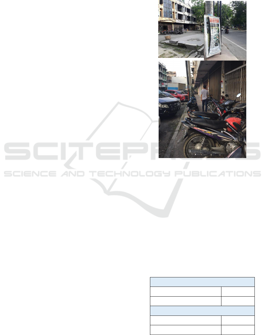
Figure 1. The quality of the corridor: pedestrian path
obstruction by signage and parking
3.2 People’s Perception to Corridor
Perception is one of the significant parts in the urban
design. By recognizing the people perception, their
needs can be identified well (Carmona, 2004;
Nasution and Zahrah, 2014). The study tried to
investigate people perception of the corridor by
asking the users. Most of respondents were males,
(63.49 %), productive age (18 – 45, 87.31 %),
entrepreneur (35.98 %), married (50.26 %), owning
private vehicles (84.13 %) and use their vehicles as
the transportation mode (79.90 %) (Table 1).
Table 1. Respondents’ characteristics
Gende
r
a. Female
36.51%
b
. Male
63.49%
Ag
e
a. 18 - 25
35.98%
b
. 26 - 35
26.46%
Perception and Utilization of Urban Corridor as Public Space in Medan, Indonesia
347

c. 36 - 45
24.87%
d. 46 - 55
9.52%
e. 56 - 65
3.17%
f. > 65
0%
J
ob
Entrepreneu
r
35.98%
Government emplo
y
ee
15.87%
Governmen
t
-corporate
emplo
y
ee
7.94%
Private emplo
y
ee
8.47%
Professional/self-employee
1.59%
Others
30.16%
M
arital Status
a. Marrie
d
50.26%
b
. Not marrie
d
49.74%
M
onthl
y
expenses (million IDR)
a. < 5
58.73%
b
. 5 - 10
29.63%
c. 10 - 15
10.05%
d. 15 - 20
1.59%
e. 20 - 25
0%
f. > 30
0%
Do you have private vehicles?
a. Yes, motor cycle
59.26%
b
. Yes, automobile
24.87%
c. nothin
g
15.87%
What is the transportation mode you
use?
a. motor c
y
cle
55.56%
b
. automobile
24.34%
c. public transpor
t
9.52%
d. Online -
p
ublic
motorcycle
4.76%
e. Online taxi
3.17%
f. Trishaw
0.53%
g
. Walkin
g
2.12%
With the low physical quality of the corridors,
particularly if compared to the good urban corridor
standards (PPS, 2008), and the needs to public life
rather than public space (Banerjee, 2001), the
majority of respondents perceived the corridor as
‘good’ or ‘very good’, mainly at the aspects of
security, cleanliness, night lighting, traffic,
liveliness, and comfort. Meanwhile, the shade of
trees and the attractiveness factors were perceived as
‘not good’ (Table 2). As the security and comfort
became the crucial consideration they needed
(Crewe K, 2001), the respondents used the space for
their needs, though the quality of the corridor was
not good enough. The conditions seemed relating to
the activities occurred. In the study area, the optional
or recreational activities were rarely found, which
connected to the quality of the place (Gehl, 2002).
Table 2. People perception of the quality of corridors
Variables very
goo
d
good Less
goo
d
bad Very
b
a
d
Security 4,8 38,2 38,2 2,4 0
Cleanline
ss
0,9 54,6 35,3 8,7 0,5
Li
g
htin
g
5,3 66,7 22,2 5,3 0,5
Shady
trees
7,3 38,2 36,7 15,5 1,9
Beauty/at
tractivene
ss
1,5 27,5 49,3 19,3 2,4
Livelines
s
17,4 72,9 9,7 0 0
Traffic 5,3 55,6 33,9 4,4 0,9
Comfor
t
3,0 62,6 30,3 3,5 0,5
3.3 The Way People using the Corridor
The land use in the shop houses corridor was mostly
commercial function, such as retails, restaurants, or
services purpose. ‘Ruko’ as the acronym of ‘rumah’
(house) and ‘toko’ (shop) did not always present in
all corridor, except in the oldest Area of Jalan Asia.
The new shop houses, such as in Ring Road
Corridor, was only functioned as commercial uses,
not as a house where the family stayed and lived.
The owners or the tenants of the buildings,
particularly in Kapten Muslim and Ring Road
Corridors, lived in the other buildings, not in the
‘shop houses’. In this area, we could find the largest
portion of the empty shop house, the buildings
without occupants. In contrast, most of the shop
houses in Jalan Asia was functioned as a ‘shop’ and
also as a ‘house’. However, the newer the corridor,
the larger activities occurred. Jalan Kapten Muslim
Corridors was the liveliest zone compare to the two
other corridors. In here, street vendors operated from
morning until night. We could see that at the street
ICOSTEERR 2018 - International Conference of Science, Technology, Engineering, Environmental and Ramification Researches
348
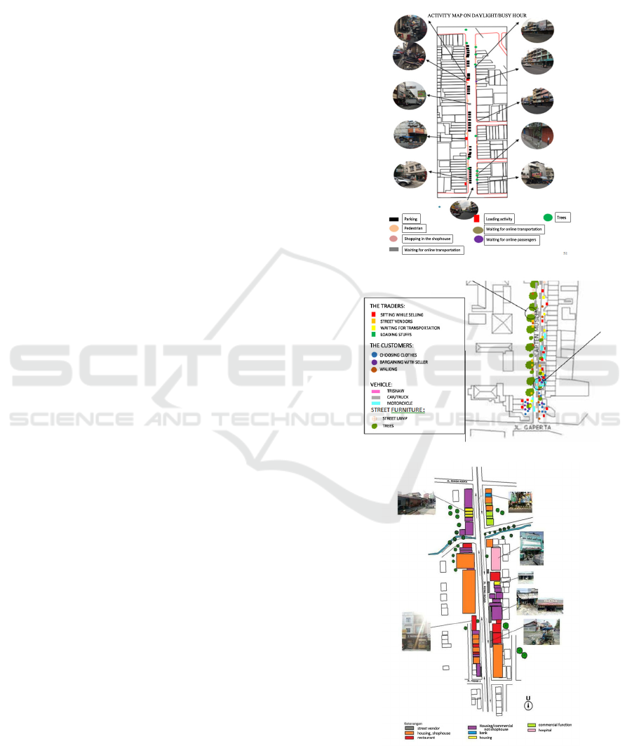
vendor spots along the corridors, the community
activities took place. The condition related to the
lack of communities’ facility along the pedestrian
path; there was no comfort spacious side walk or
benches. Meanwhile, the informal traders provided
sitting place and food. In this place people interacted
each other, at least between customers and the
tradesmen. In the other part of corridor, including
the pedestrian way, it was very rarely people
walked. It might correlate with the facts that the
majority of people was the vehicles-dependence
community, more than 80 % of them did not walk,
but used their private vehicles, mostly motorcycles.
Nevertheless, the interview with the pedestrians
showed that they ever said greeting to the other
people while walking. This fact indicated that
walking could stimulate interaction and social
contact. Since it was very rarely to find people walk,
the interaction happened in the street vendor’s
points.
How the vendors used the space? There was no
regulation or convention. They just came, chose a
location, and the place became ‘theirs’. The
favourite place was the shady spot under the tree. In
some cases, the vendors bargained with the building
owners to use the space in front of the building,
including the sidewalk and street, a part of public
space that should be ‘not for sale’. They put their
equipment in the buildings’ front yard, and or on the
pedestrian path, and or on the street’s boundary.
They sold something, having repeated customers,
and did not want to move from the place. The
vendors also said that their activities did not injure
the pedestrians, nor the traffic. This condition was
different with customers’ opinions. They said that
they knew it is not allowed occupying pedestrian
path for parking.
“... We place the stalls on the street, cashier, and
benches for customers on the sidewalk... we use only
as wide as one lot of a shop house.... ” (R, street
vendor in Jalan Asia)
“... We choose the shady place under the tree... it is
safe and secure here, never happens a crime ... we
don’t want to move from here. It has been a long
time we trade, it is the only our income resource...
“(A, street vendor in Jalan Kapten Muslim)
The other utilization of the urban space in the
corridor was the parking lot (Figure 3). Since the
buildings had no setback, and the presence of the
informal merchants on the sidewalk and or the edge
of the street, there was no allocation lot for parking.
As a result, the sidewalk – which was very rarely
being used by the pedestrians – was occupied by
cars or motorcycle for parking. The fact was contrast
with their most opinion that “agree that parking on
the pedestrian path injures the pedestrians” and
“agree that parking on the street bothers the traffic”.
(i)
(ii)
(iii)
Figure 2. Activities in the corridors (i) Asia (ii) Kapten
Muslim (iii) Ringroad
Perception and Utilization of Urban Corridor as Public Space in Medan, Indonesia
349
Figure 3. The occupation of the corridor: parking and
street vendor
4 CONCLUSIONS
The study showed that there was a gap between the
community’s knowledge and their practical in using
the urban space, the urban corridor in this case. They
knew about how the space should be used as a
public space, but there was no choices to fulfill their
needs, mostly for the economic interest and the
‘vehicle-dependence trap’. Furthermore, there was
no proper plan and design to accommodate and
anticipate the dynamics of the urban community.
The urban corridor seemed to be ‘a container of
vehicles and stalls’, rather than a public space,
where people engage in a mutual interaction. The
urban space was failed to provide the demand. These
findings confirmed the other researches that the
main problems in the urban corridor was the lack of
appropriate pedestrian path and the ‘attack’ of
vehicles and street vendors (Zahrah et al, 2016;
Tanan, 2017) because of the absence of the good
design, the weakness of regulation control, and the
shortage of community’s awareness. Since the
respondents of the survey were the people found in
the corridors, the study just describes the perception
based on them. It is much recommended to continue
this study by a household survey, so that it could be
obtained a more comprehensive picture of people
perception about the utilization of the corridor,
particularly in Medan, Indonesia.
ACKNOWLEDGEMENTS
The authors would like to acknowledge that the
present research is supported by Ministry of
Research and Technology and Higher Education
Republic of Indonesia. The support is under the
research grant DRPM Kemenristekdikti of Year
2018 Contract Number 90/UN5.2.3.1/PPM/KP-
DPRM/2018.
REFERENCES
Banerjee T. 2001. The future of public space: Beyond
invented streets and reinvented places. Journal of the
American Planning Association vol 67 no. 1 : 9-24
Carmona M, 2004 Public Places Urban Spaces Oxford:
Elsevier and Architectural Press
Crewe K , 2001. Linear parks and urban neighborhoods: A
case study of the crime impact of the Boston South-
west corridor. Journal of Urban Design Vol 6 no. 3:
245 – 264
Gehl J 2002 Public Space and Public Life City of
Adelaide. City of Adelaide
Nasution AD, Zahrah W, 2014. Community perception on
public open space and quality of life in Medan.
Indonesia. Procedia - Social and Behavioral Sciences
153: 585-594
Nasution AD, Zahrah W 2015. Urban Design Guidelines
for Shophouse: A Temperature Modificaion
Approach. Procedia-Social and Behavioral Sciences
179: 308-317
Tanan N, Darmoyono L. 2017. Achieving walkable city in
Indonesia: Policy and responsive design through
public participation. AIP Conference Proceedings
1903(1):080010 (2017) doi: 10.1063/1.5011598
Uniaty Q. 2017. Pedestrian Space Characteristics Analysis
on Kyai Tapa-KH Hasyim Ashari Street Corridor,
West Jakarta. Aceh International Journal of Science
and Technology 6 (3): 153-165
Widjajanti, 2016. The Space Utilization by Street Vendors
Based on the Location Characteristics in the Education
Area of Tembalang, Semarang. Procedia - Social and
Behavioral Sciences 227 : 186 – 193
Zahrah, W, Aulia, DN, Marpaung, Beny OY. 2016.
Koridor Ruang Kota Layak Huni: Budaya
“Merampas” Ruang Publik? Prosiding Temu Ilmiah
2016 IPLBI : E 081-088
Zahrah, W, dan Lie, S., 2016, People and urban space in
Medan: an environment behaviour approach.
Environment-Behaviour Proceedings Journal Vol 1
Issue 1 368-374
ICOSTEERR 2018 - International Conference of Science, Technology, Engineering, Environmental and Ramification Researches
350
