
Temporal Distribution and Causes of Forest and Land Fires in North
Sumatera Province, Indonesia
A. S. Thoha
1
, Onrizal
1
and P. Patana
1
1
Faculty of Forestry, Universitas Sumatera Utara,, Jalan Tridarma Ujung No. 1 Medan, Indonesia
Keywords: Forest and land fires, hotspot, spatial analysis, fire period.
Abstract: Determining the characteristic of fires and fire-prone areas will help in low-emission land-based development
planning. This study aims to identify temporal patterns and causes of forest and land fires in North Sumatra.
The temporal pattern was determined by spatial analysis and descriptive of rainfall and fire hotspot during
2001-2017. The causes of fire were determined by observation and in-depth interview on the location of the
indication of fire based on hotspot density analysis result. Based on temporal distribution, the hotspot of fire
increases every five years. Peak forest and land fires occurred in two periods each year namely February-
March and June-August. The causes of forest and land fires in North Sumatra were not same across regions.
The most common causes were fires due to land clearing activities for plantation areas, whether coffee
plantations, rubber plantations or oil palm plantations. Other causes were grazing, negligence of the
community, conflict companies and for customary reasons.
1 INTRODUCTION
Recurrent forest and land cultivation incidents
and increasingly severe impacts should receive the
attention of all parties. In Indonesia, forest and land
fires occur repeatedly almost every year during the
dry season with different frequency and level of risk.
The impacts of forest and land fires will be worse
when they occur on peatlands. Peatland fires in
1997/1998 that occurred El Nino in Indonesia,
contributing 13-40% of emissions from global
emissions. (Page 2002, Harrison, et al. 2009 and
Langmann et al., 2009). According to data from the
National Disaster Management Agency (BNPB) of
forest and land fires in 2015 estimated to result in
losses of 221 trillion rupiah (Kompas.com, 2016). In
the long run, the impact of fires resulted in global
warming, loss of biodiversity and desertification
(Goldammer et al., 2006).
North Sumatera Province is one of the prone areas
of forest and land fires in Indonesia. In North
Sumatra, there are thousands of hectares of peatland
and natural reed grasslands and critical lands that are
prone to fire during the dry season. In 2013, the area
of critical land in North Sumatra reached 1,069,467
hectares (KLHK, 2017). Extensive critical land is
located in Lake Toba Water Dump Area (DTA)
which reaches 248,000 hectares or 45% of the total
DTA area (beritasatu.com, 2016). Critical land in the
form shrubs and reed are generally not managed
generally will be a source of fire (Thoha et al 2014,
Prasetyo et al 2016).
Development of Early Warning Systems for
Community-based Forest and Land Fire is urgently
needed to find solutions from today's centralized and
costly systems and encourage people to play a more
active role in their own protection. According to
UNISDR (2009), the community-based early warning
system is a community-centered system consisting of
four key elements; (i) knowledge of risk (ii)
monitoring, analyzing and forecasting hazard threats,
(iii) communication or dissemination of alert
messages and warnings; and (iv) local capacity to
respond to warnings received. According to de Leon
(2009) Community Early Warning System is an
operational structure that allows residents to take
steps to minimize the impact of natural disasters.
Determining the characteristics of fire in the form
of temporal pattern and the cause of fire is an
important step in order to build early warning system.
Determination of fire characteristics will assist in the
planning of development of low-emission land-based
areas. This study aims to identify the temporal
distribution and causes of forest and land fires in
North Sumatra.
Thoha, A., Onrizal, . and Panata, P.
Temporal Distribution and Causes of Forest and Land Fires in North Sumatera Province, Indonesia.
DOI: 10.5220/0010088300610066
In Proceedings of the International Conference of Science, Technology, Engineering, Environmental and Ramification Researches (ICOSTEERR 2018) - Research in Industry 4.0, pages
61-66
ISBN: 978-989-758-449-7
Copyright
c
2020 by SCITEPRESS – Science and Technology Publications, Lda. All rights reserved
61

2 MATERIAL AND METHOD
2.1 Material
The materials in this research were hotspot map 2001-
2017 from MODIS satellite (Moderate-resolution
Imaging Spectroradiometer), map of district
administration boundary and monthly rainfall. The
tool in this research consisted of data collection tools
and data analysis tools. Field data retrieval tools
included GPS, camera and voice recorder. Data
analysis tool was Spreadsheet software and GIS
Software.
2.2 Method
2.2.1 Data Collection
Hotspot data from Terra / Aqua satellites with
MODIS (Moderate-resolution Imaging
Spectroradiometer) sensor of 2001-2017 were
obtained from Fire Information for Resource
Management System (FIRMS) which can be accessed
free of charge at https://earthdata.nasa.gov/data/near-
real-time data/firms/active-fire-data. Field rainfall
data was obtained from Indonesian Agency for
Meteorology, Climatology and Geophysics Region I
Medan. To determine the location of the survey for
observation and groundcheck obtained based on input
from Manggala Agni Natural Resources
Conservation Center of North Sumatra and spatial
analysis results based on villages with high density
hotspots. For the collection of fire characteristic data
obtained from the observation and recording of
community activities at the site of the fire through
interviews with the community about the history of
the fire, the cause of fire and the practice of the
community to prepare the land by burning. Public
knowledge of the causes of fires was obtained
through indepth-interview. Interview sources were
selected through snowballing method with the first
resource person becomes the key person in
determining the next response. (Bungin, 2010).
2.2.2 Temporal Analysis of Forest and Land
Fires
Identification of forest and land fire characteristics
was determined by determining the temporal pattern
of fires conducted by field rainfall data analysis and
number of annual hotspots and monthly hotspots.
Hotspots with level above 50% were used to analyze
fire analysis because they were categorized as
hotspots that fall within the nominal and high
category (Giglio et al., 2015) and vigilant and
immediate action of fire prevention in the field
(LAPAN 2016) was required. Thoha et al. (2014)
found that Terra Aqua satellite hotspot (MODIS) with
level above 50% illustrates a strong relationship with
fire activity in the field.
2.2.3 Analysis of Causes of Forest and Land
Fire and Local Community Knowledge
Descriptive and tabulation analysis was used to find
the cause of forest and land fires in relation to
community activities. Community activity data
analyzed was obtained by observing and recording
community activities at the site of the fire through
interviews about the history of fires, the causes of
fires and the practice of preparing the land by
burning. The location of interview was determined
from the village that has a hotspot and
recommendation from the local government about
prone villages to forest and land fires. The result of
spatial analysis and recommendation from institution
that play a role in forest and land fire control was 25
villages in six districts for field observation and
interview.
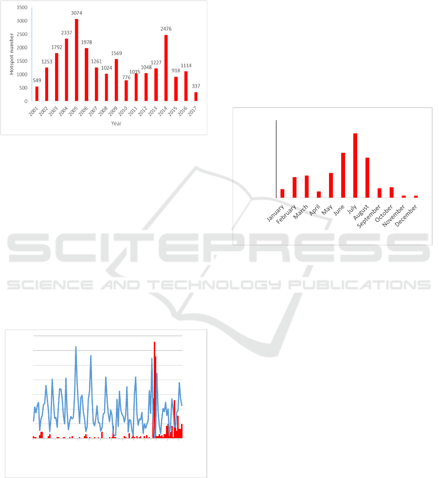
3 RESULT AND DISCUSSIONS
North Sumatra Province is one of the provinces
whose territory occurs forest and land fire in the dry
season. Based on fire historical data from hotspot
MODIS with level confidence more than 50% (C>
50), the distribution of hotspots yearly and monthly
in North Sumatra province can be seen in Figure 1
and Figure 2.
The hot spot observed from satellites in North
Sumatra Province for 17 years (Figure 1) shows that
there is a steady increase in hotspots every five years.
In the first five years (2001-2005) the hotspot
increased in 2004 and 2005. Furthermore, the
hotspots increased to the highest number in 2009 and
2014. This pattern is not in accordance with climatic
conditions in Indonesia in general where in the years
of anomalies climate with below average rainfall or
El Nino (2002 and 2015) the number of hotspots is
not too high number. The highest hotspot in North
Sumatra occurred in 2005 where in general the
ICOSTEERR 2018 - International Conference of Science, Technology, Engineering, Environmental and Ramification Researches
62
3,42
8,06
8,67
2,51
9,65
17,45
24,92
15,59
3,74
4,18
0,92
0,88
0,00
5,00
10,00
15,00
20,00
25,00
30,00
PercentageofHotspot(%)
Month
0
10
20
30
40
50
60
70
80
90
100
0
100
200
300
400
500
600
700
jan/06
out/06
jul/07
abr/08
jan/09
out/09
jul/10
abr/11
jan/12
out/12
jul/13
abr/14
jan/15
out/15
Hotspotnumber
Rainfall(mm)
Month‐ year
climatic conditions in Indonesia are not in El Nino
condition at high level.
Figure 1. Distribution of hotspots percentage per year in
North Sumatra Province
Analysis of hotspots on a monthly basis shows
that for almost 17 years, the highest percentage of
hotspots occurred in July at 24.92%. This means that
fire activity in a year is potentially very large in July.
The hotspots in North Sumatra Province have two
periods of increasing both the number and
percentage. The first period of hotspots increases
from January to April while the second period is June-
August. Thoha et al. (2014) in Central Kalimantan
and Tata et al (2018) in Riau found a similar pattern
that hotspots increase in June-August each year.
Figure 2. Percentage of hotspots per month in North
Sumatra Province
From the analysis of hotspot distribution and
interviews with fire control stakeholders, there are
three groups of fire prone areas in North Sumatra. The
first is the highland and hilly areas in Karo District,
Toba Samosir and Simalungun. Second, peatland and
lowland areas, where fire-prone areas are scattered in
Labuhan Batu Utara, Labuhan Batu, Labuhan Batu
Selatan and Asahan. Third, hilly lowlands and
mineral soil areas, where fire-prone areas are found in
Padang Lawas, Padang Lawas Utara and Mandailing
Natal.
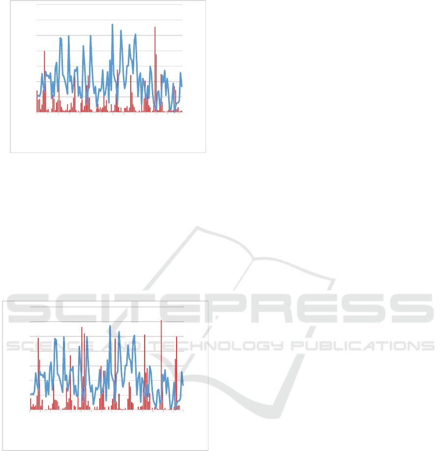
Based on the temporal analysis of rainfall and
hotspots, it is found that there are differences in
distribution patterns between the three groups of fire
areas. Figure 3 shows the temporal distribution
patterns of forest and land fires occurring in
mountainous areas.
Figure 3. Temporal distribution of rainfall (blue line) and
hotspots (red line) in mountainous areas of North Sumatra.
Temporal patterns of forest and land fires in upland
areas in North Sumatra indicate that hotspots increase
in number when rainfall decreases sharply (very low).
Generally, hotspots that describe the activity of fire
began to increase in June-August in 2006 - 2013 and
February - March in 2014-2015. This indicates there
are two periods of forest and land fires in the
highlands of North Sumatra.
Figure 4 shows the temporal pattern of hotspots and
rainfall of lowland and peatland areas in North
Sumatra. The temporal pattern in this second area
indicates that there are two periods of fire each year
between February-April and June-August for the last
10 years. In very low rainfall conditions, hotspots will
increase sharply.
Figure 4. Temporal distribution of rainfall (blue line) and
hotspots (red line) in lowland and peatlands in North
Sumatra Province
Temporal Distribution and Causes of Forest and Land Fires in North Sumatera Province, Indonesia
63
0
20
40
60
80
100
120
140
160
0
100
200
300
400
500
600
700
jan/06
set/06
mai/07
jan/08
set/08
mai/09
jan/10
set/10
mai/11
jan/12
set/12
mai/13
jan/14
set/14
mai/15
Hotspotnumber
Rainfall(mm)
Month‐ year
Temporal pattern of rainfall and hotspots
relationship in lowland non-peat hilly areas is
presented in Figure 5. Based on Figure 5, when
rainfall decreases sharply, there is a very high
increase of hotspots. In this region, temporal patterns
of precipitation and hotspots indicate that there are
two periods of fire activity (increased hotspots)
namely on February-March and June-August.
Figure 5. Temporal distribution of rainfall and hotspots of
precipitation and hotspots in non-peat hilly lowland areas in
North Sumatra Province.
Rainfall is very influential on the water content of
fuel, especially on peatlands. As rainfall increases,
peatlands will store large amounts of water so that the
water content of the fuel increases and is difficult to
be burned. When the rainfall decreases, the water
content of the peat decreases. Peat with low moisture
is very susceptible to burning. Taufik et al (2011)
explains that rainfall is very influential on the
dynamics of groundwater and groundwater levels.
The fluctuations of both are strongly influenced by
the dynamics of rain falling and wetting the soil. In
low rainfall seasons, water levels fall on critical
thresholds that cause highly flammable peatlands
(Wosten et al 2008).
An increase in the number of hotspots in June-
August is related to community activities that adjust
to the end of the dry season and the beginning of the
rainy season. In June, most of the livelihoods of
farmers have cleared and cleared land for cultivation.
Burned and cleaned fuels are allowed to dry for one
to two months. The following month is August at the
end of the dry season according to their habit of
burning biomass or waste from clearing the land.
Community activity related to clearing of land in the
dry season is also confirmed in the Someshwar et al
(2010) study which mentions that fires in Central
Kalimantan occurred during the dry season from May
to September. Farmers and planters cleared land
during that time, when the biomass was drier. Study
by Thoha et al. (2014) in Borneo Tenagh also found
that when rainfall decreases, hotspots increase
sharply, especially in August-October. The temporal
analysis of hotspots and rains is also in line with
predictions from local knowledge in Central
Kalimantan where in June-August most forest and
land fires occur (Thoha et al., 2018)
Forest and land fires in North Sumatra province
are closely related to community activities that adjust
to the period or season of fire. Results of interviews
with communities at various fire-prone sites or fire
prone locations were found to be the cause of fires as
presented in Table 1. According to Table 1, causes of
forest and land fires in North Sumatra are not same
across regions. The most common causes are fires due
to bushfire activity and land clearing activities for dry
agricultural land, coffee plantation and rubber
plantations. Other causes are grazing (Padang Lawas
Utara), neglect of the community, conflicts with
companies and customary reason (calling for rain).
Research conducted by [20] in Kapuas which
was area of peatland found that sources of land fires
are also from farmers and fishers. This is in
accordance with the descriptions in Table 1 that most
fires originate from community activities for dry
agriculture land clearing that many are found in
Simalungun, Labuhan Batu Utara, Tapanuli Utara,
Karo, Padang Lawas Utara and Dairi Districts.
Research conducted by [8] in Kapuas District, Central
Kalimantan, found the causes of forest and land fires
from human activities generally derived from shrubs
and grassland that are unmanaged land. This was
consistent with the results of research that the land of
shrubs and grassland are often become source of fire
which then spread to plantations and
forests as found in Simalungun, Padang Lawas and
Padang Lawas Utara.
0
200
400
600
800
1000
1200
0
100
200
300
400
500
600
700
jan/06
out/06
jul/07
abr/08
jan/09
out/09
jul/10
abr/11
jan/12
out/12
jul/13
abr/14
jan/15
out/15
Hotspotnumber
Rainfall(mm)
Month‐Year
ICOSTEERR 2018 - International Conference of Science, Technology, Engineering, Environmental and Ramification Researches
64

4 CONCLUSION
Based on temporal distribution, the hotspots of fires
in North Sumatra have increased considerably every
five years. There are two periods in a year where
hotspots are increasing from February to March and
June-August. The highest percentage of hotspots
occurred in July. The causes of forest and land fires
in North Sumatra are not the same across regions. The
most common causes are fires due to land clearing
activities for plantation areas, whether coffee
plantations, rubber plantations or oil palm
plantations. Other causes are grazing, negligence of
the community, conflicts with companies and
customary reasons.
Table 1. Causes of Forest and Land Fires in North Sumatra
Remark : 1 (present), 0 (absent), Sim (Simalungun), Tos (Toba Samosir, Huh (Humbang Hasundutan), Asa ((Asahan), Lau
(Labuhan Batu Utara), Kar (Karo), Plu (Padang Lawas Utara), Tau (Tapanuli Utara), Dai (Dairi),
Source: interview with villagers and BKSDA, 2016-2018
REFERENCES
Akbar A, Sumardi, Hadi R, Purwanto, Sabarudin MS.
2011. Study of fire sources and community respond for
peat swamp forest fire control in Mawas area Central
Kalimantan. Jurnal Penelitian Hutan Tanaman 8 (5):
287 – 300
Bungin B. 2010. Penelitian Kualitatif. Jakarta: Kencana
Prenada Media Group
De Leon JCV. 2009. Community early warning systems:
A strategy for the local management of disaster
reduction in Central America. Available online at
info.worldbank.org/etools/docs/library/230352/...2/Ca
s eStudy2.doc [accessed on 30 Nopember 2009]
Giglio, L. (2015). MODIS Collection 6 Active Fire Product
User's Guide Revision A. Department of Geographical
Sciences. University of Maryland.
Goldammer JG, Brady M, Csiszar IA, de Groot WJ, Justice
CO, Keenan T, Lorentz E, O’Loughlin K, Lynham TJ,
Oertel D, Stock BJ. 2006. Development of a Global
Wildland Fire Early Warning System within the
envisaged Multi-Hazard Global Early Warning
System. Presentatio Paper, Third International Early
Warning Conference Scientific and Technical
Symposium. Bonn, Germany, 28 March 2006.
Harrison ME, Page SE, Limin SH. 2009. The global impact
of Indonesian forest fires. Biologist. 56 (3): 156 – 163
Kompas.com. 2015. BNPB: Scale Disaster 2015 Smaller
than 2014. Available online
atnasional.kompas.com/read/2015/12/18/17001251/B
NPB.Skala.Bencana.2015.%20Lebih.Kecil.Dibanding
. 2014 [Accessed in 20 April 2016)
[KLHK] Kementerian Lingkungan Hidup dan Kehutanan.
2017. Statistik Lingkungan Hidup dan Kehutanan
No. Causes/sources of fire
District
Sim Tos Huh Asa Lau Kar Plu Tau Dai Total
1. Land clearing for dry
a
g
ricultural lan
d
1 0 0 0 1 1 0 1 1 5
2. Land clearin
g
for
p
add
y
fields 1 0 0 0 0 0 0 0 1 2
3. Wildfire from shrub and
grassland (unmanaged land)
1 1 1 1 1 1 1 0 1 8
4. Burnin
g
p
eatlan
d
0 0 0 1 1 0 0 0 0 2
5. Land tenure claim 1 1 0 0 0 0 1 0 1 4
6. Customar
y
(
adat
)
reason 0 0 0 0 0 1 1 0 0 1
7. Converting Pine Forest to
coffee farmin
g
1 1 0 0 0 1 0 1 0 4
8. Burnin
g
for
g
razin
g
0 000 0 110 1 3
9. Negligence of the communit
y
0 0 1 0 0 0 1 1 1 4
10. Converting to rubber
p
lantation
0 0 0 1 1 0 1 0 0 3
11. Conflict between community
and compan
y
1 0 0 0 1 0 0 0 0 2
12. Conversion from secondary
forest to oil palm
p
lantation
0 0 0 1 1 0 0 0 0 2
Temporal Distribution and Causes of Forest and Land Fires in North Sumatera Province, Indonesia
65

Tahun 2016. Kementerian Lingkungan Hidup dan
Kehutanan.
Langmann, B, Duncan B, Textor C, Trenmann J, van der
Werf GR. 2009. Vegetation fire emissions and their
impact on air pollution and climate. Atmospheric
Environment 43 : 107-116
Page SE, Siegert F, Rieley JO, Boehm HV, Jayak A. and
Limin SH. 2002. The amount of carbon released from
peat and forest fies in Indonesia during 1997. Nature
420: 61-65
Prasetyo LB, Dharmawan AH, Nasdian FT, Ramdhoni S.
2016. Historical forest fire occurrence analysis in
Jambi Province during period of 2000 – 2015 : its
distribution and land trajectories. Procedia
Environmental Sciences 33 : 450 – 459
Someshwar S, Boer R, Conrad E. 2010. World Resources
Report Case Study. Managing peatland fire Risk in
Central Kalimantan, Indonesia. World Resources
Report, Washington DC. Availabe
Online at
http://www.wri.org/sites/default/files/uploads/wrr_cas
e_study_managing_peatland_fire_risk_indonesia.pdf
[Accessed on 21 Oktober 2013]
[UNISDR] United Nation International Strategy for
Disaster Reduction. 2009. ISDR Terminologi
Pengurangan Risiko Bencana. UNISDR Asia and the
Pacific Office, Bangkok.
Taufik M, Setiawan BI, Prasetyo LB, Pandjaitan NH,
Soewarso. 2011. Development of Fire Danger Index at
SBA Wood Industries, South Sumatera. Jurnal
Penelitian Hutan Tanaman 8 (4) : 215 - 223
Tata HL, Naendra BH and Mawazin. 2018. Forest and
land fires in Pelalawan District, Riau, Indonesia:
Drivers, pressures, impacts and responses.
Biodiversitas 19 (2) : 494-501
Thoha AS, Syaufina L, June T. 2007. Using remote sensing
and geographic information system for prediction
Peatland fires in Bengkalis Province, Riau Province.
Jurnal Hutan Tropika, 2 (1): 35-38
Thoha AS, Saharjo BH, Boer R, Ardiansyah M. 2014.
Spatiotemporal distribution of peatland fires in
Kapuas District, Central Kalimantan Province,
Indonesia. Agriculture, Forestry and Fisheries. 3(3):
163-170.
Thoha AS, Saharjo BH, Boer R, Ardiansyah M. 2018.
Stengthening community participation in reducing
GHG emission from forest and peatland. IOP
Conference Series: Earth and Envioronmental Science,
Volume 122 (2018) 012076 doi :10.1088/1755-
1315/122/1/012076
Wosten, JHM., Clymans E, Page SE, Riley JO, Limin SH.
2008. Peat–water interrelationships in a tropical
peatland ecosystem in Southeast Asia. Catena 73: 212–
224
ICOSTEERR 2018 - International Conference of Science, Technology, Engineering, Environmental and Ramification Researches
66
