
An Architectural Model for Intelligent Cities using Collaborative
Spatial Data Infrastructures
Aly C. S. Rabelo
1
, Italo L. Oliveira
2
and Jugurta Lisboa-Filho
1
1
Department of Informatics, Federal University of Vic¸osa, Vic¸osa, Minas Gerais, Brazil
2
Department of Informatics and Statistics, Federal University of Santa Catarina, Florian
´
opolis, Santa Catarina, Brazil
Keywords:
SDI, VGI, RM-ODP, Enterprise Viewpoint, Smart City.
Abstract:
Smart cities make intense use of information technologies to capture data in real time in order to automate
urban management and social actions. However, the implementation of this concept is hindered by its com-
plexity and limitations in cities. Using a model that contains the basic concepts of a smart city ensures such
basic concepts will be approached during specification, besides facilitating communication among designers
and allowing the evolution of a smart city to be followed. The International Cartographic Association (ICA)
has developed a formal model for Spatial Data Infrastructure (SDI) using the Enterprise, Information, and
Computation viewpoints of the Reference Model for Open Distributed Processing (RM-ODP) framework.
Assuming that an SDI and volunteered geographic data (VGI) are key parts of a smart city, this study adapts
ICA’s formal model for SDI with basic concepts that a smart city must have. The adapted model was applied in
the specification of the Enterprise viewpoint of a system to reduce traffic congestion. The specification enabled
exemplifying the importance of SDI and VGI in the context of a basic architecture for the implementation of
applications aiming to turn small and medium-sized cities into smart.
1 INTRODUCTION
The urbanization process has sped up in recent years
and the World Health Organization (WHO) estimates
there are currently over 7 billion people in the world
(Organization et al., 2016). According to the United
Nations (UN), half of this population lives in urban
areas and this number is expected to reach 70% by
2050 (Seto et al., 2012).
Many urban centers are not properly prepared
to handle an expressive increase in the number of
people. The main services such as safety, water,
sewage, transportation, and education, when they do
exist, are deficient. Such issues require measures to
be taken in order to ameliorate the situation.
In recent decades, governments, universities,
and businesses have increased investments to create
solutions that align technology and sustainable
development. In this context, a new concept was
developed, called smart cities (Caragliu et al., 2011);
(P
´
erez-Mart
´
ınez et al., 2013).
Some initiatives, such as in (P
´
erez P
´
erez et al.,
2013) and (Kyriazopoulou, 2015), aim to create
smart services and applications that allow cities
to become more sustainable and citizens to have
access to better, more efficient services. In Brazil,
small and medium-sized cities receive less financial
resources than large cities. That does not prevent
these smaller cities from turning into smart cities.
Thus, more incentive and investment are required
from all involved in the creation of smart services for
the cities.
Smart cities use information and communication
technologies (ICTs) as crucial tools to “detect,
analyze, and integrate base data and information to
execute the cities” (Su et al., 2011). Developing
smart cities is a complex activity since it involves
several areas and the interest of different parties. The
identification and collaboration of actors in a smart
city allow the basic concepts of the literature to be
contemplated during the specification process, which
helps the city’s transformation and evolution.
The Open Geospatial Consortium (OGC) defines
a smart city as “the integration of physical, digital,
and human systems to develop urban areas aiming to
create a more prosperous, sustainable, and inclusive
future” (Percivall et al., 2015). Using this definition
as a starting point, the use of spatial data infrastruc-
242
Rabelo, A., Oliveira, I. and Lisboa-Filho, J.
An Architectural Model for Smart Cities using Collaborative Spatial Data Infrastructures.
DOI: 10.5220/0006306102420249
In Proceedings of the 6th International Conference on Smart Cities and Green ICT Systems (SMARTGREENS 2017), pages 242-249
ISBN: 978-989-758-241-7
Copyright © 2017 by SCITEPRESS – Science and Technology Publications, Lda. All rights reserved

ture (SDI) combined with volunteered geographic
information (VGI) can help transform and maintain a
smart city.
The formal model for SDI of the International
Cartographic Association (ICA), developed by (Hjel-
mager et al., 2008) and later extended by (Cooper
et al., 2011), (B
´
ejar et al., 2012) and (Cooper et al.,
2013), allows an SDI to be specified independently of
technologies, implementations, or policies (Oliveira
and Lisboa Filho, 2015). The positive results of those
proposals allow this study to verify which changes
are required for a new heading, namely, smart cities.
This new approach is based on the extension of the
formal model for SDI including the VGI component
proposed by (Cooper et al., 2011).
The present study proposes a collaborative archi-
tectural model that combines SDI and VGI from the
Enterprise viewpoint of ISO/IEC 10746, Reference
Model for Open Distributed Processing (RM-ODP),
in order to allow small and medium-sized cities to
start their transformation into smart cities.
The remaining of the paper is structured as
follows: Section 2 presents relevant works for the
development of the research. Section 3 presents the
theory basis of this research, such as the contextual-
ization of the RM-ODP framework, the requirements
for the development of smart systems, and which
domains and indicators the systems may comprehend
in a smart city. Section 4 contains the specification
of the Enterprise viewpoint of RM-ODP. Section
5 discusses the results reached, while Section 6
presents some final considerations of the study.
2 RELATED WORKS
Cooper et al. (2011) developed a formal SDI model
including VGI. This model arose from previous
works targeting only SDI considering different view-
points (Enterprise and Information) of the RM-ODP
framework (Hjelmager et al., 2008). The integration
of VGI into the model is justified by the increasing
cost of official mapping programs and by the large
availability of citizen-generated data.
P
´
erez P
´
erez et al. (2013) proposed the use of
SDI as the central axis around which smart services
can be built in a city. The proposal is based on
the experience in developing the SDI in the city of
Zaragoza, Spain (IDEZar) (Fern
´
andez et al., 2006).
The proposal allows a series of smart services and
products to be created for this city.
Kyriazopoulou (2015) presents a literature study
on the architectures and requirements for the devel-
opment of smart cities. Some requirements, such as
data collection, processing, and streaming, are the
most common among the 41 projects analyzed. Other
requirements, such as data security, were found in
only two projects.
This paper describes the creation of an archi-
tectural model combining SDI and VGI for the
development of smart cities. To that end, the re-
quirements must be analyzed based on different
viewpoints in order to meet the needs of the city.
3 THEORETICAL FRAMEWORK
3.1 Combining SDI with VGI for the
ISO Reference Model for Open
Distributed Processing (RM-ODP)
Architectures for smart cities can be built based
on different viewpoints. RM-ODP is a framework
that aids the development of any type of system,
preferentially large and complex ones (Da Silva
et al., 2013). The framework defines and deals with
five viewpoints: The Enterprise viewpoint (EV)
defines the system’s purpose, scope, and policy; the
Information viewpoint (IV) defines data semantics
and interaction in the system; the Computation
viewpoint (CV) “allows breaking the system down
into a set of services that interact through interfaces,”
except for distribution; the Engineering viewpoint
(NV) defines the tools and features needed for the
interaction of different services and data in the
system; and the Technology viewpoint (TV) defines
the technologies to implement the system (Hjelmager
et al., 2008). Figure 1 illustrates the five viewpoints
in RM-ODP, highlighting the EV approached in
this study. Specifying the EV is the first step in the
creation of a model that combines SDI with VGI for
smart cities.
According to (Hjelmager et al., 2008) and
Figure 1: Viewpoints of the RM-ODP framework – adapted
from (Hjelmager et al., 2008).
(Linington et al., 2011), the EV refers to any type of
more abstract activity in the development of a system,
such as the specification of system requirements,
policies, high-level components, etc. In the EV, the
actors (stakeholders) interested in the success of the
system are specified, whether users, contributors,
An Architectural Model for Smart Cities using Collaborative Spatial Data Infrastructures
243

or developers of the system. Moreover, the EV
must show the purpose of the system, the system
requirements, and the types of relations the actors
have with the system.
System development is subjected to some re-
strictions, which may arise from business processes,
which are interconnected tasks to provide products
or services, and organizational norms, such as agree-
ments, partnerships, security policies, etc. In order to
combine different restrictions, EV specification con-
sists in an inter-related set of communities (Linington
et al., 2011).
The communities, working under a contract,
define the behaviors of the sets of participants to
achieve a specific goal. The contract expresses the
obligations of those involved in the system, besides
the conditions of the system itself such as security
and efficiency. Figure 2 illustrates the elements
involved in the specification of a community in
relation to the “Phone Repair” event. Normally,
the behavior of this community is defined by a
composition of processes. The process resulting from
this composition is represented as a UML activity for
ODP systems by the stereotype EV
Process .
This process is also specified by community roles.
The roles define how objects (communities, actors,
etc.) must behave and interact to reach a goal. In
order to define a role in the ODP nomenclature, the
stereotype EV Role is used.
The EV policies are represented by rules or
Figure 2: Specification of a community (Linington et al.,
2011).
restrictions in the system creation process. They may
be modified to fit certain needs during the creation
process.
The actors identified by (Hjelmager et al., 2008)
take up different roles in the system: The Producer
is “responsible for producing data or services for the
system”; the Policy Maker is “responsible for defin-
ing the policies and involvements in the system”; the
Provider is “responsible for providing data or services
to system users”; the Broker is “responsible for the
negotiations between the User and the Provider,
besides maintaining and publishing metadata records
collected from Producers and Providers, and for
creating catalogs and rendering services based on
those catalogs”; the Value Added Reseller (VAR)
is “responsible for adding new resources to the
products, making them available as new products”;
and the End User uses the system for his or her
purposes.
Cooper et al. (2011) extended the model by
(Hjelmager et al., 2008) in order to include the VGI
component since the original actors did not fulfill the
representation of the roles in the original proposal.
The actors were specialized into “subactors” each
of which may take up several roles simultaneously
in an SDI that uses VGI. The virtual applications
for data sharing that arose with the evolution of the
internet and the increase in mapping costs motivated
the inclusion of VGI in SDI.
The Producer was classified into four groups:
Status, Motivation, Role, and Skill. The group Status
has four actors: The Official Mapping Agency,
organization responsible for consistently acquiring,
mapping, and producing data; the Commercial
Mapping Agency, entity that commercializes data
and products for profit; the Community Interest, a
group of contributors that greatly contribute with
small-scale data production of a delimited or global
area, particularly through the VGI; and the Crowd
Source, anyone who whishes to contribute data
according to specifications predefined by the SDI.
The Motivation group is formed by three actors
according to the motivation of each one to produce
data to the SDI: The Special Interest actor will pro-
duce data or information for his or her own interest,
such as reporting the number of cases of Dengue
fever in the neighborhood or the number of potholes
in the asphalt of his or her street; The Economic actor
will produce data with financial purpose, whether by
commercializing or using them; and the Process actor
will produce data with interest in the mode of data
capture. For instance, a teacher who transmits the
knowledge in data production to his or her pupils.
The group Role is specialized into four actors,
each one playing a role in data production or geospa-
tial services: The Captor of Raw Data, responsible for
producing, describing, and categorizing geospatial
data such as georeferenced images or vector and
matrix data; the Submitter of Revision Notice, re-
sponsible for reviewing or correcting data in an SDI.
This activity includes mainly citizen participation
through the SDI for immediate improvement of data;
the Passive Producer; responsible for producing data
through mobile devices such as cellular phones,
tablets, and automotive satellite navigation devices
that are tracked by a service provider that monitors
traffic flow, network congestion, etc., which may
raise privacy-related issues; and the Database Ad-
SMARTGREENS 2017 - 6th International Conference on Smart Cities and Green ICT Systems
244

ministrator, responsible for ensuring consistency,
creation, and verification of the database rules, i.e.,
that all specifications will be respected.
The last group, Skills, was specialized into
five actors according to their skill level to produce
geospatial services and data: The Neophyte, despite
having “no formal knowledge” on the matter, has
availability and interest in contributing with data
and opinions; the Interested Amateur, interested in a
given subject who seeks knowledge in the literature
or from colleagues and specialists in producing
geospatial data; the Expert Amateur, experienced
in the matter, but whose main source of income is
not data production; the Expert Professional, who
has knowledge and theory/practical grounds in the
production and commercialization of geospatial data,
activities that are his or her main source of income;
and the Expert Authority, a renowned producer of
quality data and services with broad theoretical and
practical knowledge in the area. Any mistake may
cause him or her to be questioned (Cooper et al.,
2011).
The actors and their specializations play a key
role in combining a VGI with IDE. However, that
does not fulfill the needs for the development of
smart cities.
3.2 Requirements of a Smart City
The requirements are fundamental pieces for the con-
struction of systems for a smart city (Kyriazopoulou,
2015). They are primordial in order to integrate
functionalities that aim to meet the needs of the city,
particularly of the citizens.
Kyriazopoulou (2015) identified a set of require-
ments commonly found in the literature to implement
a smart model or applications for cities. Below, a
brief description of some requirements is presented:
Data Collection is a basic activity in a smart city.
This activity must handle data of different types and
dimensions to allow analyses for the identification
of problems to enable improvements. Different
sources can be used for data collection. For example,
physical systems that capture real-time data such as
seismographs, radars, pluviometers, among others.
Another form of contribution is citizen participation
through applications with VGI support;
Data Streaming and Processing concerns the
capacity of accessing the data and analyzing trans-
mission flows from the distributed data collection
sources;
Data Security is one of the most important
requirements. The systems must not allow access to
confidential citizen data. To ensure the protection
of such data, encryption techniques, authentication
mechanisms, and access control can be used;
Monitoring smart cities in real time is essential
to estimate and predict situations for immediate
decision-making. Mobile technologies, radio-
frequency identification (RFID) networks, and smart
devices are the main facilitators for this requirement;
Heterogeneity concerns the capacity of dealing
with different devices and different flows of informa-
tion in a smart city;
Adaptation concerns the capacity of reaction
or change in the occurrence of a given event and
can be achieved with the use of sensors, prediction
techniques, and data-mining;
Sustainability concerns social aspects, such
as providing services in transportation, healthcare,
safety, education, etc.; financial aspects such as
investments, job creation, etc.; and environmental
aspects related to energy efficiency and natural
resources management. Those aspects must be
supported by the ICTs;
Interoperability concerns the capacity of si-
multaneous “interaction” among different connected
devices. This interaction is facilitated with the use
of protocols and standards that allow information
sharing.
It is a fact that those requirements may not
represent all needs since cities have different issues,
characteristics, and resources. The fact those require-
ments were extracted from a technical standpoint and
do not consider citizen needs or preferences is also
questionable. A smart city application will hardly
ever meet all requirements needed, even because the
needs might change over time.
3.3 Domains and Indicators
According to (Giffinger et al., 2007), indicators are
essential to identify deficient areas in a city. Data such
as unemployment rate, carbon dioxide (CO
2
) levels,
number of homicides, and many others may be useful
to create smart applications and speed up the public
administration’s decision-making process.
The document “ISO/DIS 37120 Sustainable de-
velopment and resilience in cities – Indicators for
city services e quality of life” lists a series of in-
dicators along with a method to evaluate each one.
The indicators are grouped into themes or areas of
interest that may also be called domains, namely:
Economy, Education, Energy, Environment, Recre-
ation, Safety, Shelter, Solid Waste, Telecommunica-
tions and Innovation, Finance, Fire and Emergency
Response, Governance, Health, Transportation, Ur-
ban Planning, Wastewater, and Water and Sanita-
tion (ISO/DIS 37120, 2013). Each domain has two
groups of indicators: Core indicators, defined as fun-
An Architectural Model for Smart Cities using Collaborative Spatial Data Infrastructures
245

damental, and supporting indicators, defined as rec-
ommended. Both are used to demonstrate the perfor-
mance in rendering of services and quality of life of
the city. To exemplify, this paper approaches the do-
main Transportation.
A city’s transportation network provides a view
of vehicle traffic and the flexibility of transportation
systems. Although small and medium-sized cities
usually do not have as many vehicles as large ones,
the problems faced with traffic may be the same.
The indicators are highly important to measure the
performance of a city. It is important to point out that
not all fundamental and functional indicators may be
relevant to a given city. Likewise, a city may have
relevant indicators that are not described in (ISO/DIS
37120, 2013).
4 PROPOSED MODEL
The key “ecosystem” for the development of this
research is smart cities, where the several domains
are found, which, in turn, are observed by means of
indicators. The model must incorporate ICTs that
detect key information that shall later be analyzed
and integrated into the system. A network of sensors
is the main instrument to detect events in a smart city.
The complexity to develop a smart city is mainly due
to the different views and perspectives that may be
taken into account, besides the different interested
persons and the city needs. According to (ISO/DIS
37120, 2013), this complexity may be represented by
models using modeling techniques and formalisms
such as the one by ISO/IEC 19505 Information
Technology – Management Group Unified Modeling
Language (OMG UML). The examples presented in
this section are based on the administrative structure
and regulation agencies of Brazil.
4.1 Purpose and Objectives
The purpose of this study is to allow small and
medium-sized cities to create smart services and
applications to provide better conditions and quality
of life to citizens. The use of SDI and VGI is very
important to obtain geospatial data and information.
These may integrate applications to create a collabo-
rative environment of mutual benefit.
The model proposed is based on the Enterprise
viewpoint (EV) of RM-ODP. First, the actors and
their specializations must be reexamined based on the
EV. Among the actors already proposed by (Cooper
et al., 2011), a new physical actor was included,
called Sensor. It may be considered fundamental
for a smart city since it will be responsible for
providing real data in real time. Figure 3 shows the
inclusion of the new actor in the model with its two
specializations: The actor Citizen Sensor, specialized
in the group Status from the actor Crowd Source, and
the actor Physical Sensor, specialized in the group
Role from the actor Passive Producer.
In order to exemplify the EV specification, one
Figure 3: Inclusion of the actor Sensor (Citizen and Physi-
cal).
of the most common current problems in cities was
chosen: traffic congestion. People waste a lot of time
in congestion and often the issue can be solved or
ameliorated with smart solutions such as by creating
a System for Vehicle Congestion Reduction. The
system must support data from different sources
and provide real-time information on events on the
stretches of road the user intends to travel. This way,
the user will be able to decide which route to follow
and avoid routes with possible problems.
4.2 Actors
The actor Citizen refers to any individuals who
voluntarily contributes (VGI) information through
applications installed on or accessed by technological
devices such as smartphones, tablets, etc. The
actor Physical is a sensor or set of physical sensors
responsible for capturing real-time information on a
certain space, for example security or traffic cameras.
4.3 Communities and their Behaviors
The flowchart of the administrative structure of a
Brazilian city may follow the following hierarchy:
secretaries (education, healthcare, transportation,
street cleaning), management boards (planning,
maintenance, audit, personnel), department (adminis-
trative, financial, surveillance), and sectors (property,
maintenance, health surveillance). It is important
to highlight that the structural distribution may vary
according to the municipality.
Besides those entities/organs, the cities may have
very important external entities that are not always
part of this administrative structure. For example,
unions and outsourced companies that provide
products or services (e.g., electricity, water). When
the vehicle congestion issue is considered, it may
SMARTGREENS 2017 - 6th International Conference on Smart Cities and Green ICT Systems
246

involve external entities, for cities in Brazil, such as
the National Department of Traffic (Departamento
Nacional de Tr
ˆ
ansito - DENATRAN), which oversees
and rules traffic issues throughout the country, and the
National Land Transport Agency (Ag
ˆ
encia Nacional
de Transportes Terrestres - ANTT), responsible for
providing appropriate land transport to users.
The National Traffic Code (C
´
odigo Nacional
de Tr
ˆ
ansito - CNT) attributes the responsibility of
managing traffic to the municipality. Thus, the
problem vehicle congestion is the responsibility of
each municipality. That means the main community
involved with this issue is the Secretary of Traffic
and its possible branches (management board, de-
partments, sectors, and divisions).
It can be considered that the following com-
munities are involved in the System for Vehicle
Congestion Reduction: municipal secretary of traffic,
data analysts, moderators, traffic agents, watchper-
sons, drivers, passengers, and pedestrians. The roles
each one take up are described in the next section.
4.4 Roles, Contracts and Policies
The roles, contracts, and policies presented include
activities regarding the objects and communities
involved in the system. The system may be split
into three units: Controlling Unit, Pacifying Unit,
and Passive Unit. Those involved from the three
units may have characteristics in common such as
supplying information to the system.
The Controlling Unit is responsible for control-
ling the system and the information received by the
users. Those involved in this unit are:
Secretary of Traffic: Responsible for managing
and overseeing public passenger transport (e.g.,
buses, taxis), traffic signs, and the city’s fleet. The
sector must be able to generate data and historical
information such as the number and types of vehi-
cles, areas prone to having some sort of problem
(accidents, fallen trees, floods, gridlock, etc.), among
others, and store them in an open platform (SDI)
accessed by the system. It is the role of this secretary
to incentivize the use of the system, presenting the
benefits that may be reached. It is also the attribution
of the Secretary of Traffic to install and maintain
physical sensors to monitor the city;
Data Analyst: Responsible for developing analy-
ses of the data and identifying possible improvements
in the system. The analyses may combine different
sources of information such as from an SDI and VGI,
social media, or sensors, analyzing not only the data
produced by the specific application for the vehicle
congestion issue;
Moderator: Has the role of following, analyzing,
and filtering information provided mainly by the
citizens. Information not related to the system’s
purpose must be withheld so as not to harm the users.
The Pacifying Unit is responsible for monitoring
the system’s working environment, i.e., the traffic of
vehicles and pedestrians, the streets, etc. In addition,
the unit must contribute information to the system.
Those involved in this unit must be hired and be
identified in the system. They may be represented by:
Traffic Agent: Responsible for “developing
activities to improve the quality of life of the pop-
ulation, acting as a facilitator of sustainable urban
or road mobility, being guided, among others, by
constitutional principles of legality, impersonality,
morality, publicity, and efficiency” (DENATRAN,
2010). The agent must report in the system informa-
tion on any event that may cause congestion (e.g.,
accidents, floods);
Watchperson: Responsible for following and
monitoring using audio/video telecommunications
devices such as cameras and microphones. The
role also includes providing information of possible
events that may impact vehicle flow.
The Passive Unit is made up of the system
users that are not mandated to provide information.
However, it is essential that those users participate as
VGI contributors so that the system does not depend
only on information from physical sensors and the
pacifying unit. This unit may comprise:
Driver: Able to provide data such as speed and
geographic location through on-board systems or
satellite navigation installed in the vehicles. This
may be crucial to identify possible areas with con-
gestion by comparing the speed of vehicles with the
maximum speed allowed in that stretch of road over
a certain timeframe;
Passenger: Has the role of contributing informa-
tion on events that may impact the flow of vehicles
through VGI applications installed on or accessed by
mobile devices. Situations such as accidents, fallen
trees, floods, roadworks, and several others may be
reported in the system;
Pedestrian: Has the same role as the passenger,
however, not in a vehicle.
The specification of the EV of the System
for Vehicle Congestion Reduction is illustrated
in Figure 4. Each community is specified by
the stereotype EV CommunityContract ,
which contains a component stereotyped as
EV Community . Each of the components
has its dependence defined by the stereotype
EV Re finesAsCommunity , referring to the
classes stereotyped as EV CommunityOb ject
(Controlling Unit, Pacifying Unit, and Passive Unit).
An Architectural Model for Smart Cities using Collaborative Spatial Data Infrastructures
247
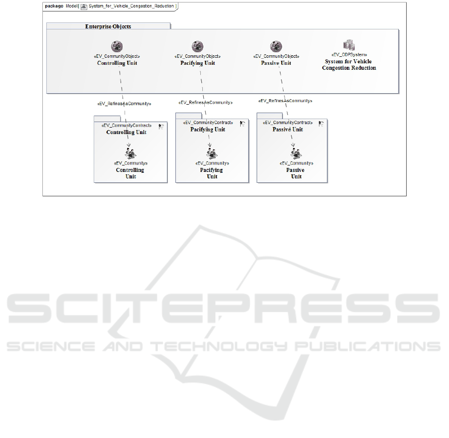
Figure 4: Enterprise specification of the System for Vehicle Congestion Reduction.
Those classes express the community objects that
model the communities as simple objects. The
community objects are included in the package
“Enterprise Objects.” The objects Traffic Agent and
Watchperson are examples of those enterprise objects
that interact with the system.
It is worth pointing out that the roles of the actors
may overlap. For example, the Data Analyst and the
Moderator may take up the role of Driver, Passenger,
and Pedestrian or a Driver may work as Watchperson
or Data Analyst. In fact, an actor may take up another
role at a certain moment to further contribute with the
system’s goal, which is to reduce vehicle congestion
in the city.
5 DISCUSSION OF RESULTS
The actor Sensor (Citizen and Physical) introduced
in the model may allow for greater system efficiency
through the data collected both by physical and hu-
man (VGI) sensors. The communities defined may
take up several roles in the system. They all have a
task in common, i.e., supplying data. It is up to the
system user whether to make a decision or not, such
as whether he or she should follow a certain route or
take another path (if it exists). Figure 5 shows the
roles identified regarding the communities involved.
The roles specified of each community may share a
common goal in the system such as supplying volun-
teered data (VGI).
Three communities were identified that make up
the System for Vehicle Congestion Reduction: Con-
trolling Unit, Pacifying Unit, and Passive Unit. Roles
were attributed to the communities regarding their be-
haviors. As well as a community, the system itself
has its role – to reduce vehicle congestion by provid-
ing information regarding events that hold up the flow
of vehicles through that route. The objects contained
in each of the communities have roles concerning the
activities of their community.
6 CONCLUSIONS AND FUTURE
WORKS
It is concluded that the ICA’s original SDI model pro-
posed by (Hjelmager et al., 2008) and its extension
developed by (Cooper et al., 2011) are solid enough
for the development of an architecture for smart cities.
However, due to the complexity of the domain, two
new specializations had to be included.
The specification of the System for Vehicle Con-
gestion Reduction exemplified how smart solutions
can be developed by combining SDI and VGI. Sen-
sors are key parts in the development of smart cities.
Moreover, this combination allows smart applications
to be developed in several domains of a city, thus al-
lowing for the transformation of a “common” city into
a smart city. This way, a sustainable and efficient en-
vironment can be obtained in which the population
has better quality of life and is less impacted by the
inherent issues of a city (congestion, electric grid or
water distribution grid failure). The authors of this
study have high expectations towards the use of SDI
and VGI in the development of smart cities, which
opens a huge space for new researches and techno-
logical innovations.
SMARTGREENS 2017 - 6th International Conference on Smart Cities and Green ICT Systems
248
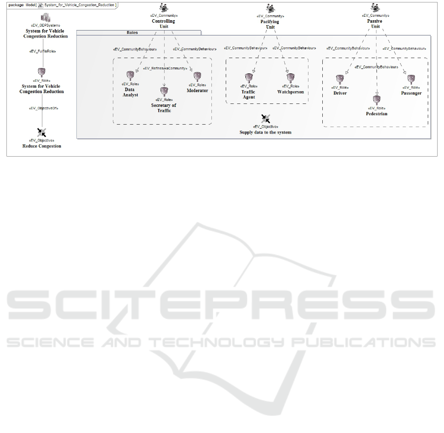
Figure 5: Attribution of community roles.
ACKNOWLEDGEMENTS
Project partially funded by the agencies CAPES,
FAPEMIG and CEMIG.
REFERENCES
B
´
ejar, R., Latre, M.
´
A., Nogueras-Iso, J., Muro-Medrano,
P. R., and Zarazaga-Soria, F. J. (2012). An rm-odp
enterprise view for spatial data infrastructures. Com-
puter Standards & Interfaces, 34(2):263–272.
Caragliu, A., Del Bo, C., and Nijkamp, P. (2011). Smart
cities in europe. Journal of urban technology,
18(2):65–82.
Cooper, A. K. et al. (2011). Extending the formal model
of a spatial data infrastructure to include volunteered
geographical information.
Cooper, A. K. et al. (2013). A spatial data infrastructure
model from the computational viewpoint. Interna-
tional Journal of Geographical Information Science,
27(6):1133–1151.
Da Silva, W. M. et al. (2013). Smart cities software archi-
tectures: a survey. In Proceedings of the 28th Annual
ACM Symposium on Applied Computing, pages 1722–
1727. ACM.
DENATRAN (2010). Manual brasileiro de fiscalizac¸
˜
ao de
tr
ˆ
ansito - compet
ˆ
encia municipal, incluindo as concor-
rentes dos
´
org
˜
aos e entidades estaduais de tr
ˆ
ansito e
rodovi
´
arios. In Manual de orientac¸
˜
ao Aprovado pelo
CONTRAN na Resoluc¸
˜
ao N
o
371, de 10 de dezembro
de 2010, volume 1, page 26.
Fern
´
andez, M. J.,
´
Alvarez, P., L
´
opez, F., and Muro, P.
(2006). Idezar: un ejemplo de implantaci
´
on de una ide
en la administraci
´
on local. Actas de las IX Jornadas
Sobre Tecnolog
´
ıas de la Informaci
´
on para la Modern-
izaci
´
on de las Administraciones P
´
ublicas (Tenimap
2006). Sevilla, Espa
˜
na.
Giffinger, R. et al. (2007). Smart cities: Ranking of euro-
pean medium-sized cities. vienna, austria: Centre of
regional science (srf), vienna university of technology.
Hjelmager, J. et al. (2008). An initial formal model for
spatial data infrastructures. International Journal of
Geographical Information Science, 22(11-12):1295–
1309.
ISO/DIS 37120 (2013). Sustainable development and re-
silience of communities — indicators for city services
and quality of life. INTERNATIONAL ORGANIZA-
TION, 2013:08–27.
Kyriazopoulou, C. (2015). Architectures and requirements
for the development of smart cities: A literature
study. In International Conference on Smart Cities
and Green ICT Systems, pages 75–103. Springer.
Linington, P. F., Milosevic, Z., Tanaka, A., and Vallecillo,
A. (2011). Building enterprise systems with ODP:
an introduction to open distributed processing. CRC
Press.
Oliveira, I. L. and Lisboa Filho, J. (2015). A spatial data
infrastructure review - sorting the actors and policies
from enterprise viewpoint.
Organization, W. H. et al. (2016). World health statistics
2016: monitoring health for the sdgs, sustainable de-
velopment goals.
Percivall, G. et al. (2015). Ogc smart cities spatial informa-
tion framework. OGC White Paper.
P
´
erez-Mart
´
ınez, P. A., Mart
´
ınez-Ballest
´
e, A., and Solanas,
A. (2013). Privacy in smart cities-a case study of smart
public parking. In PECCS, pages 55–59.
P
´
erez P
´
erez, M. et al. (2013). Infraestructuras de datos
espaciales como eje central del desarrollo de las
smart cities. IV JORNADAS IB
´
ERICAS DE INFRA-
ESTRUTURAS DE DADOS ESPACIAIS. Toledo, Es-
panha.
Seto, K. C. et al. (2012). Global forecasts of urban expan-
sion to 2030 and direct impacts on biodiversity and
carbon pools. Proceedings of the National Academy
of Sciences, 109(40):16083–16088.
Su, K., Li, J., and Fu, H. (2011). Smart city and the appli-
cations. In Electronics, Communications and Control
(ICECC), 2011 International Conference on, pages
1028–1031. IEEE.
An Architectural Model for Smart Cities using Collaborative Spatial Data Infrastructures
249
