
Automating Government Spatial Transactions
Premalatha Varadharajulu
1,2
, Geoff West
1,2
and David A. McMeekin
1,2
, Simon Moncrieff
1,2
and Lesley Arnold
1,2
1
Department of Spatial Science, Curtin University, Perth, Western Australia, Australia
2
Cooperative Research Centre for Spatial Information, Perth, Western Australia,
Australia
Keywords: Spatial Transaction, Spatial Data Supply Chain, Artificial Intelligence, Semantic Web, Ontology,
Rule-based Reasoning, OWL-2.
Abstract: The land development approval process between local authorities and government land and planning
departments is manual, time consuming and resource intensive. For example, when new land subdivisions,
new roads and road naming, and administrative boundary changes are requested, approval and changes to
spatial datasets are needed. The land developer submits plans, usually on paper, and a number of employees
use rules, constraints and policies to determine if such plans are acceptable. This paper presents an approach
using Semantic Web and Artificial Intelligence techniques to automate the decision-making process in
Australian jurisdictions. Feedback on the proposed plan is communicated to the land developer in real-time,
thus reducing process handling time for both developer and the government agency. The Web Ontology
Language is used to represent relationships between different entities in the spatial database schema. Rules
on geometry, policy, naming conventions, standards and other aspects are obtained from government policy
documents and subject-matter experts and described using the Semantic Web Rule Language. Then when
the developer submits an application, the software checks the rules against the request for compliance. This
paper describes the proposed approach and presents a case study that deals with new road proposals and
road name approvals.
1 INTRODUCTION
Land developers and local government authorities
are required to submit proposals for new
subdivisions to land and planning departments for
approval. These new subdivisions include new land
parcel boundaries, roads and road names, and
changes to local authority boundaries. The approval
process often spans many work teams and new
information, such as property addresses may need to
be generated. This manual process can be time
consuming and resource intensive.
New methods are required to reduce data
handling and support the automation of transactions
with government. Current workflows are
characterised by several decision points and a trail of
paper documents are often created to formalise the
decision-making process and to provide a reference
point for legal transactions further along the land
administration process (Varadharajulu et al., 2015).
As a result, there is often a time delay of several
weeks during which a new subdivision is considered
by authorities from the various land development
and planning perspectives.
This research seeks to automate the spatial
transaction process using artificial intelligence with
ontologies to create rules that replace the human
decision-making process for land development
approvals. A case study examining new road
proposals, road names and land administration
boundary changes is used to demonstrate the
approach. This research is being conducted in
conjunction with the Western Australian Land
Information Authority (Landgate). Landgate is the
approving authority for all new subdivisions in
Western Australia, and is responsible for land
administration boundary changes resulting from land
development activity.
The Semantic Web was first introduced by Tim
Berners-Lee who imagined it as “a web of data that
can be processed directly and indirectly by
machines” (Berners-Lee and Fischetti, 1999). This
research is inspired by the increased bandwidth of
the Internet and advances in Semantic Web
technologies, which now make it possible to
automate the human elements of the decision-
making process on the Web.
Varadharajulu, P., West, G., McMeekin, D., Moncrieff, S. and Arnold, L.
Automating Government Spatial Transactions.
In Proceedings of the 2nd International Conference on Geographical Information Systems Theory, Applications and Management (GISTAM 2016), pages 157-167
ISBN: 978-989-758-188-5
Copyright
c
2016 by SCITEPRESS – Science and Technology Publications, Lda. All rights reserved
157

Rule-based systems have been used for decision
support in the past but these are typically closed
client bases systems. However the advantage of the
Semantic Web is that the data, ontologies and rules
are described using well defined standards (w3c.org)
and can be made available over the Web as
published resources, typically in one of a number of
machine (and human) readable formats (Gupta and
Knoblock, 2010). The vision is that, ontologies,
especially those of a general nature, can be shared
and re-used in many applications. In our case, it is
envisaged that once a working solution for the
approvals process has been validated for one
jurisdiction (Western Australia), the ontologies and
rules can be used in other jurisdictions (Victoria,
New South Wales etc.) and domains.
The work is part of a research program into
Spatial Data Infrastructures being conducted at the
Cooperative Research Centre for Spatial Information
(CRCSI), Australia. One of the objectives of the
research program is to automate spatial data supply
chains from end-to-end to enable access to the right
data, at the right time, at the right price (McMeekin
and West, 2012).
This research is focusing on the first stage in the
spatial data supply chain process, which is the
creation of spatial data generated through a land
development business process. Instead of paper-
based systems, the method enables the capture of
spatial information in machine-readable form at its
inception point. This is a significant step towards
achieving downstream workflow automation. It also
supports the recording of data provenance in
machine-readable form at the commencement of a
spatial transaction to support legal and data quality
attribution.
The development consists of two stages. In the
first stage, a GUI-based interactive system called
Protégé is used to design ontologies and rules from
spatial data schema and various documents
including policies. The second stage uses a runtime
environment (Jena and Java) to process the
ontologies and rules along with existing and
proposed road data to determine compliance with
policies etc.
2 BACKGROUND AND RELATED
RESEARCH
Methods for spatial data processing and integration
have been researched and developed over the past
few years, however little work has considered the
automation of the decision-making process where
spatial data is an input to the approval process.
One of the objectives of the Semantic Web is to
evolve into a universal medium for information, data
and knowledge exchange, rather than just being a
source for information. To attain this, it uses the well
known http protocol and technologies (Shadbolt et al.,
2006) (Millard, 2010), such as URIs (Universal
Resource Identifiers), RDF (Resource Description
Framework) and ontologies with reasoning and rules.
One of the most important components is the
RDF, which is a language for representing
information about resources on the Web
(http://www.w3.org/RDF/). RDF aims to organize
information in a machine-readable format by
representing information as triples: <subject,
predicate, object>, a concept from the artificial
intelligence community. RDF was originally
considered as metadata but now covers data as well.
RDF triples can be used to represent tables, graphs,
trees, ontologies and rules because it describes the
relationship between subject and object resources
where a ‘object in the <subject, predicate, object>
triple can be another subject enabling subjects to be
linked together. Each of the triple components can
also be a URI so information can be linked across
the Web. RDF formatted data is much easier to
process, because its generic format contains
information that is clearly understandable as a
distributed model.
Reasoning and rules are an important part of this
research and in the Semantic Web, the Ontology
Web Language (OWL-2), based on RDF, is used for
defining Web ontologies that include rules, axioms
and constraints allowing inferencing (discovery of
new knowledge) to be performed.
The Semantic Web has been used for queries by
a user for natural events using observation sensor
data (Devaraju et al., 2015) (Yu and Liu, 2013). In
particular Devaraju et al (2015) describe a number
of ontologies used to model various sensors and
rules used to map queries such as flooding in an area
to the need to sample a number of point water
sensors. Methods have been proposed that have
potential to automate land development approval
processes. For example, the Sensing Geographic
Occurrences Ontology (SEGO) model supports
inferences of institutionalized events (Reitsma,
2005) based on time. However they do not resolve
any conflicts arising if an event qualifies based on
both policy and business rules. This research does
not cover the sensor-specific technical details
(Reitsma, 2005), but instead concentrates on the
business knowledge rules.
GISTAM 2016 - 2nd International Conference on Geographical Information Systems Theory, Applications and Management
158

A large number of open source and proprietary
tools are available for semantic web research and
development. This research uses the Protégé
framework (
http://
protege.stanford.edu/
)
to develop
ontologies and rules because its GUI environment
allows fast design, interactive navigation of the
relationships in OWL ontologies and visualization. It
allows some rule-based analysis to be performed and
can read and write RDF-based files in a number of
different formats. Rules are defined in the form of
ontological vocabularies using SWRL. Like many
other rule languages, a SWRL rule has the form of a
link between antecedent and consequent. The
antecedent refers to the body of the rule, consisting
or one or more conditions, and the consequent refers
to its head, typically one condition. Whenever the
conditions specified in the antecedent are satisfied,
those specified in the consequent must also be
satisfied (O’Connor et al., 2005). Once ontologies
and rules have been defined, they can be imported
into the Apache Jena framework complete with the
Pellet reasoner
(http://clarkparsia.com/pellet/)
to
support OWL for runtime querying and analysis
(Segaran et al., 2009). Combining both Jena and
OWL API libraries, Pellet infers logical
consequences from a set of asserted facts or axioms.
3 CASE STUDY
Landgate administers all official naming actions for
Western Australia under the authority of the
Minister for Lands. The relevant local government
authority generally submits all naming proposals for
ratification by Landgate. All new proposals must
satisfy government policies and standards. The
current process has an online submission form, but
for the most part the process is paper-based and
requires significant human involvement. Current
methods often require negotiation between the
parties involved (i.e. local government and
Landgate). While there are specific rules applying to
new road name approvals, there are grey areas
within policy that are often challenged and can only
be resolved by an experienced negotiator. A request
for a new road name may be transferred back-and-
forth until an outcome is achieved that is satisfactory
to both parties. Outcomes may be different
depending on the expertise of the
negotiator/approver.
Automation is needed to reduce the manual
overhead by extracting expert knowledge for road
name approvals to create a standard set of rules. The
notion is to create a self-service online mechanism
for developers to submit new road names for
approval, underpinned by a complex rule-base and
querying process. Complexity comes from the flow
on effect of such changes. A new land development
results in a change to the surrounding road network.
This has a flow on impact to property street
addressing and an administrative boundary change.
The case study uses the Landgate geographic
road names database, called GEONOMA, to process
the road name proposal. The current online
submission process has the following issues that
complicate the approval process:
• The online form is only used to test whether new
road names are allowable based on a set of road
names that have been reserved for use. If a
proposed name is a reserved road name then the
request will fail. There is no opportunity to
contest the decision.
• A maximum of ten names per application is
allowed; meaning separate applications are required
for larger subdivisions. It is not possible to conduct
cross-reference checks against other submissions
and therefore the process is open to error.
• The current system does not consider the spatial
extent of roads. Figure 1 shows a schematic
submitted for road name approvals that does not
represent the actual proposed location of roads.
Roads do not actually meet up; they are stylized
with solid and dashed lines with arrows etc.
Manual editing and digitising is therefore
necessary to extract the full topology of the
proposed road network complete with
coordinates of junctions.
• The current system does not permit checks on
phonetics and this is an issue for similar
Figure 1: Hardcopy road network plan with road name
application.
Automating Government Spatial Transactions
159

sounding names (e.g., Bailey, Baylee, Bayley,
Baylea). Similar or ‘like’ names (e.g. Whyte and
White) are not allowable under policy guidelines
as they can cause confusion for applications such
as emergency services dispatch. Similarly, the
same road name or a similar sounding road name
is not permitted within close proximity.
• Where an extension to an existing road occurs or
where a road ‘type’ (e.g. cul-de-sac, highway)
changes, the current system is unable to return an
extension to a road name or change to road
suffix, respectively
4 APPROACH
Figure 2 shows the different phases in the land
transaction process from knowledge acquisition to
final feedback. Data is extracted from the various
databases in formats such as html, json, csv and xml
and converted to RDF. Ontologies in OWL are
created from database schema and models in the
interactive GUI based Protégé environment. Rules
are generated in SWRL by an expert. Once the
system has been developed, the data, ontologies and
rules can be used in the runtime environment Jena
with a rule engine by a developer to process road
changes.
4.1 Knowledge Acquisition
Knowledge acquisition was used to extract, structure
and organise knowledge from policy documents,
data dictionaries and by interviewing subject matter
experts. This knowledge was then used to create the
road naming rules. The knowledge acquisition
process used the following sources:
Figure 2: Data integration/reasoning architecture.
GISTAM 2016 - 2nd International Conference on Geographical Information Systems Theory, Applications and Management
160

1 Rules sourced from policy standards:
• A road name cannot be used if it already
exists within a 10km radius of the new road
in city areas or 50km in rural areas
• A road name may not be used more than 15
times in the State of Western Australia
2 Rules sourced by interviewing subject matter
experts:
• A name must not relate to a commercial
business trading name or non-profit
organisation
• A name must not sound like an existing name
• A name with the suffix type ‘place’ or ‘close’
cannot be assigned to a road greater than a
specified length (200m)
• A historical name, such as ANZAC, cannot
be used
• A name with road type ‘rise’ can only be
used for roads that have elevation or are at an
incline
• Abbreviated names derived from the suburb
name are not acceptable for new road names
3 Rules sourced by accessing data dictionaries:
• Discriminatory or derogatory names are not
allowed
• A name in an original Australian Indigenous
language will be considered for a new road
name with reference to its origin
With the current traditional naming process,
satisfying the rules identified above is time
consuming because of the back-and forth process
between developer and approver. As an example,
from a process perspective, when a land developer
or local authority requests a new road name within a
development site, a spatial validation process is run
to test whether the proposed name:
• is already in use in the local authority and if so,
whether it is within 10km of the new site; and
• has already been used 15 times across the State.
In addition to policy rules, subject matter experts
use broader contextual knowledge when determining
if a new road name is valid. For example, during the
approval process experts check the scope for the
proposed subdivision within the wider development
site to avoid subsequent changes resulting from
incorrect initial decisions.
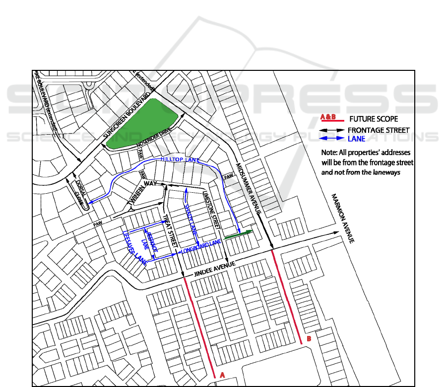
Figure 3 presents a further example of where
expert knowledge in the road naming process, from
initial application to final approval, is required.
During the negotiation phase with the land
developer, documents are transferred back and forth
between both parties; each making changes to a
paper plan by way of communication. The following
notes, written by Landgate to the developer,
illustrate typical negotiations (See Figure 3):
• Jindee Avenue: The road type is suitable,
however the name Jindee is not. Apart from
sounding similar to the suburb name, this is also
an abbreviated name derived from the suburb
name and is not acceptable. A replacement name
is required.
• Limestone Street and Twinfin Way: The street is
continuous so one street name can be used for
this street.
• Noserider Drive: The name is suitable, however
the road type Drive is not (as this road is adjacent
below in this case) to a future open space then
relevant types are Way, Vista, View, or if it
shaped like a crescent, then Crescent can be
used).
• Longboard Lane: The name complies with
policy, however it is too long a word for that
road. Also a portion of the extent is a part of
Hilltop Lane (mentioned in green). A short name
with its origin is required. Alternatively, the
developer can hold the name Longboard for
future use when a long road name is needed in
the vicinity.
• Lifesaver Lane: the name is suitable, however it
appears that there will be a third entry off
Twinfin Court. Clarification of this will be
necessary and an additional name for a portion
(i.e. the northern east/west portion) will be
needed.
• Midsummer Avenue and Treat Street: extensions
are suitable because there are possibilities for the
future development. The roads on the south side
of Jindee Avenue (A & B) are currently unnamed
as they are part of a later development stage.
4.2 Ontology Development
Once the rules behind both policy standards and
business processes are understood, the next step is to
generate the ontology model from multiple sources
of information. This ontology is developed as a
global schema that means that while it works with
the Landgate GEONOMA database, it can also be
used in conjunction with other databases that link
the spatial extent of a road to the road naming
process. Figure 4 presents an overview of the
generated Geo_feature ontology containing classes,
data and object properties, and instances. Links
show relationships such as domain, range and
subClassOf. The ontological components are
summarised below.
Automating Government Spatial Transactions
161
4.2.1 Geo_feature Ontology
The GEONOMA dataset is exported to XML and
then imported into Protégé to help with the ontology
generation process. Protégé was chosen as it is an
open source tool with wide community support that
supports ontology development and reasoning, and
importantly OWL DL, W3C description logic
standard. The Geo_feature ontology consists of
OWL classes, data and object properties, and
individuals and is expressed in the form of OWL-2.
Each OWL class is associated with a set of
individuals. Object properties link individuals of one
class to other class individuals. Data properties link
one individual to its data values. Value constraints
and cardinality constraints are used to restrict the
attributes of the individual. For example each
ROAD instance much have only one ROAD_TYPE
through an object property link. Figure 5 shows the
relationships between class instances. An example
for a ROAD_TYPE instance is shown at bottom
right. It has property restrictions handled by
cardinality constraints. Each instance must have
information about its type, description and whether
it is a cul-de-sac or an open ended road type.
Typically, further work is required to create the full
semantics in the ontology. All semantic relationships
(links) between data components are needed because
mapping from datasets directly is not adequate to
explain the full model (Ghawi and Cullot, 2009). For
example, every instance of ROAD, LGA and
LOCALITY has a link with an instance of
GEONOMA. Similarly every ROAD has a link with
LGA and LOCALITY. These are inferred in Protégé
by invoking the OWL-DL rule reasoner.
4.2.2 Ontological Classifications and Spatial
Relations
The resulting Geo_feature ontology represents the
spatial relationship between several datasets
including the road network, local government
authority boundaries, locality and language. These
datasets combined are used in the road name
approval process and checked for constraints. The
spatial relationship distinction is mainly based on
source datasets. However,
from a realistic
viewpoint, these source datasets can only supply
Figure 3: Road Naming process in Jindalee-City of Wanneroo Western Australia.
GISTAM 2016 - 2nd International Conference on Geographical Information Systems Theory, Applications and Management
162
Figure 4: An overview of Geo_feature ontology.
Figure 5: OntoGraf representation for classes and instances.
Automating Government Spatial Transactions
163
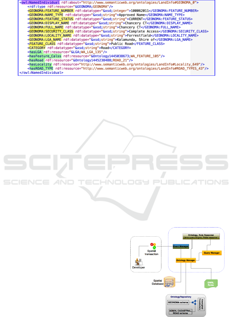
Figure 6: Source data in RDF format.
certain details relating to a feature name. To make it
more meaningful there is a need to add additional
vocabularies such as the Australian indigenous
language dictionary and the WordNet ontology. By
adding these we can check the meaning of a name
and whether or not it complies with the chosen road-
naming theme. To process a road request the road
structure needs to be examined. By adding road
coordinates it is possible to check where the
proposed road will be actually developed.
4.3 Rule Development
Figures 4 and 5 shows several relations between
spatial datasets, such as the link between road and
locality. Many of these relationships are inferred by
the rule-based mechanism automatically from
constraints, axioms and links defined in the
ontology, thereby reducing the need for manual
specification for all instances. The Pellet reasoner is
used to infer decisions from these rules in Protégé.
More complex, nested conditions can be handled by
Boolean operators in SWRL rules are executed with
the rule engine (Powell, 2014).
4.4 Data Formatting/Conversion
Once the ontology and rules have been developed
the next stage is to access the source datasets to
reason with the ontologies. To make this happen it is
necessary to convert the source dataset into RDF
triple format. In this way all data are accessible in
one common format and ready for initial reasoning
(Broekstra et al., 2002). There are many data
conversion and integration tools (Karma, MASTRO,
OpenRefine and TripleGeo) that can be used for this
conversion. MASTRO has been
shown to be a
successful Ontology-Based Data Access (OBDA)
system through a series of demonstrations
(Calvanese et al., 2011, Poggi et al., 2008, Savo et
al., 2010, Rodriguez-Muro et al., 2008, Zhang et al.,
2013). It can be accessed by means of a Protégé
plugin. The facilities offered by Protégé can be used
for ontology editing, and functionalities provided by
the MASTRO plugin can be used to access external
data sources. Openrefine (http://openrefine.org/) is
used to convert data to RDF format. Spatial
information from a shape file can converted into
RDF triples (Patroumpas et al., 2014)
(https://github.com/GeoKnow/TripleGeo). Figure 6
shows an RDF instance. Having the data instances in
RDF format, Apache Jena, with the help of MAVEN
repositories is used to link all the ontologies,
instances and rules at runtime.
5 PROCESS/OPERATION
5.1 System Implementation
Figure 7 shows the runtime system architecture,
Figure 7: System architecture.
GISTAM 2016 - 2nd International Conference on Geographical Information Systems Theory, Applications and Management
164

Table 1: SWRL rules with the action of each of the rules.
Purpose
SWRL rules
R1
Relate a road link with existing
road either directly or thru
another proposed road
Road(?R1), Road(?Old), hasRoadLink(?R1, ? Old), status(?R1, "New"),
status(?Old, "Existing"), notEqual(?R1, ?R2) -> isAllowed(?R1, true)
Road(?R1), Road(?R2), Road(?Old), hasRoadLink(?R1, ? R2),
hasRoadLink(?R2, Old), notEqual(?R1, ?R2), notEqual(?Old, ?R2),
status(?Old, "Existing"), status(?R1, "New"), status(?R2, "Aproved"), ->
R2 Check the road length to
against road types
RType(?T1), Road(?R1), Road_Type(?R1, ?T1), hasLength(?R1, ?$200$),
SameAs (?T1, ?$Close$) -> isAllowed(?R1, true)
R3 Check the road access against
road type
Road(?R1), hasRoadUse(?R1, “Openended”), Road(?Old1), Road(?Old2),
hasRoadLinkS(?R1, ?Old1), hasRoadLinkE(?R1, ?Old2), status(?R1,
"New"), status(?Old1, "Existing"), status(?Old2, "Existing"),
notE
q
ual
(
?R1
,
?Old1
),
-> isAllowed
(
?R1
,
true
)
R4 Check the road usage against
road link.
Road(?R1), hasRoadUse(?R1, “ cul-de-sac”), Road(?Old1), Road(?Old2),
hasRoadLinkS(?R1, ?Old1), hasRoadLinkE(?R1, ?Old2), status(?R1,
"New"), status(?Old1, "Existing"), status(?Old2, "Existing"),
notEqual(?R1, ?Old1), -> isAllowed(?R1, false)
R5 Check the roadway with view
RType(?T1), Road(?R1), Road_Type(?R1, ?T1), SameAs (?T1, ?$Vista$)
-> isAllowed(?R1, true)
R6 Check the road name with
definite article
Road(?R1), containsIgnoreCase(?R1, "The") -> isAllowed(?R1, false)
which has been implemented using Jena in Java. The
ontology repository consists of multiple ontologies
derived from the data schema, data individuals, and
rules, as well as non-specific ontologies such as
Aboriginal vocabularies. The event manager collects
the land transaction information and supports the
ontology manager to infer the information relevant
to that application. For example, if the application
relates to a new subdivision, then it will gather the
details spatially related to that land area, or if the
proposed road name relates to a road name change,
then it will gather information related to
naming
from the policy. The Ontology Manager collates the
land information from the spatial database into the
knowledge base.
5.2 Reasoning
The initial stage of reasoning is carried out in Jena
with the Pellet OWL reasoner that checks the logical
consistency of the model, processes the individuals
(current, approved and proposed roads), infers new
information including links and relationships, and
updates the model with the inferred information.
Through consistency checking, the system confirms
whether or not any contradictory facts appear within
the ontology. For example, the domain and range
constraints on the feature relation: GEONOMA
Features: Feature_Class. Constraints on the relation
mean that GEONOMA has features, which come
under only one of the Feature_Class categories. The
reasoner will throw relevant errors if any ontological
inconsistency appears given the proposed roads, for
example if an instance of GEONOMA is linked to
an instance of a ROAD and missing any property
restriction relations.
Similarly, assigning an individual to two
disjointed categories such as LGA and Locality will
make the ontology inconsistent. Consider the case
where every GEONOMA instance is represented
with the ROAD feature type; it must have at least
two coordinates and link to other road instances.
This is declared as a necessary and mandatory
condition for instances of the ROAD category in the
OWL class description. When an individual in OWL
satisfies such a condition then the reasoner
automatically deduces that the individual is an
instance of the specified category.
As well as the reasoning described above, to
gather more information additional reasoning is
required. Rules are expressed in terms of ontological
vocabularies using SWRL. Table 1 shows some
examples of implemented rules. As mentioned
earlier, in each rule, the antecedent refers the body
of the rule and the consequent refers to the head. The
head and body consist of a conjunction of one or
more atoms. Atoms are stated in the form of C(?R)
P(?R,?X), where C and P represent an OWL
description and property, respectively. Variables
representing the individuals are in the form, for
Automating Government Spatial Transactions
165

example ?R, where the variable R is prefixed with a
question mark. Table 1 shows some examples of
rules related to the application.
• Rule R1 automatically infers information with
the help of a road link between proposed and
existing roads from the source dataset with
reference to road coordinates and feature id. This
rule is necessary as every road needs to link with
at least one other road to allow access.
• Rule R2 checks road length against road type.
Checking the road length for shortest road types
(‘Place’, ‘Close’ and ‘Lane’) is necessary to
avoid confusion with the preference for road
usage.
• Rules R3 and R4 check the compatibility
between road usage and road links. For example
an open-ended road must have a road link at both
start and end points of the road.
• Rule R5 checks whether or not the proposed road
has a wide panoramic view across surrounding
areas.
• Rule R6 prevents the definite article (‘The’)
being used in the road name.
6 CONCLUSIONS
This paper proposes a Semantic Web solution for
automating the decision making process for spatially
related transactions. Examples of such transactions
are approvals for new roads and road names. The
method develops a Geo_feature ontology, which
comprises knowledge of roads and constraints,
axioms and rules extracted from sources such as
experts, policy, geometry and past decision
documents. The method shows how ontologies are
manipulated with reasoning techniques to infer new
information.
Semantic Web techniques are used as the
solution because it allows the ontologies and rules to
be published in RDF and made available for other
application domains. For example, similar
processing is envisaged for points of interest
(bridges, parks), and the reconciliation of addresses.
This method has proven successful for the
process that involves simple spatial queries, such as
a request for road name approval. More rules and
relationships with existing ontology elements are
being developed as further examinations are carried
out into the datasets and business rules. Future work
is also examining reasoning over other information
that can be used to aid the approval process. For
example an approver may use aerial photography to
check for the presence of vegetation, as the removal
of trees may need approval, and digital elevation
maps used to determine if the proposed roads are
viable.
ACKNOWLEDGEMENTS
The work has been supported by the Cooperative
Research Centre for Spatial Information, whose
activities are funded by the Australian
Commonwealth's Cooperative Research Centres
Programme. The authors extend their thanks to
Landgate for providing the example datasets for the
case study and subject matter experts for rule
formulation.
REFERENCES
Berners-Lee, T. & Fisch (Placeholder1)Etti, M. 1999.
Weaving The Web: The Original Design And Ultimate
Destiny Of The World Wide Web By Its Inventor
.[San Francisco]: Harpersanfrancisco.
Broekstra, J., Kampman, A. & Van Harmelen, F. 2002.
Sesame: A Generic Architecture For Storing And
Querying Rdf And Rdf Schema. The Semantic Web—
Iswc 2002. Springer.
Calvanese, D., De Giacomo, G., Lembo, D., Lenzerini,
M., Poggi, A., Rodriguez-Muro, M., Rosati, R., Ruzzi,
M. & Savo, D. F. 2011. The Mastro System For
Ontology-Based Data Access. Semantic Web, 2, 43-53.
Devaraju, A., Kuhn, W. & Renschler, C. S. 2015. A
Formal Model To Infer Geographic Events From
Sensor Observations. International Journal Of
Geographical Information Science, 29, 1-27.
Ghawi, R. & Cullot, N. Building Ontologies From
Multiple Information Sources. 15th Conference On
Information And Software Technologies
(It2009)(Kaunas, Lithuania, 2009.
Gupta, S. & Knoblock, C. A. A Framework For
Integrating And Reasoning About Geospatial Data.
Extended Abstracts Of The Sixth International
Conference On Geographic Information Science
(Giscience), 2010.
Mcmeekin, D. A. & West, G. 2012. Spatial Data
Infrastructures And The Semantic Web Of Spatial
Things In Australia Research Opportunities In Sdi
And The Semantic Web. 2012 5th International
Conference On Human System Interactions (Hsi
2012), 197-201.
Millard, E. 2010. The Semantic Web Could Enable Even
Greater Access To Information. Promise Of A Better
Internet, Teradata Magazine Online.
O’connor, M., Knublauch, H., Tu, S., Grosof, B., Dean,
M., Grosso, W. & Musen, M. 2005. Supporting Rule
GISTAM 2016 - 2nd International Conference on Geographical Information Systems Theory, Applications and Management
166

System Interoperability On The Semantic Web With
Swrl. The Semantic Web–Iswc 2005. Springer.
Patroumpas, K., Alexakis, M., Giannopoulos, G. &
Athanasiou, S. Triplegeo: An Etl Tool For
Transforming Geospatial Data Into Rdf Triples.
Edbt/Icdt Workshops, 2014. 275-278.
Poggi, A., Rodriguez, M. & Ruzzi, M. Ontology-Based
Database Access With Dig-Mastro And The Obda
Plugin For Protégé. Proc. Of Owled, 2008.
Powell, J. 2014. Librarian's Guide To Graphs, Data And
The Semantic Web, Chandos Publishing (Oxfor.
Reitsma, F. E. 2005. A New Geographic Process Data
Model.
Rodriguez-Muro, M., Lubyte, L. & Calvanese, D.
Realizing Ontology Based Data Access: A Plug-In For
Protégé. Data Engineering Workshop, 2008. Icdew
2008. Ieee 24th International Conference On, 2008.
Ieee, 286-289.
Savo, D. F., Lembo, D., Lenzerini, M., Poggi, A.,
Rodriguez-Muro, M., Romagnoli, V., Ruzzi, M. &
Stella, G. 2010. Mastro At Work: Experiences On
Ontology-Based Data Access. Proc. Of Dl, 573, 20-
31.
Segaran, T., Evans, C. & Taylor, J. 2009. Programming
The Semantic Web, " O'reilly Media, Inc.".
Shadbolt, N., Hall, W. & Berners-Lee, T. 2006. The
Semantic Web Revisited. Intelligent Systems, Ieee, 21,
96-101.
Varadharajulu, P., Saqiq, M. A., Yu, F., Mcmeekin, D. A.,
West, G., Arnold, L. & Moncrieff, S. 2015. Spatial
Data Supply Chains. International Archives Of The
Photogrammetry, Remote Sensing & Spatial
Information Sciences, 40.
Yu, L. & Liu, Y. 2013. Using Linked Data In A
Heterogeneous Sensor Web: Challenges, Experiments
And Lessons Learned. International Journal Of
Digital Earth, 1-21.
Zhang, Y., Chiang, Y.-Y., Szekely, P. & Knoblock, C. A.
A Semantic Approach To Retrieving, Linking, And
Integrating Heterogeneous Geospatial Data. Joint
Proceedings Of The Workshop On Ai Problems And
Approaches For Intelligent Environments And
Workshop On Semantic Cities, 2013. Acm, 31-37.
Automating Government Spatial Transactions
167
