
Using Wearables for Travel Assistance
Christian Samsel, Igor Dudschenko, Wolfgang Kluth and Karl-Heinz Krempels
Information Systems, RWTH Aachen University, Aachen, Germany
Keywords:
Assistance, Travel Information, Navigation, Ubiqitous Computing, Wearables.
Abstract:
In the last decade, personal mobility has become more diverse and more complex. Public transportation net-
works have grown bigger and new travel modes, e.g., car sharing, have emerged. Thus the required electronic
travel assistance, usually provided by smartphone applications, has been well-established and is generally ac-
cepted. Unfortunately using a smartphone application to check the itinerary while travelling can be a hassle.
The traveller has to pull out the device, unlock it, start the application and find the required information inside
the application. In the meantime he or she is distracted which causes a loose of time and also may lead to
dangerous situations, e.g., in traffic. To improve this situation we developed a smartwatch application follow-
ing the Cascading Information Theory principle which assists the traveller by displaying all journey-related
required information on his or her wrist and notifies him or her when necessary. The prototype of the applica-
tion was evaluated in an initial user test (n = 5) and improvement compared to a single smartphone application
was assessed. The evaluation results showed that users prefer a smartwatch/smartphone based solution over a
pure smartphone application and are distracted for a shorter timespan.
1 INTRODUCTION
Shifts in technology usage and globals trends, e.g.,
urbanization, change peoples mobility. Growing pub-
lic transportation networks and new transport modali-
ties, e.g., car sharing, give travelers more options and
therefore, make traveling more complex. Simplify-
ing the usage of such complex mobility services by
assisting the traveler can potentially improve the ac-
ceptance and therefore lower emissions (Chapman,
2007) (Camacho et al., 2012). A lot of applications
and projects, both stationary and smartphone based
have been established for mobility services around
the world and for various platforms (see Section 2).
Most of these applications focus on the preparation
of the trip. Traveler can compare different prices, de-
parture times and itineraries and commonly also book
the respective services. Although the planning of a
trip might be complex itself, it is usually conducted
in advance of the actual trip and the traveler is not
on any sort of pressure (he or she has enough time
and is in a familiar environment). In contrast, un-
dertaking a trip usually involves a lot of stress, es-
pecially when multiple mobility services, e.g., con-
necting trains or planes, are involved. Traveler are in
distracting and confusing environments, like train sta-
tions, have to carry luggage etc and meanwhile have
to check for, e.g., departure information, therefore
Travel Assistance applications are required. Travel
assistance applications allow a quick information ac-
cess to itinerary information and guide the traveler to
his or her destination.
Most current travel-related smartphone applica-
tion present a great amount of information (some of it
usually redundant and unnecessary) and have an ap-
pealing GUI. These applications usually perform well
in lab scenarios but lack usability in the real world.
To mitigate these issues the Cascading Information
Principle has been applied to mobile travel informa-
tion (Samsel et al., 2014) and proven feasible (Beul-
Leusmann et al., 2014). The Cascading Information
Principle suggests “to unveil information about the
game in as small amounts as possible to ensure the
user’s focus exactly on the desired objective. Thereby,
confusion and misdirection of players by providing
excess information is prevented and each iteration of
new data can be applied directly.”
1
Although, initially
developed in a game context, the concept also applies
to real world scenarios.
Wearables are smart devices which are usually
worn as garments or accessories. Current examples
are watches, bracelets, glasses, shirts and shoes. Al-
though very different in nature, all wearables have
1
http://techcrunch.com/2010/08/25/scvngr-game-
mechanics/
635
Samsel C., Dudschenko I., Kluth W. and Krempels K..
Using Wearables for Travel Assistance.
DOI: 10.5220/0005481306350641
In Proceedings of the 11th International Conference on Web Information Systems and Technologies (WEBIST-2015), pages 635-641
ISBN: 978-989-758-106-9
Copyright
c
2015 SCITEPRESS (Science and Technology Publications, Lda.)

some common characteristics; They have low pro-
cessing power, none or very few input and output
methods like buttons or a display. Because of these
properties wearables are usually used as an extension
to an existing device, e.g., a smartphone. They allow
a quick information access or a simple interaction via
a single button press. It’s easier and faster to check
ones (smart) watch by turning the wrist, compared to
check the smartphone by pulling it out of a pocket /
purse, unlock it and maybe even start the respective
app.
Thus, we realized a wearable-based travel assis-
tance application, following the cascading informa-
tion principle and evaluated the application in a real
world field test.
The remainder of this paper is structured as fol-
lows: In Section 2, related research and existing ap-
plications are discussed. Section 3 derives our ap-
proach by listing requirements to the system, whereas
Section 4 presents the working prototype implemen-
tation. The evaluation methodology and results are
presented in Section 5 followed by Section 6 conclud-
ing the paper.
2 RELATED WORK
This Section gives a brief overview on related scien-
tific work and existing applications.
Multiple approaches for pedestrians navigation
have been introduced. (Baus et al., 2002) established
a pedestrian navigation system with a hybrid solution
titled Project REAL, already predicting the evolution
of personal navigation systems (“Personal navigation
systems that extend beyond today’s use in cars will
play a major role in the future.”). The system is capa-
ble of automatically adapting to location changes and
presenting directions to the traveler on a variety of dif-
ferent devices. (Wenig et al., 2014) discuss different
approaches of combining maps and panoramic pho-
tographs for pedestrian navigation. They acknowl-
edge the problem of distraction by pointing out an in-
cident where a test participant disregarded a red traffic
light while using the navigation system. (May et al.,
2003) suggest a landmark based approach, which rely
on orientation points like buildings as navigations
cues instead of distances or street names. (Chowaw-
Liebman et al., 2010; Heiniz et al., 2012) transfers
this idea to a turn-by-turn approach to manage navi-
gation inside large, complicated buildings using land-
mark representations for orientation rather than street
names. A different approach for navigation assis-
tance for pedestrians and public transport is Pulsemap
(Zargamy et al., 2013), which rely on the results in
Figure 1: The Qixxit android application in travel compan-
ion mode (only available in German).
(Pascoe et al., 2000). Pascoe et al. state that travelers
are distracted by audio and visual clues, which po-
tentially lead to dangerous situations. Zargamy et al.
approached this by using the vibrations of a wearables
device. Different vibrations lengths convey different
directions, e.g., 100ms denote “turn left”, whereas
200ms denote “turn right”.
Wearables, although a new technology, have been
deployed to various fields of assistance applications,
most notably to e-Health systems. (Jonas et al., 2014)
introduced wearable technology to assist nurses in
clinical care, whereas (Sun et al., 2014) present a
wearable platform aimed towards patients. In (Jiang
et al., 2014) the authors present a wearable glove for
service and maintenance personnel.
Qixxit
2
is the newest travel information platform
provided by Deutsche Bahn. It incorporates a travel
companion (travel assistance) mode presented in Fig-
ure 1. It displays the time until the departure of the
next connection, the respective train number and plat-
form number, loosely following the Cascading Infor-
mation principle.
3 APPROACH
This Section documents step-by-step the conceptual
development of the approach. Our approach is based
on the travel assistance concept introduced in (Samsel
et al., 2014). In this work only the Wearables related
extension is described.
2
http://www.qixxit.de
WEBIST2015-11thInternationalConferenceonWebInformationSystemsandTechnologies
636

3.1 Requirements
Before extending an existing information system with
a wearable device, the developer has to decide which
function the wearable device has to fulfill and which
functional or non-functional requirements have to be
met. Based on these factors a suitable device can be
selected. Key requirements are wearability, interac-
tivity, security, communication, battery runtime and
real-time processing (Lymberis, 2005; Meng et al.,
2011; Wei, 2014).
Wearability (R1) is the comfort of carrying a smart
device. The device should not obstruct the move-
ment of the user nor should the users appearance
been altered in a negative way. Ideally, neither
the user nor his or her surroundings should realize
that he or she is wearing a device. This require-
ment is important for travelers, as unobstructed
movement and discreetness are must-haves.
Interactivity (R2) is the ability of the system to offer
services to the user. This typically involves some
kind of input and output using, e.g., key presses,
a display and such. For an assistant application
conveying information to the user is required. Be-
cause of the distraction by the environment inter-
action should be possible with minimal cognitive
effort, so the device should offer a simple and in-
tuitive interface.
Security (R3) in context of wearables essentially
means the device and its communication channel
are protected from unauthorized access. As this
work is only a prototype, security is not a concern.
Communication (R4) is a strong requirement for
most wearable devices as these are mostly a part
of a bigger system. The communication is nowa-
days usually realized as wireless technologies
such as Wi-Fi or Bluetooth for short range com-
munications with other devices of the user or long
range communication like UMTS/LTE for a direct
connection to the internet. As an assistant appli-
cation running on a wearable device will typically
be used in conjunction with smartphone, a short
range communication technology is sufficient.
Battery runtime (R5) is a critical factor for travel
related applications as a power supply is gener-
ally not available while traveling. With recent ad-
vances in battery technology, energy harvesting
and power saving (Gorlatova et al., 2013) we can
assume that current wearable devices are able to
support most trips runtime-wise, especially in ur-
ban scenarios.
Applying the stated requirements to the available de-
vice classes listed in Section 1 the optimal device
Figure 2: Paper prototype for for pedestrian-navigation and
public transport navigation.
is found rather easily. R1 prevent smart glasses as
these heavily interfere with the appearance of the trav-
eler. R2 exclude simple wearables devices like e-
textiles (shirts, shoes etc) or accessories (bracelets
etc) as these usually don’t have any way of interac-
tion. The only remaining class is the smart watch.
Smart watches are unobtrusive to wear but still have
enough interaction and communication capabilities to
fulfill assistance related functions.
For this work, the Sony SmartWatch 2
3
was cho-
sen as platform as it appeared to have the best de-
velopment environment in terms of functionality and
API stability at that time.
3.2 Graphical User Interface
Based on the required information for travel assis-
tance which have been derived in (Samsel et al., 2014)
a paper prototype for the smart watch has been cre-
ated. For pedestrian navigation information about di-
rection, distance and street name are required. For
public transport assistance information about depar-
ture and arrival station, vehicle information and de-
parture and arrival times are required. Figure 2
shows the corresponding view for pedestrian and pub-
lic transport.
4 IMPLEMENTATION
This Section demonstrates the actual prototype appli-
cation.
The prototype was developed using Android Stu-
dio
4
and the Sony Add-On SDK
5
. It consists of
two components with different functions; The smart-
phone component (shown in Figure 3) is responsi-
ble for the communication with the backend (using
Wi-Fi/UMTS) and the user input. Its map view also
serves a fall back for the navigation. The smartwatch
3
http://www.sonymobile.com/de/products/accessories/
smartwatch-2-sw2/
4
https://developer.android.com/sdk/
5
http://developer.sonymobile.com/knowledge-base/
sony-add-on-sdk/
UsingWearablesforTravelAssistance
637
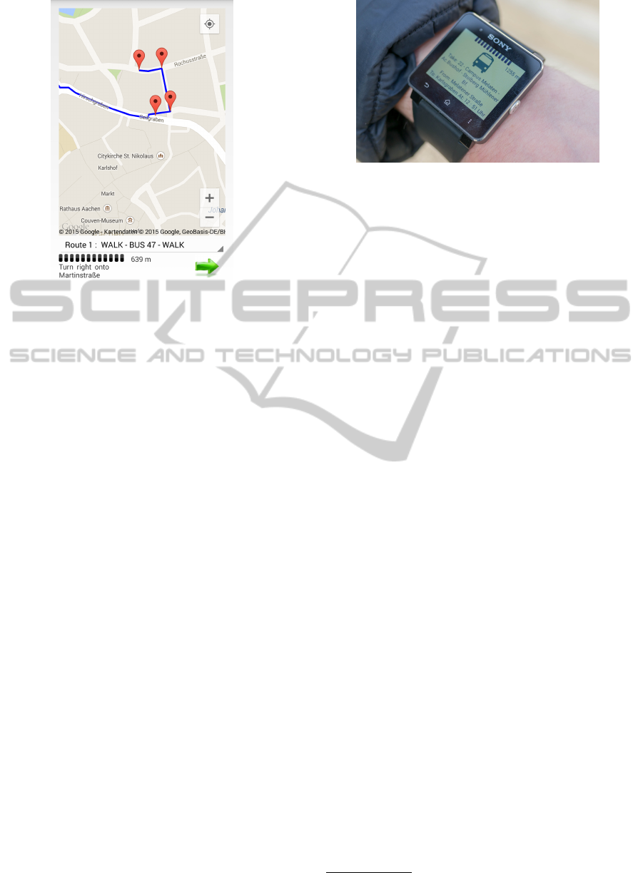
Figure 3: Example route parsed and visualized by the Route
Activity.
component displays the actual routing instructions.
The interaction between both components is handled
by the Sony Add-On SDK using Bluetooth.
4.1 Smartphone Component
The Smartphone component consists of three differ-
ent activities. The settings activity can be accessed
via pressing the hardware-button, allows changing of
static parameters, e.g., Server URI or standard zoom
level of the used map. The main activity waits for a
destination to be entered by the user. The activity than
sends a request to the backend and requests current
geolocation coordinates. Upon receiving the current
location of the user, the activity starts the route ac-
tivity by pressing a Plan-Button and sending the des-
tination address and the current location of the user.
The route activity sends a request to backend with in-
put information from the main activity and parses the
information provided by a backend. Afterwards the
activity initializes and visualizes the parsed result on
a map (see Figure 3), by using markers at each nav-
igation step. Subsequently it calculates the distance
between the user and the next waypoint, and alarms
the user as soon as he or she is in the direct vicin-
ity of the next waypoint. The calculated distance be-
tween the user and the next waypoint is also visual-
ized by a static progress bar and a text field provid-
ing the exact value. The distance between the user
and the next waypoint will be calculated each time the
GPS-routine is called. Each bar blanks out if the user
comes 50 meter closer to the waypoint. Also this ac-
tivity sends gathered information about the next way-
point and the user location to the Smartwatch.
Figure 4: Application prototype demonstration.
4.2 Smartwatch Component
The main functionality of the smartwatch is to visual-
ize the content received from the smartphone compo-
nent. Upon successfully receiving the information, a
vibrator is started to inform the user that he is in the
direct vicinity of the next waypoint. The Smartwatch
uses all information for the route and visualizes them
in a similar manner as the Smartphone does, but with-
out using the Map due to performance and visibility
issues. The Smartwatch component also shows the
distance to the next waypoint and uses a progress bar
to visualize the value.
The compass functionality was not added to the
applications since the compass/magnetic field sensor
support from Sony’s SmartWatch 2 has been removed.
The compass functionality of the Smartphone could
not been used either, since this would require that
the user aligns his or her smartphone in his or her
pocket/purse to the direction he is facing.
4.3 Routing Backend
To enable pedestrian and public transport assistance,
a routing solution is mandatory. We opted for the
open source routing planning framework OpenTrip-
Planner (OTP)
6
. OTP features intermodal trip plan-
ning with support for public transport, pedestrian nav-
igation and even support for rental bikes. OTP is a
Java application and consists of a server which per-
forms routing and supplementary services offered via
RESTful API.
OpenTripPlanner includes a graph builder tool
which parses any provided General Transit Feed
Specification (GTFS) data feed and determines the
required map excerpt. The required map data is
then automatically downloaded from OpenStreetMap.
To support public transport navigation we converted
timetable data supplied by the local mobility service
provider into the GTFS format.
6
http://opentripplanner.com
WEBIST2015-11thInternationalConferenceonWebInformationSystemsandTechnologies
638

5 EVALUATION
To evaluate the application respectively the approach
a user-oriented field test was conducted.
5.1 Methodology
The prototype application introduced in Section 4 was
assessed in a field test to determine the general feasi-
bility of the approach and to identify both technical
and usability problems with the prototype application
itself. The field test comprised a introduction to the
general handling of the smartwatch and smartphone,
a introductory scenario and two tasks which had to be
solved by navigating using the application. The pur-
pose of the scenario was to give the test participants a
contextual framing to balance out the different back-
grounds of the participants.
Scenario: “Assume you are a student using a smart-
phone and smartwatch, owning a student ticket and
using public transportation frequently. You work for
the student union and you often have contact to other
students with a variety of different fields of study.”
Task 1: “You start your day with the first lecture in
Audimax. During the lecture you receive an email
with the notification that your next tutorial had to be
moved to another building. Unfortunately, you do
not know the exact location of the building, but you
received the address of the building. You want to
know, how to get as soon as possible to the unknown
destination. The address you received via email is
Rochusstrasse 14 in Aachen.”
Task 2: “After your tutorial, you realize that you still
need to hand in an internship report for your friend.
Your friend is studying mechanical engineering and
is currently working in Hamburg. He has to hand in
his report today and he gave you his internship re-
port yesterday. You know the address of the destina-
tion, but you do not know the exact location of the
building. You planned your trip yesterday, but with
the moved tutorial you are not sure how to get to the
destination now. The address of your destination is
Sandkaulstrasse 9 in Aachen.”
During the test, participants were instructed to ap-
ply the thinking aloud method which means to com-
ment on their interaction with the application. For
lowering the cognitive load, task instructions were
handed over only after completing or terminating the
previous task. Verbal comments were briefly noted
and the number of interactions with smartwatch and
smartphone were logged. The feedback of partici-
pants was collected with a questionnaire based on the
Computer System Usability Questionnaire (CSUQ)
(Lewis, 1995; Lewis, 2002): CSUQ has a total of 19
questions, which are grouped into four different prop-
erties. The Usability evaluates out of questions 1 to
8, the Information Quality evaluates out of questions
9 to 15, the Interface Quality evaluates out of ques-
tions 16 to 18 and the overall rating evaluates out of
all properties and an additional question 19. Lewis et
al. suggested to use a Likert scale for the question-
naire. In this work a Likert scale was used, with a
range of: 1 (strongly disagree) to 5 (strongly agree).
Five test participants took part in the evaluation.
All five were male. Their age was M = 25.8 years
(M = mean value), SD = 3.63 (SD = standard devia-
tion). Four of them were students, one was a research
assistant. All participants stated they are enthusiastic
about technology, particularly computing.
5.2 Results
The three questions with the highest user rating mean
were: Question 16 (M = 4.8, SD = 0.45, ”The in-
terface of this system was pleasant.”), Question 7
(M = 4.6, SD = 0.89, ”It was easy to learn to use
this system.”) and Question 6 (M = 4.4, SD = 0.55, ”I
felt comfortable using this system.”). The three ques-
tions with the lowest user rating mean were: Ques-
tion 9 (M = 1.4, SD = 0.89, ”The system gave er-
ror messages that clearly told me how to fix prob-
lems.”), Question 11 (M = 1.75, SD = 1.5, ”The infor-
mation (such as on-line help, on-screen messages and
other documentation) provided with this system was
clear.”) and Question 10 (M = 3.2, SD = 0.84, ”When-
ever I made a mistake using the system, I could re-
cover easily and quickly.”). The other questions had a
mean rating between 4.2 and 3.8. The best rated ques-
tions pointed out that the groups Interface Quality and
Usability scored best and the group of Information
Quality scored worst. The Usability was rated with
M = 4.14, SD = 0.81, the Information Quality was
rated with M = 3.07, SD = 3.3, the Interface Quality
was rated with M = 4.2, SD = 0.77 and the Overall
Rating was M = 3.83, SD = 1.08.
Besides the usability assessment using the CSUQ,
participants gave detailed feedback on the prototype’s
visualization and features by writing down comments
in the questionnaire and uttering them during the eval-
uation. Many positive comments were made on the
prototype in general. One participant stated: ”I really
liked that the Smartwatch displayed the distance to
the next waypoint while navigating by foot.” Another
participant stated: ”I really liked the vibration notifi-
cations.” In addition, they acknowledged the minimal-
istic design of the applications, the integrated map and
the automatic step-by-step support during the journey.
Further negative comments addressed the Information
UsingWearablesforTravelAssistance
639
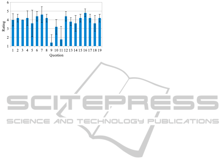
Figure 5: The mean value and the corresponding standard
deviations, of the collected user ratings for all CSUQ ques-
tions. The values have a range from 1 (strongly disagree) to
5 (strongly agree).
Quality of the application. Test participants criticized
that the information about the cardinal directions after
deboarding from public transport or starting their nav-
igation, wasn’t helping to find the directions they had
to go to. One participant also said: ”I wasn’t really us-
ing the progress bar, if I needed the information about
the distance I always used the [displayed] value.”
The participants used for the first route, the Smart-
phone application seven times in total (M = 1.4,
SD = 0.55) and for the second route 11 times in to-
tal (M = 2.2, SD = 0.84). The Smartwatch has been
used 54 times in total (M = 10.8, SD = 1.92) for the
first route and for the second route 86 times in total
(M = 17.2, SD = 4.15).
5.3 Discussion
The worst rated questions are easily explainable since
this prototype did not implement any error messages
or additional information (such as on-line help or
other documentation). In fact, these questions were
better rated than thought, since some users just didn’t
run into errors while evaluating the application. If
one removes the three questions about error mes-
sages and on-line help or other documentation, the
Information Quality rating increases to M = 4, SD =
0.65 and the Overall rating increases to M = 4.13,
SD = 0.72. Overall, the participants preferred us-
ing the Smartwatch instead of the Smartphone, which
is shown by the number of interactions (Smartwatch
M = 10.8/M = 17.2 vs. Smartphone M = 1.4/M =
2.2). The smartphone component can be considered
as a backup solution for complex situation in which
the smartwatch is not sufficient, e.g., if the partici-
pants did not know in which cardinal direction they
had to go or if they were not sure if they are still on
the right track. During the evaluation one could ob-
serve that the progress bar was not used by the major-
ity of the participants. Most of the participants did not
look at the smartwatch while navigating, they rather
performed one navigation step and afterwards went
forward until the next vibration signal appeared to de-
liver the next navigation step. Some users also stated
that they would like to use a compass for the cardinal
directions directly on the smartwatch (was not possi-
ble due to technical restrictions).
6 CONCLUSION
This paper presented an approach for assisting trav-
elers on their public transport-based journey using a
wearable device. The prototype was realized follow-
ing the cascading information principle using a Sony
SmartWatch 2 and using OpenTripPlanner as routing
backend. The prototype application was evaluated in
a real world field test to gain insights about the fea-
sibility of the approach and usability issues with the
specific implementation. The results showed that gen-
eral approach of using a wearable in addition to a
smartphone for navigation is beneficial compared to
only using a smartphone.
Future Work
Although, this work showed that the approach is fea-
sible, there is still some work remaining. The feed-
back provided by the participants revealed that show-
ing the distance to the next intermediate point is not
useful; while walking participants had problems ap-
proximating the distance and while riding a bus, it is
irrelevant. Instead, it is supposedly better to calcu-
late the remaining time based on the walking speed
or using realtime traffic information for public trans-
port. (May et al., 2003) suggested another approach
for navigation, by adding information about their sur-
roundings (e.g.: Turn left at the cross-way with the
traffic light.). This approach could be used to avoid
to use cardinal directions, but would require a huge
amount of underlying data. Potentially the Cascading
Information principle might be transferable to wear-
ables applications in different domains, but this is
beyond our scope. The user test itself, with a rela-
tive low number of participants, can hardly give any
quantitative feedback. Consequently in a further itera-
tion of the development cycle the evaluation should be
conducted with a higher number of participants. Last
but not least, the presented application is just avail-
able for a single platform, for Sony SmartWatch. For
a productive usage, more wearable platforms have to
be supported.
WEBIST2015-11thInternationalConferenceonWebInformationSystemsandTechnologies
640

ACKNOWLEDGEMENTS
The authors would like to thank the participants of
the user study for their patience and time. The au-
thors would also like to thank ASEAG AG and IVU
Traffic Technologies AG for supplying the required
timetable data. This work was founded by German
Federal Ministry of Economics and Technology for
project Mobility Broker (01ME12135A).
REFERENCES
Baus, J., Kr
¨
uger, A., and Wahlster, W. (2002). A Resource-
Adaptive Mobile Navigation System. In Proceed-
ings of the 7th International Conference on Intelligent
User Interfaces (IUI 2002), pages 15–22, New York,
NY, USA. ACM.
Beul-Leusmann, S., Samsel, C., Wiederhold, M., Krempels,
K., Jakobs, E., and Ziefle, M. (2014). Usability evalu-
ation of mobile passenger information systems. In De-
sign, User Experience, and Usability. Theories, Meth-
ods, and Tools for Designing the User Experience -
Third International Conference, DUXU 2014, Crete,
Greece, June 22-27, 2014, Proceedings, pages 217–
228.
Camacho, T., Foth, M., and Rakotonirainy, A. (2012). Per-
vasive Technology and Public Transport: Opportuni-
ties beyond Telematics. IEEE Pervasive Computing,
12(1):18–25.
Chapman, L. (2007). Transport and climate change: a re-
view. Journal of Transport Geography, 15(5):354–
367.
Chowaw-Liebman, O., Christoph, U., Krempels, K.-H., and
Terwelp, C. (2010). Indoor Navigation Approach
Based on Approximate Positions. In Proceedings of
the International Conference on Indoor Positioning
and Indoor Navigation (IPIN 2010), pages 15–17.
Gorlatova, M., Wallwater, A., and Zussman, G. (2013).
Networking Low-Power Energy Harvesting Devices:
Measurements and Algorithms. Mobile Computing,
IEEE Transactions on, 12(9):1853–1865.
Heiniz, P., Krempels, K.-H., Terwelp, C., and W
¨
uller,
S. (2012). Landmark-based Navigation in Complex
Buildings. In Proceedings of the International Con-
ference on Indoor Positioning and Indoor Navigation
(IPIN 2012), pages 1–9.
Jiang, S., Sakai, K., Yamada, M., Fujimoto, J., Hidaka,
H., Okabayashi, K., and Murase, Y. (2014). Devel-
oping a Wearable Wrist Glove for Fieldwork support:
A user Activity-driven Approach. In IEEE/SICE In-
ternational Symposium on System Integration (SII),
pages 22–27.
Jonas, S., Hannig, A., Spreckelsen, C., and Deserno, T. M.
(2014). Wearable Technology as a Booster of Clini-
cal Care. In SPIE Medical Imaging, pages 90390F–
90390F–6. International Society for Optics and Pho-
tonics.
Lewis, J. R. (1995). IBM Computer Usability Satisfac-
tion Questionnaires: Psychometric Evaluation and In-
structions for Use. International Journal of Human-
Computer Interaction, 7(1):57–78.
Lewis, J. R. (2002). Psychometric Evaluation of the PSSUQ
using Data from Five Years of Usability Studies. In-
ternational Journal of Human-Computer Interaction,
14(3-4):463–488.
Lymberis, A. (2005). Wearable Health Systems and Appli-
cations: The Contribution of Information and Com-
munication Technologies. In Proceedings of the 27th
Annual International Conference on Engineering in
Medicine and Biology Society (IEEE-EMBS 2005).,
pages 4149–4152.
May, A. J., Ross, T., Bayer, S. H., and Tarkiainen, M. J.
(2003). Pedestrian Navigation aids: Information Re-
quirements and Design Implications. Personal and
Ubiquitous Computing, 7(6):331–338.
Meng, Y., Choi, H.-K., and Kim, H.-C. (2011). Exploring
the User Requirements for Wearable Healthcare Sys-
tems. In Proceedings of the 13th IEEE International
Conference on e-Health Networking Applications and
Services (Healthcom 2011), pages 74–77.
Pascoe, J., Ryan, N., and Morse, D. (2000). Using
while moving: HCI issues in fieldwork environments.
ACM Transactions on Computer-Human Interaction
(TOCHI), 7(3):417–437.
Samsel, C., Beul-Leusmann, S., Wiederhold, M., Krempels,
K., Ziefle, M., and Jakobs, E. (2014). Cascading Infor-
mation for Public Transport Assistance. In Proceed-
ings of the 10th International Conference on Web In-
formation Systems and Technologies (WEBIST 2014),
Barcelona, Spain, 3-5 April, 2014, pages 411–422.
Sun, M., Burke, L., Mao, Z.-H., Chen, Y., Chen, H.-C.,
Bai, Y., Li, Y., Li, C., and Jia, W. (2014). eButton:
A Wearable Computer for Health Monitoring and Per-
sonal Assistance. In 51st ACM/EDAC/IEEE Design
Automation Conference (DAC 2014), pages 1–6.
Wei, J. (2014). How Wearables Intersect with the Cloud and
the Internet of Things : Considerations for the Devel-
opers of Wearables. Consumer Electronics Magazine,
IEEE, 3(3):53–56.
Wenig, D., Brending, S., Runge, N., and Malaka, R. (2014).
Using Split Screens to Combine Maps and Images
for Pedestrian Navigation. Journal of Location Based
Services, 8(3):179–197.
Zargamy, A., Sakai, H., Ganh
¨
or, R., and Oberwandling, G.
(2013). Fußg
¨
angernavigation im urbanen Raum - De-
signvorschlag (Pedestrian Navigation in Urban Space
- Design Proposal). In Boll, S., Maaß, S., and Malaka,
R., editors, Mensch & Computer 2013: Interaktive
Vielfalt, Interdisziplin
¨
are Fachtagung, 8.-11. Septem-
ber 2013, Bremen, Germany, pages 365–368. Olden-
bourg Verlag.
UsingWearablesforTravelAssistance
641
