STEP NAVI
A Navigation Support System by Visualization of Walking Speed
Kazuya Fujisawa
1
and Michiaki Yasumura
2
1
Graduate School of Media and Governance, Keio University, Kanagawa, Japan
2
Faculity of Environment and Information studies, Keio University, Kanagawa, Japan
Keywords:
Navigation, Walking Speed, Gradation, GPS, Location Information.
Abstract:
In recent years, users of walking navigation services is increasing with the spread of smart phones, such as
iPhone and Android. Walking navigation utilizes GPS function in a smart phone to find out current position
of a user. When using route navigation, users would like to arrive at their destination correctly. However, in
many cases, this is not the only purpose that they would like to accomplish. They also would like to arrive at
the destination in time. In this research, we propose a system called “StepNavi” that allows a user to know
current walking speed is over paced or under paced.
1 INTRODUCTION
In this research, we propose a speed navigation sys-
tem called “StepNavi” which presents the optimal
pace as support for arrival at the destination in time.
In recent years, users of walking navigation ser-
vices is increasing with the spread of smart phones,
such as iPhone and Android. Walking navigation uti-
lizes GPS function in a smart phone to find out cur-
rent position of a user. Together with destination in-
formation, detailed route navigation help the user ar-
rive at the destination without seeing the map of paper
medium. When using route navigation, users would
like to arrive at their destination correctly. However,
in many cases, this is not the only purpose that they
would like to accomplish. They also would like to ar-
rive at the destination in time. At present, whether the
user will be in time for a target time or not is left to the
user. As a result, one user may be too late for the tar-
get time, another may be too early, thus giving them
some uneasiness while using navigation systems.
In this research, we propose a system called “Step-
Navi” that allows a user to know current walking
speed is over paced or under paced. Walking speed
is computed based on user’s positions and travel time
between them. Besides a numerical display, the sys-
tem displays the walking speed of user’s in an intu-
itive interface, which helps users understand adequate
pace of walking.
2 STEP NAVI
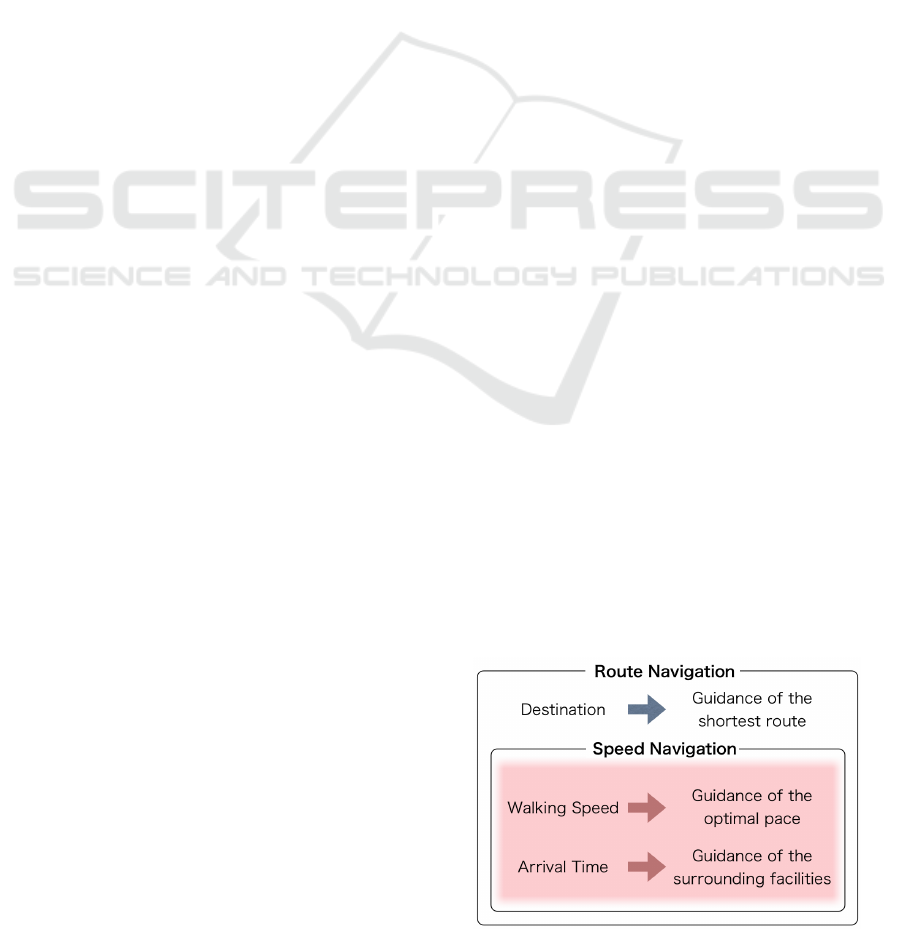
Figure 1 expresses the novelty of this research
“StepNavi”. “StepNavi” performs speed Navigation.
Speed navigation is realized based on the existing
route navigation. Speed Navigation is using walking
speed and arrival time and offers various support.
Figure 2 is a screen of screenshot of this system
“STEP NAVI”. The purpose of ”STEP NAVI” is to
allows a user to know current walking speed is over
paced or under paced. Walking speed is computed
based on user’s positions and travel time between
them, it visualizes with the intuitive interface which
proposed a speed information for a user.
Figure 1: Novelty.
788
Fujisawa K. and Yasumura M..
STEP NAVI - A Navigation Support System by Visualization of Walking Speed.
DOI: 10.5220/0003926807880790
In Proceedings of the International Conference on Computer Graphics Theory and Applications (IVAPP-2012), pages 788-790
ISBN: 978-989-8565-02-0
Copyright
c
2012 SCITEPRESS (Science and Technology Publications, Lda.)
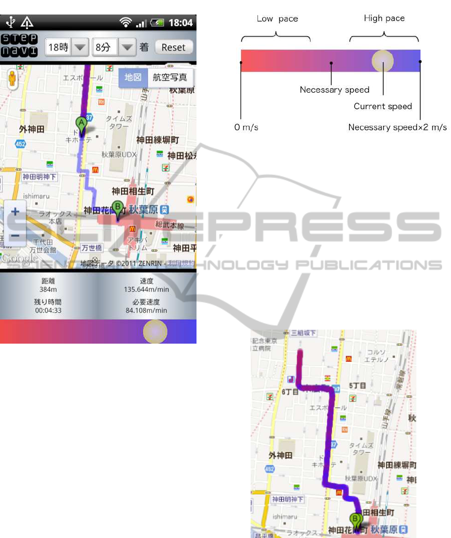
Figure 2: Step Navi.
2.1 Gradation Interface
This system displays current speed and necessary
speed as a numerical value of speed per minute.
However, since we hardly consider walking speed by
speed per minute or speed per hour, we considered
that the intuitive interface which can understand nec-
essary speed is required.
Figure 3 shows the proposed gradation interface.
It is a gradation bar from red to blue, yellow sphere
expresses a user’s current speed and a central pur-
ple portion expresses necessary speed. Moreover, it
expresses that a left-hand side of red portion has a
low pace and a right-hand side of blue portion has an
high pace. Therefore, if a sphere is on the right from
the center, it turns out that the user can arrive earlier
than time to reach. A left end expresses speed 0 m/s
and the right end expresses speed twice the necessary
speed. However, since necessary speed is computed
from the remaining distance and the remaining time,
it changes relatively.
Figure 3: Gradation interface.
2.2 Display of a Track
Figure 4 shows the user’s track. The color of the cur-
rent speed in the moment is added to a user’s track.
The color of the current speed is a color in the po-
sition where the sphere which expresses the current
speed was displayed on gradation Interface of Figure
3. When a user judges that the current speed is low
pace and pick up the pace, it is for understanding pick
up the pace by seeing change of the color of the track.
Since the user can understand intuitively know how
much speed are fluctuating, it becomes unnecessary
for a user to look at a screen frequently.
Figure 4: Display of the user’s track.
2.3 Surrounding Facilities
Figure 5 shows the structure of the system. A sur-
rounding facilities is recommended according to be-
tween a user’s arrival time. Only a cafe and a conve-
nience store are recommended now.
STEP NAVI - A Navigation Support System by Visualization of Walking Speed
789

Figure 5: Surrounding facilities.
3 IMPLEMENTATION
Figure 6 shows the structure of the system. This sys-
tem is divided into two main classes, a client side
and a server side . In client side, navigation is per-
formed using Google maps API which Google offers.
In server side, recommendation is performed using
Open Local Platform which Yahoo offers.
Figure 6: The system configuration diagram.
4 DISCUSSION
Since this system is carrying out positioning of the lo-
cation information using the GPS function of a smart
phone, a user’s walking speed computed from loca-
tion information is dependent on the accuracy of po-
sitioning. Now, the acquisition accuracy of GPS is set
up highly and only location information with a high
accuracy value is acquired. However, a place with
many buildings and the place where the positioning
by GPS is difficult, it may acquire the location infor-
mation from which it may be separated greatly from
a its present location. Therefore, distance is period-
ically computed from two or more location informa-
tion, and when distance becomes large, it is necessary
to delete as a noise.
5 CONCLUSIONS
In the conventional navigation, a user has the uneasi-
ness whether the current walk pace good or not, when
the pace is too late, the problem the user can’t reach
in time as a result many occur. Then, we computed
the user’s walking speed in real time, and considered
that it should make it compare with necessary speed.
In this research, we proposed a concept as speed navi-
gation and prototyped the ”StepNavi” which displays
a user’s walking speed and necessary speed.
REFERENCES
Google (2011a). Goole maps api. http://code.google.com/
intl/ja/apis/maps/.
Google (2011b). Mobile google map. http://www.google.
co.jp/mobile/maps/.
ItumoNAVI (2011). http://www.its-mo.com/.
NAVITIME (2011). http://www.navitime.co.jp/.
Nike+GPS (2011). http://itunes.apple.com/jp/app/nike-
gps/id387771637.
Yahoo (2011). Yahoo open local platform api.
http://developer.yahoo.co.jp/webapi/map/.
Yano, M., Iwasaki, Y., and Kawaguchi, N. (2010). Ekilo-
cky: Time table information system using wifi loca-
tion technology. In Proceedings of the 72th Annual
Convention IPS Japan.
IVAPP 2012 - International Conference on Information Visualization Theory and Applications
790
